
Los Angeles County, officially the County of Los Angeles, and sometimes abbreviated as L.A. County, is the most populous county in the United States, with 9,861,224 residents estimated in 2022. Its population is greater than that of 40 individual U.S. states. Comprising 88 incorporated cities and many unincorporated areas within a total area of 4,083 square miles (10,570 km2), it is home to more than a quarter of Californians and is one of the most ethnically diverse U.S. counties. The county's seat, Los Angeles, is the second most populous city in the United States, with about 3.9 million residents. Being the home of the U.S. motion-picture industry, since its inception in the early 20th century, has given the county global prominence.
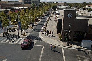
Lancaster is a charter city in northern Los Angeles County, in the Antelope Valley of the western Mojave Desert in Southern California. As of the 2020 census, the population was 173,516, making Lancaster the 153rd largest city in the United States and the 30th largest in California. Lancaster is a twin city with its southern neighbor Palmdale; together, they are the principal cities within the Antelope Valley region.

Littlerock is a census-designated place in California United States. The population was 1,377 at the 2010 census, down from 1,402 at the 2000 census. The Littlerock, and Sun Village community, which is typically referred to as Littlerock, has a population around 15,000. According to the Greater Antelope Valley Economic Alliance report of 2009, the Palmdale / Lancaster urban area has a population of 483,998, which Littlerock is a part of.

Palmdale is a city in northern Los Angeles County in the U.S. state of California. The city lies in the Antelope Valley of Southern California. The San Gabriel Mountains separate Palmdale from the Los Angeles Basin to the south.

Quartz Hill is a census-designated place (CDP) in Los Angeles County, California, United States. The population was 10,912 at the 2010 census, up from 9,890 at the 2000 census. The name is also shared with the neighboring district areas of its border cities, Palmdale, and Lancaster. Quartz Hill was once home to the Quartz Hill Airport. According to the Greater Antelope Valley Economic Alliance report of 2009, the Palmdale / Lancaster urban area of which Quartz Hill is a part, has a population of 483,998.
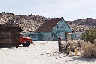
Lake Los Angeles is a census-designated place (CDP) in Los Angeles County, California, United States. The population was 12,328 at the 2010 census, up from 11,523 at the 2000 census. It is located 17 miles (27 km) east of Palmdale's Civic Center. According to the Greater Antelope Valley Economic Alliance report of 2009, the Palmdale / Lancaster urban area has a population of 483,998, of which Lake Los Angeles is a part.

Antelope Valley California Poppy Reserve is a state-protected reserve of California, United States, harboring the most consistent blooms of California poppies, the state flower. The reserve is located in the rural west side of Antelope Valley in northern Los Angeles County, 15 miles (24 km) west of Lancaster. To the north is Kern County. The reserve is at an elevation ranging from 2,600 to 3,000 feet above sea level, in the Mojave Desert climate zone. The reserve is administered by the California Department of Parks and Recreation. Other wildflowers within the reserve include the Owl's Clover, Lupine, Goldfields, Cream Cups and Coreopsis.
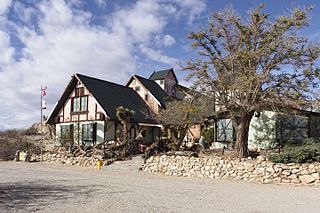
The Antelope Valley Indian Museum State Historic Park is a state historic park of California, United States, interpreting Native American cultures of the Great Basin and surrounding regions. The park and its grounds are situated on the Antelope Valley's rural east side in northern Los Angeles County, California.

The Antelope Valley is located in northern Los Angeles County, California, United States, and the southeast portion of California's Kern County, and constitutes the western tip of the Mojave Desert. It is situated between the Tehachapi, Sierra Pelona, and the San Gabriel Mountains. The valley was named for the pronghorns that roamed there until they were all eliminated in the 1880s, mostly by hunting, or resettled in other areas. The principal cities in the Antelope Valley are Palmdale and Lancaster.

Antelope is a census-designated place in Sacramento County, California, United States located approximately 15 miles (24 km) northeast of downtown Sacramento and 5 miles (8 km) southwest of Roseville. The population was 45,770 at the 2020 census.

Antelope Acres is an unincorporated community in Los Angeles County, California. It lies at an elevation of 2425 feet.

Antelope Valley College (AVC) is a public community college in Lancaster, California. It is part of the California Community College system. It is operated by the Antelope Valley Community College District, with a primary service area of 1,945 square miles (5,040 km2) covering portions of Los Angeles and Kern counties. Instruction is offered at several sites, including Palmdale and Lancaster, and through online and instructional television courses.
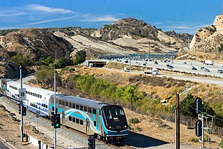
The Antelope Valley Line is a commuter rail line that serves the Northern Los Angeles County area as part of the Metrolink system. The northern segment of the line is rural in character because it travels through the sparsely populated Soledad Canyon between Santa Clarita and Palmdale, serving the small community of Acton along the way. Other portions of its route parallel the former US Route 6, now San Fernando Road and Sierra Highway. This is the only Metrolink line contained entirely within Los Angeles County.

The Kawaiisu are a Native Californian ethnic group in the United States who live in the Tehachapi Valley and to the north across the Tehachapi Pass in the southern Sierra Nevada, toward Lake Isabella and Walker Pass. Historically, the Kawaiisu also traveled eastward on food-gathering trips to areas in the northern Mojave Desert, to the north and northeast of the Antelope Valley, Searles Valley, as far east as the Panamint Valley, the Panamint Mountains, and the western edge of Death Valley. Today, some Kawaiisu people are enrolled in the Tule River Indian Tribe.

Antelope Valley High School is located in Lancaster, California, and is part of the Antelope Valley Union High School District, in northernmost Los Angeles County, California. It was founded in 1912, and had its first graduating class in 1912. It is located near the western edge of the Mojave Desert. At the time of its founding, classes were held at the Women's Independence Hall on Cedar Ave. and Lancaster Blvd. until a permanent building could be built. In July 1914, construction was planned to begin on a concrete building, Central Hall, but construction didn’t begin until 1915 and was completed in mid-1915. However, a strike over unpaid wages prevented students from entering the new building at the beginning of the 1915 school year. It was settled, and students began their classes in the new building in October 1915. The school was a residential boarding school serving students from farms and ranches from north Los Angeles and south Kern counties. At present, the school primarily serves the population of Lancaster, California.

Newhall station is an intermodal hub in the Newhall neighborhood of Santa Clarita, California. The station is served by Metrolink's Antelope Valley Line operating between Los Angeles Union Station and Lancaster, Amtrak Thruway buses connecting to/from San Joaquins trains in Bakersfield, and serves as a transfer point in the City of Santa Clarita Transit bus system.

The Palmdale Transportation Center is a multi-modal transportation center in the city of Palmdale, California. Featuring a Metrolink rail station, a local bus hub, and commuter bus hub, the center was completely rebuilt in April 2005. It features a "clock tower plaza" which has an enclosed waiting room with concessions and vending, public telephone, restrooms, a bus pass sales office, and security service. The center has four partially enclosed shelters at the bus hub and six partially enclosed shelters for the rail platform. The center also has a large park and ride facility with 586 spaces.
Antelope Valley Medical Center (AVMC) is a public hospital located in Lancaster, California specializing in acute care. It has 420 beds and is accredited by the Joint Commission. In March 2010 AVMC was declared one of the 14 trauma centers in Los Angeles County.
The Westside Union School District in Southern California serves the western parts of Palmdale and Lancaster and their immediate suburbs, including Quartz Hill, Del Sur, Leona Valley, Antelope Acres, and Neenach.

The Antelope Fire was a wildfire that burned in the Klamath National Forest, the Modoc National Forest, the Shasta-Trinity National Forest, and in Lava Beds National Monument in Siskiyou County, California, in the United States. The fire was started by a lightning strike and was first reported on August 1, 2021. As of October 15th, the fire had burned 145,632 acres (58,935 ha).


