Area codes 760 and 442

Last updated
Numbering plan areas in California (blue) and border states. Area codes 442 and 760 are shown in red. Area code 442.svg458/541775702928442/760916/279530707209559831805661858909951619213323707916/279415650510/341925408209831805661442/760310/424747/818626909951949562657/714
Numbering plan areas in California (blue) and border states. Area codes 442 and 760 are shown in red.

Area codes 760 and 442 are telephone area codes in the North American Numbering Plan (NANP) for the U.S. state of California. These area codes serve an overlay complex that comprises much of the southeastern and southernmost portions of California. It includes Imperial, Inyo, and Mono counties, as well as portions of San Diego, Riverside, San Bernardino, Los Angeles and Kern counties. Area code 760 was created on March 22, 1997 in a split of area code 619. [1] Area code 442 was added to the same area on November 21, 2009.

Contents

History

Area code 760 was split from 619 in 1997, and 619 had been split from area code 714 in 1982. Within a decade of creation, the proliferation of cell phones and pagers left area code 760 under the threat of exhausting its central office prefixes. The initial relief plan was another area code split, with the San Diego and Imperial areas moving to a new 442 area code. However, this met with protests from businesses who did not want to change their numbers for the second time in a decade. Ultimately, the California Public Utilities Commission decided that 442 would be added as an overlay to 760. Since 2009 all users in the region have been required to include the area code even when dialing local calls.
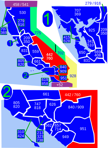
At 46,666 square miles (120,860 km2), it is the largest numbering plan area in California with approximately 29% of the state served by area codes 760 and 442. [2]

Service area

The following communities are located in the numbering plan area, in their respective counties.

Imperial County

Inyo County

Kern County

Los Angeles County

Mono County

Riverside County

San Bernardino County

San Diego County

See also

Related Research Articles

<span class="mw-page-title-main">Southern California</span> American geographic and cultural region

Southern California is a geographic and cultural region that generally comprises the southern portion of the U.S. state of California. It includes the Los Angeles metropolitan area as well as the Inland Empire. The region generally contains ten of California's 58 counties: Imperial, Kern, Los Angeles, Orange, Riverside, San Bernardino, San Diego, Santa Barbara, San Luis Obispo and Ventura counties.

<span class="mw-page-title-main">Imperial County, California</span> County in California, United States

Imperial County is a county located on the southeast border of the U.S. state of California. As of the 2020 census, the population was 179,702, making it the least populous county in Southern California. The county seat and largest city is El Centro. Imperial is the most recent California county to be established, as it was created in 1907 out of portions of San Diego County.

<span class="mw-page-title-main">Anza-Borrego Desert State Park</span> State park in California, United States

Anza-Borrego Desert State Park is a California State Park located within the Colorado Desert of southern California, United States. The park takes its name from 18th century Spanish explorer Juan Bautista de Anza and borrego, a Spanish word for sheep. With 585,930 acres (237,120 ha) that includes one-fifth of San Diego County, it is the largest state park in California and the third largest state park nationally.

<span class="mw-page-title-main">Low Desert</span> Informal term for certain areas in California, US

The Low Desert is a common name for any desert in California that is under 2,000 feet in altitude. These areas include, but are not exclusive to, the Colorado Desert and Yuha Desert branches of the Sonoran Desert, in the far southeasternmost portion of Southern California. The Low Desert is distinguished in biogeography from the adjacent northern High Desert or Mojave Desert by latitude, elevation, animal life, climate, and native plant communities.

<span class="mw-page-title-main">Coachella Valley</span> Valley in Southern California

The Coachella Valley is an arid rift valley in the Colorado Desert of Southern California in Riverside County. The valley has been referred to as Greater Palm Springs and occasionally the Palm Springs Area due to the historic prominence of the city of Palm Springs. The valley extends approximately 45 mi (72 km) southeast from the San Gorgonio Pass to the northern shore of the Salton Sea and the neighboring Imperial Valley, and is approximately 15 mi (24 km) wide along most of its length. It is bounded on the northeast by the San Bernardino and Little San Bernardino Mountains, and on the southwest by the San Jacinto and Santa Rosa Mountains.

<span class="mw-page-title-main">Santa Rosa Mountains (California)</span> Mountain range in California

The Santa Rosa Mountains are a short mountain range in the Peninsular Ranges system, located east of the Los Angeles Basin and northeast of the San Diego metropolitan area of southern California, in the southwestern United States.

<span class="mw-page-title-main">Colorado Desert</span> Subdivision of the larger Sonoran Desert, California

Colorado Desert is a part of the larger Sonoran Desert located in California, United States and Baja California, Mexico. It encompasses approximately 7 million acres, including the heavily irrigated Coachella, Imperial and Mexicali valleys. It is home to many unique flora and fauna.

<span class="mw-page-title-main">Cahuilla</span> Native American people, living in the inland areas of southern California

The Cahuilla, also known as ʔívil̃uqaletem or Ivilyuqaletem, are a Native American people of the various tribes of the Cahuilla Nation, living in the inland areas of southern California. Their original territory included an area of about 2,400 square miles (6,200 km2). The traditional Cahuilla territory was near the geographic center of Southern California. It was bounded to the north by the San Bernardino Mountains, to the south by Borrego Springs and the Chocolate Mountains, to the east by the Colorado Desert, and to the west by the San Jacinto Plain and the eastern slopes of the Palomar Mountains.

The State Scenic Highway System in the U.S. state of California is a list of highways, mainly state highways, that have been designated by the California Department of Transportation (Caltrans) as scenic highways. They are marked by the state flower, a California poppy, inside either a rectangle for state-maintained highways or a pentagon for county highways.

<span class="mw-page-title-main">Area codes 619 and 858</span> Area codes for San Diego County, California

Area codes 619 and 858 are telephone area codes in the North American Numbering Plan (NANP) for most of San Diego County in the U.S. state of California. Area code 619 was created by a split of area code 714 in 1982. In 1999, a part of the 619 numbering plan area was assigned area code 858 in northwest San Diego County. In 2019, the area code boundary between 619 and 858 was eliminated, creating an overlay complex with the two area codes.

<span class="mw-page-title-main">Chiriaco Summit, California</span> Unincorporated community in California, United States

Chiriaco Summit is a small unincorporated community and travel stop located along Interstate 10 in the Colorado Desert of Southern California. It lies 19 miles (31 km) west of Desert Center on the divide between the Chuckwalla Valley and the Salton Sea basin at an elevation of 1,706 feet (520 m).

<span class="mw-page-title-main">Area code 661</span> Area code in central and southern California, United States

Area code 661 is a telephone area code in the North American Numbering Plan for the southern part of the San Joaquin Valley and for the far northern part of the Los Angeles metropolitan area. The numbering plan area comprises most of Kern County, most of northern Los Angeles County, and small parts of Ventura County, Santa Barbara County, and Tulare County. It was created in an area code split of area code 805 on February 13, 1999.

<span class="mw-page-title-main">Ocotillo Wells, California</span> Unincorporated community in California, United States

Ocotillo Wells is an unincorporated community in San Diego County, California, United States. It is 3 miles (4.8 km) west of the Imperial County line on California State Route 78 at an elevation of 163 feet (50 m). The name became official in 1962 when it was adopted for federal use by the US Board on Geographic Names. A federally recognized variant name, Ocotillo, can cause confusion with the community of Ocotillo, California in Imperial County, 29 mi (47 km) to the south on Interstate 8.

<span class="mw-page-title-main">High Desert (California)</span> Geographic area of southern California

High Desert is a vernacular region with non-discrete boundaries covering areas of the western Mojave Desert in Southern California. The region encompasses various terrain with elevations generally between 2,000 and 4,000 ft above sea level, and is located just north of the San Gabriel, San Bernardino, and Little San Bernardino Mountains.

<span class="mw-page-title-main">Los Angeles Air Route Traffic Control Center</span> Area control center of the United States

The Los Angeles Air Route Traffic Control Center is an air traffic control center located in Palmdale, California, United States. Located adjacent to United States Air Force Plant 42 and the Palmdale Regional Airport, it is one of 22 Air Route Traffic Control Centers (ARTCC) operated by the United States Federal Aviation Administration (FAA).

<span class="mw-page-title-main">Deserts of California</span> Region of California

The deserts of California are the distinct deserts that each have unique ecosystems and habitats. The deserts are home to a sociocultural and historical "Old West" collection of legends, districts, and communities, and they also form a popular tourism region of dramatic natural features and recreational development. Part of this region was even proposed to become a new county due to cultural, economic and geographic differences relative to the rest of the more urban region.

<span class="mw-page-title-main">Coyote Mountains</span> Mountain range in California, United States

The Coyote Mountains are a small mountain range in San Diego and Imperial Counties in southern California. The Coyotes form a narrow ESE trending 2 mi (3.2 km) wide range with a length of about 12 mi (19 km). The southeast end turns and forms a 2 mi (3.2 km) north trending "hook". The highest point is Carrizo Mountain on the northeast end with an elevation of 2,408 feet (734 m). Mine Peak at the northwest end of the range has an elevation of 1,850 ft (560 m). Coyote Wash along I-8 along the southeast margin of the range is 100 to 300 feet in elevation. Plaster City lies in the Yuha Desert about 5.5 mi (8.9 km) east of the east end of the range.

<span class="mw-page-title-main">Riverside County, California</span> County in California, United States

Riverside County is a county located in the southern portion of the U.S. state of California. As of the 2020 census, the population was 2,418,185, making it the fourth-most populous county in California and the 10th-most populous in the United States. The name was derived from the city of Riverside, which is the county seat.

<span class="mw-page-title-main">Flora of the Colorado Desert</span>

Flora of the Colorado Desert, located in Southern California. The Colorado Desert is a sub-region in the Sonoran Desert ecoregion of southwestern North America. It is also known as the Low Desert, in contrast to the higher elevation Mojave Desert or High Desert, to its north.

References

  1. "California area codes - Map, list, and phone lookup".
  2. 760/442 area code. California Public Utilities Commission. Accessed July 31, 2017.
California area codes: 209, 213/323, 279/916, 310/424, 341/510, 408/669, 415/628, 442/760, 530, 559, 562, 619/858, 626, 650, 657/714, 661, 707, 747/818, 805/820, 831, 840/909, 925, 949, 951
North: 530, 702/725, 775
West: 209, 559, 619/858, 626, 661, 808, 909, 951, 949 442/760East: 928
South: 619/858, Country code +52 in Mexico
Arizona area codes: 480/602/623, 520, 928
Nevada area codes: 702/725, 775
Hawaii area codes: 808

35°N116°W / 35°N 116°W / 35; -116