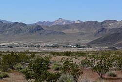
Shoshone, California

Last updated

Shoshone
Shoshone California.jpg
View of Shoshone from the east
Inyo County California Incorporated and Unincorporated areas Shoshone Highlighted.svg
Location in Inyo County and the state of California
Usa edcp location map.svg
Red pog.svg
Shoshone
Location in the United States
Coordinates: 35°58′23″N116°16′16″W / 35.97306°N 116.27111°W / 35.97306; -116.27111
Country Flag of the United States (23px).png  United States
State Flag of California.svg  California
County Inyo
Area
[1]
  Total28.711 sq mi (74.361 km2)
  Land28.711 sq mi (74.361 km2)
  Water0 sq mi (0 km2)  0%
Elevation
[2]
2,595 ft (791 m)
Population
  Total22
  Density0.77/sq mi (0.30/km2)
Time zone UTC-8 (Pacific)
  Summer (DST) UTC-7 (PDT)
ZIP code
92384
Area codes 442/760
FIPS code 06-71680
GNIS feature ID2408733 [2]

Shoshone is a census designated place (CDP) in Inyo County, California, United States. The population was 22 at the 2020 census, down from 31 at the 2010 census. [3]

Contents

The town was founded in 1910. Although small, it is notable as a southern gateway to Death Valley National Park; in addition to being a junction of roads leading from Baker, California and Pahrump, Nevada, it has the last services available before the Furnace Creek area in the park. The commercial district of the town, including a post office, gas station, restaurant, bar and coffee house, is just north of the southern intersection of California State Routes 127 and 178.

Shoshone has a single 2,380 foot (725 m) airstrip across SR 127 from the commercial district. It is open to the public and gets about 58 flights per month. [4]

Shoshone, California, has a history as a railroad town and rich mining district. [5]

Geography

According to the United States Census Bureau, the CDP has a total area of 28.7 square miles (74 km2), over 99% of it land. It is 14 miles (23 km) east of Epaulet Peak, [6] at an elevation of 1585 feet (483 m). [2]

Shoshone is at the junction of California State Route 127 and California State Route 178.

Climate

According to the Köppen Climate Classification system, Shoshone has a hot desert climate, abbreviated "BWh" on climate maps. [7]

Climate data for Shoshone (1981–2010)
MonthJanFebMarAprMayJunJulAugSepOctNovDecYear
Mean daily maximum °F (°C)61.7
(16.5)
66.1
(18.9)
73.2
(22.9)
81.5
(27.5)
91.7
(33.2)
99.6
(37.6)
106.5
(41.4)
104.6
(40.3)
97.0
(36.1)
85.3
(29.6)
70.9
(21.6)
59.7
(15.4)
83.2
(28.4)
Mean daily minimum °F (°C)39.6
(4.2)
42.7
(5.9)
47.6
(8.7)
52.4
(11.3)
61.6
(16.4)
68.3
(20.2)
75.5
(24.2)
74.5
(23.6)
67.7
(19.8)
57.4
(14.1)
46.1
(7.8)
37.8
(3.2)
56.0
(13.3)
Average precipitation inches (mm)0.65
(17)
0.99
(25)
0.69
(18)
0.26
(6.6)
0.20
(5.1)
0.04
(1.0)
0.26
(6.6)
0.32
(8.1)
0.27
(6.9)
0.22
(5.6)
0.37
(9.4)
0.56
(14)
4.83
(123)
Source: NCDC 1981-2010 Monthly Normals [8]

History

Shoshone was founded in 1910 by Ralph Jacobus "Dad" Fairbanks, (December 26, 1857-October 3, 1943) a Death Valley businessman. [9] The town remains owned by his descendants; his daughter Estelle Francis (October 10, 1892-March 6, 1970) married Charles Brown (December 12, 1883-May 9, 1963) and they continued management of the town after Fairbanks left. [10] A post office operated at Shoshone from 1915, closed for part of 1920. [6] Shoshone was a stop on the Tonopah and Tidewater Railroad which shut down in 1940.

Demographics

2010

The 2010 United States Census [11] reported that Shoshone had a population of 31. The population density was 1.1 people per square mile (0.4/km2). The racial makeup of Shoshone was 28 (90.3%) White, 1 (3.2%) African American, 1 (3.2%) Native American, 0 (0.0%) Asian, 0 (0.0%) Pacific Islander, 0 (0.0%) from other races, and 1 (3.2%) from two or more races. Hispanic or Latino of any race were 0 persons (0.0%).

The Census reported that 31 people (100% of the population) lived in households, 0 (0%) lived in non-institutionalized group quarters, and 0 (0%) were institutionalized.

There were 17 households, out of which 2 (11.8%) had children under the age of 18 living in them, 4 (23.5%) were opposite-sex married couples living together, 2 (11.8%) had a female householder with no husband present, 0 (0%) had a male householder with no wife present. There were 4 (23.5%) unmarried opposite-sex partnerships, and 0 (0%) same-sex married couples or partnerships. 6 households (35.3%) were made up of individuals, and 4 (23.5%) had someone living alone who was 65 years of age or older. The average household size was 1.82. There were 6 families (35.3% of all households); the average family size was 2.50.

The population was spread out, with 3 people (9.7%) under the age of 18, 0 people (0%) aged 18 to 24, 13 people (41.9%) aged 25 to 44, 10 people (32.3%) aged 45 to 64, and 5 people (16.1%) who were 65 years of age or older. The median age was 44.5 years. For every 100 females, there were 93.8 males. For every 100 females age 18 and over, there were 100.0 males.

There were 31 housing units at an average density of 1.1 per square mile (0.4/km2), of which 17 were occupied, of which 5 (29.4%) were owner-occupied, and 12 (70.6%) were occupied by renters. The homeowner vacancy rate was 16.7%; the rental vacancy rate was 20.0%. 9 people (29.0% of the population) lived in owner-occupied housing units and 22 people (71.0%) lived in rental housing units.

Shoshone Post Office Shoshone Post Office.jpg
Shoshone Post Office

2000

As of the census [12] of 2000, there were 52 people, 26 households, and 17 families residing in the CDP. The population density was 1.8 people per square mile (0.7/km2). There were 34 housing units at an average density of 1.2 per square mile (0.5/km2). The racial makeup of the CDP was 88.46% White, 5.77% Native American, and 5.77% from two or more races. 7.69% of the population were Hispanic or Latino of any race.

There were 26 households, out of which 15.4% had children under the age of 18 living with them, 53.8% were married couples living together, 11.5% had a female householder with no husband present, and 30.8% were non-families. 26.9% of all households were made up of individuals, and 11.5% had someone living alone who was 65 years of age or older. The average household size was 2.00 and the average family size was 2.22.

In the CDP, the population was spread out, with 11.5% under the age of 18, 21.2% from 25 to 44, 28.8% from 45 to 64, and 38.5% who were 65 years of age or older. The median age was 56 years. For every 100 females, there were 85.7 males. For every 100 females age 18 and over, there were 76.9 males.

The median income for a household in the CDP was $66,250, and the median income for a family was $61,750. Males had a median income of $31,406 versus $41,500 for females. The per capita income for the CDP was $27,051. There were no families and 4.8% of the population living below the poverty line, including no one under 18 and no one over 64.

Government

In the California State Legislature, Shoshone is in the 8th Senate District , represented by Democrat Angelique Ashby, [13] and the 26th Assembly District , represented by Democrat Evan Low. [14]

In the United States House of Representatives, Shoshone is in California's 8th congressional district , represented by Democrat John Garamendi. [15]

Related Research Articles

<span class="mw-page-title-main">Fairview, California</span> CDP in California, United States

Fairview is a census-designated place (CDP) in Alameda County, California, United States. It borders on the city of Hayward and the census-designated place of Castro Valley. The population was 11,341 at the 2020 census.

<span class="mw-page-title-main">Raisin City, California</span> Census-designated place in California, United States

Raisin City is a census-designated place (CDP) in Fresno County, California, United States. The population was 380 at the 2010 census, up from 165 at the 2000 census. Raisin City is located 13 miles (21 km) south-southwest of downtown Fresno, at an elevation of 236 feet.

<span class="mw-page-title-main">Westhaven-Moonstone, California</span> Census-designated place in California, United States

Westhaven-Moonstone is a census-designated place (CDP) located in Humboldt County, California, United States. As of the 2010 census the population was 1,205, up from 1,044 at the 2000 census.

<span class="mw-page-title-main">Mesa, California</span> Census-designated place in California, United States

Mesa is a census-designated place (CDP) in Inyo County, California, United States. The population was 251 at the 2010 census, up from 214 at the 2000 census.

<span class="mw-page-title-main">Round Valley, California</span> Census-designated place in California, United States

Round Valley is a census-designated place (CDP) in Inyo County, California, United States. Round Valley is located 7.5 miles (12 km) northeast of Mount Tom, at an elevation of 4692 feet. The population was 435 at the 2010 census, up from 278 at the 2000 census.

<span class="mw-page-title-main">Wilkerson, California</span> Census-designated place in California, United States

Wilkerson is a census-designated place (CDP) in Inyo County, California, United States. The population was 563 at the 2010 census, up from 562 at the 2000 census.

<span class="mw-page-title-main">Desert View Highlands, California</span> Census designated place in California, United States

Desert View Highlands is a census-designated place (CDP) in Los Angeles County, California, United States. The population was 2,360 at the 2010 census, up from 2,337 at the 2000 census. It is surrounded by the City of Palmdale.

<span class="mw-page-title-main">East San Gabriel, California</span> Census-designated place in California, United States

East San Gabriel is a census-designated place (CDP) in Los Angeles County, California, United States. The population was 14,874 at the 2010 census, up from 14,512 at the 2000 census.

<span class="mw-page-title-main">Tamalpais-Homestead Valley, California</span> Census-designated place in California, United States

Tamalpais-Homestead Valley is a census-designated place (CDP) in Marin County, California, United States. The population was 11,492 at the 2020 census.

<span class="mw-page-title-main">Johnsville, California</span> Census-designated place in California, United States

Johnsville is a census-designated place (CDP) in Plumas County, California, United States. The population was 20 at the 2010 census, down from 21 at the 2000 census.

<span class="mw-page-title-main">Taylorsville, California</span> Census-designated place in California, United States

Taylorsville is a census-designated place (CDP) in Plumas County, California, United States. The population was 150 at the 2010 census, down from 154 at the 2000 census. The annual Stone Ranch Reunion is held in Taylorsville.

<span class="mw-page-title-main">Tobin, California</span> Census-designated place in California, United States

Tobin is a census-designated place (CDP) in Plumas County, California, United States. The population was 12 at the 2010 census, up from 11 at the 2000 census.

<span class="mw-page-title-main">El Cerrito, Riverside County, California</span> Census-designated place in Riverside County, California, United States

El Cerrito is a census-designated place (CDP) in Riverside County, California, United States. It is an unincorporated area mostly surrounded by the city of Corona. The population was 5,100 at the 2010 census, up from 4,590 at the 2000 census.

<span class="mw-page-title-main">Lakeview, California</span> Census-designated place in California, United States

Lakeview is a census-designated place (CDP) in Riverside County, California, United States. The population was 2,104 at the 2010 census, up from 1,619 at the 2000 census. The community is named for nearby Mystic Lake.

<span class="mw-page-title-main">Big River, California</span> Census-designated place in California, United States

Big River is a census-designated place (CDP) in San Bernardino County, California, United States. The population was 1,084 at the 2020 census, down from 1,327 at the 2010 census.

<span class="mw-page-title-main">Eldridge, California</span> Census-designated place in California, United States

Eldridge is a census-designated place (CDP) in Sonoma County, California, United States. The population was 1,233 at the 2010 census. It is notably the home to the Sonoma Developmental Center, the largest facility serving the needs of persons with developmental disabilities in the state.

<span class="mw-page-title-main">Temelec, California</span> Census-designated place in California, United States

Temelec is a census-designated place (CDP) in Sonoma County, California, United States. The population was 1,441 at the 2010 census.

<span class="mw-page-title-main">Poplar-Cotton Center, California</span> Census-designated place in California, United States

Poplar-Cotton Center is a census-designated place (CDP) in Tulare County, California, United States. The population was 2,470 at the 2010 census, up from 1,496 at the 2000 census.

<span class="mw-page-title-main">Traver, California</span> Census-designated place in California, United States

Traver is a census-designated place (CDP) in Tulare County, California, United States. The population was 713 at the 2010 census, down from 732 at the 2000 census.

<span class="mw-page-title-main">Owl Ranch-Amargosa, Texas</span> CDP in Texas, United States

Owl Ranch-Amargosa is a census-designated place (CDP) in Jim Wells County, Texas, United States. The population was 527 at the 2000 census. The area is widely referred to as "Tecolote", the Spanish term for "owl".

References

  1. "2010 Census Gazetteer Files - Places - California". United States Census Bureau . Retrieved March 26, 2015.
  2. 1 2 3 U.S. Geological Survey Geographic Names Information System: Shoshone, California
  3. "Explore Census Data". data.census.gov. Retrieved August 8, 2022.
  4. "L61 - Shoshone Airport". AirNav. November 23, 2006. Retrieved December 8, 2006.
  5. "Shoshone Village - Shoshone, California". shoshonevillage.com. Retrieved June 17, 2019.
  6. 1 2 Durham, David L. (1998). California's Geographic Names: A Gazetteer of Historic and Modern Names of the State. Clovis, Calif.: Word Dancer Press. p. 1202. ISBN   1-884995-14-4.
  7. Climate Summary for Shoshone, California
  8. "SHOSHONE, CALIFORNIA". WRCC. Retrieved May 10, 2016.
  9. "Shoshone, Ca".
  10. Robbins, Jim (December 18, 2017). "The Amargosa River Defies the Desert". The New York Times. ISSN   0362-4331 . Retrieved December 20, 2017.
  11. "2010 Census Interactive Population Search: CA - Shoshone CDP". U.S. Census Bureau. Archived from the original on July 15, 2014. Retrieved July 12, 2014.
  12. "U.S. Census website". United States Census Bureau . Retrieved January 31, 2008.
  13. "Senators". State of California. Retrieved April 11, 2013.
  14. "Members Assembly". State of California. Retrieved April 11, 2013.
  15. "California's 8th Congressional District - Representatives & District Map". Civic Impulse, LLC. Retrieved April 11, 2013.