Trona, Inyo County, California

Last updated
Trona
USA California location map.svg
Red pog.svg
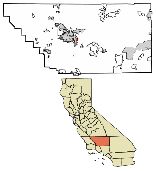
Trona
Position in California.
Coordinates: 35°48′54″N117°20′51″W / 35.81500°N 117.34750°W / 35.81500; -117.34750
Country Flag of the United States (23px).png  United States
State Flag of California.svg  California
County Inyo
Area
[1]
  Total9.297 sq mi (24.079 km2)
  Land9.296 sq mi (24.077 km2)
  Water0.001 sq mi (0.002 km2)  0.0083%
Elevation
[2]
1,693 ft (516 m)
Population
 (2020)
  Total11 [3]
Time zone UTC-8 (Pacific (PST))
  Summer (DST) UTC-7 (PDT)
GNIS feature ID2583168 [2]

Trona is a census-designated place in Inyo County, California, adjacent to the unincorporated community of Trona, San Bernardino County, California. The 2010 United States census reported Trona's population was 18.

Contents

Economy

Due to its remote nature, Trona's economy revolves around Marijuana cultivation [4] and the Trona Airport.

Demographics

At the 2010 census Trona had a population of 18. The population density was 1.9 people per square mile (0.73 people/km2). The racial makeup of Trona was 18 (100.0%) White, 0 (0.0%) African American, 0 (0.0%) Native American, 0 (0.0%) Asian, 0 (0.0%) Pacific Islander, 0 (0.0%) from other races, and 0 (0.0%) from two or more races. Hispanic or Latino of any race were 0 people (0.0%). [5]

The whole population lived in households, no one lived in non-institutionalized group quarters and no one was institutionalized.

There were 5 households, 3 (60.0%) had children under the age of 18 living in them, 4 (80.0%) were opposite-sex married couples living together, 0 (0%) had a female householder with no husband present, 0 (0%) had a male householder with no wife present. There were 0 (0%) unmarried opposite-sex partnerships, and 0 (0%) same-sex married couples or partnerships. 1 households (20.0%) were one person and 0 (0%) had someone living alone who was 65 or older. The average household size was 3.60. There were 4 families (80.0% of households); the average family size was 4.25.

The age distribution was 8 people (44.4%) under the age of 18, 0 people (0%) aged 18 to 24, 5 people (27.8%) aged 25 to 44, 5 people (27.8%) aged 45 to 64, and 0 people (0%) who were 65 or older. The median age was 30.0 years. For every 100 females, there were 80.0 males. For every 100 females age 18 and over, there were 100.0 males.

There were 6 housing units at an average density of 0.6 units per square mile (0.23 units/km2),of which 5 were occupied, 3 (50.0%) by the owners and 2 (40.0%) by renters. The homeowner vacancy rate was 0%; the rental vacancy rate was 0%. 12 people (66.7% of the population) lived in owner-occupied housing units and 6 people (33.3%) lived in rental housing units.

Related Research Articles

<span class="mw-page-title-main">Darwin, California</span> Census-designated place in California, United States

Darwin is an unincorporated mining community and Census-designated place in Inyo County, California, United States. It is located 22 miles (35 km) southeast of Keeler. The population was 43 at the 2010 census, down from 54 at the 2000 census.

<span class="mw-page-title-main">Dixon Lane-Meadow Creek, California</span> Census-designated place in California, United States

Dixon Lane-Meadow Creek is a census-designated place (CDP) in Inyo County, California, United States. The population was 2,645 at the 2010 census, down from 2,702 at the 2000 census.

<span class="mw-page-title-main">Mesa, California</span> Census-designated place in California, United States

Mesa is a census-designated place (CDP) in Inyo County, California, United States. The population was 251 at the 2010 census, up from 214 at the 2000 census.

<span class="mw-page-title-main">Round Valley, California</span> Census-designated place in California, United States

Round Valley is a census-designated place (CDP) in Inyo County, California, United States. Round Valley is located 7.5 miles (12 km) northeast of Mount Tom, at an elevation of 4692 feet. The population was 435 at the 2010 census, up from 278 at the 2000 census.

<span class="mw-page-title-main">Wilkerson, California</span> Census-designated place in California, United States

Wilkerson is a census-designated place (CDP) in Inyo County, California, United States. The population was 563 at the 2010 census, up from 562 at the 2000 census.

Sky Valley is a census-designated place in Riverside County, California. Sky Valley sits at an elevation of 994 feet (303 m). The 2010 United States census reported Sky Valley's population was 2,406.

<span class="mw-page-title-main">Searles Valley, California</span> Census-designated place in California, United States

Searles Valley is a census-designated place (CDP) in the Searles Valley of the Mojave Desert, in northwestern San Bernardino County, California.

Robinson Mill is a census-designated place in Butte County, California. It lies at an elevation of 2654 feet. Robinson Mill's population was 80 at the 2010 census.

Sunnyside is a census-designated place in Fresno County, California. It is located on the Southern Pacific Railroad 5 miles (8 km) north-northeast of Malaga, at an elevation of 328 ft (100 m). It is an eastern suburb of Fresno. At the 2010 census, Sunnyside's population was 4,235.

<span class="mw-page-title-main">Cherokee Strip, California</span> Census-designated place in California, United States

Cherokee Strip is a census-designated place in Kern County, California. It is located 2.5 miles (4 km) south-southeast of Shafter, at an elevation of 331 feet (101 m). The population was 206 at the 2010 census.

<span class="mw-page-title-main">Edmundson Acres, California</span> Census-designated place in California, United States

Edmundson Acres is a census-designated place in Kern County, California. It is located 1.25 miles (2 km) north-northeast of Arvin, at an elevation of 486 feet (148 m). Edmundson Acres' ZIP code is 93203. The population was 279 at the 2010 census.
<span class="mw-page-title-main">Fuller Acres, California</span> Census-designated place in California, United States

Fuller Acres is a census-designated place in Kern County, California. It is located 7.25 miles (12 km) southeast of downtown Bakersfield, at an elevation of 420 feet (128.02 m). The population was 991 at the 2010 census.

Paradise is an unincorporated community and census-designated place (CDP) that is the southernmost community in Mono County, California, United States. The population was 174 at the 2020 census.

Monument Hills is a census-designated place in Yolo County, California. Monument Hills sits at an elevation of 135 feet. The 2010 United States census reported Monument Hills's population was 1,542.

North Gate is a census-designated place in Contra Costa County, California. North Gate sits at an elevation of 253 feet (77 m). The 2010 United States census reported North Gate's population was 679.

Sunny Slopes is an unincorporated community and census-designated place (CDP) in Mono County, California, United States. It sits at an elevation of 7,198 feet (2,194 m). As of the 2020 census, the population was 139, down from 182 in 2010.

McGee Creek is an unincorporated community and census-designated place (CDP) in Mono County, California, United States. The community sits at an elevation of 7,723 feet (2,354 m), and as of the 2020 census the population was 45.

<span class="mw-page-title-main">Indio Hills, California</span> Census-designated place in California, United States

Indio Hills is a census-designated place in Riverside County, California. Indio Hills sits at an elevation of 1,017 feet (310 m). The 2010 United States census reported Indio Hills's population was 972.

Oasis is a census-designated place in the California county of Riverside. Oasis sits at an elevation of 141 feet (43 m) below sea level. The 2020 United States census reported Oasis's population was 4,468, down from 6,890 in 2010.

Sugarloaf Village is a census-designated place (CDP) in Tulare County, California. Sugarloaf Village sits at an elevation of 5,171 feet (1,576 m). The 2020 United States census reported Sugarloaf Village's population was 7, down from 10 at the 2010 census.

References

  1. "2010 Census Gazetteer Files - Places - California". United States Census Bureau . Retrieved March 26, 2015.
  2. 1 2 U.S. Geological Survey Geographic Names Information System: Trona, Inyo County, California
  3. "Explore Census Data".
  4. "September 22,2021 Agenda, County of Inyo Planning Commission" (PDF). Inyo County Planning Commission. Inyo County. Retrieved 22 August 2022.
  5. "2010 Census Interactive Population Search: CA - Trona CDP". U.S. Census Bureau. Archived from the original on July 15, 2014. Retrieved July 12, 2014.