The Mississippi River is the second-longest river and chief river of the second-largest drainage system on the North American continent, second only to the Hudson Bay drainage system. From its traditional source of Lake Itasca in northern Minnesota, it flows generally south for 2,320 miles (3,730 km) to the Mississippi River Delta in the Gulf of Mexico. With its many tributaries, the Mississippi's watershed drains all or parts of 32 U.S. states and two Canadian provinces between the Rocky and Appalachian mountains. The main stem is entirely within the United States; the total drainage basin is 1,151,000 sq mi (2,980,000 km2), of which only about one percent is in Canada. The Mississippi ranks as the fourth-longest river and fifteenth-largest river by discharge in the world. The river either borders or passes through the states of Minnesota, Wisconsin, Iowa, Illinois, Missouri, Kentucky, Tennessee, Arkansas, Mississippi, and Louisiana.

A swamp is a forested wetland. Swamps are considered to be transition zones because both land and water play a role in creating this environment. Swamps vary in size and are located all around the world. The water of a swamp may be fresh water, brackish water, or seawater. Freshwater swamps form along large rivers or lakes where they are critically dependent upon rainwater and seasonal flooding to maintain natural water level fluctuations. Saltwater swamps are found along tropical and subtropical coastlines. Some swamps have hammocks, or dry-land protrusions, covered by aquatic vegetation, or vegetation that tolerates periodic inundation or soil saturation. The two main types of swamp are "true" or swamp forests and "transitional" or shrub swamps. In the boreal regions of Canada, the word swamp is colloquially used for what is more correctly termed a bog, fen, or muskeg. Some of the world's largest swamps are found along major rivers such as the Amazon, the Mississippi, and the Congo.
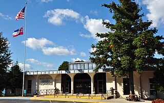
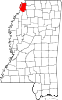
Tishomingo County is a county located in the northeastern corner of the U.S. state of Mississippi. As of the 2010 census, the population was 19,593. Its county seat is Iuka.

Mississippi County is a county located in the U.S. state of Arkansas. As of the 2010 census, the population was 46,480. There are two county seats, Blytheville and Osceola. The county was formed on November 1, 1833, and named for the Mississippi River which borders the county to the east. Mississippi County is part of the First Congressional District in Arkansas. The Mississippi County Judge is John Alan Nelson.

The Midwestern United States, often referred to simply as the Midwest, is one of four census regions of the United States Census Bureau. It occupies the northern central part of the United States. It was officially named the North Central Region by the Census Bureau until 1984. It is located between the Northeastern United States and the Western United States, with Canada to its north and the Southern United States to its south.

Horseshoe Lake is a town in Crittenden County, Arkansas, United States. The population was 292 at the 2010 census.
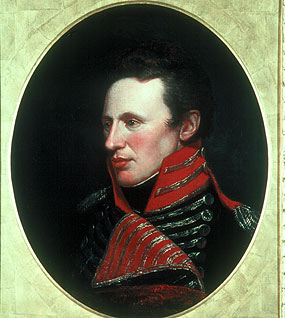
Zebulon Montgomery Pike was an American brigadier general and explorer for whom Pikes Peak in Colorado was named. As a U.S. Army officer he led two expeditions under authority of President Thomas Jefferson through the new Louisiana Purchase territory, first in 1805–1806 to reconnoiter the upper northern reaches of the Mississippi River, and then in 1806–1807 to explore the Southwest to the fringes of the northern Spanish-colonial settlements of New Mexico and Texas. Pike's expeditions coincided with other Jeffersonian expeditions, including the Lewis and Clark Expedition (1804–1806) and the Thomas Freeman and Peter Custis expedition up the Red River (1806).

The Northwest Angle, known simply as the Angle by locals, and coextensive with Angle Township, is a part of northern Lake of the Woods County, Minnesota. Except for minor surveying errors, it is the only place in the contiguous United States north of the 49th parallel, which forms the border between the U.S. and Canada from the Northwest Angle westward to the Strait of Georgia. The land area of the Angle is separated from the rest of Minnesota by Lake of the Woods, but shares a land border with Canada. It is one of only six non-island locations in the 48 contiguous states that are practical exclaves of the U.S. It is the northernmost township in Minnesota and contains the northernmost point in the contiguous 48 states. The unincorporated community of Angle Inlet is in the Northwest Angle.

The headwaters of a river or stream is the farthest place in that river or stream from its estuary or downstream confluence with another river, as measured along the course of the river. It is also known as a river's source.

The Treaty of La Pointe may refer to either of two treaties made and signed in La Pointe, Wisconsin between the United States and the Ojibwe (Chippewa) Native American peoples. In addition, the Isle Royale Agreement, an adhesion to the first Treaty of La Pointe, was made at La Pointe.

Chippewa National Forest is a National Forest located in north central Minnesota, United States, in the counties of Itasca, Cass and Beltrami. Forest headquarters are located in Cass Lake, Minnesota. There are local ranger district offices in Blackduck, Deer River and Walker.
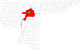
The Memphis–Forrest City Combined Statistical Area, TN–MS–AR (CSA) is the commercial and cultural hub of The Mid-South or Ark-Miss-Tenn. The census defined combined statistical area covers ten counties in three states – Tennessee, Mississippi, and Arkansas. As of census 2010 the MSA had a population of 1,324,108. The Forrest City Micropolitan area was added to the Memphis area in 2012 to form the Memphis–Forrest City Combined Statistical area and had a population of 1,369,548 according to census estimates. The greater Mid-South area as a whole has a population of 2.4 million according to 2013 census estimates. This area is covered by Memphis local news channels and includes the Missouri Bootheel, Northeast Arkansas, West Tennessee, and North Mississippi.
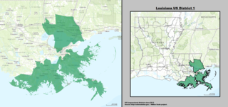
Louisiana's 1st congressional district is a congressional district in the U.S. state of Louisiana. The district comprises land from the northern shore of Lake Pontchartrain south to the Mississippi River delta.

The Upper Mississippi River National Wildlife and Fish Refuge is a 240,000-acre (970 km2), 261-mile long (420 km) National Wildlife Refuge located in and along the Upper Mississippi River. It runs from Wabasha, Minnesota in the north to Rock Island, Illinois in the south.

The United States Census of 1800 was the second Census conducted in the United States. It was conducted on August 4, 1800.
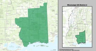
Mississippi's 4th congressional district covers the southeastern region of the state. It includes all of Mississippi's Gulf Coast, stretching ninety miles between the Alabama border to the east and the Louisiana border to the west, and extends north into the Pine Belt region. It includes three of Mississippi's four most heavily populated cities: Gulfport, Biloxi, and Hattiesburg. Other major cities within the district include Bay St. Louis, Laurel, and Pascagoula.

Mississippi is a state in the Deep South region of the United States. Mississippi is the 32nd largest and 34th-most populous of the 50 U.S. states. Mississippi is bordered to the north by Tennessee, to the east by Alabama, to the south by the Gulf of Mexico, to the southwest by Louisiana, and to the northwest by Arkansas. Mississippi's western boundary is largely defined by the Mississippi River. Jackson is both the state's capital and largest city. Greater Jackson, with an estimated population of 580,166 in 2018, is the most-populous metropolitan area in Mississippi and the 95th-most populous in the United States.

Elvis Presley Lake is a lake in Lee County, Mississippi, United States.