Ludington, Wisconsin

Last updated

Town of Ludington, Wisconsin
WIMap-doton-Ludington.png
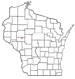
Location of Ludington
Ludington, Wisconsin map.png
Location of Ludington in Eau Claire County
Coordinates: 44°47′36″N91°10′33″W / 44.79333°N 91.17583°W / 44.79333; -91.17583
Country Flag of the United States.svg  United States
State Flag of Wisconsin.svg  Wisconsin
County Eau Claire
Area
  Total46.0 sq mi (119.0 km2)
  Land45.8 sq mi (118.5 km2)
  Water0.2 sq mi (0.5 km2)
Elevation
[1]
1,030 ft (314 m)
Population
 (2000)
  Total998
  Density21.8/sq mi (8.4/km2)
Time zone UTC-6 (Central (CST))
  Summer (DST) UTC-5 (CDT)
Area code(s) 715 & 534
FIPS code 55-46275 [2]
GNIS feature ID1583609 [1]

Ludington is a town in Eau Claire County, Wisconsin, United States. The population was 1,023 at the 2010 census.

Contents

Geography

According to the United States Census Bureau, the town has a total area of 46.0 square miles (119.1 km2), of which 45.8 square miles (118.6 km2) is land and 0.2 square miles (0.5 km2) is water.

Demographics

Historical population
CensusPop.Note
1990 906
2000 99810.2%
2010 1,0636.5%
2020 (est.)1,084 [3] 2.0%

As of the census [2] of 2000, there were 998 people, 360 households, and 293 families residing in the town. The population density was 21.8 people per square mile (8.4/km2). There were 407 housing units at an average density of 8.9 per square mile (3.4/km2). The racial makeup of the town was 98.50% White, 0.10% African American, 0.20% Native American, 0.90% Asian, and 0.30% from two or more races. Hispanic or Latino of any race were 0.20% of the population.

There were 360 households, out of which 35.3% had children under the age of 18 living with them, 72.2% were married couples living together, 5.6% had a female householder with no husband present, and 18.6% were non-families. 14.2% of all households were made up of individuals, and 5.8% had someone living alone who was 65 years of age or older. The average household size was 2.77 and the average family size was 3.04.

The population was 26.3% under the age of 18, 7.6% from 18 to 24, 29.6% from 25 to 44, 26.1% from 45 to 64, and 10.5% who were 65 years of age or older. The median age was 38 years. For every 100 females, there were 106.6 males. For every 100 females age 18 and over, there were 102.2 males.

The median income for a household in the town was $42,396, and the median income for a family was $44,750. Males had a median income of $32,500 versus $21,974 for females. The per capita income for the town was $16,291. About 3.4% of families and 4.9% of the population were below the poverty line, including 7.2% of those under age 18 and none of those age 65 or over.

Related Research Articles

<span class="mw-page-title-main">Blaine, Maine</span> Town in the state of Maine, United States

Blaine is a town in Aroostook County, Maine, United States. The population was 667 at the 2020 census. It was known as Alva prior to incorporation in 1874, when it was renamed in honor of James G. Blaine, then Speaker of the U.S. House of Representatives. According to local history, Blaine offered to donate a large bell for the tower of the town's new meeting hall, if the citizens would rename the town after him. The town's name was changed, but Blaine never donated a bell. The building still stands on the north end of town, on Route 1.

<span class="mw-page-title-main">Hammond, Maine</span> Town in the state of Maine, United States

Hammond is a town in Aroostook County, Maine, United States. The population was 91 at the 2020 census.

<span class="mw-page-title-main">New Sharon, Maine</span> Town in the state of Maine, United States

New Sharon is a town in Franklin County, Maine, incorporated in 1794. The population was 1,458 at the 2020 census. The town is roughly bisected by the Sandy River, a tributary of the Kennebec River.

<span class="mw-page-title-main">Gouldsboro, Maine</span> Town in the state of Maine, United States

Gouldsboro is a town and municipality in Hancock County, Maine, United States on the Schoodic Peninsula. The town was named for Robert Gould, a landholder in the town. The town has many historically separate fishing villages, summer colonies and communities, including Birch Harbor, Prospect Harbor, South Gouldsboro, West Gouldsboro, Summer Harbor, Wonsqueak Harbor, Bunker's Harbor, Chicken Mill, Jones' Pond, Westbay, and Corea. The population was 1,703 at the 2020 census.

<span class="mw-page-title-main">Hartford, Maine</span> Town in the state of Maine, United States

Hartford is a town in Oxford County, Maine, United States. Hartford is included in the Lewiston-Auburn, Maine metropolitan New England City and Town Area. The population was 1,203 at the 2020 census.

Winn is a town in Penobscot County, Maine, United States, on the east bank of the Penobscot River. The town was named for John M. Winn, an early landholder. The population was 399 at the 2020 census.

Princeton is a town in Washington County, Maine, United States. The town was named after Princeton, Massachusetts. The population was 745 at the 2020 census.

<span class="mw-page-title-main">Amber Township, Michigan</span> Civil township in Michigan, United States

Amber Township is a civil township of Mason County in the U.S. state of Michigan. As of the 2020 census, the township population was 2,529.

<span class="mw-page-title-main">Fountain, Michigan</span> Village in Michigan, United States

Fountain is a village in Mason County in the U.S. state of Michigan. The population was 170 at the 2020 census. The village is within Sherman Township.

<span class="mw-page-title-main">Free Soil, Michigan</span> Village in Michigan, United States

Free Soil is a village in Mason County in the U.S. state of Michigan. The population was 158 at the 2020 census. The village is located within Free Soil Township.

<span class="mw-page-title-main">Hamlin Township, Mason County, Michigan</span> Civil township in Michigan, United States

Hamlin Township is a civil township of Mason County in the U.S. state of Michigan. The population was 3,711 at the 2020 census, up from 3,408 in 2010.
<span class="mw-page-title-main">Pere Marquette Charter Township, Michigan</span> Charter township in Michigan, United States

Pere Marquette Charter Township is a charter township of Mason County in the U.S. state of Michigan. The population was 2,416 at the 2020 census.

<span class="mw-page-title-main">Sherman Township, Mason County, Michigan</span> Civil township in Michigan, United States

Sherman Township is a civil township of Mason County in the U.S. state of Michigan. The population was 1,127 at the 2020 census.

<span class="mw-page-title-main">Syracuse, Ohio</span> Village in Ohio, United States

Syracuse is a village in Meigs County, Ohio, United States, along the Ohio River. The population was 781 at the 2020 census.

<span class="mw-page-title-main">Belmont, West Virginia</span> Town in West Virginia, United States

Belmont is a town in Pleasants County, West Virginia, United States. It is part of the Parkersburg–Vienna metropolitan area. The population was 872 at the 2020 census. Belmont was incorporated on April 19, 1946, by the Circuit Court of Pleasants County. The city was named for the beautiful hills in the area.

<span class="mw-page-title-main">Newburg, West Virginia</span> Town in West Virginia, United States

Newburg is a town in western Preston County, West Virginia, United States. The population was 275 at the 2020 census. It is part of the Morgantown metropolitan area.

<span class="mw-page-title-main">Middlebourne, West Virginia</span> Town in West Virginia, United States

Middlebourne is a town and the county seat of Tyler County, West Virginia, United States. The population was 715 at the 2020 census.

<span class="mw-page-title-main">Neva, Wisconsin</span> Town in Wisconsin, United States

Neva is a town in Langlade County, Wisconsin, United States. The population was 902 at the 2010 census, down from 994 at the 2000 census. The unincorporated communities of Deerbrook, Kempster, Neva, and Neva Corners are located in the town.
<span class="mw-page-title-main">Maple Grove, Shawano County, Wisconsin</span> Town in Wisconsin, United States

Maple Grove is a town in Shawano County, Wisconsin, United States. The population was 1,045 at the 2000 census. The unincorporated communities of Hofa Park, Laney, and Rose Lawn are located in the town. The unincorporated communities of Angelica, Frazer Corners, and Pittsfield are also located partially in the town.

<span class="mw-page-title-main">Wheatland, Vernon County, Wisconsin</span> Town in Vernon County, Wisconsin, United States

Wheatland is a town in Vernon County, Wisconsin, United States. The population was 533 at the 2000 census. The unincorporated communities of Red Mound, and Victory are located in Wheatland.
References

  1. 1 2 "Town of Ludington". Geographic Names Information System . United States Geological Survey, United States Department of the Interior . Retrieved April 5, 2023.
  2. 1 2 "U.S. Census website". United States Census Bureau . Retrieved January 31, 2008.
  3. "County Population Totals: 2010-2020" . Retrieved June 22, 2021.