Lumpkin Hill

Last updated
Lumpkin Hill

GA 20 and Lumpkin Hill, Rome, GA Mar 2018.jpg

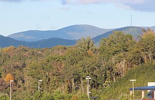
Georgia State Route 20 goes over the summit of Lumpkin Hill
Highest point
Elevation 640 ft (200 m) [1]
Coordinates 34°15′32″N85°09′59″W / 34.2589824°N 85.1663393°W / 34.2589824; -85.1663393 Coordinates: 34°15′32″N85°09′59″W / 34.2589824°N 85.1663393°W / 34.2589824; -85.1663393 [2] [3]
Geography
USA Georgia location map.svg
Red triangle with thick white border.svg
Lumpkin Hill
Location of Lumpkin Hill in Georgia
Location Rome, Georgia, U.S.
Topo map USGS Rome North, GA
Climbing
Easiest route Drive

Lumpkin Hill is a summit in Rome, Georgia. [2] With an elevation of 640 feet (200 m), Lumpkin Hill is the 914th highest summit in the state of Georgia. [1] The hill is considered to be one of the Seven Hills of Rome, Georgia. [4] [5]

Summit A point on a surface that is higher in elevation than all points immediately adjacent to it, in topography

A summit is a point on a surface that is higher in elevation than all points immediately adjacent to it. The topographic terms acme, apex, peak, and zenith are synonymous.

Rome, Georgia City in Georgia, United States

Rome is the largest city in the county seat of Floyd County, Georgia, United States. Located in the foothills of the Appalachian Mountains, it is the principal city of the Rome, Georgia, Metropolitan Statistical Area, which encompasses all of Floyd County. At the 2010 census, the city had a population of 36,303. It is the largest city in Northwest Georgia and the 19th largest city in the state.

The summit was named for John Henry Lumpkin, who is also buried on the hill. [6] [4] In 1956, Lumpkin Hill's peak was leveled during the construction of Turner McCall Boulevard. [4]

John Henry Lumpkin was an American politician, lawyer and jurist.

Georgia State Route 20 highway in Georgia

State Route 20 (SR 20) is a 165.345-mile-long (266.097 km) state highway roughly in the shape of a capital J rotated ninety degrees to the left, which travels through portions of Floyd, Bartow, Cherokee, Forsyth, Gwinnett, Walton, Rockdale, Newton, and Henry counties in the northwestern and north-central parts of the U.S. state of Georgia. Its counterclockwise, or western terminus is at the Alabama state line in Floyd County, and its clockwise, or eastern terminus occurs at its interchange with Lower Woolsey Road southwest of Hampton in Henry County south-southeast of the Atlanta Motor Speedway.

Related Research Articles

Lumpkin County, Georgia County in the United States

Lumpkin County is a county located in the north central portion of the U.S. state of Georgia. As of the 2010 census, the population was 29,966. Its county seat is Dahlonega.

Dahlonega, Georgia City in Georgia, United States

The city of Dahlonega is the county seat of Lumpkin County, Georgia, United States. As of the 2010 census, the city had a population of 5,242.

Wilson Lumpkin American politician

Wilson Lumpkin was an American planter, attorney, and politician. He served two terms as the governor of Georgia, from 1831 to 1835, in the period of Indian Removal of the Creek and Cherokee peoples to Indian Territory to make way for development of their lands by European Americans. He also served in the state house, and as a United States Representative and US Senator. He ran from Clarke County, Georgia, in the northeast part of the state.

Homer V. M. Miller American politician

Homer Virgil Milton Miller was an American physician and politician from the U.S. state of Georgia, who practiced medicine for the Confederacy in the American Civil War and served as a U.S. Senator from Georgia for seven days in 1871.

Three Sisters (Georgia) mountain near Dahlonega, Lumpkin County, Georgia, USA

Three Sisters Mountain is a mountain near Dahlonega, Lumpkin County, Georgia with a trio of peaks known locally as Rattlesnake, Wildcat and McBrayer. The middle summit is the highest with an elevation of 2,131 feet (650 m).

Levelland Mountain mountain in United States of America

Levelland Mountain is the highest point in the Raven Cliffs Wilderness in Lumpkin and Union counties, Georgia. The mountain is traversed by the Appalachian Trail and is in the Chattahoochee National Forest. The summit is the tenth-highest peak in the Union County.

Rich Mountain (Georgia) Mountain in the US State of Georgia

Rich Mountain, elevation 4,040 feet (1,230 m), is the highest point in the Rich Mountain Wilderness of the Chattahoochee National Forest in Gilmer County, Georgia. It is the second-highest peak in Gilmer County; only Big Bald Mountain is taller, with its summit at 4,081 feet (1,244 m).

Big Bald Mountain Mountain in the US State of Georgia

At 4,075 feet (1,242 m), Big Bald Mountain, is the highest peak in Gilmer County, Georgia. It is also located within the boundaries of the Chattahoochee National Forest.

Big John Dick Mountain summit in Fannin County, Georgia, in the United States

Big John Dick Mountain is a summit in Fannin County, Georgia, in the United States. With an elevation of 3,278 feet (999 m), Big John Dick Mountain is the 196th tallest mountain in Georgia.

Horseleg Mountain

Horseleg Mountain is a summit in Floyd County, Georgia, in the United States. With an elevation of 1,322 feet (403 m), Horseleg Mountain is the 735th highest summit in the state of Georgia.

Blossom Hill (Georgia) mountain in United States of America

Blossom Hill is a summit in Rome, Georgia. With an elevation of 784 feet (239 m), Blossom Hill is the 901st highest summit in the state of Georgia. It is considered to be one of the Seven Hills of Rome, Georgia. Jackson Hill is located about 0.3 miles (0.48 km) south of the summit.

Jackson Hill (Georgia) mountain in Georgia, United States of America

Jackson Hill is a summit in Rome, Georgia. With an elevation of 751 feet (229 m), Jackson Hill is the 905th highest summit in the state of Georgia. The hill considered to be one of the Seven Hills of Rome, Georgia.

Old Shorter Hill

Old Shorter Hill is a summit in Rome, Georgia. With an elevation of 676 feet (206 m), Old Shorter Hill is the 910th highest summit in the US state of Georgia. It is considered to be one of the Seven Hills of Rome, Georgia.

Snodgrass Hill is a summit in Walker County, Georgia. With an elevation of 896 feet (273 m), Snodgrass Hill is the 886th highest summit in the state of Georgia.

Chinese Peak (Idaho)

Chinese Peak is a summit in Bannock County, Idaho, in the United States. This peak is the highest point in the portion of the Portneuf Range called the Pocatello Range. With an elevation of 6,791 feet (2,070 m), Chinese Peak is the 1069th highest summit in the state of Idaho. The peak is a fire lookout site and a road/bike trail leads to the top.

Louvale, Georgia Unincorporated community in Georgia, United States

Louvale is an unincorporated community in Stewart County, Georgia, United States. The community is located along U.S. Route 27, 8.7 miles (14.0 km) north of Lumpkin. Louvale has a post office with ZIP code 31814.

References

  1. 1 2 "Lumpkin Hill". Peakery.com. Retrieved 25 April 2015.
  2. 1 2 U.S. Geological Survey Geographic Names Information System: Lumpkin Hill
  3. United States Geological Survey (March 19, 2018). North Rome, GA quadrangle (Topographic map). Reston, VA: United States Geological Survey. Retrieved March 19, 2018 via TopoQuest.
  4. 1 2 3 Wilson, CC. The Seven Hills of Rome. RomeGeorgia.com. 23 February 2002. Retrieved 17 March 2018.
  5. Denmon, Shirley. The Enchanted Land Eighth Hill. (2012). pp. 5. ISBN   9781452089553
  6. "Floyd County". Calhoun Times. September 1, 2004. p. 76. Retrieved 24 April 2015.