Madison (village), New York

Last updated

Madison, New York
Madison Central School, Madison, NY, July 2023.jpg
Madison Central School in the village
USA New York location map.svg
Red pog.svg
Madison, New York
Location within the state of New York
Coordinates: 42°54′3″N75°30′55″W / 42.90083°N 75.51528°W / 42.90083; -75.51528
Country United States
State New York
County Madison
Government
  MayorBarbara Clark
Area
[1]
  Total0.48 sq mi (1.24 km2)
  Land0.48 sq mi (1.24 km2)
  Water0.00 sq mi (0.00 km2)
Elevation
1,204 ft (367 m)
Population
 (2020)
  Total311
  Density651.99/sq mi (251.49/km2)
Time zone UTC-5 (Eastern (EST))
  Summer (DST) UTC-4 (EDT)
ZIP code
13402
Area code 315
FIPS code 36-44424
GNIS feature ID0956252

Madison is a village in Madison County, New York, United States. The population was 305 at the 2010 census. The village and its town are named after President James Madison.

Contents

The Village of Madison is in the central part of the Town of Madison on US Route 20.

History

The village was incorporated in 1816. Located on NY Route 20, Madison was a busy thoroughfare for east-west travelers and featured a hotel and resort on Madison Lake. Much of Madison was owned by businessman G.W. Hinman. Many visitors came from the nearby hamlet of Solsville, where the Chenengo Canal and the railroad both had stations. Madison is most famous for the Madison-Bouckville Antique Show, which takes place in August annually and sees over 1,000 antique dealers and tens of thousands of buyers traveling to Madison to find rare and unique items.

In 2000, Solsville, a half-mile north of Madison, became part of the town of Madison. Solsville is known for its historic Solsville Hotel, which was at one point the town post office, saloon, and ballroom, as well as the old canal house.

Notable person

Geography

Madison is located at 42°54′2″N75°30′54″W / 42.90056°N 75.51500°W / 42.90056; -75.51500 (42.900775, -75.515153). [2]

According to the United States Census Bureau, the village has a total area of 0.5 square mile (1.3 km2), all land.

Demographics

Historical population
CensusPop.Note
1880 320
1890 39021.9%
1900 321−17.7%
1910 309−3.7%
1920 265−14.2%
1930 2878.3%
1940 3004.5%
1950 33511.7%
1960 327−2.4%
1970 38618.0%
1980 3962.6%
1990 316−20.2%
2000 315−0.3%
2010 305−3.2%
2020 3112.0%
U.S. Decennial Census [3]

As of the census [4] of 2000, there were 315 people, 138 households, and 77 families residing in the village. The population density was 626.5 inhabitants per square mile (241.9/km2). There were 151 housing units at an average density of 300.3 per square mile (115.9/km2). The racial makeup of the village was 99.68% White and 0.32% Asian. Hispanic or Latino of any race were 0.63% of the population.

There were 138 households, out of which 26.1% had children under the age of 18 living with them, 44.2% were married couples living together, 9.4% had a female householder with no husband present, and 43.5% were non-families. 36.2% of all households were made up of individuals, and 14.5% had someone living alone who was 65 years of age or older. The average household size was 2.28 and the average family size was 3.01.

In the village, the population was spread out, with 24.4% under the age of 18, 7.0% from 18 to 24, 29.2% from 25 to 44, 23.2% from 45 to 64, and 16.2% who were 65 years of age or older. The median age was 38 years. For every 100 females, there were 87.5 males. For every 100 females age 18 and over, there were 83.1 males.

The median income for a household in the village was $27,250, and the median income for a family was $37,708. Males had a median income of $28,125 versus $21,786 for females. The per capita income for the village was $16,960. About 9.9% of families and 12.9% of the population were below the poverty line, including 7.6% of those under age 18 and 3.7% of those age 65 or over.

Related Research Articles

<span class="mw-page-title-main">Nemaha, Iowa</span> City in Iowa, United States

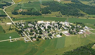
Nemaha is a city in Sac County, Iowa, United States. The population was 66 at the time of the 2020 census.

Berlin Township is a civil township of Ionia County in the U.S. state of Michigan. As of the 2000 census, the township population was 2,787.

<span class="mw-page-title-main">Westerlo, New York</span> Town in New York, United States

Westerlo is a town in Albany County, New York, United States. The population was 3,194 at the 2020 census.

Constableville is a village in Lewis County, New York, United States. The population was 242 at the 2010 census. The village is named after William Constable, the son of an early landowner.

<span class="mw-page-title-main">Morrisville, New York</span> Village in New York, United States

Morrisville is a village in Madison County, New York, United States. The population was 2,199 at the 2010 census. The village is named after its founder, Thomas Morris.

<span class="mw-page-title-main">Munnsville, New York</span> Village in New York, United States

Munnsville is a village located in the Town of Stockbridge in Madison County, New York, United States. The population was 474 at the 2010 census. The village is named for an early settler, Asa Munn, and located on New York State Route 46.

Smithfield is a town in Madison County, New York, United States. Administrative offices are in the hamlet of Peterboro. The town and hamlet both are named after Peter Smith, an original land owner. As of the 2010 Census, the population was 1,288.

Stockbridge is a town in Madison County, New York, United States. The population was 2,103 at the 2010 census. The name is derived from a group of Native Americans.

Wampsville is a village located inside the Town of Lenox in Madison County, New York, United States. The population was 543 as of the 2010 census. It is the county seat of Madison County.

<span class="mw-page-title-main">Oriskany Falls, New York</span> Village in New York, United States

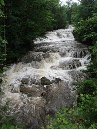
Oriskany Falls is a village in Oneida County, New York, United States. The population was 732 at the 2010 census. The name is derived from a waterfall on a nearby stream.

<span class="mw-page-title-main">Sangerfield, New York</span> Town in New York, United States

Sangerfield is a town in Oneida County, New York, United States. The population was 2,561 at the 2010 census. The town is named after Jedediah Sanger, an early settler.

<span class="mw-page-title-main">Friendly, West Virginia</span> Town in West Virginia, United States

Friendly is a town in Tyler County, West Virginia, United States. The population was 100 at the 2020 census.

<span class="mw-page-title-main">Friesland, Wisconsin</span> Village in Wisconsin, United States

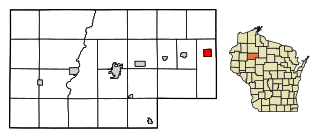
Friesland is a village in Columbia County, Wisconsin, United States. The population was 320 at the 2020 census. It is part of the Madison Metropolitan Statistical Area.

<span class="mw-page-title-main">Hollandale, Wisconsin</span> Village in Wisconsin, United States

Hollandale is a village in Iowa County, Wisconsin, United States. The population was 306 at the 2020 census. It is part of the Madison Metropolitan Statistical Area.

<span class="mw-page-title-main">Earlville, New York</span> Village in New York, United States

Earlville is a village in New York state bisected by two counties: Madison County and Chenango County, United States. The population was 774 as per the 2020 Decennial census, a decrease from the 872 reported in the 2010 census. The village is named after Jonas Earl, a canal commissioner.

Bridgeport is a hamlet located partly in the town of Sullivan in Madison County, New York, United States and partly in the town of Cicero in Onondaga County. The population was 1,490 at the 2010 census.

<span class="mw-page-title-main">DeRuyter (village), New York</span> Village in New York, United States

DeRuyter is a village located in the Town of DeRuyter in Madison County, New York, United States. The population was 558 at the 2010 census. The village and town are named after Michiel Adriaenszoon de Ruyter, a famous admiral in the Dutch navy.

<span class="mw-page-title-main">Madison, New York</span> Town in New York, United States

Madison is a town in Madison County, New York, United States. The population was 3,008 at the 2010 census.

<span class="mw-page-title-main">Bridgewater (CDP), New York</span> Hamlet and CDP in New York, United States

Bridgewater is a hamlet in Oneida County, New York, United States. The population was 470 at the 2010 census.

<span class="mw-page-title-main">Hawkins, Wisconsin</span> Village in Wisconsin, United States

Hawkins is a village in Rusk County, Wisconsin, United States. The population was 305 at the 2010 census. The village is located within the Town of Hawkins.

References

  1. "ArcGIS REST Services Directory". United States Census Bureau. Retrieved September 20, 2022.
  2. "US Gazetteer files: 2010, 2000, and 1990". United States Census Bureau. February 12, 2011. Retrieved April 23, 2011.
  3. "Census of Population and Housing". Census.gov. Retrieved June 4, 2015.
  4. "U.S. Census website". United States Census Bureau . Retrieved January 31, 2008.