Munnsville, New York

Last updated

Munnsville, New York
Stockbridge Falls Munnsville NY Jun 11.jpg
Stockbridge Falls, June 2011
USA New York location map.svg
Red pog.svg
Munnsville, New York
Location within the state of New York
Coordinates: 42°58′36″N75°35′18″W / 42.97667°N 75.58833°W / 42.97667; -75.58833
Country United States
State New York
County Madison
Area
[1]
  Total0.88 sq mi (2.27 km2)
  Land0.88 sq mi (2.27 km2)
  Water0.00 sq mi (0.00 km2)
Elevation
659 ft (201 m)
Population
 (2020)
  Total454
  Density518.26/sq mi (200.19/km2)
Time zone UTC-5 (Eastern (EST))
  Summer (DST) UTC-4 (EDT)
ZIP code
13409
Area code 315
FIPS code 36-49220
GNIS feature ID2391001

Munnsville is a village located in the Town of Stockbridge in Madison County, New York, United States. The population was 474 at the 2010 census. The village is named for an early settler, Asa Munn, and located on New York State Route 46.

Contents

History

Asa Munn opened a mercantile business in the community circa 1817.

In 1990 the village received national media attention and interviews by Connie Chung when a local dairy farmer, Delbert Ward, allegedly murdered his brother William Ward by suffocation. [2] Delbert was found not guilty at trial. In 1992, this incident was examined in the documentary Brother's Keeper .

Munnsville became a world-renowned racing location for skateboarding because of the Madison County Gravity Festival, which began in 2002. Skateboarders from all over North America and Europe descend on the town for the last weekend of July and race their skateboards at speeds up to 95 km/h.

The former Munnsville depot of the defunct (March 29, 1957) New York, Ontario & Western Railway is now a private residence, occupied by NYO&W historian and author John Taibi. [3]

Notable people

Munnsville was the final home of poet Hayden Carruth.

Munnsville is the birthplace of Bill Horr, who won silver and bronze at the 1908 Olympics.

Geography

Munnsville is located at 42°58′36″N75°35′18″W / 42.97667°N 75.58833°W / 42.97667; -75.58833 (42.976597, -75.588236). [4]

According to the United States Census Bureau, the village has a total area of 0.9 square miles (2.3 km2), all land.

Demographics

Historical population
CensusPop.Note
1870 313
1880 3295.1%
1920 377
1930 345−8.5%
1940 3573.5%
1950 41215.4%
1960 391−5.1%
1970 43511.3%
1980 49914.7%
1990 438−12.2%
2000 437−0.2%
2010 4748.5%
2020 454−4.2%
U.S. Decennial Census [5]

As of the census [6] of 2000, there were 437 people, 166 households, and 118 families residing in the village. The population density was 506.6 inhabitants per square mile (195.6/km2). There were 176 housing units at an average density of 204.0 per square mile (78.8/km2). The racial makeup of the village was 98.40% White, 0.46% African American, 0.23% Native American, and 0.92% from two or more races. Hispanic or Latino of any race were 0.69% of the population.

There were 166 households, out of which 34.3% had children under the age of 18 living with them, 53.0% were married couples living together, 12.7% had a female householder with no husband present, and 28.9% were non-families. 22.9% of all households were made up of individuals, and 12.7% had someone living alone who was 65 years of age or older. The average household size was 2.60 and the average family size was 3.04.

In the village, the population was spread out, with 26.5% under the age of 18, 8.5% from 18 to 24, 30.2% from 25 to 44, 23.1% from 45 to 64, and 11.7% who were 65 years of age or older. The median age was 36 years. For every 100 females, there were 92.5 males. For every 100 females age 18 and over, there were 93.4 males.

The median income for a household in the village was $35,000, and the median income for a family was $36,250. Males had a median income of $35,417 versus $21,250 for females. The per capita income for the village was $16,657. About 9.7% of families and 14.8% of the population were below the poverty line, including 15.2% of those under age 18 and 16.1% of those age 65 or over.

Related Research Articles

<span class="mw-page-title-main">St. Jacob, Illinois</span> Village in Illinois, United States

St. Jacob or Saint Jacob is a village in Madison County, Illinois, United States. The population was 1,358 at the 2020 census, up from 1,098 in 2010.

<span class="mw-page-title-main">Monson Center, Massachusetts</span> Census-designated place in Massachusetts, United States

Monson Center is a census-designated place (CDP) in the town of Monson in Hampden County, Massachusetts, United States. The population was 2,107 at the 2010 census, out of a total 8,560 people in the town. It is part of the Springfield, Massachusetts Metropolitan Statistical Area.

<span class="mw-page-title-main">Landfall, Minnesota</span> City in Minnesota, United States

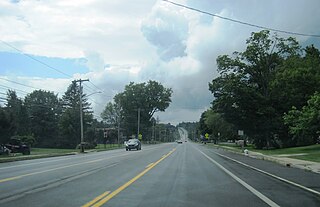
Landfall is a city in Washington County, Minnesota, United States. The population was 686 at the 2010 census and is the smallest community in Washington County in terms of area. It lies on the eastern shore of Tanner's Lake on Interstate 94.

<span class="mw-page-title-main">Scotsdale, Missouri</span> Village in Missouri, United States

Scotsdale is a village in Jefferson County, Missouri, United States. The population was 222 at the 2010 census.

<span class="mw-page-title-main">Morrisville, New York</span> Village in New York, United States

Morrisville is a village in Madison County, New York, United States. The population was 2,199 at the 2010 census. The village is named after its founder, Thomas Morris.

<span class="mw-page-title-main">Nelson, New York</span> Town in New York, United States

Nelson is a town in Madison County, New York, United States. It is an interior town, located in the southwestern part of the county. The population was 1,890 at the 2020 census. The town was named after Horatio Nelson, the English naval hero.

Stockbridge is a town in Madison County, New York, United States. The population was 2,103 at the 2010 census. The name is derived from a group of Native Americans.

<span class="mw-page-title-main">Oriskany Falls, New York</span> Village in New York, United States

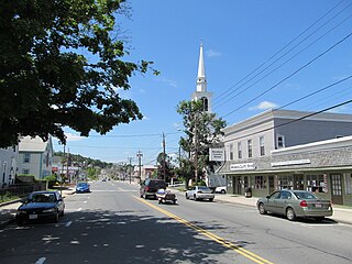
Oriskany Falls is a village in Oneida County, New York, United States. The population was 732 at the 2010 census. The name is derived from a waterfall on a nearby stream.

<span class="mw-page-title-main">Sangerfield, New York</span> Town in New York, United States

Sangerfield is a town in Oneida County, New York, United States. The population was 2,561 at the 2010 census. The town is named after Jedediah Sanger, an early settler.

<span class="mw-page-title-main">Summit, New York</span> Town in New York, United States

Summit is a town in Schoharie County, New York, United States. The population was 1,072 at the time of the 2020 census. The name is derived from a peak that was thought to be the highest elevation in the county.

<span class="mw-page-title-main">Dunbar, Pennsylvania</span> Borough in Pennsylvania, United States

Dunbar is a borough in Fayette County, Pennsylvania, United States. The population was 1,013 at the time of the 2020 census, a decline from the figure of 1,042 tabulated in 2010.

<span class="mw-page-title-main">Hollandale, Wisconsin</span> Village in Wisconsin, United States

Hollandale is a village in Iowa County, Wisconsin, United States. The population was 306 at the 2020 census. It is part of the Madison Metropolitan Statistical Area.

<span class="mw-page-title-main">Village of Maine, Wisconsin</span> Village in Wisconsin, United States

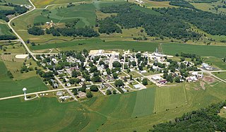
Maine is an incorporated village in Marathon County, Wisconsin, United States. It is part of the Wausau, Wisconsin Metropolitan Statistical Area. The population was 2,337 at the 2010 census. The unincorporated communities of Mount View and Taegesville are located partially in the town.

<span class="mw-page-title-main">Big Bend, Waukesha County, Wisconsin</span> Village in Wisconsin, United States

Big Bend is a village in Waukesha County, Wisconsin, United States. The population was 1,483 at the 2020 census.

<span class="mw-page-title-main">Vernon, Wisconsin</span> Village in Wisconsin, United States

Vernon is a village in Waukesha County, Wisconsin, United States. The population was 7,474 at the 2020 census.

<span class="mw-page-title-main">Earlville, New York</span> Village in New York, United States

Earlville is a village in New York state bisected by two counties: Madison County and Chenango County, United States. The population was 774 as per the 2020 Decennial census, a decrease from the 872 reported in the 2010 census. The village is named after Jonas Earl, a canal commissioner.

Bridgeport is a hamlet located partly in the town of Sullivan in Madison County, New York, United States and partly in the town of Cicero in Onondaga County. The population was 1,490 at the 2010 census.

<span class="mw-page-title-main">Madison (village), New York</span> Village in New York, United States

Madison is a village in Madison County, New York, United States. The population was 305 at the 2010 census. The village and its town are named after President James Madison.

<span class="mw-page-title-main">Bridgewater (CDP), New York</span> Hamlet and CDP in New York, United States

Bridgewater is a hamlet in Oneida County, New York, United States. The population was 470 at the 2010 census.

<span class="mw-page-title-main">Gratiot, Wisconsin</span> Village in Wisconsin, United States

Gratiot is a village in Lafayette County, Wisconsin, United States. The population was 236 at the 2010 census. The village is surrounded by the Town of Gratiot.

References

  1. "ArcGIS REST Services Directory". United States Census Bureau. Retrieved September 20, 2022.
  2. "The Ward Boys of Madison County NYS". www.northofseveycorners.com. Retrieved July 16, 2023.
  3. https://www.biblio.com/book/hojack-remembering-rw-railroad-division-peter/d/1461931958
  4. "US Gazetteer files: 2010, 2000, and 1990". United States Census Bureau. February 12, 2011. Retrieved April 23, 2011.
  5. "Census of Population and Housing". Census.gov. Retrieved June 4, 2015.
  6. "U.S. Census website". United States Census Bureau . Retrieved January 31, 2008.