Morrisville, New York

Last updated

Morrisville, New York
MSC Sign.jpg
Sign for Morrisville State College in the village
USA New York location map.svg
Red pog.svg
Morrisville, New York
Location within the state of New York
Coordinates: 42°53′55″N75°38′52″W / 42.89861°N 75.64778°W / 42.89861; -75.64778
Country United States
State New York
County Madison
Area
[1]
  Total1.02 sq mi (2.65 km2)
  Land1.02 sq mi (2.65 km2)
  Water0.00 sq mi (0.00 km2)
Elevation
1,348 ft (411 m)
Population
 (2020)
  Total1,633
  Density1,594.73/sq mi (615.61/km2)
Time zone UTC-5 (Eastern (EST))
  Summer (DST) UTC-4 (EDT)
ZIP code
13408
Area code 315
FIPS code 36-48593
GNIS feature ID0957706
Website https://www.morrisvilleny.com/

Morrisville is a village in Madison County, New York, United States. The population was 2,199 at the 2010 census. The village is named after its founder, Thomas Morris.

Contents

The Village of Morrisville in the northwest part of the Town of Eaton on US Route 20. Its zip code is 13408. Morrisville State College is located in the village.

History

The community was named for Thomas Morris and was originally called "Morris Flats." It was made the county seat in 1817 when it was moved from Cazenovia. In 1907 the county seat was moved again this time to Wampsville.

In 1908, the New York State School of Agriculture was established and occupied the old county buildings that were left empty

The First National Bank of Morrisville, Morrisville Public Library, and Old Madison County Courthouse are listed on the National Register of Historic Places. [2]

Geography

Morrisville is located at 42°53′55″N75°38′52″W / 42.89861°N 75.64778°W / 42.89861; -75.64778 (42.898541, -75.647717). [3]

According to the United States Census Bureau, the village has a total area of 1.1 square miles (2.8 km2), all land.

Climate

Climate data for Morrisville 6 SW, New York, 1991–2020 normals, 1911-2020 extremes: 1681ft (512m)
MonthJanFebMarAprMayJunJulAugSepOctNovDecYear
Record high °F (°C)69
(21)
68
(20)
82
(28)
87
(31)
90
(32)
96
(36)
100
(38)
97
(36)
95
(35)
86
(30)
78
(26)
65
(18)
100
(38)
Mean maximum °F (°C)50.6
(10.3)
50.4
(10.2)
60.5
(15.8)
76.0
(24.4)
82.4
(28.0)
85.1
(29.5)
86.3
(30.2)
85.6
(29.8)
82.8
(28.2)
74.6
(23.7)
64.5
(18.1)
54.6
(12.6)
85.6
(29.8)
Mean daily maximum °F (°C)27.6
(−2.4)
30.2
(−1.0)
38.2
(3.4)
51.8
(11.0)
64.4
(18.0)
72.6
(22.6)
77.2
(25.1)
75.9
(24.4)
69.2
(20.7)
56.0
(13.3)
44.4
(6.9)
33.1
(0.6)
53.4
(11.9)
Daily mean °F (°C)19.4
(−7.0)
21.3
(−5.9)
28.9
(−1.7)
42.1
(5.6)
54.4
(12.4)
63.0
(17.2)
67.3
(19.6)
66.0
(18.9)
59.2
(15.1)
47.0
(8.3)
36.5
(2.5)
26.1
(−3.3)
44.3
(6.8)
Mean daily minimum °F (°C)11.3
(−11.5)
12.4
(−10.9)
19.7
(−6.8)
32.4
(0.2)
44.4
(6.9)
53.3
(11.8)
57.4
(14.1)
56.2
(13.4)
49.2
(9.6)
38.0
(3.3)
28.6
(−1.9)
19.0
(−7.2)
35.2
(1.8)
Mean minimum °F (°C)−8.3
(−22.4)
−6.9
(−21.6)
−1.0
(−18.3)
19.0
(−7.2)
30.3
(−0.9)
40.3
(4.6)
47.9
(8.8)
46.8
(8.2)
36.2
(2.3)
25.5
(−3.6)
14.2
(−9.9)
0.9
(−17.3)
−11.2
(−24.0)
Record low °F (°C)−35
(−37)
−34
(−37)
−21
(−29)
−1
(−18)
20
(−7)
29
(−2)
33
(1)
31
(−1)
22
(−6)
4
(−16)
−12
(−24)
−37
(−38)
−37
(−38)
Average precipitation inches (mm)3.51
(89)
3.22
(82)
3.55
(90)
3.89
(99)
4.06
(103)
4.62
(117)
4.36
(111)
4.26
(108)
4.26
(108)
4.51
(115)
4.05
(103)
3.85
(98)
48.14
(1,223)
Average snowfall inches (cm)33.7
(86)
26.5
(67)
21.0
(53)
5.1
(13)
0.3
(0.76)
0.0
(0.0)
0.0
(0.0)
0.0
(0.0)
0.0
(0.0)
1.0
(2.5)
10.6
(27)
28.2
(72)
126.4
(321.26)
Source 1: NOAA(1981-2010 Snowfall) [4] [5]
Source 2: XMACIS2 (records & monthly max/mins) [6]

Demographics

Historical population
CensusPop.Note
1870 570
1880 74130.0%
1890 726−2.0%
1900 624−14.0%
1910 500−19.9%
1920 497−0.6%
1930 58317.3%
1940 66614.2%
1950 1,25087.7%
1960 1,3044.3%
1970 2,29676.1%
1980 2,70717.9%
1990 2,7320.9%
2000 2,148−21.4%
2010 2,1992.4%
2020 1,633−25.7%
U.S. Decennial Census [7]

As of the census [8] of 2000, there were 2,148 people, 362 households, and 195 families residing in the village. The population density was 1,863.4 inhabitants per square mile (719.5/km2). There were 398 housing units at an average density of 345.3 per square mile (133.3/km2). The racial makeup of the village was 79.93% White, 14.20% African American, 0.74% Native American, 2.23% Asian, 0.93% from other races, and 1.96% from two or more races. Hispanic or Latino of any race were 4.24% of the population.

There were 362 households, out of which 27.1% had children under the age of 18 living with them, 41.7% were married couples living together, 10.8% had a female householder with no husband present, and 45.9% were non-families. 32.0% of all households were made up of individuals, and 10.5% had someone living alone who was 65 years of age or older. The average household size was 2.29 and the average family size was 2.92.

In the village, the population was spread out, with 9.0% under the age of 18, 60.8% from 18 to 24, 11.4% from 25 to 44, 8.3% from 45 to 64, and 10.6% who were 65 years of age or older. The median age was 20 years. For every 100 females, there were 108.1 males. For every 100 females age 18 and over, there were 107.3 males.

The median income for a household in the village was $34,375, and the median income for a family was $50,536. Males had a median income of $29,028 versus $24,643 for females. The per capita income for the village was $8,983. About 9.0% of families and 19.7% of the population were below the poverty line, including 27.2% of those under age 18 and 0.8% of those age 65 or over.

Education

The village is the location of SUNY Morrisville, which includes Morrisville fish hatchery, and the Morrisville Equestrian Center. Colgate University is eight miles to the southeast, Cazenovia College is 12 miles west, and Syracuse University is 30 miles northwest.

In the 1980s cartoon series, The Real Ghostbusters , Morrisville was the hometown of Ray Stantz.

Related Research Articles

<span class="mw-page-title-main">Madison County, New York</span> County in New York, United States

Madison County is a county located in the U.S. state of New York. As of the 2020 census, the population was 68,016. Its county seat is Wampsville. The county is named after James Madison, the fourth president of the United States, and was first formed in 1806. The county is part of the Central New York region of the state.

<span class="mw-page-title-main">Manlius Township, Michigan</span> Township in Michigan, United States

Manlius Township is a civil township of Allegan County in the U.S. state of Michigan. The population was 3,312 at the 2020 census.

<span class="mw-page-title-main">Morrisville, Missouri</span> City in Missouri, United States

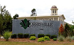
Morrisville is a city in southern Polk County, Missouri, United States. The population was 388 at the 2010 census. It is part of the Springfield, Missouri Metropolitan Statistical Area.

<span class="mw-page-title-main">Aurora, Erie County, New York</span> Town in New York, United States

Aurora is a town in Erie County, New York, United States. The population was 13,782 at the 2010 census. It is one of the "Southtowns" of Erie County and is also erroneously called "East Aurora", the name of its principal village. The town is centrally located in the county, southeast of Buffalo.

<span class="mw-page-title-main">Eaton, New York</span> Town in New York, United States

Eaton is a town in Madison County, New York, United States. The population was 4,284 at the 2020 census.

<span class="mw-page-title-main">Fenner, New York</span> Town in New York, United States

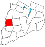
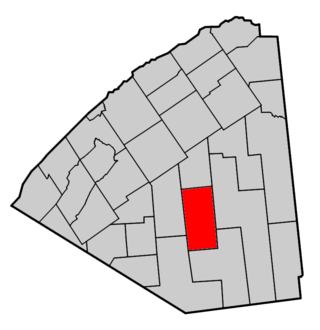
Fenner is a town in Madison County, New York, United States. The population was 1,726 at the 2010 census.

<span class="mw-page-title-main">Nelson, New York</span> Town in New York, United States

Nelson is a town in Madison County, New York, United States. It is an interior town, located in the southwestern part of the county. The population was 1,890 at the 2020 census. The town was named after Horatio Nelson, the English naval hero.

Smithfield is a town in Madison County, New York, United States. Administrative offices are in the hamlet of Peterboro. The town and hamlet both are named after Peter Smith, an original land owner. As of the 2010 Census, the population was 1,288.

<span class="mw-page-title-main">Pittsfield, New York</span> Town in New York, United States

Pittsfield is a town in Otsego County, New York, United States. The population was 1,366 at the 2010 census.

<span class="mw-page-title-main">Clare, New York</span> Town in New York, United States

Clare is a town in St. Lawrence County, New York, United States. The population was 105 at the 2010 census.

<span class="mw-page-title-main">Tatum, South Carolina</span> Town in South Carolina, United States

Tatum is a town in Marlboro County, South Carolina, United States. The population was 75 at the 2010 census.

<span class="mw-page-title-main">Morristown, Vermont</span> Town in Vermont, United States

Morristown is a town in Lamoille County, Vermont, United States. As of the 2020 census, the population was 5,434. Morristown is the largest town by population in Lamoille County, and its central village of Morrisville serves as the county's main commercial center.

<span class="mw-page-title-main">Clarno, Wisconsin</span> Township in Wisconsin, United States

Clarno is a town in Green County, Wisconsin, United States. The population was 1,079 at the 2000 census. The unincorporated communities of Clarno and Schneyville are located in the town.

<span class="mw-page-title-main">Earlville, New York</span> Village in New York, United States

Earlville is a village in New York state bisected by two counties: Madison County and Chenango County, United States. The population was 774 as per the 2020 Decennial census, a decrease from the 872 reported in the 2010 census. The village is named after Jonas Earl, a canal commissioner.

Afton is a village in Chenango County, New York, United States. The population was 822 at the 2010 census. The village is named after the poem "Sweet Afton" by Scottish poet Robert Burns, referring to the River Afton in Ayrshire, Scotland.

<span class="mw-page-title-main">Cazenovia (village), New York</span> Village in New York, United States

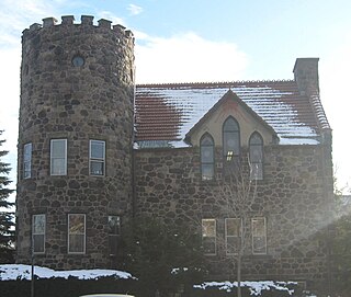
Cazenovia is a village located in the Town of Cazenovia in Madison County, New York, United States. As of the 2010 census, the village had a population of 2,835. The village lies on the southeastern shore of Cazenovia Lake, which is approximately 4 miles (6.4 km) long and .5 mile across. Cazenovia is within a half hour of Syracuse, New York. The village is located on US Route 20 and New York State Route 13, and was home to Cazenovia College.

<span class="mw-page-title-main">Cazenovia, New York</span> Town in New York, United States

Cazenovia is an incorporated town in Madison County, New York. The population was 6,740 at the time of the 2020 census. The town is named after Theophile Cazenove, the Agent General of the Holland Land Company.

<span class="mw-page-title-main">DeRuyter (village), New York</span> Village in New York, United States

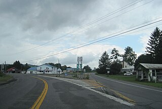
DeRuyter is a village located in the Town of DeRuyter in Madison County, New York, United States. The population was 558 at the 2010 census. The village and town are named after Michiel Adriaenszoon de Ruyter, a famous admiral in the Dutch navy.

<span class="mw-page-title-main">Fabius (village), New York</span> Village in New York, United States

Fabius is a village in Onondaga County, New York, United States. As of the 2020 census, the population was 309. It is part of the Syracuse Metropolitan Statistical Area. The village is near the center of the town of Fabius and is south of Syracuse.

Morris is a village in Otsego County, New York, United States. The population was 583 at the 2010 census.

References

  1. "ArcGIS REST Services Directory". United States Census Bureau. Retrieved September 20, 2022.
  2. "National Register Information System". National Register of Historic Places . National Park Service. March 13, 2009.
  3. "US Gazetteer files: 2010, 2000, and 1990". United States Census Bureau. February 12, 2011. Retrieved April 23, 2011.
  4. "Morrisville 6 SW, New York 1991-2020 Monthly Normals" . Retrieved December 13, 2023.
  5. "Morrisville 6 SW, New York 1981-2010 Monthly Normals" . Retrieved December 13, 2023.
  6. "xmACIS". National Oceanic and Atmospheric Administration. Retrieved December 13, 2023.
  7. "Census of Population and Housing". Census.gov. Retrieved June 4, 2015.
  8. "U.S. Census website". United States Census Bureau . Retrieved January 31, 2008.