Manchester (village), New York

Last updated
Manchester, New York
USA New York location map.svg
Red pog.svg
Manchester, New York
Location within the state of New York
Coordinates: 42°58′10″N77°13′34″W / 42.96944°N 77.22611°W / 42.96944; -77.22611 Coordinates: 42°58′10″N77°13′34″W / 42.96944°N 77.22611°W / 42.96944; -77.22611
Country United States
State New York
County Ontario
Area
[1]
  Total1.14 sq mi (2.96 km2)
  Land1.14 sq mi (2.96 km2)
  Water0.00 sq mi (0.00 km2)
Elevation
591 ft (180 m)
Population
 (2020)
  Total1,640
  Density1,437.34/sq mi (554.91/km2)
Time zone UTC-5 (Eastern (EST))
  Summer (DST) UTC-4 (EDT)
ZIP code
14504
Area code 585
FIPS code 36-44853
GNIS feature ID0956335
Website www.villageofmanchester.org

Manchester is a village located within the Town of Manchester in Ontario County, New York, United States. The population was 1,709 at the 2010 census. The village was named after Manchester in England.

Contents

The Village of Manchester is located in the southwest part of the town, north of Canandaigua.

(The area and population reported and analyzed in this article are also included in the aggregate values for the town as a whole. See: Manchester (town), New York.)

History

The future village was the first settlement in the Town, in 1793. The community was originally called "Coonsville," after one of its early settlers, Valentine Coon, but when manufacturing became important, the name was changed to "Manchester." The village was incorporated in 1892.

Geography

According to the United States Census Bureau, the village has a total area of 1.2 square miles (3.0 km2), all land.

New York State Route 21 passes through the village, which is located immediately south of the New York State Thruway (exit 43) and New York State Route 96.

Demographics

Historical population
CensusPop.
1880 329
1900 711
1910 88123.9%
1920 1,41861.0%
1930 1,4290.8%
1940 1,330−6.9%
1950 1,262−5.1%
1960 1,3446.5%
1970 1,305−2.9%
1980 1,69830.1%
1990 1,598−5.9%
2000 1,475−7.7%
2010 1,70915.9%
2020 1,640−4.0%
U.S. Decennial Census [2]

As of the census of 2000, there were 1,475 people, 648 households, and 395 families residing in the village. The population density was 1,259.8 people per square mile (486.8/km2). There were 688 housing units at an average density of 227.0 persons/km2 (587.6 persons/sq mi). The racial makeup of the village was 97.56% White, 0.41% African American, 0.34% Native American, 0.20% Asian, 0.00% Pacific Islander, 0.20% from other races, and 1.29% from two or more races. 1.15% of the population were Hispanic or Latino of any race.

There were 648 households, out of which 23.9% had children under the age of 18 living with them, 47.7% were married couples living together, 9.1% have a woman whose husband does not live with her, and 38.9% were non-families. 31.3% of all households were made up of individuals, and 18.7% had someone living alone who was 65 years of age or older. The average household size was 2.28 and the average family size was 2.84.

In the village, the population was spread out, with 21.9% under the age of 18, 6.1% from 18 to 24, 25.2% from 25 to 44, 23.1% from 45 to 64, and 23.7% who were 65 years of age or older. The median age was 43 years. For every 100 females, there were 97.7 males. For every 100 females age 18 and over, there were 89.5 males.

The median income for a household in the village was $36,146, and the median income for a family was $44,625. Males had a median income of $31,792 versus $25,156 for females. The per capita income for the village was $17,956. 7.2% of the population and 3.0% of families were below the poverty line. Out of the total people living in poverty, 11.9% are under the age of 18 and 3.5% are 65 or older.

Related Research Articles

<span class="mw-page-title-main">Sylvania, Alabama</span> Town in Alabama, United States

Sylvania is a town in DeKalb County, Alabama, United States. It incorporated in October 1967. At the 2010 census the population was 1,837, up from 1,186 in 2000. Sylvania is located atop Sand Mountain.

<span class="mw-page-title-main">Indian Springs Village, Alabama</span> Rural Area in Alabama, United States

Indian Springs Village is a rural town in Shelby County, Alabama, United States, in the Birmingham metropolitan area. It incorporated effective November 14, 1990. At the 2010 census the population was 2,363, up from 2,225 in 2000.

<span class="mw-page-title-main">Ragland, Alabama</span> Town in Alabama, United States

Ragland is a town in St. Clair County, Alabama, United States southeast of Ashville. It incorporated in 1899. At the 2010 census the population was 1,639, down from 1,918 in 2000. It is part of the Birmingham-Hoover-Cullman Combined Statistical Area.

<span class="mw-page-title-main">Plainfield Village, Connecticut</span> Village in Connecticut, United States

Plainfield Village is a village and census-designated place (CDP) in the town of Plainfield, Connecticut in the United States. The population was 2,557 at the 2010 census. It is located in the southwest part of town, in the area west of I-395 and south of Route 14. The village is also the core of the Plainfield, CT urban cluster.

<span class="mw-page-title-main">Manchester, Maine</span> Town in Maine, United States

Manchester is a town in Kennebec County, Maine, United States, located at 44.33°N 69.87°W. The population was 2,456 at the 2020 census. The southern part of the town bordering Cobbosseecontee Lake is a popular recreation spot in central Maine, and part of the Winthrop Lakes Region. Manchester is included in the Augusta, Maine micropolitan New England City and Town Area.

<span class="mw-page-title-main">Goodrich, Michigan</span> Village in Michigan, United States

Goodrich is a village in Genesee County in the U.S. state of Michigan. The population was 1,860 at the 2010 census. The village is a suburb of Flint located within Atlas Township.

<span class="mw-page-title-main">New Scotland, New York</span> Town in New York, United States

New Scotland is a town in Albany County, New York, United States. The population was 8,648 at the 2010 census.

<span class="mw-page-title-main">Morrisonville, New York</span> Census-designated place in New York, United States

Morrisonville is a hamlet and census-designated place in Clinton County, New York, United States. The population was 1,545 at the 2010 census.

<span class="mw-page-title-main">Kirkland, New York</span> Town in Oneida County, New York, United States

Kirkland is a town in Oneida County, New York, United States. The population was 10,315 at the 2010 census. The town is named after Samuel Kirkland, a missionary among the Oneidas.

<span class="mw-page-title-main">Attica, Ohio</span> Village in Ohio, United States

Attica is a village in Seneca County, Ohio, United States. The population was 899 at the 2010 census.

<span class="mw-page-title-main">Richfield, Ohio</span> Village in Ohio, United States

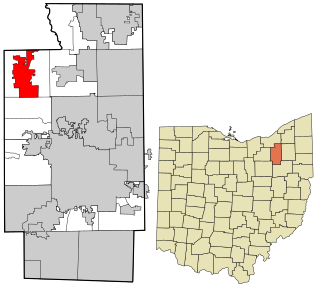
Richfield is a village in Summit County, Ohio, United States. The population was 3,648 at the 2010 census. The village and the adjacent Richfield Township are approximately equidistant between the downtown areas of Akron and Cleveland. It is part of the Akron metropolitan area. Richfield is the sister city of Wolfach, Germany.

<span class="mw-page-title-main">Apple Creek, Ohio</span> Village in Ohio, United States

Apple Creek is a village in East Union Township, Wayne County, Ohio, United States. The population was 1,173 at the 2010 census.

<span class="mw-page-title-main">Manchester, Pennsylvania</span> Borough in Pennsylvania, United States

Manchester is a borough in York County, Pennsylvania, United States. The population was 2,798 at the 2020 census.

<span class="mw-page-title-main">White Hall, West Virginia</span> Town in West Virginia, United States

White Hall is a town in Marion County, West Virginia, United States. The population was 706 at the 2020 census. White Hall became incorporated in 1989. White Hall is right beside Fairmont and has many different stores and restaurants.

<span class="mw-page-title-main">Lebanon, Waupaca County, Wisconsin</span> Town in Wisconsin, United States

Lebanon is a town in Waupaca County, Wisconsin, United States. The population was 1,648 at the 2000 census. The unincorporated community of Carmel is located in the town. The ghost town of Nowell was also located in the town.

<span class="mw-page-title-main">Sherburne (village), New York</span> Village in New York, United States

Sherburne is a village in Chenango County, New York, United States. The population was 1,367 at the 2010 census. It is in the town of Sherburne, north of Norwich.

<span class="mw-page-title-main">Hamburg (village), New York</span> Village in New York, United States

Hamburg is a village in Erie County, New York, United States. The population was 9,409 at the 2010 census. The village is named after Hamburg, a city in Germany. It is part of the Buffalo–Niagara Falls Metropolitan Statistical Area.

<span class="mw-page-title-main">Oakfield (village), New York</span> Village in New York, United States

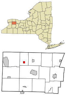
Oakfield is a village in Genesee County, New York, United States. As of the 2010 census, the village population was 1,813. The village lies within the town of Oakfield in northern Genesee County. The village is at the intersection of Route 63 and Route 262. It is northwest of Batavia.

<span class="mw-page-title-main">Oswego (town), New York</span> Town in New York, United States

Oswego is a town in Oswego County, in the U.S. state of New York. The population was 7,984 at the 2010 census.

Castile is a village in Wyoming County, New York, United States. The population was 1,015 at the 2010 census.

References

  1. "ArcGIS REST Services Directory". United States Census Bureau. Retrieved September 20, 2022.
  2. "Census of Population and Housing". Census.gov. Retrieved June 4, 2015.