Related Research Articles
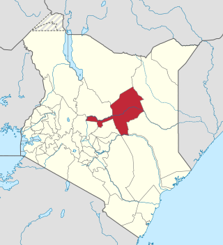
Laikipia County is one of the 47 Counties of Kenya, located on the Equator in the former Rift Valley Province of the Country. Laikipia is a cosmopolitan County and is Listed as County number 31. The county has two major urban centres: Nanyuki to the southeast, and Nyahururu to the southwest. Its County government headquarters town is Nanyuki. The County lies between latitudes 0° 18" South and 0° 51" North and between longitude 36° 11" and 37° 24' East. It borders Samburu County to the North, Isiolo County to the North East, Meru County to the East, Nyeri County to the South East, Nyandarua County to the South, Nakuru County to the South West and Baringo County to the West.

Kericho County is one of the 47 counties in Kenya. The county seats between longitude 35°02' and 35°40' East and between the equator and latitude 0°23' South with an altitude of about 2002m above the sea level. It borders Uasin Gishu County to the North West, Baringo County to the North, Nandi County to the North-West, Nakuru County to the East and Bomet County to the South. It has a population of 901,777 and an area of 2,111 km². Its capital and largest town is Kericho.

Lamu County is a county of Kenya located along the North Coast of the country and is one of the six Coastal Counties in Kenya. Its capital is the town of Lamu. It borders Tana River County to the southwest, Garissa County to the north, Somalia to the northeast, and the Indian Ocean to the South.

Kiambu County is a county in the former Central Province of Kenya. Its capital is Kiambu and its largest town is Thika. Kiambu County is the second most populous after Nairobi County. Kiambu County borders Nairobi and Kajiado Counties to the South, Machakos to the East, Murang'a to the North and North East, Nyandarua to the North West, and Nakuru to the West and has a population of 2,417,735.

Marsabit County is a county in Kenya. Covering a surface area of 66,923.1 square kilometres. Marsabit is the second largest county in Kenya. Its capital is Marsabit and its largest town Moyale. According to the 2019 census, the county has a population of 459,785. It is bordered to the North by Ethiopia, to the West by Turkana County to the South by Samburu County and Isiolo County, and to the East by Wajir County.
Isiolo County is a county in the former Eastern Province of Kenya. Its population is 268,002 and its capital and largest city is Isiolo. Isiolo County is to be the first county to be developed as part of the Kenya Vision 2030 program. Other upcoming urban centres are: Garbatulla, Modogashe, Kinna, Merti and Oldonyiro.

Makueni County is a county in the former Eastern Province of Kenya. Its capital and largest town is Wote. The county has a population of 987,653. The county lies between Latitude 1° 35' and 2° 59' South and Longitude 37° 10' and 38° 30' East. It borders Machakos to the North, Kitui to the East, Taita Taveta to the South and Kajiado to the West and covers an area of 8,008.9 km2.
Homa Bay County is a county in the former Nyanza Province of Kenya. Its capital and largest town is Homa Bay. The county has a population of 1,131,950 and an area of 3,154.7 km2. Lake Victoria is a major source of livelihood for Homa Bay County. It has 40 wards, each represented by an MCA to the assembly in Homa Bay town as its headquarters.

Garissa County is an administrative county in Kenya. Its capital and largest urban area is Garissa. The county had a population of 841,353 at the 2019 Census, and a land area of about 44,753 km2 (17,279 sq mi).

Mandera County is the northeasternmost county in Kenya. Its capital and largest town is Mandera. The county is bordered by Ethiopia to the north, Somalia to the east and Wajir County to the southwest. According to the 2019 census, the county has a population of 1,200,890 and an area of 25,939.8 square kilometres (10,015.4 sq mi). The main economic activity in the county is pastoralism, while others include cross-border trade with Ethiopia, artisanal mining, beekeeping, and agriculture along the Dawa River.
Kamukunji Constituency is an electoral constituency in Kenya. It is one of seventeen constituencies of Nairobi County. It consists of central to eastern areas of Nairobi. Kamukunji constituency had common boundaries with Pumwani Division of Nairobi. The entire constituency is located within Nairobi City County area. The constituency has an area of 8.80 km2 (3.4 sq mi). The constituency forms part of what was known as Nairobi Central Constituency at the 1963 elections. Kamukunji Constituency was conceived prior to the 1969 elections. The current constituency boundaries were revised prior to the 2013 elections. It borders Starehe Constituency to the west, Makadara to the south, Embakasi West Constituency to the east, and Mathare Constituency to the north.
Lang'ata Constituency is an electoral constituency in Nairobi City County. It is one of the seventeen constituencies in the county. It consists of southern and southwestern areas of Nairobi. Langata constituency had common boundaries with a now defunct Kibera Division of Nairobi. It is the largest constituency in Nairobi with an area of 196.80 km2 (76.0 sq mi). It was known as Nairobi South Constituency at the 1963 elections but since 1969 elections it has been known as Lang'ata Constituency.
Cherangany Constituency, comprises the larger Trans Nzoia East District; otherwise known as Cherangani Sub-County, with an approximate area of 556.9 square km. It is an electoral constituency in Kenya, which was established/created for the 1988 general election.
Makueni Constituency is an electoral constituency in Kenya. It is one of six constituencies in Makueni County. The constituency was established for the 1966 elections.Its current MP is Daniel Kitonga Maanzo of Wiper party who is also vying for Makueni Senate.

Kisii County is a county in the former Nyanza Province in southwestern Kenya. Its capital and largest town is Kisii. The county has a population of 1,266,860 people. It borders Nyamira County to the North East, Narok County to the South, and Homabay and Migori Counties to the West. The county covers an area of 1,317.5 km.
Mathioya Constituency is an electoral constituency in Kenya. It is one of seven constituencies of Muranga County. The constituency has three wards comprising Kiru, Kamacharia and Gitugi wards all electing Members of the County Assembly to the Muranga County Assembly.

Nairobi City County is one of the 47 counties of Kenya. With a population of 4,397,073 in the 2019 census, it is the third smallest yet the most populous of the counties, also serving as the capital of Kenya. In 2013, the county entity was effected, replacing Nairobi City Council, the long-standing unit of administration since pre-independence. The city county consists of eleven gazetted sub-counties and eighty five electoral wards. On the national level, Nairobi also sends seventeen Members of Parliament across the constituencies and one County Woman Representative to the National Assembly; one senator to the Senate. The county government, which is allocated devolved functions as per the constitution, is headed by the county governor, who appoints his cabinet. The county's legislature is headed by the County Speaker, who presides over the County Assembly: single-member elected Members of the County Assembly (MCAs) represent their respective electoral wards. Additional MCAs are also nominated by political parties as a form of affirmative action.
Sigowet-Soin is an electoral constituency in Kericho County, Kenya. Its one of six Constituencies of Kericho County. It was created for 2013 General Elections after it being curved out of Belgut Constituency. First member of Parliament was Justice Kemei and currently the sitting MP for the constituency is Kipsengeret Koros.
Mandera South is a constituency in Mandera County, Kenya. It is one of six constituencies in Mandera County. It's wards are.
Takaba is a town in Mandera County, in northeastern Kenya. According to the 2009 census, the town was the fourth most populous in the county with a population of 21,474. The town has a functional airstrip. The headquarters of Mandera West sub-county are located in Takaba.
References
- ↑ Center for Multiparty Democracy: Politics and Parliamentarians in Kenya 1944–2007 Archived 2008-10-28 at the Wayback Machine
- ↑ Electoral Commission of Kenya: Registered voters per polling station by electoral area/ward and constituency Archived 2007-09-29 at the Wayback Machine