Manston, Kent

Last updated

Manston
ManstonKent.JPG
War memorial and St Catherine's Church
Kent UK location map.svg
Red pog.svg
Manston
Location within Kent
Population1,138 {2011} [1]
OS grid reference TR348662
Civil parish
  • Manston
District
Shire county
Region
Country England
Sovereign state United Kingdom
Post town Ramsgate
Postcode district CT12
Dialling code 01843
Police Kent
Fire Kent
Ambulance South East Coast
UK Parliament
List of places
UK
England
Kent

51°20′46″N1°22′12″E / 51.346°N 1.370°E / 51.346; 1.370

Contents

Manston, Kent

Manston is a village and civil parish [2] in the Thanet district of Kent, England. The village is situated one mile northwest of Ramsgate. The parish includes four hamlets and the former Manston Airport.

Etymology

The village was originally Mannestone which means 'farm on top of a hill' (a possible alternative variation is a farm belonging to a man called Mann) and was recorded in 1254 as Manneston, [3] but obtained its modern spelling in 1381 around the time of the Peasants' Revolt [ citation needed ].

History

The discovery of an Anglo-Saxon sword at what is known as the Ozengell burial ground [4] and also 200 graves including a Roman stone and lead-lined coffin, never preserved[ clarification needed ], show that the site has been occupied for many centuries.

In June 1381 the Peasants' Revolt reached Manston.

"A proclamation in the name of Jack Straw and Wat Tyler ordered that labour services should not be performed nor distraints made, and called on the people to destroy the Manston house of William dea Medmenham [a local coroner who evidently acted as representative for St Augustine's and Catherine's], and if possible behead him. The same day a crowd some 200 strong attacked the house, burnt "the books and muniments" and "took away and burnt the rolls" to the value of 20 marks." [5]

Two road names in the parish give clues to its past. Manston Court Road refers to Manston Court, [6] the seat of the Manston family who held high office, including Richard de Manston at the time of King John (circa 1200) and William Manston, Sheriff of Kent in 1436; and Spratling Street gets its name from the Sprakling family who lived in Ellington in Ramsgate from 1558 to 1659, at a time when Manston was still a part of St Lawrence Extra.

Smuggling was rife in the Isle in the 17th and 18th centuries. Manston Cave, on the road towards Sandwich, was one of the smugglers' hideouts. Little of it now remains. [7]

In 1901, the Isle of Thanet Poor Law Union opened a children's home at Manston. The homes comprised four pairs of houses and could accommodate a total of 120 children. In the 1901 census there were 46 inmates and the Superintendent was Edmund L Martins. One of the orphans, Frank Sidney Smith, an artist, painted a picture of Manston from memory in later life. This is now hanging in St Catherine's Church. The children's homes have now been converted to residential use. The orphanage's school is now the village hall. [8]

During both World Wars the Manston area became important as an aircraft base, particularly in the Second World War as an airfield for emergency landings of damaged Allied bombers returning from the continent. The RAF Manston Museum tells the story of the air station. [9]

The former RAF Manston became home to Kent International Airport, which closed in May 2014. The site opened as a processing centre for migrants arriving in the UK by sea in February 2022, with the aim of having between 1,000 and 1,600 people passing through it on a daily basis, with all checks completed within 24 hours. An inspection in July found that immigrants were being detained there much longer. By October of that year, the local MP was reporting that there were over 4,000 people housed at the site, although a visit from the independent chief inspector of borders and immigration placed the number at 2,800 on his visit that month. Diseases like diphtheria were spreading through the population and in November the Home Office took the decision to clear the site and place all those who were staying at Manston in alternative accommodation. [10]

Governance

Manston Parish Council consists of seven members and holds its meetings in the RAF Museum

Geography

Manston Parish lies in the middle of the Isle of Thanet and includes the hamlets of Haine, Lydden, Woodchurch and Shottendane. A large part of it is agricultural land.

The village

St Catherine's Church [11] was built in 1872 with monies raised by locals as a Chapel of ease for those of the St Lawrence Parish who were unable to attend the church in St Lawrence. The land was donated by the Vicar of St Lawrence, Rev. G. W. Sicklemore. There is a war memorial on the village green to those who served and died in the two world wars of the twentieth century.

The village pub is The Jolly Farmer, located in what was in 1672 part of a pair of farm dwellings, and originally registered as a public house in November 1738 by Lazarus Haywood under the name "Jolly Farmers". It was leased to its first tenant Keeper, Samuel Packer (a boot and shoe maker from Ramsgate) in March 1739. During the Second World War the Jolly Farmer was a favourite of pilots stationed at RAF Manston. It was rumoured that many of the pilots signed their names on the ceiling of 'the snug', but this has been painted over and so the rumour is unverifiable[ citation needed ]. The licensee from 1957 to 1980 was the footballer Bert Turner.

There is an active village hall with its own committee, used during elections as a polling station; and two caravan parks: Preston Parks (statics) and Manston Court.

The erstwhile post office and village store is now closed: the post box bearing the mark of GR is all that remains. There is flourishing Garden Club. [12]

Transport

Kent International Airport (formerly RAF Manston) is located near the village. Plans were announced in October 2013 for a new railway station to serve the village and airport. [13] The airport closed on 15 May 2014.

Related Research Articles

<span class="mw-page-title-main">Minster-in-Thanet</span> Human settlement in England

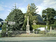
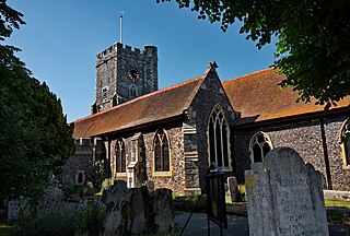
Minster, also known as Minster-in-Thanet, is a village and civil parish in the Thanet District of Kent, England. It is the site of Minster in Thanet Priory. The village is west of Ramsgate and to the north east of Canterbury; it lies just south west of Kent International Airport and just north of the River Stour. Minster is also the "ancient capital of Thanet". At the 2011 Census the hamlet of Ebbsfleet was included.

<span class="mw-page-title-main">Isle of Thanet</span> Peninsula in Kent, England

The Isle of Thanet is a peninsula forming the easternmost part of Kent, England. While in the past it was separated from the mainland by the 600-metre-wide (2,000 ft) Wantsum Channel, it is no longer an island.

<span class="mw-page-title-main">Ramsgate</span> Seaside town in Kent, England

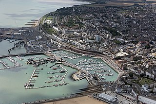
Ramsgate is a seaside town and civil parish in the district of Thanet in east Kent, England. It was one of the great English seaside towns of the 19th century. In 2021 it had a population of 42,027. Ramsgate's main attraction is its coastline, and its main industries are tourism and fishing. The town has one of the largest marinas on the English south coast, and the Port of Ramsgate provided cross-channel ferries for many years.

<span class="mw-page-title-main">Broadstairs</span> Coastal town in Kent, England

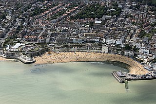
Broadstairs is a coastal town on the Isle of Thanet in the Thanet district of east Kent, England, about 80 miles (130 km) east of London. It is part of the civil parish of Broadstairs and St Peter's, which includes St Peter's, and had a population in 2011 of about 25,000. Situated between Margate and Ramsgate, Broadstairs is one of Thanet's seaside resorts, known as the "jewel in Thanet's crown". The town's coat of arms' Latin motto is Stella Maris. The name derives from a former flight of steps in the chalk cliff, which led from the sands up to the 11th-century shrine of St Mary on the cliff's summit.

<span class="mw-page-title-main">Manston Airport</span> Closed airport in Kent, England, United Kingdom

Manston Airport is a British airport. Originally operated as RAF Manston, from 1918, it has also operated as a commercial airport and was known as Kent International Airport and, briefly, London Manston Airport. It has been closed since 2014. Located in the parish of Minster-in-Thanet and partly adjacent to the village of Manston in the Thanet district of Kent, England, 11 NM north-east of Canterbury.

<span class="mw-page-title-main">St Nicholas-at-Wade</span> Human settlement in England

St Nicholas-at-Wade is both a village and a civil parish in the Thanet District of Kent, England. The parish had a recorded population of 782 at the 2001 Census, increasing to 852 at the 2011 census. The village of Sarre is part of the civil parish.

Royal Air Force Manston or more simply RAF Manston is a former Royal Air Force station located in the north-east of Kent, at grid reference TR334663 on the Isle of Thanet from 1916 until 1996. The site was split between a commercial airport Kent International Airport (KIA), since closed, and a continuing military use by the Defence Fire Training and Development Centre (DFTDC), following on from a long-standing training facility for RAF firefighters at the RAF Manston base. In March 2017, RAF Manston became the HQ for the 3rd Battalion, Princess of Wales Royal Regiment (PWRR).

<span class="mw-page-title-main">Sturry</span> Human settlement in England

Sturry is a village on the Great Stour river situated 3 miles (4.8 km) northeast of Canterbury in Kent. Its large civil parish incorporates several hamlets and, until April 2019, the former mining village of Hersden.

<span class="mw-page-title-main">Thanet District</span> Non-metropolitan district in England

Thanet is a local government district in Kent, England. The council is based in Margate and the district also contains the towns of Broadstairs, Ramsgate and Westgate-on-Sea, along with several villages. It takes its name from the Isle of Thanet, a former island which gradually became connected to the mainland between the 12th and 16th centuries.

<span class="mw-page-title-main">Westgate-on-Sea</span> Seaside town in Kent, England

Westgate-on-Sea is a seaside town and civil parish on the north-east coast of Kent, England. It is within the Thanet local government district and borders the larger seaside resort of Margate. Its two sandy beaches have remained a popular tourist attraction since the town's development in the 1860s from a small farming community. The town had a population of 6,996 at the 2011 Census.

<span class="mw-page-title-main">Birchington-on-Sea</span> Village in Kent, England

Birchington-on-Sea is a village in the Thanet district in Kent, England, with a population of 9,961.

<span class="mw-page-title-main">Hersden</span> Human settlement in England

Hersden is a village east of Canterbury in Kent, South East England. It was established as a planned coalmining village in the 1920s and is on the A28 road between Canterbury and the Isle of Thanet. Work in the Kent Coalfield was the main source of employment in the village until the closure of the Kent colliery in the 1980s.

<span class="mw-page-title-main">History of Ramsgate</span>

Ramsgate as a name has its earliest reference as 'Ramisgate' or 'Remmesgate' in 1275, from Anglo-Saxon 'Hraefn's geat, or 'Raven's cliff gap', later to be rendered 'Ramesgate' from 1357.

<span class="mw-page-title-main">Historic buildings in Ramsgate</span>

Ramsgate is a seaside town in the district of Thanet in east Kent, England, with a population of 39,639 in the '2001 UK Census. It was one of the great English seaside towns of the 19th century. Ramsgate's main attraction is its coastline, and its main industries are tourism and fishing. The town has one of the largest marinas on the English south coast, and the Port of Ramsgate provided cross-channel ferries for many years.

<span class="mw-page-title-main">St Peter's, Kent</span> Human settlement in England

St Peter's is an area of Broadstairs, a town on the Isle of Thanet in Kent. Historically a village, it was outgrown by the long-dominant settlement of the two, Broadstairs, after 1841. Originally the borough or manor of the church of St. Peter-in-Thanet, it was said to be the largest parish east of London, at least until Broadstairs became a separate parish on 27 September 1850. The two settlements were formally merged administratively in 1895.

Transportation needs within the county of Kent in South East England has been served by both historical and current transport systems.

<span class="mw-page-title-main">Cliffsend</span> Human settlement in England

Cliffsend is a village and civil parish situated almost 2 miles (3 km) west of Ramsgate, Kent, United Kingdom, in the Thanet local government district.

Ramsgate Airport was a civil airfield at Ramsgate, Kent, United Kingdom which opened in July 1935. It was briefly taken over by the Royal Air Force in the Second World War, becoming RAF Ramsgate. The airfield was then closed and obstructed to prevent its use. It reopened in 1953 and served until final closure in 1968. The site has now been redeveloped as an industrial estate.

<span class="mw-page-title-main">Thanet Parkway railway station</span> Railway station in Cliffsend, England

Thanet Parkway railway station is a railway station in Cliffsend, Kent, that serves Discovery Park Enterprise Zone and new housing developments. It opened on 31 July 2023.

References

  1. "Civil Parish population 2011" . Retrieved 2 October 2015.
  2. Manston Parish Council Manston Parish Council]
  3. Mills, A. D. (1998). Dictionary of English Place-Names. Oxford University Press. p. 233. ISBN   0-19-280074-4.
  4. Notes on Ozengell excavations
  5. RKI Quested on Sackett Family archive
  6. "A history of Manston Court". Archived from the original on 4 September 2011. Retrieved 1 October 2008.
  7. Manston Cave (Ingoldsby Legends)
  8. P Higginbottom - Workhouses in Thanet Archived 24 September 2006 at the Wayback Machine
  9. RAF Manston museum
  10. "Manston migrant centre: What were the problems?". BBC News. 31 October 2022. Retrieved 11 December 2023.
  11. St Catherine's church Archived 4 December 2004 at the Wayback Machine
  12. Manston Garden Club Archived 13 March 2007 at the Wayback Machine
  13. "Plans for Manston Airport railway station drawn up". BBC News Online. 2 October 2012.