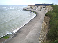
The area is predominantly housing, but also has recreational land for the general public. Palm Bay is one of many bays round the coast of Thanet. Palm Bay lies between Walpole and Botany Bays and is popular as a centre for Jet Skiing, the eastern end of Palm Bay is also known as Forness Bay and is the home to a local water skiing club.
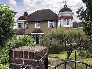
The original Palm Bay estate was built in the 1930s as a number of large, wide avenues with detached and semi-detached houses with driveways, garages and gardens. This land was sold by Mr Sidney Simon Van Den Bergh to the Palm Bay Estate Co on 23 June 1924. Such avenues include Gloucester Avenue and Leicester Avenue.
The estate covers the eastern part of Cliftonville and was fields when the first was built. It extends east beyond Northumberland Avenue and has been developed in phases. An earlier phase covered the northern ends of Leicester and Gloucester Avenues and the whole of Clarence and Magnolia Avenues; the later phase extending eastwards of Princess Margaret Avenue is a Wimpy style housing estate with small houses largely identical in appearance and of less substantial build quality than the original 1930s estate.
This is also the location of the Kent Airshow, first taking place in 2005 and again in 2006. For 2007, 2008 and 2009 the airshow was called the Big Event and featured a funfair as well as the air displays.
The Isle of Thanet is a peninsula forming the easternmost part of Kent, England. While in the past it was separated from the mainland by the 600-metre-wide (2,000 ft) Wantsum Channel, it is no longer an island.
Broadstairs is a coastal town on the Isle of Thanet in the Thanet district of east Kent, England, about 80 miles (130 km) east of London. It is part of the civil parish of Broadstairs and St Peter's, which includes St Peter's, and had a population in 2011 of about 25,000. Situated between Margate and Ramsgate, Broadstairs is one of Thanet's seaside resorts, known as the "jewel in Thanet's crown". The town's coat of arms' Latin motto is Stella Maris. The name derives from a former flight of steps in the chalk cliff, which led from the sands up to the 11th-century shrine of St Mary on the cliff's summit.
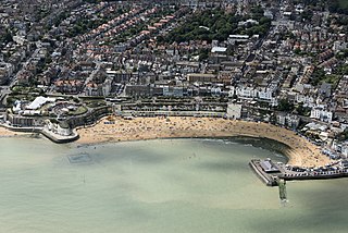
Margate is a seaside town in the Thanet District of Kent, England. It is located on the north coast of Kent and covers an area of 2 miles long, 16 miles north-east of Canterbury and includes Cliftonville, Garlinge, Palm Bay and Westbrook. In 2011 it had a population of 61,223.
Kelvindale is a district in the West End of the city of Glasgow, Scotland. Kelvindale shares the G12 postcode with the neighbouring residential districts of Kelvinside, Hillhead, Hyndland, Dowanhill, as well as Gartnavel General Hospital, Glasgow Clyde College (Anniesland) and the University of Glasgow, and is also close to the Anniesland and Wyndford areas of the city. The area is characterised by traditional interwar housing, formed of tenements and semi-detached houses.
Thanet is a local government district in Kent, England. The council is based in Margate and the district also contains the towns of Broadstairs, Ramsgate and Westgate-on-Sea, along with several villages. It takes its name from the Isle of Thanet, a former island which gradually became connected to the mainland between the 12th and 16th centuries.
Westgate-on-Sea is a seaside town and civil parish on the north-east coast of Kent, England. It is within the Thanet local government district and borders the larger seaside resort of Margate. Its two sandy beaches have remained a popular tourist attraction since the town's development in the 1860s from a small farming community. The town had a population of 7,517 at the 2021 Census.
Kingsthorpe is a suburb and civil parish of Northampton, England. It is situated to the north of Northampton town centre and is served by the A508 and A5199 roads which join at Kingsthorpe's centre. The 2011 Census recorded the population of the district council ward as 4,477.
Birchington-on-Sea is a village in the Thanet district in Kent, England, with a population of 9,961.
Braunstone is a town and civil parish in the district of Blaby in Leicestershire, England. At the 2011 census the population of the town was 16,850.
Hangleton is a suburb of Brighton and Hove, in the ceremonial county of East Sussex, England. The area was developed in the 1930s after it was incorporated into the Borough of Hove, but has ancient origins: its parish church was founded in the 11th century and retains 12th-century fabric; the medieval manor house is Hove's oldest secular building. The village became depopulated in the medieval era and the church fell into ruins, and the population in the isolated hilltop parish only reached 100 in the early 20th century; but rapid 20th-century development resulted in more than 6,000 people living in Hangleton in 1951 and over 9,000 in 1961. By 2013, the population exceeded 14,000.
Cliftonville is a coastal area of Margate in the Thanet district of Kent, England. It includes the Palm Bay estate, built in the 1930s with wide avenues and detached and semi-detached houses with driveways, garages and gardens.
Weavering is a village, mainly consisting of parts of the Grove Green and Bearsted Park housing Estates, centred on Weavering Street, within the borough of Maidstone, Kent in South East England that was formerly farmland. At the 2014 Census the population of the village was included in the civil parish of Thurnham.
Brighton-le-Sands: a brief history to 31 January 1971, prior to the name change for the suburb
Hallfield or Hallfields is an area predominantly of council estates in Wetherby, West Yorkshire, England. The area is situated east of the town centre. The area is home to Wetherby High School.
Clifton Villa Estate, also known as New Cricket Ground, was a cricket ground in the Cliftonville area of the town of Margate in Kent. The only first-class cricket match played on the ground was between Kent County Cricket Club and Sussex County Cricket Club in July 1864. The ground was leased from the Cliftonville Estate from July to October to be used for cricket, although only one other match is known to have taken place on the ground. This took place in the same year and was a non-first-class match between a Margate team and the United All-England Eleven.
Eddington was a village in Kent, South East England to the south-east of Herne Bay, to the west of Beltinge and to the north of Herne. It is now a suburb of Herne Bay, in Greenhill and Eddington Ward, one of the five wards of Herne Bay. Its main landmark for over 100 years until 2010 was Herne Bay Court, a former school which once possessed one of the largest and best-equipped school engineering workshops in England; it later became a Christian conference centre.
The Glen is a predominantly residential area on the north side of Cork City, Ireland. The area consists of mostly social housing estates near an ancient glacial valley known as the 'Glen River Park'. The Glen is within the Dáil constituency of Cork North-Central, and made up of the electoral division of the Glen A and Glen B. The Glen A electoral division recorded a population of 2,354 in the 2011 census.
Braunstone Park & Rowley Fields is an electoral ward and administrative division of the city of Leicester, England. It comprises the western Leicester suburbs of Braunstone Frith, Braunstone Park and Rowley Fields.
Public housing in the United Kingdom, also known as council housing or social housing, provided the majority of rented accommodation until 2011, when the number of households in private rental housing surpassed the number in social housing. Dwellings built for public or social housing use are built by or for local authorities and known as council houses. Since the 1980s non-profit housing associations became more important and subsequently the term "social housing" became widely used, as technically council housing only refers to housing owned by a local authority, though the terms are largely used interchangeably.
The Highams Estate is a housing estate in Waltham Forest in East London, near to Hale End and Woodford Green. The area was developed by Thomas Courtenay Warner, within the grounds of the former Highams Manor House in the 1930s.
This page is based on this Wikipedia article Text is available under the CC BY-SA 4.0 license; additional terms may apply. Images, videos and audio are available under their respective licenses.