March 2012 North American heat wave

Last updated
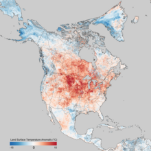
Land surface temperatures of March 8-15, 2012. Land surface temperatures are distinct from the air temperatures that meteorological stations typically measure. North American Temperature Anomaly March 2012.png
Land surface temperatures of March 8–15, 2012. Land surface temperatures are distinct from the air temperatures that meteorological stations typically measure.

In March 2012, one of the greatest heat waves was observed in many regions of North America. Very warm air pushed northward west of the Great Lakes region, and subsequently spread eastward. The intense poleward air mass movement was propelled by an unusually intense low level southerly jet that stretched from Louisiana to western Wisconsin. Once this warm surge inundated the area, a remarkably prolonged period of record setting temperatures ensued. [1]

Contents

NOAA's National Climate Data Center reported that over 7,000 daily record high temperatures were tied or broken from 1 March through 27 March. [1] In some places the temperature exceeded 86 °F (30 °C). For instance, in Grand Rapids, Michigan, the highest temperature recorded was 87 °F (31 °C) on March 21; in Chicago a high of 87 °F was also recorded on that same day. Records were broken in unusual ways. Chicago, for example, saw temperatures above 80 °F (27 °C) every day between March 14–18, breaking records on all five days. Chicago would go on to record eight days at or above 80 °F during the month, with many suburban areas recording an additional day in the 80s on March 19 (that day, the city only tied its record high of 78 °F (26 °C)). In context, the National Weather Service's Chicago branch noted that Chicago typically averages only one day in the 80's in April. And only once in 140 years of weather observations has April produced as many 80 °F days as this March. [2]

Temperature records across much of southern Canada also were shattered. [2] Some of the most impressive readings came from Nova Scotia on March 22, when the mercury climbed to 30.0 °C (86 °F) at a climate station in Lake Major, [3] making it the highest March temperature recorded in Nova Scotia, and the third highest March temperature recorded in Canada. That same day, the temperature hit 29.2 °C (84.6 °F) at Western Head, Nova Scotia. [4] The heat reached as far east as Cape Breton Island, with the temperature climbing to 24.0 °C (75.2 °F) at Sydney, Nova Scotia, on March 22, [5] a place historically surrounded by ice-jammed waters, frigid winds, and snow in March. The week of March 18 also set record temperatures in Manitoba and much of Ontario [6] as well as into the Maritime Provinces. [7] [8] [9] Non-severe thunderstorms were reported on the evening hours of March 21, through to the early morning hours March 22 into northern Ontario.

In addition, NCEP/NCAR Reanalysis data show that the atmospheric pattern was so persistent that much of the Midwest and Northeast, and up into Ontario, had temperature departures over periods of several days to a week or more of magnitudes which would be unusual even for a single day. Averaged over the seven-day period from March 16 to March 22 inclusive, nearly the entire area of the Midwest and Northeast U.S. and most of Ontario and Quebec had temperatures 18 °F (10 °C) or more above the 1981-2010 average. Even more dramatically, most of Iowa and Minnesota, all of Wisconsin and Michigan, and most of southeastern Ontario had seven-day mean temperatures more than 27 °F (15 °C) above the climatological average for the same period. [10] [11] [12] [13] [14] [15]

An 84 °F (29 °C) high at Madison, Wisconsin in early March was 43 °F (24 °C) above average and followed an overnight low of 60 °F (16 °C), 35 °F (19 °C) above normal [16] the daily high being more than seven standard deviations above the mean. The absolute temperature and departure statistically would be equivalent to a mid-July high at that station in excess of 125 °F (52 °C); the highest temperature recorded there was 107 °F (42 °C) at least once during the heat waves of the middle 1930s. [17]

The warm weather was also responsible for several early-season tornado touchdowns, such as the EF3 that struck Dexter, Michigan, near Ann Arbor. [18] [19]

Causes

The contiguous US saw above normal temperatures in the winter of 2011-12, with numerous northern states surpassing 50degF on January 31st. U.S. temp map 2012-01-31.png
The contiguous US saw above normal temperatures in the winter of 2011-12, with numerous northern states surpassing 50°F on January 31st.

A contributing factor to the unprecedented warmth was a warmer than average winter with below-average snowfall across the CONUS, meaning less thermal energy was required to heat the atmosphere.

The primary, [20] immediate cause of the heat wave was a buckled jet stream caused by an abnormally strong high pressure ridge atop the Eastern United States and an unusually strong and slow-moving low pressure trough across the West, which brought with it below-average temperatures and snow. The tight pressure gradient allowed for an intense southerly jet to form, which transported warm, humid air from the Gulf of Mexico northward, with the moisture having an insulating effect during the night. The ridge also deflected storm systems northward away from the Eastern U.S. and kept skies clear, allowing further daytime radiative heating to occur.

In addition, the North Atlantic oscillation was in a strongly positive phase during the heat wave, which often foreshadows above average temperatures in the Eastern U.S. The Madden-Julian oscillation also entered a phase correlated with warm temperatures in the U.S. East. [21]

Continued warmth

On June 25, Denver, Colorado, tied its all-time high with a temperature of 105 °F (41 °C). On the same day, at least two readings of 113 °F (45 °C) were recorded in Kansas. The heat was so strong that Alamosa, Colorado, broke its daily record for six consecutive days. In Galveston, Texas, the earliest 100 °F (38 °C) day ever was recorded, on June 25. [22] [23]

In northern Canada, Fort Good Hope, Northwest Territories had five consecutive days of 30 °C (86 °F) or higher, from June 21 to June 25, possibly the longest heat wave in Canada at that moment. [24]

On June 26, Hill City, Kansas, was the warmest point in the United States, with the thermometer climbing to 115 °F (46 °C). [25]

Thousands of records were being broken again on June 28. Fort Wayne, Indiana, tied its all-time record high with 106 °F (41 °C) while Indianapolis broke its monthly record, at 104 °F (40 °C). More monthly records that day included St. Louis, at 108 °F (42 °C) and Little Rock, Arkansas, at 107 °F (42 °C). [26] [ unreliable source? ]

The scorching heat continued on June 29, when Washington, D.C., and Atlanta, Georgia, recorded their highest June temperatures ever, at 104 °F (40 °C). Charlotte and Raleigh, North Carolina, each tied their all-time records, at 104 °F (40 °C) and 105 °F (41 °C) respectively. [27]

The continued heat following the lack of snow the previous winter was a contributor to the record-shattering 2012 North American drought.

Related Research Articles

<span class="mw-page-title-main">Osoyoos</span> Town in British Columbia, Canada

Osoyoos is the southernmost town in the Okanagan Valley in British Columbia between Penticton and Omak. The town is 3.6 km (2.2 mi) north of the United States border with Washington state and is adjacent to the Osoyoos Indian reserve. The origin of the name Osoyoos was the word sw̓iw̓s meaning "narrowing of the waters" in the local Okanagan language (Syilx'tsn). The "O-" prefix is not indigenous in origin and was attached by settler-promoters wanting to harmonize the name with other place names beginning with O in the Okanagan region. There is one local newspaper, the Osoyoos Times.

<span class="mw-page-title-main">Climate of Chicago</span> Hot-summer humid continental climate

The climate of Chicago is classified as hot-summer humid continental with hot humid summers and cold, occasionally snowy winters. All four seasons are distinctly represented: Winters are cold and often see snow with below 0 Celsius temperatures and windchills, while summers are warm and humid with temperatures being hotter inland, spring and fall bring bouts of both cool and warm weather and fairly sunny skies. Annual precipitation in Chicago is moderate and relatively evenly distributed, the driest months being January and February and the wettest July and August. Chicago's weather is influenced during all four seasons by the nearby presence of Lake Michigan.

<span class="mw-page-title-main">Climate of Adelaide</span>

Adelaide has a Mediterranean climate, with mild wet winters and hot dry summers.

<span class="mw-page-title-main">Geography of Toronto</span> Geography of the city of Toronto, Canada

The geography of Toronto, Ontario, covers an area of 630 km2 (240 sq mi) and is bounded by Lake Ontario to the south; Etobicoke Creek, Eglinton Avenue, and Highway 427 to the west; Steeles Avenue to the north; and the Rouge River and the Scarborough–Pickering Townline to the east. In addition to Etobicoke Creek and the Rouge River, the city is trisected by two minor rivers and their tributaries, the Humber River in the west end and the Don River east of downtown. Both flow southward to Lake Ontario at Humber Bay and Toronto Harbour respectively, which are part of the longer Waterfront, as well as Etobicoke Creek and the Rouge River.

<span class="mw-page-title-main">1936 North American heat wave</span> Extreme weather event

The 1936 North American heat wave was one of the most severe heat waves in the modern history of North America. It took place in the middle of the Great Depression and Dust Bowl of the 1930s and caused catastrophic human suffering and an enormous economic toll. The death toll exceeded 5,000, and huge numbers of crops were destroyed by the heat and lack of moisture. Many state and city record high temperatures set during the 1936 heat wave stood until the summer 2012 North American heat wave. Many more endure to this day; as of 2022, 13 state record high temperatures were set in 1936. The 1936 heat wave followed one of the coldest winters on record.

Oklahoma City lies in a temperate humid subtropical climate, with frequent variations in weather daily and seasonally, except during the consistently hot and humid summer months. Consistent winds, usually from the south or south-southeast during the summer, help temper the hotter weather. Consistent northerly winds during the winter can intensify cold periods. Oklahoma City's climate transitions toward semi-arid further to the west, toward humid continental to the north, and toward humid subtropical to the east and southeast. The normal annual mean temperature is 61.4 °F (16.3 °C); the coolest year was 1895 with a mean of 57.9 °F (14.4 °C), while the warmest 2012 at 64.1 °F (17.8 °C). Precipitation averages 36.52 inches (928 mm) annually, falling on an average 84 days, with the warmer months receiving more; annual precipitation has historically ranged from 15.74 in (400 mm) in 1901 to 56.95 in (1,447 mm) in 2007. The sun shines about 69% of the time, with monthly percent possible sunshine ranging from 60% in December to 80% in July.

<span class="mw-page-title-main">Climate of Minnesota</span> Climatic conditions of Minnesota, US

Minnesota has a humid continental climate, with hot summers and cold winters. Minnesota's location in the Upper Midwest allows it to experience some of the widest variety of weather in the United States, with each of the four seasons having its own distinct characteristics. The area near Lake Superior in the Minnesota Arrowhead region experiences weather unique from the rest of the state. The moderating effect of Lake Superior keeps the surrounding area relatively cooler in the summer and warmer in the winter, giving that region a smaller yearly temperature variation. On the Köppen climate classification, much of the southern third of Minnesota—roughly from the Twin Cities region southward—falls in the hot summer zone (Dfa), and the northern two-thirds of Minnesota falls in the warm summer zone (Dfb).

<span class="mw-page-title-main">Climate of Illinois</span>

The Climate of Illinois describes the weather conditions, and extremes, noted within the state of Illinois, United States, over time.

<span class="mw-page-title-main">Climate of New York (state)</span> Overview of the climate of the U.S. state of New York

The climate of New York (state) is generally humid continental, while the extreme southeastern portion of the state lies in the warmer humid subtropical climate zone. Winter temperatures average below freezing during January and February in much of the state of New York, but several degrees above freezing along the Atlantic coastline, including New York City.

<span class="mw-page-title-main">Climate of Miami</span> Overview of the climate of Miami

The climate of Miami is classified as having a tropical monsoon climate with hot and humid summers; short, warm winters; and a marked drier season in the winter. Its sea-level elevation, coastal location, position just above the Tropic of Cancer, and proximity to the Gulf Stream shape its climate.

The 2011 North American heat wave was a deadly summer 2011 heat wave that affected the Southern Plains, the Midwestern United States, Eastern Canada, the Northeastern United States, and much of the Eastern Seaboard, and had Heat index/Humidex readings reaching upwards of 131 °F (55 °C). On a national basis, the heat wave was the hottest in 75 years.

<span class="mw-page-title-main">2012 North American heat wave</span> Weather event in North America

The Summer 2012 North American heat wave was one of the most severe heat waves in modern North American history. It resulted in more than 82 heat-related deaths across the United States and Canada, and an additional twenty-two people died in the resultant June 2012 North American derecho. This long-lived, straight-line wind and its thunderstorms cut electrical power to 3.7 million customers. Over 500,000 were still without power on July 6, as the heat wave continued. Temperatures generally decreased somewhat the week of July 9 in the east, but the high pressure shifted to the west, causing the core of the hot weather to build in the Mountain States and the Southwestern United States shifting eastwards again by mid-July. By early August, the core of the heat remained over the Southern Plains.

<span class="mw-page-title-main">1994 North American cold wave</span> Weather event

The 1994 North American cold wave occurred over the midwestern and eastern regions of the United States and southern Canada in January 1994. The cold wave caused over 100 deaths in the United States. Two notable cold air events took place from January 18–19 and January 21–22. There were 67 minimum temperature records set on January 19. During this time, much of the United States experienced its coldest temperatures since a major storm on February 20, 1934.

<span class="mw-page-title-main">Climate of Nova Scotia</span>

Nova Scotia lies in the mid-temperate zone, and although the province is almost surrounded by water, the climate is closer to continental climate rather than maritime climate. The temperature extremes of the continental climate are moderated by the ocean.

<span class="mw-page-title-main">January–March 2014 North American cold wave</span> Extreme weather event affecting parts of Canada and the United States

The January–March 2014 North American cold wave was an extreme weather event that extended through the late winter months of the 2013–2014 winter season, and was also part of an unusually cold winter affecting parts of Canada and parts of the north-central and northeastern United States. The event occurred in early 2014 and was caused by a southward shift of the North Polar Vortex. Record-low temperatures also extended well into March.

<span class="mw-page-title-main">2013–14 North American winter</span>

The 2013–14 North American winter was one of the most significant for the United States, due in part to the breakdown of the polar vortex in November 2013, which allowed very cold air to travel down into the United States, leading to an extended period of very cold temperatures. The pattern continued mostly uninterrupted throughout the winter and numerous significant winter storms affected the Eastern United States, with the most notable one being a powerful winter storm that dumped ice and snow in the Southeastern United States and the Northeastern United States in mid-February. Most of the cold weather abated by the end of March, though a few winter storms did affect the Western United States towards the end of the winter.

The 2018 North American heat wave affected regions of Canada, where at least 70 deaths in Quebec were heat-related, the United States, where 18 states between Michigan and New Mexico issued heat advisories to a population of over 60 million people, and of Mexico, particularly the northwest and central regions.
<span class="mw-page-title-main">January–February 2019 North American cold wave</span> Fatal cold wave in the US and Canada

In late January 2019, a severe cold wave caused by a weakened jet stream around the Arctic polar vortex hit the Midwestern United States and Eastern Canada, killing at least 22 people. It came after a winter storm brought up to 13 inches (33 cm) of snow in some regions from January 27–29, and brought the coldest temperatures in over 20 years to most locations in the affected region, including some all-time record lows. In early February, a concentration of Arctic air colloquially referred to as the "polar vortex" moved west, and became locked over Western Canada and the Western United States. As a result, February 2019 was among the coldest and snowiest on record in these regions. In early March, the cold once again shifted east, breaking records in many areas. In mid-March, the cold wave finally retreated, but combined with above-average temperatures, precipitation, and a deep snowpack, widespread flooding ensued in the Central US.
References

  1. 1 2 Meteorological March Madness 2012, Earth System Research Laboratories , 02 April 2012
  2. 1 2 "Historic Heat in North America Turns Winter to Summer". NASA Earth Observatory. NASA. 21 March 2012. Retrieved 23 March 2012.
  3. "Daily Data". Climate.weatheroffice.gc.ca. 2013-08-27. Retrieved 2013-10-06.
  4. "Daily Data". Climate.weatheroffice.gc.ca. 2013-08-27. Retrieved 2013-10-06.
  5. "Daily Data". Climate.weatheroffice.gc.ca. 2013-08-27. Retrieved 2013-10-06.
  6. Ontario Weather Review - Environment Canada - March 2012
  7. 'Winter that wasn't' ends with Eastern heat wave', Calgary Herald , March 20, 2012
  8. Summer-like weather smashing winter records, CTV News , March 19, 2012
  9. Canada's Top Ten Weather Stories for 2012. 4. March’s Meteorological Mildness, Environment Canada, 2012
  10. ESRL Web Team. "ESRL : PSD : Composite Daily Data Plot". Esrl.noaa.gov. Retrieved 2013-05-20.
  11. "Image provided by the NOAA/ESRL Physical Sciences Division, Boulder Colorado". Esrl.noaa.gov. Retrieved 2013-10-06.
  12. Kalnay, E. and Coauthors, 1996: The NCEP/NCAR Reanalysis 40-year Project. Bull. Amer. Meteor. Soc., 77, 437-471.
  13. Amazing Stats from the March 2012 'Heat Wave', Accuweather , March 24, 2012
  14. Toronto heat wave comes close to hottest March day on record, Toronto Star , March 22, 2012
  15. Epic March heat wave in Midwest, Great Lakes and Northeast: link to global warming?, Washington Post , March 22, 2012
  16. http://www.aos.wisc.edu/~sco/clim-history/stations/msn/msn-tts-2012.gif [ bare URL image file ]
  17. analysis of raw data, file at:
  18. Tornado slams Michigan homes, spares lives, CBS News , March 16, 2012
  19. More than 100 homes damaged by Mich. tornado, USA Today , March 16, 2012
  20. unsupported
  21. Borth, Samantha. "The Historic March 2012 Heat Wave: A Meteorological Retrospective" (PDF). NOAA. Retrieved 9 February 2020.
  22. "climate_gls_normals_jun". Archived from the original on 2015-09-24.
  23. "All-Time Record Highs Fall in Colorado, Kansas, Nebraska". Accuweather.com. Retrieved 2013-05-20.
  24. "Daily Data | Canada's National Climate Archive". Climate.weatheroffice.gc.ca. 2013-02-04. Archived from the original on 2012-12-16. Retrieved 2013-05-20.
  25. "Hill City" . Retrieved June 28, 2012.[ dead link ]
  26. "STORM2K • View topic - RECORD HIGHS JUNE 2012". Storm2k.org. Retrieved 2013-05-20.
  27. Samenow, Jason (2012-06-29). "Washington, D.C. shatters all-time June record high, sizzles to 104 - Capital Weather Gang". The Washington Post. Retrieved 2013-05-20.