
The West Somerset Railway (WSR) is a 22.75-mile (36.6 km) heritage railway line in Somerset, England. The freehold of the line and stations is owned by Somerset County Council; the railway is leased to and operated by West Somerset Railway plc ; which is supported and minority-owned by charitable trust the West Somerset Railway Association (WSRA) and the West Somerset Steam Railway Trust (WSSRT). The WSR plc operates services using both heritage steam and diesel trains.
Sturminster Newton is a town and civil parish in the Blackmore Vale area of Dorset, England. It is situated on a low limestone ridge in a meander of the River Stour. The town is at the centre of a large dairy agriculture region, around which the town's economy is built. The larger part of the town (Sturminster) lies on the north side of the river, and includes most shops and services, whilst to the south is the smaller Newton. Between these two areas is a wide flood plain. The town was the home of poet and author William Barnes, and, for part of his life, Thomas Hardy. The town has 43 shops, a primary and secondary school, and a school and college catering for children with Special educational needs. In the 2011 census the town's civil parish had a population of 5,234.

Cadbury Castle is a Bronze and Iron Age hillfort in the civil parish of South Cadbury in the English county of Somerset. It is a scheduled monument and has been associated with King Arthur's legendary court at Camelot.

The Somerset and Dorset Joint Railway, also known as the S&D, SDJR or S&DJR, was an English railway line connecting Bath and Bournemouth, with a branch from Evercreech Junction to Burnham-on-Sea and Bridgwater. Strictly speaking, the main line ran from Bath Junction to Broadstone, as the line between Broadstone and Bournemouth was owned by the London and South Western Railway, while the line between Bath Junction and Bath was owned by the Midland Railway.

Spetisbury is a village and civil parish in north Dorset, England, situated on the River Stour and the A350 road, four miles southeast of Blandford Forum. In the 2011 census the civil parish had 224 households and a population of 555.

Hod Hill is a large hill fort in the Blackmore Vale, 3 miles (5 km) north-west of Blandford Forum, Dorset, England. The fort sits on a 143 m (469 ft) chalk hill of the same name that lies between the adjacent Dorset Downs and Cranborne Chase. The hill fort at Hambledon Hill is just to the north. The name probably comes from Old English "hod", meaning a shelter, though "hod" could also mean "hood", referring to the shape of the hill.

The Somerset & Dorset Railway Heritage Trust (S&DRHT) is a heritage railway line in Somerset, England, that runs on a restored section of the Somerset and Dorset Joint Railway. The line is approximately 1 mile long and operates from Midsomer Norton South.
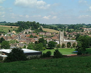
Bruton is a market town, electoral ward, and civil parish in Somerset, England, on the River Brue and the A359 between Frome and Yeovil. It is 7 miles south-east of Shepton Mallet, just south of Snakelake Hill and Coombe Hill, 10 miles north-west of Gillingham and 12 miles south-west of Frome in South Somerset district. The town and ward have a population of 2,907. The parish includes the hamlets of Wyke Champflower and Redlynch. Bruton has a museum of items from the Jurassic era onwards.

Ashwick is a village in the Mendip district of Somerset, England, about three miles north of Shepton Mallet and seven miles east from Wells. It has also been a civil parish since 1826. The parish had a population of 1,352 according to the 2011 census, and apart from Ashwick village also includes Gurney Slade and Oakhill.

St Cuthbert Out, sometimes Wells St Cuthbert Out, is a civil parish in the Mendip district of Somerset, England. It entirely surrounds the city and parish of Wells. According to the 2011 census it had a population of 3,749.
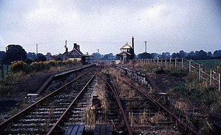
Binegar railway station was a station on the Somerset and Dorset Joint Railway in the county of Somerset in England. Opened on 20 July 1874, the station consisted of two platforms, with a building on the down platform. There was a substantial goods yard with two sheds and sidings, controlled from a 24 lever signal box. Being the first station north of the line's summit at Masbury Binegar was also where locomotives used as banking engines on north-bound trains would drop off and cross the line ready to return south.
Maesbury Railway Cutting is a 2 hectare geological Site of Special Scientific Interest between East Horrington and Gurney Slade in Somerset, notified in 1995.

Maesbury Castle is an Iron Age hill fort within the parish of Croscombe on the Mendip Hills, just north of Shepton Mallet, Somerset, England. It has been listed as a Scheduled Ancient Monument.
The Mendip Way is an 80-kilometre (50 mi) long-distance footpath across the Mendip Hills from Weston-super-Mare to Frome. It is divided into two sections.

The West Somerset Coast Path is a long-distance footpath that links the northern end of the South West Coast Path to the River Parrett Trail in Somerset, England, UK.
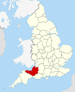
The county of Somerset is in South West England, bordered by the Bristol Channel and the counties of Bristol and Gloucestershire to the north, and Wiltshire to the east, Dorset to the south, and Devon to the west. The climate, influenced by its proximity to the Atlantic Ocean and the prevailing westerly winds, tends to be mild, damp and windy.

The Yeovil Scarplands are a natural region in southern England in the counties of Somerset and Dorset.

St Brides Major is a community on the western edge of the Vale of Glamorgan, South Wales. Its largest settlement is the village of St Brides Major, and also includes the villages of Ogmore-by-Sea and Southerndown, and the hamlets of Ogmore Village, Castle-upon-Alun, Heol-y-Mynydd, Norton and Pont-yr-Brown It is notable for coastal geology and scenery, limestone downlands and fossilised primitive mammals, sea cliffs and beaches, two Iron Age hillforts, three medieval castle sites,, two stepping stone river crossings and a clapper bridge. Three long distance paths cross the community. It is the western limit of the Vale of Glamorgan Heritage Coast, and has a visitor centre and tourist facilities.

There are over 670 scheduled monuments in the ceremonial county of Somerset in South West England. The county consists of a non-metropolitan county, administered by Somerset County Council, which is divided into five districts, and two unitary authorities. The districts of Somerset are West Somerset, South Somerset, Taunton Deane, Mendip and Sedgemoor. The two administratively independent unitary authorities, which were established on 1 April 1996 following the breakup of the county of Avon, are North Somerset and Bath and North East Somerset. These unitary authorities include areas that were once part of Somerset before the creation of Avon in 1974.
