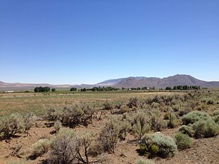
Denio is a census-designated place (CDP) in Humboldt County, Nevada, along the Oregon state line in the United States. The Denio post office was originally north of the state line in Harney County, Oregon, but the residents moved the building into Nevada in the mid-20th century. The population of the CDP, which is entirely in Nevada, was 47 at the 2010 census; additional development considered to be Denio extends into Oregon. The CDP includes a post office, a community center, a library, and the Diamond Inn Bar, the center of the town's social life. Recreational activities in the Denio area include bird watching, photography, off road vehicle use, fishing, recreational black opal mining, rockhounding, hunting, visiting the hot springs, and camping on the Sheldon National Wildlife Refuge.
Lee is an unincorporated community in Elko County, Nevada, United States. The community is located on the reservation land belonging to, and constituting the sole organized community of, the South Fork Band of the Te-Moak Tribe of Western Shoshone Indians of Nevada. Lee is located at the western foothills of the Ruby Mountains range, within the Elko Micropolitan Statistical Area.

North Fork is an unincorporated community in Elko County, Nevada, United States. The ZIP Code of North Fork, Nevada is 89801.

Mill City is an unincorporated community in Pershing County, Nevada, United States. The ZIP Code of Mill City is 89418.
Contact is an unincorporated community in Elko County, Nevada, United States. It is located on a mineral-rich granite intrusion and there are many mines nearby.

San Jacinto is a ghost town in along Salmon Falls Creek in northern Elko County, Nevada, United States. It is part of the Elko Micropolitan Statistical Area.
Cobre is a ghost town in Elko County, Nevada, United States.
Wellington is an unincorporated town in southwestern Lyon County, Nevada, United States. It lies along State Route 208, southwest of the city of Yerington, the county seat of Lyon County. Its elevation is 4,836 feet (1,474 m). Wellington has a post office with the ZIP code 89444,
Arthur is an unincorporated community and ghost town in Nevada, United States.
Deerlick is an unincorporated community in Mason County, West Virginia, United States. Deerlick is located at the junction of County Routes 31 and 60, 5.7 miles (9.2 km) east of Leon. The community once had a post office, which is now closed.
Pondlick is an unincorporated community in Mason County, West Virginia, United States. Pondlick is located at the junction of County Routes 54 and 56, 9.1 miles (14.6 km) south of Point Pleasant. The community once had a post office, which is now closed.
Ben Lomond is an unincorporated community in Mason County, West Virginia, United States. It is located on the Ohio River at the junction of West Virginia Route 2 and County Route 56,, some 9.7 miles (15.6 km) south-southwest of Point Pleasant.
Hogsett is an unincorporated community on the east bank of the Ohio River in Mason County, West Virginia, United States. It is located on West Virginia Route 2, some 10.7 miles (17.2 km) south-southwest of Point Pleasant at the mouth of Flatfoot Creek. The community once had a post office, which is now closed.
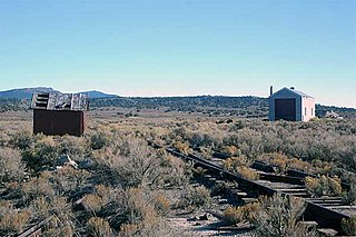
Rowland is a ghost town in northern Elko County, Nevada, United States.
Mason Springs is an unincorporated community in Charles County, Maryland, United States. Mason Springs is located at the junction of Maryland routes 224 and 225, 1.8 miles (2.9 km) southeast of Potomac Heights. The community had a post office from 1890 to 1924.
Pyramid is an unincorporated community in Washoe County, Nevada, United States. At one time, it was a station on the Fernley and Lassen Railway located between Bristol and Big Canyon. There was a post office at this location from March 1904 until November 1959.
Minerva is an unincorporated community in Mason County, Kentucky, United States.
Huntington is a ghost town in Elko County, Nevada, United States.

Gold Creek is an extinct town in Elko County, Nevada, United States.
Spilman is an unincorporated community on the Ohio River in Mason County, West Virginia, United States. The village is located along Spilman Lane, Mason County Route 62/24, parallel to West Virginia Route 62 in Waggener District, about three quarters of a mile southeast of West Columbia.


