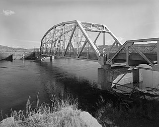
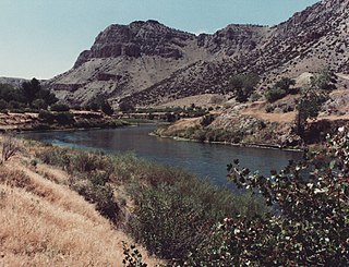
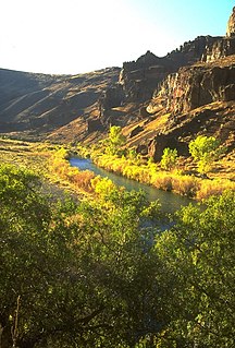
The Bighorn River is a tributary of the Yellowstone, approximately 461 miles (742 km) long, in the states of Wyoming and Montana in the western United States. The river was named in 1805 by fur trader François Larocque for the bighorn sheep he saw along its banks as he explored the Yellowstone.

The Little Bighorn River is a 138-mile-long (222 km) tributary of the Bighorn River in the United States in the states of Montana and Wyoming. The Battle of the Little Bighorn, also known as the Battle of the Greasy Grass, was fought on its banks on June 25–26, 1876, as well as the Battle of Crow Agency in 1887.

The Bighorn Mountains are a mountain range in northern Wyoming and southern Montana in the United States, forming a northwest-trending spur from the Rocky Mountains extending approximately 200 mi (320 km) northward on the Great Plains. They are separated from the Absaroka Range, which lie on the main branch of the Rockies to the west, by the Bighorn Basin. Much of the land is contained within the Bighorn National Forest.

Powder River is a tributary of the Yellowstone River, approximately 375 miles (604 km) long in northeastern Wyoming and southeastern Montana in the United States. Combined with its tributary, the South Fork Powder River, it is 550 miles long. It drains an area historically known as the Powder River Country on the high plains east of the Bighorn Mountains.
The Wind River is the name applied to the upper reaches of the Bighorn River in Wyoming in the United States. The Wind River is 185 miles (298 km) long. The two rivers are sometimes referred to as the Wind/Bighorn.
The Owyhee River is a tributary of the Snake River located in northern Nevada, southwestern Idaho and southeastern Oregon in the United States. It is 280 miles (450 km) long. The river's drainage basin is 11,049 square miles (28,620 km2) in area, one of the largest subbasins of the Columbia Basin. The mean annual discharge is 995 cubic feet per second (28.2 m3/s), with a maximum of 50,000 cu ft/s (1,400 m3/s) recorded in 1993 and a minimum of 42 cu ft/s (1.2 m3/s) in 1954.

The Nooksack River is a river in western Whatcom County of the northwestern U.S. state of Washington, draining extensive valley systems within the North Cascades around Mount Shuksan, Mount Baker and the Twin Sisters, and a portion of Fraser Lowland south of the Canada–United States border.

The Sauk River is a tributary of the Skagit River, approximately 45 miles (72 km) long, in northwestern Washington in the United States. It drains an area of the high Cascade Range in the watershed of Puget Sound north of Seattle. The river is a popular destination for fly fishing. It is a National Wild and Scenic River.

The Skokomish River is a river in Mason County, Washington, United States. It is the largest river flowing into Hood Canal, a western arm of Puget Sound. From its source at the confluence of the North and South Forks the main stem Skokomish River is approximately 9 miles (14 km) long. The longer South Fork Skokomish River is 40 miles (64 km), making the length of the whole river via its longest tributary about 49 miles (79 km). The North Fork Skokomish River is approximately 34 miles (55 km) long. A significant part of the Skokomish River's watershed is within Olympic National Forest and Olympic National Park.

State Route 228 (SR 228), also known as Jiggs Highway, is a 20.803-mile (33.479 km) state highway in Elko County, Nevada, United States, that connects Jiggs with Nevada State Route 227 in Spring Creek.

The Pease River is a river in Texas, United States. It is a tributary of the Red River that runs in an easterly direction through West Texas. It was discovered and mapped for the first time in 1856 by Jacob de Córdova, who found the river while surveying for the Galveston, Houston and Henderson Railroad Company; it was named after Texas Governor Elisha M. Pease. In December 1860, the Texas Rangers recaptured Cynthia Ann Parker and her daughter from the Comanche Indians at an engagement along the river.

The Bridger Trail, also known as the Bridger Road and Bridger Immigrant Road, was an overland route connecting the Oregon Trail to the gold fields of Montana. Gold was discovered in Virginia City, Montana in 1863, prompting settlers and prospectors to find a trail to travel from central Wyoming to Montana. In 1863, John Bozeman and John Jacobs scouted the Bozeman Trail, which was a direct route to the Montana gold fields through the Powder River Country. At the time the region was controlled by the Sioux, Cheyenne and Arapaho, who stepped up their raids in response to the stream of settlers along the trail.

The South Fork Kern River is a tributary of the Kern River in the Sierra Nevada of the U.S. state of California. It is one of the southernmost rivers on the western slope of the mountains, and drains a high, relatively dry plateau country of 982 square miles (2,540 km2) along the Sierra Crest. The upper South Fork flows through a series of rugged canyons, but it also drains a flat, marshy valley before joining the Kern River at Lake Isabella.

Blacks Fork is a 175-mile-long (282 km) tributary of the Green River in Utah and Wyoming in the United States.
Banner is an unincorporated community in southern Sheridan County, Wyoming, United States. It lies near Interstate 90, south of the city of Sheridan, the county seat of Sheridan County. Its elevation is 4,580 feet (1,400 m). Although Banner is unincorporated, it had a post office, with the ZIP code of 82832, which closed in 2004. Public education in the community of Banner is provided by Sheridan County School District #2.
The New Fork River is the uppermost major tributary of the Green River in Wyoming, flowing about 70 miles (110 km) entirely within Sublette County. It drains an arid farming region of southwestern Wyoming south of the Wind River Range.

Fort McKinney (1877–1894) was a military post located in North Eastern Wyoming, near the Powder River.
Big Trails is an unincorporated place in the eastern part of Washakie County in north-central Wyoming. Wyoming Highway 434 leads north 21 miles to Ten Sleep, and south over mountains to Lost Cabin, Lysite, and Moneta. Barnum and Mayoworth are the nearest places to the east across the Bighorn range.
Barnum is an unincorporated place in the southwestern part of Johnson County in north-central Wyoming, United States. It lies in the eastern valleys of the Bighorn Mountains. Barnum is at the western terminus of Wyoming Highway 190, approximately 17 miles west of the Kaycee exit off Interstate 25.
Border Junction or Border is a populated place and road intersection in the far western part of Lincoln County, Wyoming, United States. US Route 30 is the major road, which leads northwest to Montpelier, Idaho, in Bear Lake County, and southeast to Cokeville. Wyoming Highway 89 runs north toward US Route 89, and southeast concurrently with US 30. Lincoln County Road 134 runs briefly south toward some homes and ranches. The Union Pacific Railroad passes Border Junction in the direction of Rock Springs to the east and Pocatello, Idaho, to the west.

