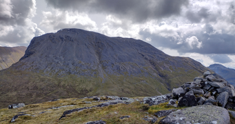
Ben Nevis is the highest mountain in Scotland, the United Kingdom and the British Isles. The summit is 4,411 feet (1,345 m) above sea level and is the highest land in any direction for 459 miles. Ben Nevis stands at the western end of the Grampian Mountains in the Highland region of Lochaber, close to the town of Fort William.

Rannoch Moor is an expanse of around 50 square miles (130 km2) of boggy moorland to the west of Loch Rannoch in Scotland, where it extends from and into westerly Perth and Kinross, northerly Lochaber, and the area of Highland Scotland toward its south-west, northern Argyll and Bute. Rannoch Moor is designated a Site of Special Scientific Interest (SSSI) and a Special Area of Conservation. Much of the western part of the moor lies within the Ben Nevis and Glen Coe National Scenic Area, one of 40 such areas in Scotland.
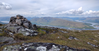
Glen Coe is a glen of volcanic origins, in the Highlands of Scotland. It lies in the north of the county of Argyll, close to the border with the historic province of Lochaber, within the modern council area of Highland. Glen Coe is regarded as the home of Scottish mountaineering and is popular with hillwalkers and climbers.

The Aonach Eagach is a large mountain ridge in the Scottish Highlands, marking the northern edge of Glen Coe. It stretches east–west for several miles and includes two Munro summits: Sgùrr nam Fiannaidh at 967 m (3,175 ft) high, and Meall Dearg at 952 m (3,124 ft) high. The ridge is very rocky and the route along it requires scrambling ability. The slopes to each side are extremely dangerous, with steep grass-and-scree slopes hiding even steeper slopes which end in cliffs on both north and south sides of the ridge.

Ben Macdui is the second-highest mountain in Scotland and all of the British Isles, after Ben Nevis, and the highest of the Cairngorm Mountains. The summit is 1,309 metres (4,295 ft) above sea level and it is classed as a Munro. Ben Macdui sits on the southwestern edge of the Cairngorm plateau, overlooking the Lairig Ghru pass to the west, and Loch Etchachan to the east. It lies on the boundary between the historic counties of Aberdeenshire and Banffshire.
Ben Lawers is the highest mountain in the Breadalbane region of the Scottish Highlands. It lies north of Loch Tay and is the highest peak of the 'Ben Lawers group', a ridge that includes six other Munros: Beinn Ghlas, Meall Garbh, Meall Corranaich, An Stùc, Meall Greigh and Meall a' Choire Leith. It is also the highest peak in Perthshire, and the tenth highest Munro in Scotland. Ben Lawers was long thought to be over 4000 feet in height; accurate measurement in the 1870s showed it to be 3,983 feet (1,214 m).

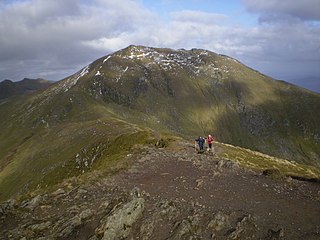
Bidean nam Bian is the highest peak in a group of mountains south of Glen Coe and north of Glen Etive in the Scottish Highlands. With a height of 1,150 metres (3,770 ft), it is a Munro and the highest point in Argyll. It is a complex mountain, with many ridges and subsidiary peaks, one of which, Stob Coire Sgreamhach, is classified as a separate Munro.
Glen Etive is a glen in the Highlands of Scotland. The River Etive rises on the peaks surrounding Rannoch Moor, with several tributary streams coming together at the Kings House Hotel, at the head of Glen Coe. From the Kings House, the Etive flows for about 18 km, reaching the sea loch, Loch Etive. The river and its tributaries are popular with whitewater kayakers and at high water levels it is a test piece of the area and a classic run.
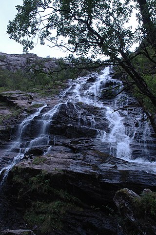
Glen Nevis is a glen in Lochaber, Highland, Scotland, with Fort William at its foot. It is bordered to the south by the Mamore range, and to the north by the highest mountains in the British Isles: Ben Nevis, Càrn Mor Dearg, Aonach Mòr, and Aonach Beag. It is home to one of the three highest waterfalls in Scotland, Steall Falls, where the Allt Coire a'Mhail joins the Water of Nevis in the glen. Below the waterfall is a steeply walled and impressive gorge. The scenic beauty of the glen has led to its inclusion in the Ben Nevis and Glen Coe National Scenic Area, one of 40 such areas in Scotland.

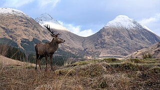
Meall a' Bhùiridh (IPA:[ˈmauɫ̪ˈaˈvuːɾʲɪʝ]) is a mountain on the edge of Rannoch Moor in the Highlands of Scotland. It lies near the top of Glen Coe and Glen Etive, overlooking the Kings House Hotel inn and the A82 road. The Glencoe Ski area is located on the northern slopes of the peak.

Mullach nan Coirean or Sgùrr a' Chaorainn is one of the Mamores mountains in the Scottish Highlands. It reaches a height of 939 metres (3081 feet) and is the most westerly of the ten Munros in the Mamores. It has a lower peak to the west, Meall a' Chaorainn. To the east, it is linked to the neighbouring mountain Stob Bàn by a bealach at a height of 846 metres; these two Munros are often climbed together from Glen Nevis.

Sròn a’ Choire Ghairbh is a Scottish mountain situated on the northern side of Loch Lochy, 13 kilometres north of Spean Bridge in the Highland Council area.

Meall na Teanga is a Scottish mountain located in the Highland council area, 11 km (7 mi) north of Spean Bridge.

Meall a' Chrasgaidh is a Scottish mountain located in the Fannich group of mountains, 21 kilometres south-southeast of Ullapool.

Meall Glas is a mountain situated in the southern highlands of Scotland. It stands on the northern border of the Loch Lomond and the Trossachs National Park, 8.5 kilometres north east of Crianlarich.

Ben Tee is a Scottish mountain situated in the Lochaber area of the Highland council area, some 15 kilometres north of Spean Bridge. It is rated as one of the best of Scotland's smaller mountains with Hamish Brown saying:
Ben Tee is such a shapely cone that it is instantly recognisable from anywhere around the Great Glen or along the Garry. Its isolated situation makes it one of Scotland’s finest summit viewpoints.

Càrn Gorm is a mountain in the Breadalbane region of the Scottish Highlands, with a height of 1,029 metres (3,376 ft). It stands in a group of four Munro mountains known as the Càrn Mairg group or the Glen Lyon Horseshoe, on the north side of Glen Lyon, Perthshire.

Black Mount is a mountain range located in Argyll and Bute, Scotland. It is situated between Glen Orchy and Glen Coe. Its four Munros include Stob Ghabhar, Stob a' Choire Odhair, Creise and Meall a' Bhuiridh. The hills of Ben Inverveigh and Meall Tairbh are located between Black Mount and the Bridge of Orchy.

Beinn Bhàn is a Scottish mountain situated in the Lochaber region of the Highland Council Area. It stands 6 miles (10 km) north-west of Spean Bridge. The hill is not to be confused with another and better known Beinn Bhàn on the Applecross peninsula.
Ben Nevis and Glen Coe is a national scenic area (NSA) covering part of the Highlands of Scotland surrounding Ben Nevis and Glen Coe, in which certain forms of development are restricted. It is one of 40 such areas in Scotland, which are defined so as to identify areas of exceptional scenery and to ensure its protection from inappropriate development. The Ben Nevis and Glen Coe NSA covers 903 km2 (349 sq mi) of land, lying within the Highland, Argyll and Bute and Perth and Kinross council areas. A further 19 km2 (7.3 sq mi) of the NSA are marine, covering the sea loch of Loch Leven.