
The 1999 Atlantic hurricane season was a fairly active season, mostly due to a persistent La Niña that developed in the latter half of 1998. It had five Category 4 hurricanes – the highest number recorded in a single season in the Atlantic basin, previously tied in 1933 and 1961, and later tied in 2005 and 2020. The season officially began on June 1, and ended on November 30. These dates conventionally delimit the period of each year when most tropical cyclones form in the Atlantic basin. The first storm, Arlene, formed on June 11 to the southeast of Bermuda. It meandered slowly for a week and caused no impact on land. Other tropical cyclones that did not affect land were Hurricane Cindy, Tropical Storm Emily, and Tropical Depression Twelve. Localized or otherwise minor damage occurred from Hurricanes Bret, Gert, and Jose, and tropical storms Harvey and Katrina.

The 2005 Atlantic hurricane season was an event in the annual tropical cyclone season in the north Atlantic Ocean. It was the second most active Atlantic hurricane season in recorded history, and the most extreme in the satellite era. Officially, the season began on June 1, 2005 and ended on November 30, 2005. These dates, adopted by convention, historically delimit the period in each year when most tropical systems form. The season's first storm, Tropical Storm Arlene, developed on June 8. The final storm, Tropical Storm Zeta, formed in late December and persisted until January 6, 2006. Zeta is only the second December Atlantic storm in recorded history to survive into January, joining Hurricane Alice in 1955.

Hurricane Karl was a large and powerful Cape Verde hurricane during the 2004 Atlantic hurricane season. It was the eleventh named storm, eighth hurricane, and the sixth and final major hurricane of the 2004 season. Karl formed on September 16, originating from a strong tropical wave that emerged off the coast of Africa. It rapidly intensified, becoming a major hurricane on two occasions. Karl peaked as a strong Category 4 hurricane on the Saffir-Simpson hurricane scale on September 21 with 145 mph (233 km/h) winds. It weakened as it moved northward, becoming extratropical on September 24 in the north Atlantic before it was absorbed by another system on September 28. The extratropical storm affected the Faroe Islands, but no damage was reported there, nor were there any fatalities.

Hurricane Adolph was the first and one of only two East Pacific hurricanes in May to reach Category 4 strength on the Saffir-Simpson Hurricane Scale since record keeping began in the East Pacific, with the other being Amanda of 2014. Adolph was the first depression of the season, forming on May 25; it became a hurricane three days later. After rapidly intensifying, Adolph became the most powerful storm in terms of maximum sustained winds this season, along with Hurricane Juliette. The storm briefly threatened land before dissipating on June 1, after moving over colder waters.
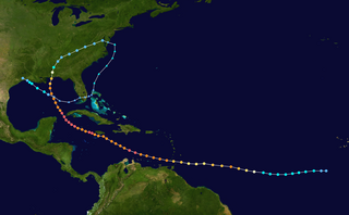
The meteorological history of Hurricane Ivan, the longest tracked tropical cyclone of the 2004 Atlantic hurricane season, lasted from late August through late September. The hurricane developed from a tropical wave that moved off the coast of Africa on August 31. Tracking westward due to a ridge, favorable conditions allowed it to develop into Tropical Depression Nine on September 2 in the deep tropical Atlantic Ocean. The cyclone gradually intensified until September 5, when it underwent rapid deepening and reached Category 4 status on the Saffir-Simpson Hurricane Scale; at the time Ivan was the southernmost major North Atlantic hurricane on record.

The meteorological history of Hurricane Jeanne lasted for about two weeks in September 2004. Hurricane Jeanne was the eleventh tropical cyclone, tenth named storm, seventh hurricane, and sixth major hurricane of the 2004 Atlantic hurricane season. It formed from a tropical wave on September 13 near the Lesser Antilles, and encountered favorable enough conditions to reach tropical storm status. Jeanne strengthened further in the eastern Caribbean, becoming a strong tropical storm and developing an eye before striking Puerto Rico on September 15. Remaining well-organized, it attained hurricane status before hitting the eastern tip of the Dominican Republic on September 16.

The meteorological history of Hurricane Gustav spanned eleven days, from August 25 to September 4, 2008. The tropical disturbance which eventually spawned Hurricane Gustav gathered on August 16, southwest of the Cape Verde islands, but was slow to develop as it trekked west across the Atlantic. Upon reaching the warm waters of Caribbean Sea it began to organize and became a tropical depression on August 25. It quickly strengthened to a tropical storm, and then a hurricane, before making landfall on Haiti's southwest peninsula. Gustav was severely disrupted by Hispaniola's mountains and stalled, disorganized, in the Gulf of Gonâve between August 26 and 27.

The meteorological history of Hurricane Georges spanned seventeen days from September 15 to October 1, 1998. Hurricane Georges began as a tropical wave that moved off the coast of Africa during mid-September 1998. Tracking westward, the wave spawned an area of low pressure two days later, which quickly strengthened into a tropical depression. On September 16, the depression was upgraded to Tropical Storm Georges, and to Hurricane Georges the next day. Over the next few days, an eye developed and deep Atmospheric convection persisted around it. Strong outflow and warm sea surface temperatures allowed the storm to intensify as it tracked towards the west-northwest. The storm reached its peak intensity on September 20 with winds of 155 mph (250 km/h), just below Category 5 status on the Saffir–Simpson hurricane scale, and a barometric pressure of 937 mbar.

Hurricane Rick was the third-most intense Pacific hurricane on record and the second-most intense tropical cyclone worldwide in 2009, only behind Typhoon Nida. Developing off the southern coast of Mexico on October 15, Rick traversed an area with favorable environmental conditions, favoring rapid intensification, allowing it to become a hurricane within 24 hours of being declared a tropical depression. An eye began to form during the afternoon of October 16; once fully formed, the storm underwent another period of rapid strengthening. During the afternoon of October 17, the storm attained Category 5 status on the Saffir–Simpson hurricane wind scale. Several hours later, Rick attained its peak intensity as the third-strongest Pacific hurricane on record with winds of 180 mph (290 km/h) and a barometric pressure of 906 mbar.

Hurricane Maria was a Category 1 hurricane that made landfall on the island of Newfoundland during September 2011. Originating from a tropical wave over the central Atlantic on September 6, Maria moved toward the west and slowly strengthened. While approaching the northern Leeward Islands, however, the system entered a region of higher vertical wind shear and cooler sea surface temperatures, causing it to degenerate into a low-pressure area. It slowly curved toward the north and northeast around the western periphery of the subtropical ridge, and regained tropical storm status on September 10. Maria further strengthened to attain hurricane status while making its closest approach to Bermuda. The cyclone attained peak winds of 80 mph (130 km/h) on September 16, but weakened thereafter because of an increase in wind shear and cooler sea surface temperatures. Maria made landfall on the southeastern coast of Newfoundland during the afternoon hours of September 16 before becoming absorbed by a frontal system later on that same day.

Hurricane Jova was a strong Pacific hurricane that made landfall in Jalisco, Mexico in October 2011. The cyclone was the tenth named storm, ninth hurricane, and fifth major hurricane of the 2011 Pacific hurricane season. Jova developed from a tropical disturbance that formed on October 5. The disturbance steadily organized and acquired more thunderstorm activity over the following hours, and it became a tropical depression early on October 6. It strengthened into Tropical Storm Jova later that day. Moving generally northward, wind shear initially inhibited the system until the establishment of more favorable conditions on October 8 allowed Jova to begin to intensify. It reached hurricane strength that day as it drifted eastwards, and reached major hurricane status on October 10 after a period of steady intensification. Jova reached peak intensity the following day as a high-end Category 3 hurricane, with maximum sustained winds of 125 mph (205 km/h), and a minimum barometric pressure of 955 mbar (28.20 inHg). Jova weakened somewhat as it approached the coastline of Mexico, and made landfall near Barra de Navidad, Jalisco on October 12 as a Category 2 hurricane. The storm rapidly weakened as it moved inland and dissipated the next morning.

The meteorological history of Hurricane Dennis spanned twenty-two days, beginning with its inception as a tropical wave over Africa on June 26, 2005, and terminating with its dissipation on July 18 over the Great Lakes of North America. The incipient wave that became Dennis emerged over the Atlantic Ocean on June 29 and moved briskly to the west. Dry air initially inhibited development, though once this abated the wave was able to consolidate into a tropical depression on July 4. The depression soon crossed Grenada before entering the Caribbean whereupon increasingly favorable environmental factors, such as low wind shear and high sea surface temperatures, fueled intensification. Turning west-northwest, the system achieved tropical storm status on July 5 and hurricane status the following day.
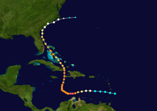
Hurricane Matthew was the first Category 5 Atlantic hurricane since Felix in 2007 and the southernmost Category 5 Atlantic hurricane on record. The system originated from a tropical wave that emerged off the west coast of Africa on September 22, and ultimately dissipated as an extratropical cyclone near Atlantic Canada on October 10. Late on September 29, it began a period of explosive intensification that brought it to Category 5 strength early on October 1. It weakened slightly and remained a Category 4 until its landfalls in Haiti and Cuba, afterwards it traversed through the Bahamas and paralleled the coast of Florida until making landfall in South Carolina as a Category 1 hurricane. Matthew later transitioned into a post-tropical cyclone on October 10.
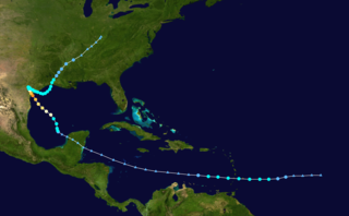
Hurricane Harvey was the costliest tropical cyclone on record, inflicting roughly $125 billion in damage across the Houston metropolitan area and Southeast Texas. It lasted from mid-August until early September 2017, with many records for rainfall and landfall intensity set during that time. The eighth named storm, third hurricane, and first major hurricane of the 2017 Atlantic hurricane season, Harvey originated from a broad area of low pressure southwest of Cape Verde that was first monitored on August 13. Tracking steadily westward, the disturbance developed strong convection, a well-defined circulation, and sustained tropical storm-force winds, leading to the classification of Tropical Storm Harvey late on August 17. Moderate easterly vertical wind shear kept Harvey weak, as it continued westwards into the Caribbean Sea; despite repeated predictions for gradual intensification by the National Hurricane Center, Harvey eventually opened up into a tropical wave on August 19. The remnants of Harvey continued to move westwards and reached the Yucatán Peninsula on August 22, and were forecast to regenerate into a tropical cyclone after exiting land.

Hurricane Irma was an extremely powerful Cape Verde hurricane that caused extensive damage in the Caribbean and Florida. Lasting from late August to mid-September 2017, the storm was the strongest open-Atlantic tropical cyclone on record and the first Category 5 hurricane to strike the Leeward Islands. Classified as the ninth named storm, fourth hurricane, and second major hurricane of the hyperactive 2017 Atlantic hurricane season, Irma developed from a tropical wave near the Cape Verde Islands on August 30. Favorable conditions allowed the cyclone to become a hurricane on the following day and then rapidly intensify into a major hurricane by September 1 as it moved generally westward across the Atlantic. However, dry air and eyewall replacement cycles disrupted further strengthening, with fluctuations in intensity during the next few days. Irma resumed deepening upon encountering warmer sea surface temperatures, while approaching the Lesser Antilles on September 4. The system reached Category 5 intensity on the following day and peaked with winds of 180 mph (290 km/h) shortly thereafter.
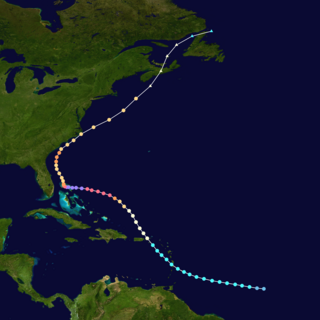
Hurricane Dorian was the strongest hurricane to affect The Bahamas on record, causing catastrophic damage on the islands of Abaco Islands and Grand Bahama, in early September 2019. The cyclone's intensity, as well as its slow forward motion near The Bahamas, broke numerous records. The fifth tropical cyclone, fourth named storm, second hurricane, and first major hurricane of the 2019 Atlantic hurricane season, Dorian originated from a westward-traveling tropical wave, that departed from the western coast of Africa on August 19. The system organized into a tropical depression and later a tropical storm, both on August 24.
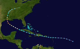
Hurricane Laura tied the record for the strongest hurricane to make landfall in Louisiana as measured by maximum sustained winds, along with the 1856 Last Island hurricane and Hurricane Ida, and was overall the tenth-strongest hurricane to make landfall in the United States. The thirteenth tropical cyclone, twelfth named storm, fourth hurricane, and first major hurricane of the 2020 Atlantic hurricane season, Laura originated from a large tropical wave that moved off the West African coast on August 16. The tropical wave gradually organized, becoming a tropical depression on August 20. Though in only a marginally conducive environment for intensification, the depression nevertheless intensified into a tropical storm a day later, becoming the earliest twelfth named storm on record in the North Atlantic basin, forming eight days earlier than 1995's Hurricane Luis. The depression received the name Laura and tracked west-northwest towards the Lesser Antilles.

Hurricane Iota was the second-most powerful November tropical cyclone on record in the Atlantic basin, behind only the 1932 Cuba hurricane. It was also the strongest and most intense hurricane of the hyperactive 2020 Atlantic hurricane season. At the end of October, a tropical wave emerged off Africa and traversed the Atlantic Ocean with little note. The system later impacted northern South America and the Lesser Antilles before becoming more organized, eventually becoming a tropical depression on November 13 over the Caribbean Sea. Initially stymied by adverse environmental conditions the system, which soon became Tropical Storm Iota, struggled to organize as it took an atypical southwest track. After developing a small, well-organized core, Iota entered region exceptionally favorable for explosive intensification and dramatically developed. Within a 42-hour period from November 15 to 16, Iota strengthened from a tropical storm to a high-end Category 4 hurricane with peak winds of 155 mph (249 km/h). The hurricane's eyewall impacted the Colombian islands of Providencia and Santa Catalina around this time. Moving along a westward course, Iota slowly weakened and eventually made landfall in Nicaragua with winds of 145 mph (233 km/h) in nearly the same location as Hurricane Eta two weeks prior. Once inland, interaction with the region's mountainous terrain caused the system to rapidly deteriorate and its surface circulation dissipated on November 18. Its remnants persisted another day before last being noted southwest of Guatemala.

Hurricane Sam was a powerful and long-lived Cape Verde hurricane that threatened Bermuda, lasting from late September through early October. It was the fifth longest-lasting intense Atlantic hurricane, as measured by accumulated cyclone energy, since reliable records began in 1966. The eighteenth named storm, seventh hurricane, and fourth major hurricane of the 2021 Atlantic hurricane season, Sam originated from a tropical wave that departed from the western coast of Africa on September 19. The system developed into a tropical depression on September 22, as upper-level winds gradually became more favorable. Intensification was initially slow, with the depression strengthening into Tropical Storm Sam a day later. Soon afterward, the structure of the cyclone quickly improved and rapid intensification began. Sam strengthened into a hurricane on September 24, and reached Category 4 status late on September 25. Sam peaked on September 26 as a high-end Category 4 hurricane, with maximum sustained winds of 155 mph (249 km/h) and a minimum central pressure of 927 mbar (27.4 inHg). The storm turned towards the northwest early on September 27, as it began to weaken due to an eyewall replacement cycle. The hurricane weakened to Category 3 intensity later that day, as its structure decayed. Sam regained Category 4 status early on September 28. Another eyewall replacement cycle on September 29 disrupted the storm once more.

Hurricane Fiona was a large, powerful, and destructive Category 4 Atlantic hurricane which was the costliest and most intense tropical or post-tropical cyclone to hit Canada on record. It was the sixth named storm, third hurricane and first major hurricane of the 2022 Atlantic hurricane season.


