Meteorological instrumentation

Last updated
Galileo thermometer Galileo Thermometer closeup.jpg
Galileo thermometer

Meteorological instruments (or weather instruments), including meteorological sensors (weather sensors), are the equipment used to find the state of the atmosphere at a given time. Each science has its own unique sets of laboratory equipment. Meteorology, however, is a science which does not use much laboratory equipment but relies more on on-site observation and remote sensing equipment. In science, an observation, or observable, is an abstract idea that can be measured and for which data can be taken. Rain was one of the first quantities to be measured historically. Two other accurately measured weather-related variables are wind and humidity. Many attempts had been made prior to the 15th century to construct adequate equipment to measure atmospheric variables.

Contents

History

Devices used to measure weather phenomena in the mid-20th century were the rain gauge, the anemometer, and the hygrometer. The 17th century saw the development of the barometer and the Galileo thermometer while the 18th century saw the development of the thermometer with the Fahrenheit and Celsius scales. The 20th century developed new remote sensing tools, such as weather radars, weather satellites and wind profilers, which provide better sampling both regionally and globally. Remote sensing instruments collect data from weather events some distance from the instrument and typically stores the data where the instrument is located and often transmits the data at defined intervals to central data centers.

In 1441, King Sejong's son, Prince Munjong, invented the first standardized rain gauge. These were sent throughout the Joseon Dynasty of South Korea as an official tool to assess land taxes based upon a farmer's potential harvest. In 1450, Leone Battista Alberti developed a swinging-plate anemometer, and is known as the first anemometer. [1] In 1607, Galileo Galilei constructs a thermoscope. In 1643, Evangelista Torricelli invents the mercury barometer. [1] In 1662, Sir Christopher Wren invented the mechanical, self-emptying, tipping bucket rain gauge. In 1714, Gabriel Fahrenheit creates a reliable scale for measuring temperature with a mercury-type thermometer. [2] In 1742, Anders Celsius, a Swedish astronomer, proposed the 'centigrade' temperature scale, the predecessor of the current Celsius scale. [3] In 1783, the first hair hygrometer is demonstrated by Horace-Bénédict de Saussure. In 1806, Francis Beaufort introduced his system for classifying wind speeds. [4] The April 1960 launch of the first successful weather satellite, TIROS-1, marked the beginning of the age where weather information became available globally.

This was also used to measure the temperature of the surrounding air.

Types

Modern 2020 aneroid barometer Modern Aneroid Barometer.jpg
Modern 2020 aneroid barometer

A thermometer measures air temperature, or the kinetic energy of the molecules within air. A barometer measures atmospheric pressure, or the pressure exerted by the weight of the Earth's atmosphere above a particular location. An anemometer measures the wind speed and the direction the wind is blowing from at the site where it is mounted. A hygrometer measures the relative humidity at a location, which can then be used to compute the dew point. Radiosondes directly measure most of these quantities, except for wind, which is determined by tracking the radiosonde signal with an antenna or theodolite. Supplementing the radiosondes a network of aircraft collection is organized by the World Meteorological Organization (WMO), which also use these instruments to report weather conditions at their respective locations. A sounding rocket or rocketsonde, sometimes called a research rocket, is an instrument-carrying rocket designed to take measurements and perform scientific experiments during its suborbital flight.

A pyranometer is a type of actinometer used to measure broadband solar irradiance on a planar surface and is a sensor that is designed to measure the solar radiation flux density (in watts per metre square) from a field of view of 180 degrees. A ceilometer is a device that uses a laser or other light source to determine the height of a cloud base. Ceilometers can also be used to measure the aerosol concentration within the atmosphere. A ceiling balloon is used by meteorologists to determine the height of the base of clouds above ground level during daylight hours. The principle behind the ceiling balloon is a balloon with a known ascent rate (how fast it climbs) and determining how long the balloon rises until it disappears into the cloud. Ascent rate times ascent time yields the ceiling height. A disdrometer is an instrument used to measure the drop size distribution and velocity of falling hydrometeors. Rain gauges are used to measure the precipitation which falls at any point on the Earth's landmass.

Remote sensing, as used in meteorology, is the concept of collecting data from remote weather events and subsequently producing weather information. Each remote sensing instrument collects data about the atmosphere from a remote location and, usually, stores the data where the instrument is located. The most common types of remote sensing are radar, lidar, and satellites (also photogrammetry). The main uses of radar are to collect information concerning the coverage and characteristics of precipitation and wind. Satellites are chiefly used to determine cloud cover, as well as wind. SODAR (SOnic Detection And Ranging) is a meteorological instrument as one form of wind profiler, which measures the scattering of sound waves by atmospheric turbulence. Sodar systems are used to measure wind speed at various heights above the ground, and the thermodynamic structure of the lower layer of the atmosphere. Radar and lidar are not passive because both use electromagnetic radiation to illuminate a specific portion of the atmosphere. [5] Weather satellites along with more general-purpose Earth-observing satellites circling the earth at various altitudes have become an indispensable tool for studying a wide range of phenomena from forest fires to El Niño.

Weather stations

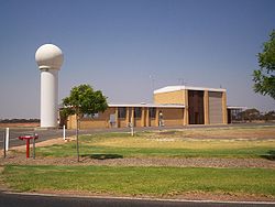
A weather station is a facility with instruments and equipment to make observations of atmospheric conditions in order to provide information to make weather forecasts and to study the weather and climate. The measurements taken include temperature, barometric pressure, humidity, wind speed, wind direction, and precipitation amounts. Wind measurements are taken as free of other obstructions as possible, while temperature and humidity measurements are kept free from direct solar radiation, or insolation. Manual observations are taken at least once daily, while automated observations are taken at least once an hour.

Surface weather observations

Weather station at Mildura Airport, Victoria, Australia. Mildura Airport Weatherstation.jpg
Weather station at Mildura Airport, Victoria, Australia.

Surface weather observations are the fundamental data used for safety as well as climatological reasons to forecast weather and issue warnings worldwide. [6] They can be taken manually, by a weather observer, by computer through the use of automated weather stations, or in a hybrid scheme using weather observers to augment the otherwise automated weather station. The ICAO defines the International Standard Atmosphere, which is the model of the standard variation of pressure, temperature, density, and viscosity with altitude in the Earth's atmosphere, and is used to reduce a station pressure to sea level pressure. Airport observations can be transmitted worldwide through the use of the METAR observing code. Personal weather stations taking automated observations can transmit their data to the United States mesonet through the use of the Citizen Weather Observer Program (CWOP), or internationally through the Weather Underground Internet site. [7] A thirty-year average of a location's weather observations is traditionally used to determine the station's climate. [8]

See also

Related Research Articles

<span class="mw-page-title-main">Meteorology</span> Interdisciplinary scientific study of the atmosphere focusing on weather forecasting

Meteorology is a branch of the atmospheric sciences with a major focus on weather forecasting. The study of meteorology dates back millennia, though significant progress in meteorology did not begin until the 18th century. The 19th century saw modest progress in the field after weather observation networks were formed across broad regions. Prior attempts at prediction of weather depended on historical data. It was not until after the elucidation of the laws of physics, and more particularly in the latter half of the 20th century, the development of the computer that significant breakthroughs in weather forecasting were achieved. An important branch of weather forecasting is marine weather forecasting as it relates to maritime and coastal safety, in which weather effects also include atmospheric interactions with large bodies of water.

<span class="mw-page-title-main">Weather balloon</span> High-altitude balloon to which meteorological instruments are attached

A weather balloon, also known as sounding balloon, is a balloon that carries instruments aloft to send back information on atmospheric pressure, temperature, humidity and wind speed by means of a small, expendable measuring device called a radiosonde. To obtain wind data, they can be tracked by radar, radio direction finding, or navigation systems. Balloons meant to stay at a constant altitude for long periods of time are known as transosondes. Weather balloons that do not carry an instrument pack are used to determine upper-level winds and the height of cloud layers. For such balloons, a theodolite or total station is used to track the balloon's azimuth and elevation, which are then converted to estimated wind speed and direction and/or cloud height, as applicable.

<span class="mw-page-title-main">Radiosonde</span> Meteorological instrumentation

A radiosonde is a battery-powered telemetry instrument carried into the atmosphere usually by a weather balloon that measures various atmospheric parameters and transmits them by radio to a ground receiver. Modern radiosondes measure or calculate the following variables: altitude, pressure, temperature, relative humidity, wind, cosmic ray readings at high altitude and geographical position (latitude/longitude). Radiosondes measuring ozone concentration are known as ozonesondes.

<span class="mw-page-title-main">Weather station</span> Facility for atmospheric research and prediction

A weather station is a facility, either on land or sea, with instruments and equipment for measuring atmospheric conditions to provide information for weather forecasts and to study the weather and climate. The measurements taken include temperature, atmospheric pressure, humidity, wind speed, wind direction, and precipitation amounts. Wind measurements are taken with as few other obstructions as possible, while temperature and humidity measurements are kept free from direct solar radiation, or insolation. Manual observations are taken at least once daily, while automated measurements are taken at least once an hour. Weather conditions out at sea are taken by ships and buoys, which measure slightly different meteorological quantities such as sea surface temperature (SST), wave height, and wave period. Drifting weather buoys outnumber their moored versions by a significant amount.

The timeline of meteorology contains events of scientific and technological advancements in the area of atmospheric sciences. The most notable advancements in observational meteorology, weather forecasting, climatology, atmospheric chemistry, and atmospheric physics are listed chronologically. Some historical weather events are included that mark time periods where advancements were made, or even that sparked policy change.

<span class="mw-page-title-main">Hygrometer</span> Instrument for measuring humidity

A hygrometer is an instrument which measures the humidity of air or some other gas: that is, how much water vapor it contains. Humidity measurement instruments usually rely on measurements of some other quantities such as temperature, pressure, mass and mechanical or electrical changes in a substance as moisture is absorbed. By calibration and calculation, these measured quantities can lead to a measurement of humidity. Modern electronic devices use the temperature of condensation, or they sense changes in electrical capacitance or resistance to measure humidity differences. A crude hygrometer was invented by Leonardo da Vinci in 1480. Major leaps came forward during the 1600s; Francesco Folli invented a more practical version of the device, while Robert Hooke improved a number of meteorological devices including the hygrometer. A more modern version was created by Swiss polymath Johann Heinrich Lambert in 1755. Later, in the year 1783, Swiss physicist and Geologist Horace Bénédict de Saussure invented the first hygrometer using human hair to measure humidity.

<span class="mw-page-title-main">Dropsonde</span>

A dropsonde is an expendable weather reconnaissance device created by the National Center for Atmospheric Research (NCAR), designed to be dropped from an aircraft at altitude over water to measure storm conditions as the device falls to the surface. The sonde contains a GPS receiver, along with pressure, temperature, and humidity (PTH) sensors to capture atmospheric profiles and thermodynamic data. It typically relays this data to a computer in the aircraft by radio transmission.

<span class="mw-page-title-main">Vaisala</span> Finnish technology company making measuring instruments

Vaisala Oyj is a Finnish company that produces products and services for environmental and industrial measurement.

<span class="mw-page-title-main">Automatic weather station</span> Meteorological instrument

An automatic weather station (AWS) is an automated version of the traditional weather station, either to save human labor or to enable measurements from remote areas. An AWS will typically consist of a weather-proof enclosure containing the data logger, rechargeable battery, telemetry (optional) and the meteorological sensors with an attached solar panel or wind turbine and mounted upon a mast. The specific configuration may vary due to the purpose of the system. The system may report in near real time via the Argos System, LoRa and the Global Telecommunications System, or save the data for later recovery.

<span class="mw-page-title-main">Index of meteorology articles</span>

This is a list of meteorology topics. The terms relate to meteorology, the interdisciplinary scientific study of the atmosphere that focuses on weather processes and forecasting.

The National Severe Storms Laboratory (NSSL) is a National Oceanic and Atmospheric Administration (NOAA) weather research laboratory under the Office of Oceanic and Atmospheric Research. It is one of seven NOAA Research Laboratories (RLs).

<span class="mw-page-title-main">Freezing level</span> Altitude in which the temperature is at 0 °C

The freezing level, or 0 °C (zero-degree) isotherm, represents the altitude in which the temperature is at 0 °C in a free atmosphere. Any given measure is valid for only a short period of time, often less than a day as variations in wind, sunlight, air masses and other factors may change the level.

Atmospheric sounding or atmospheric profiling is a measurement of vertical distribution of physical properties of the atmospheric column such as pressure, temperature, wind speed and wind direction, liquid water content, ozone concentration, pollution, and other properties. Such measurements are performed in a variety of ways including remote sensing and in situ observations.

<span class="mw-page-title-main">Outline of meteorology</span> Overview of and topical guide to meteorology

The following outline is provided as an overview of and topical guide to the field of Meteorology.

<span class="mw-page-title-main">Surface weather observation</span> Fundamental data used for weather forecasts

Surface weather observations are the fundamental data used for safety as well as climatological reasons to forecast weather and issue warnings worldwide. They can be taken manually, by a weather observer, by computer through the use of automated weather stations, or in a hybrid scheme using weather observers to augment the otherwise automated weather station. The ICAO defines the International Standard Atmosphere (ISA), which is the model of the standard variation of pressure, temperature, density, and viscosity with altitude in the Earth's atmosphere, and is used to reduce a station pressure to sea level pressure. Airport observations can be transmitted worldwide through the use of the METAR observing code. Personal weather stations taking automated observations can transmit their data to the United States mesonet through the Citizen Weather Observer Program (CWOP), the UK Met Office through their Weather Observations Website (WOW), or internationally through the Weather Underground Internet site. A thirty-year average of a location's weather observations is traditionally used to determine the station's climate. In the US a network of Cooperative Observers make a daily record of summary weather and sometimes water level information.

<span class="mw-page-title-main">Rover Environmental Monitoring Station</span>

Rover Environmental Monitoring Station (REMS) is a weather station on Mars for Curiosity rover contributed by Spain and Finland. REMS measures humidity, pressure, temperature, wind speeds, and ultraviolet radiation on Mars. This Spanish project is led by the Spanish Astrobiology Center and includes the Finnish Meteorological Institute as a partner, contributing pressure and humidity sensors.

Ground-based, flight-based, or satellite-based remote sensing instruments can be used to measure properties of the planetary boundary layer, including boundary layer height, aerosols and clouds. Satellite remote sensing of the atmosphere has the advantage of being able to provide global coverage of atmospheric planetary boundary layer properties while simultaneously providing relatively high temporal sampling rates. Advancements in satellite remote sensing have provided greater vertical resolution which enables higher accuracy for planetary boundary layer measurements.

<span class="mw-page-title-main">Glossary of meteorology</span> List of definitions of terms and concepts commonly used in meteorology

This glossary of meteorology is a list of terms and concepts relevant to meteorology and atmospheric science, their sub-disciplines, and related fields.

Atmospheric correction for Interferometric Synthetic ApertureRadar (InSAR) technique is a set of different methods to remove artefact displacement from an interferogram caused by the effect of weather variables such as humidity, temperature, and pressure. An interferogram is generated by processing two synthetic-aperture radar images before and after a geophysical event like an earthquake. Corrections for atmospheric variations are an important stage of InSAR data processing in many study areas to measure surface displacement because relative humidity differences of 20% can cause inaccuracies of 10–14 cm InSAR due to varying delays in the radar signal. Overall, atmospheric correction methods can be divided into two categories: a) Using Atmospheric Phase Screen (APS) statistical properties and b) Using auxiliary (external) data such as GPS measurements, multi-spectral observations, local meteorological models, and global atmospheric models.

References

  1. 1 2 Jacobson, Mark Z. (June 2005). Fundamentals of Atmospheric Modeling (paperback) (2nd ed.). New York: Cambridge University Press. p. 828. ISBN   978-0-521-54865-6.
  2. Grigull, U., Fahrenheit, a Pioneer of Exact Thermometry. Heat Transfer, 1966, The Proceedings of the 8th International Heat Transfer Conference, San Francisco, 1966, Vol. 1.
  3. Beckman, Olof, History of the Celsius temperature scale., translated, Anders Celsius (Elementa,84:4,2001); English
  4. Bill Giles O.B.E. (2009). Beaufort Scale. BBC. Retrieved on 2009-05-12.
  5. Peebles, Peyton, [1998], Radar Principles, John Wiley & Sons, Inc., New York, ISBN   0-471-25205-0.
  6. Office of the Federal Coordinator of Meteorology. Surface Weather Observation Program. Archived 2009-05-06 at the Wayback Machine Retrieved on 2008-01-12.
  7. Weather Underground. Personal Weather Station. Retrieved on 2008-03-09.
  8. Met Office. Climate Averages. Archived 2009-07-06 at the Wayback Machine Retrieved on 2008-03-09.