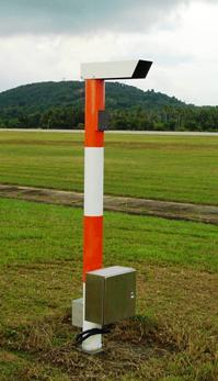
Present weather sensor

Last updated
ASOS present weather sensor 2008-07-09 Ely Airport ASOS Present Weather Sensor in Ely, Nevada.jpg
ASOS present weather sensor

The present weather sensor (PWS) is a component of an automatic weather station that detects the presence of hydrometeors and determines their type (rain, snow, drizzle, etc.) and intensity. It works on a principle similar to a bistatic radar, noting the passage of droplets, or flakes, between a transmitter and a sensor. These instruments in automatic weather stations are used to simulate the observation taken by a human observer. They allow rapid reporting of any change in the type and intensity of precipitation, but include interpretation limitations.

Contents

Principle

Types

There are at least two types of devices used to detect precipitation:

Data processing

With the speed of fall and the size of the particles, it is then possible to determine the type of precipitation (rain falls much faster than snowflakes for example) with a contingency table. The detector will report the type of precipitation with the largest population in the samples. [2] However, in some cases, the characteristics of two types of precipitation may be similar (drizzle and snow fall at speeds very close to each other), or there may be a mixture of precipitation (e.g. rain and melting snow).

To refine detection in the event of ambiguity, these devices use the dew point temperature (or, if missing, environmental temperature) and the icing detector output. Thus, if the detector identifies the falling speed for the dual snow/drizzle at an ambient dew point greater than 1 °C (34 °F) it will classify it as drizzle, and below −1 °C (30 °F), it will be snow. [2] The icing detector will also be used to determine if rain or drizzle is freezing when the temperature is below freezing.

When these additional data still do not make it possible to differentiate (e.g. if the dew point of the previous example is between −1 and 1 °C), the type is then reported as "unknown". Thus at the moment, these devices cannot report hail, ice pellets, and various other intermediate forms of precipitation. [1] [2]

The instantaneous intensity of precipitation is calculated by the intensity of the scintillation (LED sensor) or the reflectivity (POSS). It is reported as very weak, weak, moderate or strong. [1] [2]

Frequency of reporting

Automatic stations report on a regular schedule depending on their use, most reporting hourly. However, they will issue a special report if one or more of their sensors detects a significant change in weather conditions. Such specials are issued when precipitation of at least low intensity starts or stops, or the type of precipitation changes.

The present weather sensor takes samples every minute and the automatic station processing system stores them for 15 minutes. A special will be broadcast when at least three precipitation detections are made in 15 minutes for the start, if at least 12 minutes pass without precipitation, or if the intensity variation corresponds to a significant change.

Limitations

The detail of mixed precipitation is not generally possible as the sensor is giving only the dominant one. The report is only valid at the sensor position, it will thus miss precipitation further afield that can be significative. Finally, it cannot by itself distinguish showers from continuous rain/snow.

False observations of precipitation are generally due to: [1] [2]

Enhancements

Thundershowers and continuous precipitation can be separated by using a lightning detector with the sensor result. Ground-based and mobile detectors obtain the direction and severity of lightning.

Scatterometers and transmissometers, where the extinction of a visual signal through air from a source to a receiver is noted, will give the horizontal visibility. In case there is no precipitation reported by the PWS, this will be revert the conclusion to fog or haze.

Related Research Articles

Rain gauge

A rain gauge is an instrument used by meteorologists and hydrologists to gather and measure the amount of liquid precipitation over an area in a predefined period of time.

Millimeter cloud radar

Millimeter-wave cloud radars, also denominated cloud radars, are radar systems designed to monitor clouds with operating frequencies between 24 and 110 GHz. Accordingly, their wavelengths range from 1 mm to 1.11 cm, about ten times shorter than those used in conventional S band radars such as NEXRAD.

Freezing rain rain maintained at temperatures below freezing

Freezing rain is the name given to rain maintained at temperatures below freezing by the ambient air mass that causes freezing on contact with surfaces. Unlike a mixture of rain and snow, ice pellets, or hail, freezing rain is made entirely of liquid droplets. The raindrops become supercooled while passing through a sub-freezing layer of air hundreds of meters above the ground, and then freeze upon impact with any surface they encounter, including the ground, trees, electrical wires, aircraft, and automobiles. The resulting ice, called glaze ice, can accumulate to a thickness of several centimeters and cover all exposed surfaces. The METAR code for freezing rain is FZRA.

Precipitation Product of the condensation of atmospheric water vapor that falls under gravity

In meteorology, precipitation is any product of the condensation of atmospheric water vapor that falls under gravity from clouds. The main forms of precipitation include drizzle, rain, sleet, snow, ice pellets, graupel and hail. Precipitation occurs when a portion of the atmosphere becomes saturated with water vapor, so that the water condenses and "precipitates" or falls. Thus, fog and mist are not precipitation but colloids, because the water vapor does not condense sufficiently to precipitate. Two processes, possibly acting together, can lead to air becoming saturated: cooling the air or adding water vapor to the air. Precipitation forms as smaller droplets coalesce via collision with other rain drops or ice crystals within a cloud. Short, intense periods of rain in scattered locations are called "showers."

Weather radar

Weather radar, also called weather surveillance radar (WSR) and Doppler weather radar, is a type of radar used to locate precipitation, calculate its motion, and estimate its type. Modern weather radars are mostly pulse-Doppler radars, capable of detecting the motion of rain droplets in addition to the intensity of the precipitation. Both types of data can be analyzed to determine the structure of storms and their potential to cause severe weather.

Backscatter

In physics, backscatter is the reflection of waves, particles, or signals back to the direction from which they came. It is usually a diffuse reflection due to scattering, as opposed to specular reflection as from a mirror, although specular backscattering can occur at normal incidence with a surface. Backscattering has important applications in astronomy, photography, and medical ultrasonography. The opposite effect is forward scatter, e.g. when a translucent material like a cloud diffuses sunlight, giving soft light.

Rain sensor

A rain sensor or rain switch is a switching device activated by rainfall. There are two main applications for rain sensors. The first is a water conservation device connected to an automatic irrigation system that causes the system to shut down in the event of rainfall.

PWS may refer to:

Security alarm A system that detects unauthorised entry

A security alarm is a system designed to detect intrusion – unauthorized entry – into a building or other area such as a home or school. Security alarms are used in residential, commercial, industrial, and military properties for protection against burglary (theft) or property damage, as well as personal protection against intruders. Security alarms in residential areas show a correlation with decreased theft. Car alarms likewise help protect vehicles and their contents. Prisons also use security systems for control of inmates.

Index of meteorology articles Wikipedia index

This is a list of meteorology topics. The terms relate to meteorology, the interdisciplinary scientific study of the atmosphere that focuses on weather processes and forecasting.

The National Severe Storms Laboratory (NSSL) is a National Oceanic and Atmospheric Administration (NOAA) weather research laboratory under the Office of Oceanic and Atmospheric Research. It is one of seven NOAA Research Laboratories (RLs).

dBZ (meteorology) Unit of measure used in weather radar.

dBZ stands for decibel relative to Z. It is a logarithmic dimensionless technical unit used in radar, mostly in weather radar, to compare the equivalent reflectivity factor (Z) of a remote object to the return of a droplet of rain with a diameter of 1 mm. It is proportional to the number of drops per unit volume and the sixth power of drops' diameter and is thus used to estimate the rain or snow intensity. With other variables analyzed from the radar returns it helps to determine the type of precipitation. Both the radar reflectivity factor and its logarithmic version are commonly referred to as reflectivity when the context is clear. In short, the higher the dBZ value, the more likely it is for severe weather to occur in the form of precipitation.

The J.S. Marshall Radar Observatory is a McGill University facility in Sainte-Anne-de-Bellevue, Quebec, Canada housing several weather radars and other meteorological sensors, many of them running around the clock. It is one of the components of the McGill Atmospheric and Oceanic Sciences department where students in remote sensing perform their research. Furthermore, the main radar is part of the Canadian weather radar network, was on a contract with the Meteorological Service of Canada, as well as a research device, up to October 3, 2018.

Lightning detection

A lightning detector is a device that detects lightning produced by thunderstorms. There are three primary types of detectors: ground-based systems using multiple antennas, mobile systems using a direction and a sense antenna in the same location, and space-based systems.

Precipitation types

In meteorology, the various types of precipitation often include the character or phase of the precipitation which is falling to ground level. There are three distinct ways that precipitation can occur. Convective precipitation is generally more intense, and of shorter duration, than stratiform precipitation. Orographic precipitation occurs when moist air is forced upwards over rising terrain, such as a mountain.

Convective storm detection is the meteorological observation, and short-term prediction, of deep moist convection (DMC). DMC describes atmospheric conditions producing single or clusters of large vertical extension clouds ranging from cumulus congestus to cumulonimbus, the latter producing thunderstorms associated with lightning and thunder. Those two types of clouds can produce severe weather at the surface and aloft.

Automated airport weather station Automated sensor suites

Airport weather stations are automated sensor suites which are designed to serve aviation and meteorological operations, weather forecasting and climatology. Automated airport weather stations have become part of the backbone of weather observing in the United States and Canada and are becoming increasingly more prevalent worldwide due to their efficiency and cost-savings.

Outline of meteorology Overview of and topical guide to meteorology

The following outline is provided as an overview of and topical guide to the field of Meteorology.

Glossary of meteorology List of definitions of terms and concepts commonly used in meteorology

This glossary of meteorology is a list of terms and concepts relevant to meteorology and atmospheric science, their sub-disciplines, and related fields.

References

  1. 1 2 3 4 Wade, Charles G. (June 2003). "A Multisensor Approach to Detecting Drizzle on ASOS". Journal of Atmospheric and Oceanic Technology. American Meteorological Society. 20 (6): 820. Bibcode:2003JAtOT..20..820W. doi: 10.1175/1520-0426(2003)020<0820:AMATDD>2.0.CO;2 . Retrieved March 23, 2020.
  2. 1 2 3 4 5 6 "Precipitation - Occurance[sic];". Automated Weather Observation System - AWOS. Meteorological Service of Canada. Archived from the original on May 10, 2006. Retrieved March 23, 2020.