Miami City Hall

Last updated
Pan American Seaplane Base and Terminal Building
Miami FL Pan Am Bldg city hall03.jpg
Miami City Hall, former Pan American Terminal Building, in 2011
Location map Miami.png
Red pog.svg
USA Florida location map.svg
Red pog.svg
Usa edcp location map.svg
Red pog.svg
Location3500 Pan American Dr., Miami, Florida
Coordinates 25°43′40″N80°14′02″W / 25.72773°N 80.2338°W / 25.72773; -80.2338 Coordinates: 25°43′40″N80°14′02″W / 25.72773°N 80.2338°W / 25.72773; -80.2338
Area10 acres (4.0 ha)
Built1934 (1934)
NRHP reference No. 75000548 [1]
Added to NRHPFebruary 20, 1975
Miami City Hall Miami FL Pan Am Bldg city hall04.jpg
Miami City Hall
Miami City Hall Miami city hall.jpg
Miami City Hall

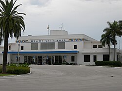
Miami City Hall is the local government headquarters for the City of Miami, Florida. It has been located in the former Pan American Airlines Terminal Building on Dinner Key, which was designed by Delano & Aldrich and constructed in 1934 [2] for the former International Pan American Airport, [3] since 1954. [4] The city's government headquarters originated in Downtown Miami for 58 years until its relocation to Coconut Grove.

Contents

History

An early city hall located in downtown on Flagler Street (formerly "Twelfth Street") just southeast of the Florida East Coast Railroad Miami depot and designed by Walter De Garmo was in use from 1907 until 1928. [5] Miami's city hall was then relocated one block north, and housed in the newly constructed Dade County Courthouse from 1928 until it was moved to its current Coconut Grove location in 1954. [6]

The terminal building was added to the U.S. National Register of Historic Places on February 20, 1975. [7]

Pan Am's final flight to Dinner Key took place August 9, 1945 as seaplane use decreased with the construction of landing fields (airports) in Latin America. [3]

See also

Related Research Articles

Miami City in Florida, United States

Miami, officially the City of Miami, is a coastal metropolis located in Miami-Dade County in southeastern Florida, in the United States. With a population of 442,241 as of the 2020 census, it is the second-most populous city in Florida, the eleventh-most populous city in the Southeast U.S., and the 44th most populous city in the nation. Miami is the core of the nation's ninth largest and world's 34th largest metropolitan area with a population of 6.138 million people as of 2020. The city has the third largest skyline in the United States with over 300 high-rises, 58 of which exceed 491 ft (150 m).

Coconut Grove Neighborhood of Miami, Florida, United States

Coconut Grove, also known colloquially as The Grove, is the oldest continuously inhabited neighborhood of Miami in Miami-Dade County, Florida, United States. The neighborhood is roughly bound by North Prospect Drive to the south, LeJeune Road to the west, South Dixie Highway and Rickenbacker Causeway to the north, and Biscayne Bay to the east. It is south of the neighborhoods of Brickell and The Roads and east of Coral Gables. The neighborhood's name has been sometimes spelled "Cocoanut Grove" but the definitive spelling "Coconut Grove" was established when the city was incorporated in 1919.

Government Center station (Miami) Miami-Dade Transit metro station

Government Center station is an intermodal transit hub in the Government Center district of Downtown Miami, Florida. It is operated by Miami-Dade Transit and serves as a transfer station for the Metrorail and Metromover rapid transit systems and as a bus station for Metrobus, Paratransit, and Broward County Transit buses. The station is located near the intersection of Northwest First Street and First Avenue, a part of the Stephen P. Clark Government Center Building. It opened to service May 20, 1984, next to the site of a former FEC railway station which is now MiamiCentral.

Dinner Key is a marina complex in the Coconut Grove neighborhood of Miami, Florida, along the shore of Biscayne Bay on South Bayshore Drive. It was originally an island, but was connected to the mainland in 1914 by filling in the intervening space. An early source attributes the name to the island being a convenient place to stop to eat while traveling by boat between the mouth of the Miami River and Snapper Creek south of Miami. Dinner Key is accessible by public transit via the Coconut Grove Circulator from the Miami Metrorail at Coconut Grove and Douglas Road stations. Formerly, it has been the location of Coast Guard Air Station Dinner Key and International Pan American Airport.

Overtown (Miami) Neighborhood of Miami in Miami-Dade County, Florida, United States

Overtown is a neighborhood of Miami, Florida, United States, just northwest of Downtown Miami. Originally called Colored Town during the Jim Crow era of the late 19th through the mid-20th century, the area was once the preeminent and is the historic center for commerce in the black community in Miami and South Florida.

Downtown Miami Historic District United States historic place

The Downtown Miami Historic District is a U.S. historic district located in the Central Business District of Downtown Miami, Florida.

Greater Downtown Miami Neighborhood of Miami in Miami-Dade County, Florida, United States

Downtown Miami is the urban city center of Miami, Florida, in the United States. The city's greater downtown region consists of the Central Business District, Brickell, the Historic District, Government Center, the Arts & Entertainment District, and Park West. It is divided by the Miami River and is bordered by Midtown Miami's Edgewater and Wynwood sections to its north, Biscayne Bay to its east, the Health District and Overtown to its west, and Coconut Grove to its south.

Miami Avenue

Miami Avenue is a 16.8-mile (27.0 km) main north–south street running through Coconut Grove, Brickell, Downtown, and Midtown in Miami, Florida. It is the meridian road dividing the street grid of Miami and Miami-Dade County into east and west avenues.

Miami-Dade County Courthouse United States historic place

The Miami-Dade County Courthouse, formerly known as the Dade County Courthouse, is a historic courthouse and skyscraper located at 73 West Flagler Street in Miami, Florida. Constructed over four years (1925–28), it was added to the U.S. National Register of Historic Places on January 4, 1989. The building is 361 feet tall with 28 floors. When it was built, it was the tallest building in Miami and in Florida.

First Coconut Grove Schoolhouse United States historic place

The First Coconut Grove Schoolhouse is a historic school located within City of Miami limits, in Dade County, Florida. The school originally resided at 2916 Grand Avenue, Miami, Florida, 33133. The structure was built in 1887, by Coconut Grove pioneer, Charles Peacock. Peacock reportedly constructed the house using wood gathered from ships wrecked in nearby Key Biscayne. The building originally served as a community gathering place, with Sunday School as its main purpose.

Trapp Homestead Historic house in Florida, United States

The Trapp Homestead is a historic home in the Coconut Grove section of the City of Miami, Florida, United States. It is located at 2521 South Bayshore Drive. On November 10, 1994, it was added to the U.S. National Register of Historic Places. The home was constructed in 1887 out of oolitic lime quarried locally by Caleb Trapp and his son, Harlan. During construction, the Trapps lived on a thatched hut at the front of the property. The property is believed to be the oldest-standing masonry home in Miami-Dade County, Florida. The estate's construction pre-dates the incorporation of the City of Miami. The estate was particularly notable at the time because it was one of the few stone structures in Miami-Dade County, as nearly all structures in the area were built of wood at that time.

August Geiger (architect) American architect

August Geiger was one of the most prominent American architects in South Florida from 1905 to the late 1940s. He experimented in Mission, Neo-Renaissance and Art Deco architecture, but is most noted for his works in the Mediterranean Revival style. A number of his works are listed on the U.S. National Register of Historic Places.

Womans Club of Coconut Grove United States historic place

The Woman's Club of Coconut Grove is a historic woman's club in Miami, Florida.

Kiehnel and Elliott American architect

The architectural firm of Kiehnel and Elliot was established in Pittsburgh, Pennsylvania, in 1906. The firm did substantial work in Florida, and moved to Miami in 1922. From 1926, it was known as Kiehnel, Elliot and Chalfant.

Government Center (Miami) Neighborhood in Miami, Florida

Government Center is a district in the western portion of downtown Miami, Florida bound roughly by I-95 and West (NW/SW) 3rd Avenue to the west, South (SW/SE) 1st Street to the south, North (NE/NW) 5th Street to the north, and East (NE/SE) 1st Avenue to the east.

The following is a timeline of the history of the city of Miami in Miami-Dade County, Florida, United States.

Walter De Garmo American architect

Walter C. De Garmo (1876–1951) was a prominent architect in Miami, Florida and its surrounding communities. His buildings include the Woman's Club of Coconut Grove and the 1907 Miami City Hall. He is known for his residential work in South Florida, especially large luxury residences in the Mission Revival and Mediterranean Revival styles.

Coast Guard Air Station Dinner Key United States historic place

Coast Guard Air Station Dinner Key is a former United States Coast Guard facility located in Dinner Key, Miami, Florida. It was built next to the International Pan American Airport.

International Pan American Airport

International Pan American Airport is a former airport in Dinner Key, Miami, Florida operated by Pan American World Airways from 1932 to 1945. During its existence, it operated alongside Coast Guard Air Station Dinner Key.

Central Business District (Miami) Central business district in the United States

Central Business District (CBD) is the historic city center of what has become Greater Downtown Miami, in Miami, Florida, United States. Over 92,000 people work in the Central Business District.

References

  1. "National Register Information System". National Register of Historic Places . National Park Service. July 9, 2010.
  2. Writers' Program (Fla.) (1941). Planning Your Vacation in Florida: Miami and Dade County, including Miami Beach and Coral Gables. Northport, N.Y.: Bacon, Percy & Daggett; reprint, New York: AMS Press, 1983. p. 135. ISBN   0404579078.
  3. 1 2 "Pan American Seaplane Base and Terminal Building". Aviation: From Sand Dunes to Sonic Booms: A National Register of Historic Places Travel Itinerary, National Park Service . Retrieved 2014-02-07.
  4. "City Hall History". City of Miami - Official City of Miami Website. 2011-09-27. Archived from the original on September 27, 2011. Retrieved 2014-02-07.
  5. Inventory of the Walter C. DeGarmo Architectural Drawings Historical Museum of South Florida.
  6. "Miami City Hall | Flashback Miami".
  7. "Pan American Seaplane Base and Terminal Building". National Register of Historic Places ~ National Park Service. U.S. Department of the Interior. February 20, 1975. Retrieved 2014-02-07.