New Mexico is a state in the Southwestern United States. It is one of the Mountain States of the southern Rocky Mountains, sharing the Four Corners region of the western U.S. with Utah, Colorado, and Arizona, and bordering Texas to the east and southeast, Oklahoma to the northeast, and the Mexican states of Chihuahua and Sonora to the south. New Mexico's largest city is Albuquerque, and its state capital is Santa Fe, which is the oldest state capital in the U.S., being founded in 1610 as the government seat of Nuevo México in New Spain.

Albuquerque, abbreviated ABQ, is the most populous city in the U.S. state of New Mexico. Its nicknames, The Duke City and Burque, both reference its founding in 1706 as La Villa de Alburquerque by Nuevo México governor Francisco Cuervo y Valdés. Named in honor of the Viceroy of New Spain, the 10th Duke of Alburquerque, the city was an outpost on El Camino Real linking Mexico City to the northernmost territories of New Spain.

Francisco Vázquez de Coronado was a Spanish conquistador and explorer who led a large expedition from what is now Mexico to present-day Kansas through parts of the southwestern United States between 1540 and 1542. Vázquez de Coronado had hoped to reach the Cities of Cíbola, often referred to now as the mythical Seven Cities of Gold. His expedition marked the first European sightings of the Grand Canyon and the Colorado River, among other landmarks. His name is often Anglicized as Vasquez de Coronado or just Coronado.

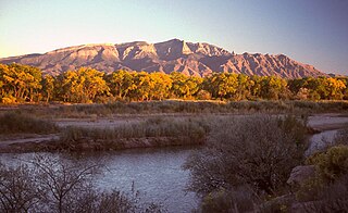
The Sandia Mountains are a mountain range located in Bernalillo and Sandoval counties, immediately to the east of the city of Albuquerque in New Mexico in the southwestern United States. The mountains are just due south of the southern terminus of the Rocky Mountains, and are part of the Sandia–Manzano Mountains. This is largely within the Cibola National Forest and protected as the Sandia Mountain Wilderness. The highest point is Sandia Crest, 10,678 feet (3,255 m).
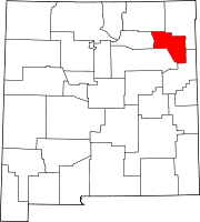
Mora or Santa Gertrudis de lo de Mora is a census-designated place in, and the county seat of, Mora County, New Mexico. It is located about halfway between Las Vegas and Taos on Highway 518, at an altitude of 7,180 feet. The Republic of Texas performed a semi-official raid on Mora in 1843. Two short battles of the Mexican–American War were fought in Mora in 1847, where U.S. troops eventually defeated the Hispano and Puebloan militia, effectively ending the Taos Revolt in the Mora Valley. The latter battle destroyed most of the community, necessitating its re-establishment.

The Laguna Pueblo is a federally recognized tribe of Native American Pueblo people in west-central New Mexico, near the city of Albuquerque, in the United States. Part of the Laguna territory is included in the Albuquerque metropolitan area, chiefly around Laguna's Route 66 Resort and Casino. The name, Laguna, is Spanish and derives from the lake on their reservation. This body of water was formed by an ancient dam that was constructed by the Laguna people. After the Pueblo Revolt of 1680–1696, the Mission San José de la Laguna was erected by the Spanish at the old pueblo and finished around July 4, 1699.

Sandia Crest, also known locally as Sandia Peak or simply as the Crest, is a mountain ridge that, at 10,679 feet (3,255 m), is the highpoint of the Sandia–Manzano Mountains, and is located in the Sandia Mountains of Bernalillo County, New Mexico, United States. Instead of a true summit or topographic peak, this range climbs to a long ridge line. To the east, the range slopes down from the Crest and merges into the plains below. On the west side of the Crest is a cliff; the range dramatically drops over 4,000 feet in elevation over 2 miles of horizontal distance to the Rio Grande Valley and city of Albuquerque below. It is within the Sandia Ranger District of the Cibola National Forest. The Crest features a viewing area with a shop and visitor center, telecommunications transmitters, the popular La Luz Trail, the Sandia Mountain Wilderness, and the summit of Sandia Peak Ski Area and the Sandia Peak Tramway, which is the longest aerial tramway in the Americas.
The Santa Fe New Mexican or simply The New Mexican is a daily newspaper published in Santa Fe, New Mexico. Dubbed "the West's oldest newspaper," its first issue was printed on November 28, 1849.
La Cueva is an unincorporated community on the Mora River in Mora County, New Mexico, United States, situated at the intersection of New Mexico State Roads 442 and 518.
Lingo is a populated place in Roosevelt County, New Mexico, United States, located at latitude 33.7884278 and longitude -103.1146674, at 3,986 feet of elevation. The original name given the settlement in 1916 was “Need”, but U.S. postal authorities said that was too much like “Weed” in Otero County, so in 1918 the name was changed to "Lingo".
Gladstone is an unincorporated layover in Union County, New Mexico, United States, founded in 1880. It lies at the intersection of US Route 56 and Union County Road C001. The post office, which opened in 1888, closed in 2010, leaving only a general store with gas service, and two houses, located there. The rest of the community has reverted to private ranch land.
Solano is an unincorporated community in Harding County, New Mexico, United States, founded in 1907. It lies along NM 39 and the tracks of a spur of the Southern Pacific Railroad about half-way between Roy and Mosquero. The post office was opened in 1907.
Separ is an unincorporated desert hamlet in Grant County in the bootheel of southwestern New Mexico, in the southwestern United States. Although it is called a ghost town by some on the internet, it currently has a small population. Separ lies in the endorheic Guzmán Basin; as a result the continental divide passes both to the west and east of it. Located alongside the tracks of the Union Pacific, it flourished in the late 19th and early 20th century as a watering station and livestock transfer point. Separ is located alongside Interstate 10, about 20 miles southeast of Lordsburg and 48 miles west of Deming. Today it is a "service point for truck and car traffic."
Borrego Pass is an unincorporated community consisting of two Navajo communities and a trading post in the Navajo lands of McKinley County, in northwestern New Mexico, United States. In Navajo its name is Dibé Yázhí Habitiin, meaning "Upward Path of the Lamb."
Weed is a hamlet and a census-designated place in Otero County, New Mexico, United States. It lies alongside New Mexico State Road 24 on the southeastern slopes of the Sacramento Mountains at an elevation of 7,047 ft. It has had a Post Office since 1885. As of the 2010 census, its population was 63.
Piñon is an unincorporated ranching community in Otero County in southern New Mexico, in the southwestern United States. The town is in the pinon-juniper shrublands habitat with an altitude of 6,060 feet. It is located at the intersection of NM Route 24 and NM Route 506. The postoffice in Piñon opened in 1907. In 2014, Piñon was ranked as the most politically conservative town in New Mexico.

Territorial Style was an architectural style of building developed and used in Santa Fe de Nuevo México, popularized after the founding of Albuquerque in 1706. Reintroduced during the New Mexico Territory from the time of the Mexican and American territorial phases in 1821 until 1912, at which time New Mexico stopped being a territory and became a US state. Following the increase of its popularity in the 1930s and 1940s, it became referred to as the Territorial Revival style, which became another popular building style alongside New Mexico's Pueblo Revival style.
The following is a timeline of the history of the city of Albuquerque, New Mexico, US.
Riverside is an unincorporated community in Grant County, New Mexico, United States. It lies on the left (east) bank of the Gila River and on both sides of U.S. Route 180 in southwestern New Mexico, 2.6 miles (4.2 km) by road south of Cliff.

The Pit is an indoor arena in Albuquerque, New Mexico, serving primarily as the home venue of the University of New Mexico Lobos basketball teams. The facility opened in 1966 as University Arena but gained the nickname "The Pit" due to its innovative subterranean design, with its playing floor 37 feet (11 m) below street level. The arena is located on the UNM South Campus and has a seating capacity of 15,411 for basketball and up to 13,480 for concerts, with 40 luxury suites and 365 club seats.


