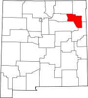
Union County is the northeasternmost county in the U.S. state of New Mexico. As of the 2020 census, the population was 4,079, making it the fourth-least populous county in New Mexico. Its county seat is Clayton. The county was formed in 1894. Union County borders Colorado to the north, and Oklahoma and Texas to the east.

San Miguel County is a county in the U.S. state of New Mexico. As of the 2020 census, the population was 27,201. Its county seat is Las Vegas.
Roosevelt County is a county located in the U.S. state of New Mexico. As of the 2020 census, the population was 19,191. Its county seat is Portales. The county was created in 1903 from Chaves and Guadalupe counties and named for the then-current President of the United States, Theodore Roosevelt. The county's eastern border is the Texas state line.
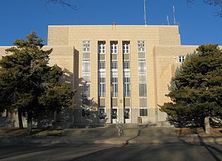
Quay County is a county in the state of New Mexico. As of the 2020 U.S. census, the population was 8,746. Its county seat is Tucumcari. The county was named for Pennsylvania senator Matthew Quay, who supported statehood for New Mexico. Its eastern border is the Texas state line, approximately 103.04 degrees west longitude.

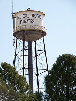
Harding County is a county in the U.S. state of New Mexico. As of the 2020 census, the population was 657, making it the least populous county in the state, and the 13th-smallest county by population in the United States. Its county seat is Mosquero. The county is named for United States President Warren G. Harding, and was created on the day of his inauguration as president on March 4, 1921, making him the last president to have a county named after him.

Curry County is a county located in the U.S. state of New Mexico. As of the 2020 census, its population was 48,430. Its county seat is Clovis. The county is named in honor of George Curry, territorial governor of New Mexico from 1907 to 1910.

Diller is a village in Jefferson County, Nebraska, United States. The population was 248 at the 2020 census.

Cedar Crest is a census-designated place (CDP) in Bernalillo County, New Mexico, United States. The population was 958 at the 2010 census. It is part of the Albuquerque Metropolitan Statistical Area.

North Acomita Village is a census-designated place (CDP) in Cibola County, New Mexico, United States. The population was 303 at the 2010 census.

Melrose is a village in Curry County, New Mexico, United States. Its population was 651 at the 2010 census. The town is losing population due to rural exodus. Melrose is served by Melrose Elementary School and Melrose High School.
Hatch is a village in Doña Ana County, New Mexico, United States. The population was 1,648 at the 2010 census. The town is experiencing moderate growth, along with its outliers of Salem, Arrey, Derry, and Rincon. Hatch is widely known as the "best chile place in the World," for growing a wide variety of peppers, especially the New Mexican cuisine staple, and one of New Mexico's state vegetables, the New Mexico chile.

Hope is a village in Eddy County, New Mexico, United States. It is located approximately 20 miles (32 km) west of Artesia on U.S. Route 82. It has had a post office since 1890. As of the 2010 census, the village's population was 105.

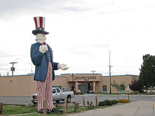
Roy is a village in Harding County, New Mexico, United States. The population was 234 at the 2010 census.

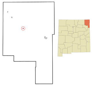
House is a village in Quay County, New Mexico, United States. The population was 68 at the 2010 census.
Logan is a village in Quay County, New Mexico, United States. The population was 1,042 at the 2010 census.

Cuyamungue is a census-designated place (CDP) in Santa Fe County, New Mexico, United States. It is part of the Santa Fe, New Mexico Metropolitan Statistical Area. The population was 479 at the 2010 census.
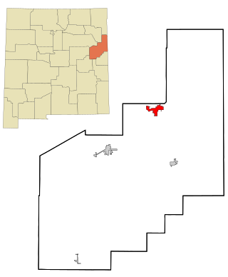
Grenville is a village in Union County, New Mexico, United States. The population was 38 at the 2010 census.

Three Way is a city in Madison County, Tennessee. The population was 1,709 at the 2010 census. It is included in the Jackson, Tennessee Metropolitan Statistical Area.

Timberville is a town in Rockingham County, Virginia, United States. The population was 2,522 at the 2010 census, which was a significant increase from the 1,739 reported in the 2000 census. It is part of the Harrisonburg Metropolitan Statistical Area.

Gamerco, also called in Navajo: Łigaiyaaʼáhí, is an unincorporated community in McKinley County, New Mexico, United States. As of the 2010 Census, the community population was 1,956. Gamerco was used as a base for coal mining until the 1960s.