
Tierra Amarilla is a census-designated place in and the county seat of Rio Arriba County, New Mexico, United States.

San Miguel County is a county in the U.S. state of New Mexico. As of the 2020 census, the population was 27,201. Its county seat is Las Vegas.

Carnuel is a census-designated place (CDP) in Bernalillo County, New Mexico, United States. The population was 1,232 at the 2010 Census. It is part of the Albuquerque Metropolitan Statistical Area. Robert Julyan theorizes that name of the community, which has been spelled both Carnuel and Carnué, derives from the Tiwa word for "badger place."

Pecos National Historical Park is a United States National Historical Park in San Miguel County, New Mexico. The park, operated by the National Park Service, encompasses thousands of acres of landscape infused with historical elements from prehistoric archaeological ruins to 19th-century ranches, to a battlefield of the American Civil War. Its largest single feature is Pecos Pueblo also known as Cicuye Pueblo, a Native American community abandoned in historic times. First a state monument in 1935, it was made Pecos National Monument in 1965, and greatly enlarged and renamed in 1990. Two sites within the park, the pueblo and the Glorieta Pass Battlefield, are National Historic Landmarks.
Genízaros was the name for detribalized Native Americans (Indians) from the 17th to 19th century in the Spanish colony of New Mexico and neighboring regions of the American southwest. Genízaros were usually women and children who had been captured in war by the Spanish or purchased from Indian tribes who had held them captive as slaves. To circumvent Spanish laws forbidding slavery, the purchaser of a genízaro had the obligation to introduce them to Christianity and Spanish customs. Genízaros worked as indentured servants, shepherds, and laborers. They occupied the lowest rung of status-conscious Spanish society in New Mexico but slowly assimilated and intermarried into Spanish and later Mexican (1821-1846) and American society. The descendants of genízaros are also called genízaros and the word has become a term of pride for the descendants of the original Indian captives and slaves. In 1793, genízaros are estimated to have comprised up to one third of the 29,041 people living under Spanish rule in New Mexico.
Truchas is a census-designated place in Rio Arriba County, New Mexico, United States. Located along the scenic High Road to Taos, it is halfway between Santa Fe in the south, and Taos to the north.

Ribera is an unincorporated community and census-designated place in San Miguel County, New Mexico. Located in the northern part of the state, it is at the foot of Rowe Mesa and along the Pecos River, 50 miles (80 km) southeast of Santa Fe.
Land grants in New Mexico and Colorado were awarded to individuals and communities by the Spanish and Mexican governments to encourage settlement and expansion of the Territorio de Nuevo Mexico, which included southern Colorado. Land grants by the Spanish and Mexicans between 1692 and 1846 numbered 291 in New Mexico, four partly in New Mexico and partly in Colorado, and three in Colorado. The land area of grants totaled tens of thousands of square miles. "The two major types of land grants were private grants made to individuals, and communal grants made to groups of people for the purpose of establishing settlements. Communal land grants were also made to Pueblos for the lands they inhabited." The majority of the land area within grants was designated as common land for residents. Common land was mostly used for grazing cattle and sheep. Smaller acreages within the grants were devoted to irrigation agriculture and home sites. The principal objectives of the land grants were to encourage the foundation of new communities and to expand the settled area on the frontiers of New Mexico for defense from Indian raids.

Villanueva State Park is a state park of New Mexico, United States, located on the banks of the Pecos River. The park features red and yellow sandstone cliffs, cottonwood trees, and other native plants. Villanueva State Park's elevation is 6,110 feet above sea level. The park sits in the shift from The Rocky Mountains and The Great Plains. The park is located southwest of the town of Las Vegas, 35 miles (56 km) New Mexico. While on the lookout trails of Villanueva State Park, one would be able to view the Pecos River. Water in the Pecos River south headed to Villanueva State Park, there are showed signs of base metals and mercury. Elevated levels of copper, lead, and zinc.
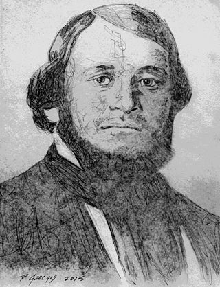
José Guadalupe Gallegos was a native New Mexican military leader, county sheriff, rancher and politician. In 1854 he served as brigadier general in the volunteer Mounted Militia of New Mexico (Territory) formed for the purpose of protecting communities against Native American attacks. Prior to the Battle of Glorieta Pass, he was a Union field and staff Colonel in the Civil War, serving as commander of the 3rd New Mexico Volunteer Infantry and as commander of the Hatch's Ranch military post. He represented San Miguel County in four of the six Assemblies of the Territorial Legislature between 1855-1861 and served as House Speaker and as Council President. José was one of the founding members of the Historical Society of New Mexico and was a founding associate in the incorporation of the Montezuma Copper Mining Company of Santa Fé, New Mexico the New Mexican Railway Company and the New Mexico Wool Manufacturing Company.

A Cibolero was a Spanish colonial buffalo hunter from New Mexico. The Spanish word for buffalo as used in New Mexico is cibolo; hence, the name Cibolero for buffalo hunter.

San Miguel del Vado is an unincorporated community in San Miguel County, New Mexico, United States.

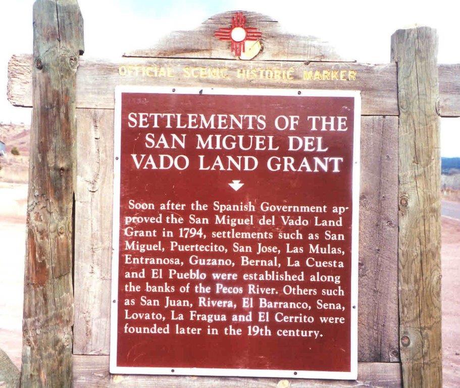
The San Miguel del Vado Land Grant is one of the Spanish land grants in New Mexico. On November 24, 1794, 53 men submitted a petition for land and were granted temporary possession on November 24, 1794, pending satisfaction of prescribed criteria. A second grant was obtained by 58 men and their respective families on March 12, 1803. Two days later, the procedure was repeated at San José del Vado, 6 kilometres (3.7 mi) north of San Miguel del Vado, distributing farm land to an additional 47 heads of household, including two women.

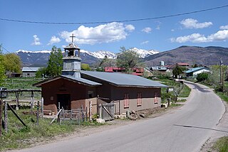
El Cerrito is a village in San Miguel County, New Mexico, United States. The village is located in the upper Pecos River valley and was founded in 1824 by settlers from Villanueva, 5 kilometres (3.1 mi) upstream. The majority of the population is Hispanic.

Fernando Chacón was a Spanish soldier who served as a governor of Santa Fe de Nuevo México, modern day New Mexico, between 1794 and 1804. He was a Knight of the Order of Santiago.
San Jose is a census-designated place in San Miguel County, New Mexico, United States. Its population was 137 as of the 2010 census. San Jose has a post office, with ZIP code 87565. Exit 319 of Interstate 25 serves the community.
Anton Chico, or Anton Chico Abajo or Anton Chico de Abajo, is a census-designated place in Guadalupe County, New Mexico, United States. Its population was 188 as of the 2010 census, of which 167 were Hispanic in origin. Anton Chico has a post office with ZIP code 87711. New Mexico State Road 386 passes through the community. Anton Chico is listed in the National Register of Historic Places.
Sena is an unincorporated community and census-designated place in San Miguel County, New Mexico, United States. It is located along the Pecos River and New Mexico State Highway 3.
Slavery in New Mexico existed among the Native American (Indian) tribes prior to the arrival of the first Europeans. In 1542, the Spanish king banned the enslavement of the Indians of the Americas in Spanish colonies, but the ban was mostly ineffective. The enslavement of Indians was common during the Spanish exploration and colonization of New Mexico from 1540 to 1821. Slaves of the Spanish included a few of the Pueblos living in the Spanish colony, but most slaves were captured from other Indian tribes in the region. Women were more valued than men as slaves. Slaves were not only valued for their labour, but were also a prestige item among the more prominent and prosperous of the Spanish colonists. Enslavement of an individual was not always permanent. Slaves, especially women, often gained kinship relationships with their owners. The offspring and descendants of enslaved persons were called genizaros and made up one-third of New Mexico's population in the early 19th centuries. In the Spanish caste system genizaros had low status, but were important for frontier defense and cultural contacts with Indian tribes. Forced labor and debt peonage were also features of slavery in New Mexico. Some Indians captured and enslaved in New Mexico were sent south to work in Mexican mines or even to distant places like Cuba to work on sugar plantations.
Llano del Medio is an unincorporated community and census-designated place in Guadalupe County, New Mexico, United States. Its population was 118 as of the 2010 census, of which 111 people were Hispanic in origin. New Mexico State Road 119 passes through the community.


