Santa Rosa, New Mexico

Last updated

Santa Rosa, New Mexico
Guadalupe Courthouse New.jpg
New wing, Guadalupe County Courthouse
Guadalupe County New Mexico Incorporated and Unincorporated areas Santa Rosa Highlighted.svg
Location of Santa Rosa, New Mexico
Usa edcp location map.svg
Red pog.svg
Santa Rosa, New Mexico
Location in the United States
Coordinates: 34°56′32″N104°41′2″W / 34.94222°N 104.68389°W / 34.94222; -104.68389
Country United States
State New Mexico
County Guadalupe
Named for Rose of Lima
Government
  MayorNelson Kotiar
Area
[1]
  Total5.02 sq mi (13.01 km2)
  Land5.00 sq mi (12.95 km2)
  Water0.03 sq mi (0.06 km2)
Elevation
4,616 ft (1,407 m)
Population
 (2020) [2]
  Total2,850
  Density570.11/sq mi (220.13/km2)
Time zone UTC-7 (Mountain (MST))
  Summer (DST) UTC-6 (MDT)
ZIP code
88435
Area code 575
FIPS code 35-70670
GNIS feature ID0918353
Website santarosanm.org
The historic Guadalupe County courthouse in Santa Rosa was built in 1909. New wing visible at left. Santa Rosa Courthouse.jpg
The historic Guadalupe County courthouse in Santa Rosa was built in 1909. New wing visible at left.

Santa Rosa is a city in and the county seat of Guadalupe County, New Mexico, United States. [3] The population was 2,848 at the 2010 census. [4] It lies between Albuquerque and Tucumcari, situated on the Pecos River at the intersection of Interstate 40 and U.S. Route 54 and 84. The city is located on the western edge of the Llano Estacado or "staked plains" of eastern New Mexico and west Texas.

Contents

History

The first Euro-American settlement in the area was Agua Negra Chiquita[ citation needed ], "Little Black Water" in Spanish, in 1865. The name was changed in 1890 to Santa Rosa (Spanish for "Saint Rose"), referring to a chapel that Don Celso Baca (the founder of the city) built and named after both his mother Rosa and Saint Rose of Lima. [5] The "Rosa" may also refer to the roses in the story of Our Lady of Guadalupe and is indicative of the Catholicism of the Spanish colonizers who settled in the area.

At the turn of the twentieth century, Santa Rosa was not the largest settlement within the region. Puerto de Luna, approximately ten miles south, held the county seat for Guadalupe County. Santa Rosa was smaller than Puerto de Luna until 1901 when the Chicago, Rock Island & Pacific Railroad was built into Santa Rosa from the east, quickly followed by arrival of the El Paso and Northeastern Railway in February 1902, from the southwest, thereby creating a transcontinental connection. [6] As the terminus and interchange point of the two railroads, a thriving community quickly developed (The interchange was moved to Tucumcari after 1907). The county seat was moved to Santa Rosa from PDL in 1903.

The east–west highway through the town was designated as U.S. Route 66 in 1926, and the increase in traffic made the community a popular rest stop with motels and cafes. Santa Rosa's stretch of Route 66 is part of film history. When John Steinbeck's epic novel, The Grapes of Wrath , was made into a movie, director John Ford used Santa Rosa for the memorable train scene. Tom Joad (Henry Fonda) watches a freight train steam over the Pecos River railroad bridge, into the sunset. It was also one of the shooting scenes for Bobbie Jo and the Outlaw starring Lynda Carter in the role of Bobbi Jo.

Santa Rosa was the childhood home of author Rudolfo Anaya, and is the basis for the fictional town of Guadalupe in his autobiographical novel Bless Me, Ultima .

Santa Rosa and other towns such as Vaughn and Fort Sumner in 1954. NM Fort Sumner 190662 1954 250000 geo.jpg
Santa Rosa and other towns such as Vaughn and Fort Sumner in 1954.

Geography

Santa Rosa has many natural lakes, an anomaly in the dry desert climate surrounding it. These are sinkholes that form in the limestone bedrock of the area and fill with water, and thus the lakes are connected by a network of underground, water-filled tunnels. The most famous of these is Blue Hole, a popular spot for diving, where cool 61 °F (16 °C) water forms a lake over 81 feet (25 m) deep.

Santa Rosa is located near the center of Guadalupe County at 34°56′32″N104°41′2″W / 34.94222°N 104.68389°W / 34.94222; -104.68389 (34.942166, -104.683981). [7]

According to the United States Census Bureau, the city has a total area of 5.0 square miles (12.9 km2), of which 0.03 square miles (0.07 km2), or 0.52%, is water. [4]

Climate

Santa Rosa experiences a semi-arid climate (Köppen climate classification BSk).

Climate data for Santa Rosa, New Mexico
MonthJanFebMarAprMayJunJulAugSepOctNovDecYear
Mean daily maximum °F (°C)53.5
(11.9)
58.2
(14.6)
64.9
(18.3)
73.6
(23.1)
81.6
(27.6)
90.4
(32.4)
91.9
(33.3)
90.0
(32.2)
84.3
(29.1)
74.9
(23.8)
62.6
(17.0)
54.3
(12.4)
73.3
(22.9)
Mean daily minimum °F (°C)24.8
(−4.0)
27.5
(−2.5)
32.7
(0.4)
40.5
(4.7)
49.3
(9.6)
58.1
(14.5)
62.7
(17.1)
61.2
(16.2)
53.8
(12.1)
42.5
(5.8)
31.7
(−0.2)
25.7
(−3.5)
42.5
(5.8)
Average precipitation inches (mm)0.39
(9.9)
0.44
(11)
0.64
(16)
0.80
(20)
1.54
(39)
1.56
(40)
2.31
(59)
2.60
(66)
1.64
(42)
1.26
(32)
0.52
(13)
0.60
(15)
14.31
(363)
Average snowfall inches (cm)2.9
(7.4)
2.5
(6.4)
1.0
(2.5)
0.6
(1.5)
0.1
(0.25)
0.0
(0.0)
0.0
(0.0)
0.0
(0.0)
0.0
(0.0)
0.3
(0.76)
1.3
(3.3)
4.0
(10)
12.6
(32)
Source: WRCC [8]

Transport

Highways

Interstate 40 serves the city with three exits (273, 275, and 277); the highway leads east 59 miles (95 km) to Tucumcari and west 115 miles (185 km) to Albuquerque. U.S. Route 84 leads southeast 44 miles (71 km) to Fort Sumner, and U.S. Route 54 leads southwest 40 miles (64 km) to Vaughn.

"Route 66" remains the name of the main east–west thoroughfare through the city, referring to former U.S. Route 66, which lost its official designation in 1985.

New Mexico State Road 91 runs south to Puerto de Luna.

Railroad

Union Pacific provides freight service. No passenger service has been available since 1968.

Airport

Santa Rosa Route 66 Airport is located east of the city. Currently there is no scheduled passenger service.

Demographics

Historical population
CensusPop.Note
1920 1,093
1930 1,1273.1%
1940 2,310105.0%
1950 2,199−4.8%
1960 2,2201.0%
1970 2,48511.9%
1980 2,469−0.6%
1990 2,263−8.3%
2000 2,74421.3%
2010 2,8483.8%
2020 3,0075.6%
U.S. Decennial Census [9] [2]
Downtown Santa Rosa Santa Rosa New Mexico downtown.JPG
Downtown Santa Rosa

As of the census [10] of 2000, there were 2,744 people, 898 households, and 616 families residing in the city. The population density was 645.7 inhabitants per square mile (249.3/km2). There were 1,024 housing units at an average density of 241.0 per square mile (93.1/km2). The racial makeup of the city was 57.47% White, 2.19% African American, 1.75% Native American, 0.87% Asian, 0.04% Pacific Islander, 33.13% from other races, and 4.56% from two or more races. Hispanic or Latino of any race were 81.16% of the population.

There were 898 households, out of which 35.0% had children under the age of 18 living with them, 45.1% were married couples living together, 18.3% had a female householder with no husband present, and 31.3% were non-families. 28.0% of all households were made up of individuals, and 11.2% had someone living alone who was 65 years of age or older. The average household size was 2.50 and the average family size was 3.03.

In the city, the population was spread out, with 23.1% under the age of 18, 10.4% from 18 to 24, 34.4% from 25 to 44, 20.0% from 45 to 64, and 12.0% who were 65 years of age or older. The median age was 36 years. For every 100 females, there were 135.1 males. For every 100 females age 18 and over, there were 145.2 males.

The median income for a household in the city was $25,085, and the median income for a family was $28,782. Males had a median income of $20,161 versus $16,417 for females. The per capita income for the city was $11,168. About 18.9% of families and 23.2% of the population were below the poverty line, including 27.5% of those under age 18 and 23.9% of those age 65 or over.

Education

Its school district is Santa Rosa Consolidated Schools. [11] It operates Santa Rosa Elementary School, Santa Rosa Middle School, and Santa Rosa High School. [12]

Sports

Santa Rosa High School's football team won back-to-back-to-back state championships in the 2010, 2011, and 2012 AA state championships. The 2010 and 2011 victories were won against teams which were undefeated until the championship. In 2010 the Santa Rosa Lions beat the Tularosa Wildcats, and in 2011 the Santa Rosa Lions beat the Eunice Cardinals. In 2012, the Santa Rosa Lions went undefeated, shutting out the Tularosa Wildcats in the championship. The Lions also won championships in 1955, 1993, 1996, 1998, and 2007. [13] Santa Rosa High School was also among the first in the country to establish a lawn mower racing club.

Notable people

Related Research Articles

<span class="mw-page-title-main">San Miguel County, New Mexico</span> County in New Mexico, United States

San Miguel County is a county in the U.S. state of New Mexico. As of the 2020 census, the population was 27,201. Its county seat is Las Vegas.

<span class="mw-page-title-main">Quay County, New Mexico</span> County in New Mexico, United States

Quay County is a county in the state of New Mexico. As of the 2020 U.S. census, the population was 8,746. Its county seat is Tucumcari. The county was named for Pennsylvania senator Matthew Quay, who supported statehood for New Mexico. Its eastern border is the Texas state line, approximately 103.04 degrees west longitude.

<span class="mw-page-title-main">Otero County, New Mexico</span> County in New Mexico, United States

Otero County is a county located in the U.S. state of New Mexico. As of the 2020 census, the population was 67,839. Its county seat is Alamogordo. Its southern boundary is the Texas state line. It is named for Miguel Antonio Otero, the territorial governor when the county was created.

<span class="mw-page-title-main">Lincoln County, New Mexico</span> County in New Mexico, United States

Lincoln County is a county in the U.S. state of New Mexico. As of the 2020 census, the population was 20,269. Its county seat is Carrizozo, while its largest community is Ruidoso.

<span class="mw-page-title-main">Guadalupe County, New Mexico</span> County in New Mexico, United States

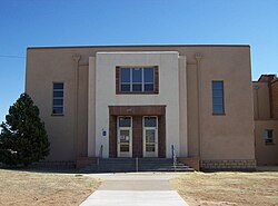
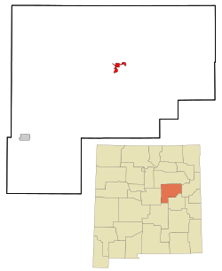
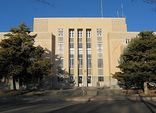
Guadalupe County is a county in the U.S. state of New Mexico. As of the 2020 census, the population was 4,452. Its county seat is Santa Rosa.

<span class="mw-page-title-main">Catron County, New Mexico</span> County in New Mexico, United States

Catron County is a county in the U.S. state of New Mexico. As of the 2020 census, the population was 3,579, making it New Mexico's third-least populous county. Its county seat is Reserve. Catron County is New Mexico's largest county by area.

<span class="mw-page-title-main">Guadalupe, California</span> City in California, United States

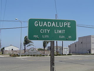
Guadalupe is a small city located in Santa Barbara County, California. According to the U.S. Census of 2010, the city has a population of 7,080. Guadalupe is economically and socially tied to the city of Santa Maria, which is about 8 miles (13 km) to the east. It is located at the intersection of Highway 1 and Highway 166, immediately south of the Santa Maria River, and 5 miles (8 km) east of the Pacific Ocean.

<span class="mw-page-title-main">Durham, Kansas</span> City in Marion County, Kansas

Durham is a city in Marion County, Kansas, United States. As of the 2020 census, the population of the city was 89. The city took its name from Durham cattle. It is located about 8.5 miles (14 km) north of Hillsboro on the west side of K-15 highway next to a railroad.

<span class="mw-page-title-main">Galva, Kansas</span> City in McPherson County, Kansas

Galva is a city in McPherson County, Kansas, United States. As of the 2020 census, the population of the city was 834.

<span class="mw-page-title-main">Tijeras, New Mexico</span> Village in New Mexico, United States

Tijeras is a village in Bernalillo County, New Mexico, United States. The population was 541 at the 2010 census. It is part of the Albuquerque metropolitan area.

<span class="mw-page-title-main">Lake Sumner, New Mexico</span> Census-designated place in De Baca County, New Mexico, United States

Lake Sumner is a census-designated place (CDP) in De Baca County, New Mexico, United States. The population was 143 at the 2010 census, up from the figure of 86 recorded in 2000.

<span class="mw-page-title-main">Vaughn, New Mexico</span> Town in New Mexico, United States

Vaughn is a town in Guadalupe County, New Mexico, United States. The population was 446 at the 2010 census, down from the figure of 539 recorded in 2000. It is located at an intersection of the Burlington Northern Santa Fe and Union Pacific railroad lines.

<span class="mw-page-title-main">La Luz, New Mexico</span> CDP in New Mexico, United States

La Luz is a census-designated place (CDP) in Otero County, New Mexico, United States. The population was 1,615 at the 2000 census. It is located immediately north of Alamogordo and lies in the eastern edge of the Tularosa Basin and on the western flank of the Sacramento Mountains. Until 1848, La Luz was a part of Mexico. The CDP gets its name from the Spanish word for "light."

<span class="mw-page-title-main">Tularosa, New Mexico</span> Village in New Mexico, United States

Tularosa is a village in Otero County, New Mexico, United States. It shares its name with the Tularosa Basin, in which the town is located. To the east, Tularosa is flanked by the western edge of the Sacramento Mountains. The population was 2,553 at the 2020 census. During the 1990s and early 2000s, the town, north of the much larger Alamogordo, experienced moderate growth and construction as a bedroom community, especially in the housing industry. Tularosa is noted for its abundance of cottonwood shade trees and its efforts to preserve the adobe-style architecture of its past.

<span class="mw-page-title-main">San Jon, New Mexico</span> Village in New Mexico, United States

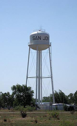
San Jon ( is a village in Quay County, New Mexico, United States. The population was 216 at the 2010 census.

<span class="mw-page-title-main">Tucumcari, New Mexico</span> City in the United States

Tucumcari is a city in and the county seat of Quay County, New Mexico, United States. The population was 5,278 at the 2020 census. Tucumcari was founded in 1901, two years before Quay County was established.

<span class="mw-page-title-main">Edgewood, New Mexico</span> Town in New Mexico, United States

Edgewood is a town in Santa Fe County, New Mexico, United States. Through annexations, its town boundaries now extend into Bernalillo and Sandoval counties. It is part of the Albuquerque–Santa Fe–Las Vegas combined statistical area.

<span class="mw-page-title-main">Northampton, Pennsylvania</span> Borough in Pennsylvania, United States

Northampton is a borough in Northampton County, Pennsylvania. Its population was 10,395 as of the 2020 census. Northampton is located 7.8 miles (12.6 km) north of Allentown, 66.7 miles (107.3 km) northwest of Philadelphia, and 93.8 miles (151.0 km) west of New York City.

<span class="mw-page-title-main">Santa Rosa, Texas</span> Town in Texas, United States

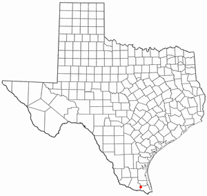
Santa Rosa is a town in Cameron County, Texas, United States. The population was 2,873 at the 2010 census. It is part of the Brownsville–Harlingen–Raymondville and the Matamoros–Brownsville metropolitan areas.

Pastura is a small unincorporated community and census-designated place (CDP) in Guadalupe County, New Mexico, United States, approximately halfway between Santa Rosa and Vaughn. As of the 2010 census it had a population of 23.

References

  1. "ArcGIS REST Services Directory". United States Census Bureau. Retrieved October 12, 2022.
  2. 1 2 "Census Population API". United States Census Bureau. Retrieved October 12, 2022.
  3. "Find a County". National Association of Counties. Retrieved June 7, 2011.
  4. 1 2 "Geographic Identifiers: 2010 Demographic Profile Data (G001): Santa Rosa city, New Mexico". American Factfinder. U.S. Census Bureau. Retrieved December 23, 2016.[ dead link ]
  5. Pearce, T.M.,editor, New Mexico Place Names, A Geographical Dictionary, University of New Mexico Press 1965. ISBN   0-8263-0082-0
  6. Myrick, David F. (1990). New Mexico's Railroads: A Historical Survey (revised ed.). Albuquerque, NM.: University of New Mexico Press. ISBN   0-8263-1185-7.
  7. "US Gazetteer files: 2010, 2000, and 1990". United States Census Bureau. February 12, 2011. Retrieved April 23, 2011.
  8. "SANTA ROSA, NEW MEXICO Monthly Climate Summary 01/01/1908 to 09/30/2012". Western Regional Climate Center. September 30, 2012. Retrieved October 13, 2018.
  9. "Census of Population and Housing". Census.gov. Retrieved September 4, 2022.
  10. "U.S. Census website". United States Census Bureau . Retrieved January 31, 2008.
  11. "2020 CENSUS - SCHOOL DISTRICT REFERENCE MAP: Guadalupe County, NM" (PDF). U.S. Census Bureau . Retrieved September 4, 2022.
  12. "Home". Santa Rosa Consolidated Schools. Retrieved September 4, 2022. - See drop-down menu that lists the schools - Archived on Ghost Archive
  13. "New Mexico State Football Champions" (PDF).

Further reading