
Victoria County is a county located in the U.S. state of Texas. As of the 2020 census, its population was 91,319. Its county seat is Victoria. Victoria County is included in the Victoria, TX Metropolitan Statistical Area.

Guadalupe County is a county in the U.S. state of New Mexico. As of the 2010 census, the population was 4,687, making it the fifth-least populous county in New Mexico. Its county seat is Santa Rosa.

Morris County is a county located in the U.S. state of Kansas. As of the 2020 census, the county population was 5,386. The largest city and county seat is Council Grove.

Roseland is a neighborhood in Santa Rosa, California. As of the 2010 census, the population was 6,325. Roseland was an unincorporated enclave within the City of Santa Rosa until the area was annexed by Santa Rosa on November 1, 2017.
Santa Rosa is a city in and the county seat of Guadalupe County, New Mexico, United States. The population was 2,848 at the 2010 census. It lies between Albuquerque and Tucumcari, situated on the Pecos River at the intersection of Interstate 40 and U.S. Route 54 and 84. The city is located on the western edge of the Llano Estacado or "staked plains" of eastern New Mexico and west Texas.

Vaughn is a town in Guadalupe County, New Mexico, United States. The population was 446 at the 2010 census, down from the figure of 539 recorded in 2000. It is located at an intersection of the Burlington Northern Santa Fe and Union Pacific railroad lines.

Madrid is a census-designated place (CDP) in Santa Fe County, New Mexico, United States. It is part of the Santa Fe, New Mexico Metropolitan Statistical Area. The population was 149 at the 2000 census and 204 in 2010. Today, Madrid has become an artists' community with galleries lining New Mexico State Road 14. It retains remnants of its history with the Mineshaft Tavern and the Coal Mine Museum.

Island Pond is a census-designated place (CDP) in the town of Brighton in Essex County, Vermont, United States. The population was 750 at the 2020 census. It is part of the Berlin, NH–VT Micropolitan Statistical Area.

Felt is a small unincorporated community and census-designated place (CDP) in Cimarron County, Oklahoma, United States. As of the 2010 census it had a population of 93. It was named for C.F.W. Felt of the Santa Fe Railroad. Nearby is the Cedar Breaks Archeological District, included on the National Register of Historic Places listings in Cimarron County, Oklahoma. The community is served by a post office and a school.
Gordonville is an unincorporated community and census-designated place (CDP) in Leacock Township, Lancaster County, Pennsylvania, United States. The population was 508 as of the 2010 census. Though the village is little known outside its immediate area, the surrounding countryside has been portrayed in many books and magazine articles. The Old Order Amish constitute a significant cultural presence in the area of the village. Wendell Berry mentioned the town in one of his collections of essays.

Helendale or Silver Lakes is an unincorporated community and census-designated place located in the Victor Valley of the Mojave Desert, within San Bernardino County, California.

Montello is a census-designated place (CDP) in Elko County, Nevada, United States. It is home to Montello Elementary School, which is part of the Elko County School District. The population of Montello was 50 as of the 2018 American Community Survey. Two small bars and a market/motel selling fuel and sundries comprise the business district. Various cattle ranching operations surround the area.

Yucca is an unincorporated community and census-designated place (CDP) in Mohave County, Arizona, United States. As of the 2020 census it had a population of 96, down from 126 at the 2010 census.
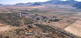
Rodeo is a census-designated place (CDP) in Hidalgo County, New Mexico, United States, at 31°50′13″N109°01′54″W. It lies less than one mile (1.6 km) from the border with Arizona on New Mexico State Road 80. As of the 2010 census, the population of Rodeo was 101.
Puerto de Luna is a census-designated place (CDP) in Guadalupe County, New Mexico, United States. It lies approximately 9+1⁄2 miles (15.3 km) south-southeast of Santa Rosa on New Mexico State Road 91 and on the bank of the Pecos River. The community is located west of, but not within, the Llano Estacado of Eastern New Mexico and West Texas.
Barton is a census-designated place (CDP) in Bernalillo and Santa Fe counties, New Mexico, United States. It was first listed as a CDP prior to the 2020 census.
Center Point is an unincorporated community and census-designated place (CDP) in San Juan County, New Mexico, United States. It was first listed as a CDP prior to the 2020 census.
Encantado is an unincorporated community and census-designated place (CDP) in Santa Fe County, New Mexico, United States. It was first listed as a CDP prior to the 2020 census.
Hyde Park is an unincorporated community and census-designated place (CDP) in Santa Fe County, New Mexico, United States. It was first listed as a CDP prior to the 2020 census.
Vaughn Municipal Schools (VMS) is a public school district headquartered in Vaughn, New Mexico.


