Mining in Colorado Springs, Colorado

Last updated

In the mid-19th century, Colorado Springs was a center of mining industry activity. Coal was mined in 50 mines in the area and towns, now annexed to Colorado Springs, were established to support residents of the coal mining industry.

Contents

It was the home to gold and silver mine investors, like Winfield Scott Stratton [1] [2] and William Jackson Palmer. The Midland Terminal and Colorado Midland Railways were established in Colorado Springs to transported metals and ores and people from mountain towns. Once in Colorado Springs, ore was smelted there. People and goods were transported on the Railways to and from Colorado Springs, as well as on the Denver & Rio Grande Railroad.

Mine workers typically lived on the west side of town, like Old Colorado City, while investors lived in the Old North End. [3]

Gold

During the Pike's Peak Gold Rush, Old Colorado City was founded in 1859, based upon the vision of it being a major supply hub via Ute Pass for the new gold mines in South Park, the Upper Arkansas River area, and Blue River. [4] [5]

Colorado Springs and Cripple Creek District Railway, Colorado Midland Railway, and Midland Terminal Railway operated between Colorado Springs and Cripple Creek. Colorado Midland traveled further west to other mining towns. Cripple Creek, Victor Mining District Railroads Map.jpg
Colorado Springs and Cripple Creek District Railway, Colorado Midland Railway, and Midland Terminal Railway operated between Colorado Springs and Cripple Creek. Colorado Midland traveled further west to other mining towns.

There was a significant tie between Colorado Springs and Cripple Creek, particularly among investors and people who settled in Cripple Creek. [6] Mining exchange businesses were established in downtown Colorado Springs. [7] Colorado Springs Mining Stock Association was founded about 1886 to trade stock of Cripple Creek mines, some of which grew between 1,000% and 10,000% by 1893. It traded stocks "in almost every state and country in the world." John W. Proudfit & Co., founded in 1890, was the first organization in Colorado Springs to buy and sell mining stocks. It had office in three cities in Colorado and in London. The Crosby-Ehrich Syndicate was a mining stock and investment brokerage house, with representatives coordinating transactions with Cripple Creek businesses. [6]

Colorado Springs and Cripple Creek District Railway at St. Peter's Dome, 1910s St. Peter's Dome 1910s.jpg
Colorado Springs and Cripple Creek District Railway at St. Peter's Dome, 1910s

When gold was discovered in Cripple Creek and Victor in 1890, [8] some of the Colorado Midland Railway owners formed the Midland Terminal Railroad, a standard gauge spur line from Divide to Cripple Creek, [8] [9] which allowed for passenger travel to and from Cripple Creek, shipment of equipment into the area, and the transport of ore to processing mills in Old Colorado City [9] beginning in 1895. [9] [10] Colorado Springs was a transfer point for people and goods to and from other areas of the country via the Denver & Rio Grande Railroad. [11] The Colorado Springs and Cripple Creek District Railway completed an alternate route to Cripple Creek and Victor, traveling through the mountains south of Pikes Peak, called the Short Line in 1901. It was used to transport cargo, as well for sightseeing. In 1920, the tracks were abandoned the resulting road is the current Gold Camp Road. [12]

Andrew James Harlan, Assaying office in Colorado Springs, 1915, Pikes Peak Library District digital collections Andrew James Harlan, Assaying office in Colorado Springs, 1902-1915 copy.jpg
Andrew James Harlan, Assaying office in Colorado Springs, 1915, Pikes Peak Library District digital collections

Assay offices were established in Colorado Springs to test the purity of precious metals. [13]

In the 1890s, the metal ore smelting businesses were established in Old Colorado City. [5] Golden Cycle Mining and Reduction Company, involved in coal and gold mining, operated a custom mill, treating up to 40,000 tons of Cripple Creek ore each month. [14] The mill had rolls, roasting furnaces, and cyanide equipment. [15]

In 1900, Cripple Creek was the world's second richest gold camp, bringing in $20 million a year. Three years later, mine industry workers went on strike for better working conditions and higher wages. This involved people that worked in smelting firms, mills, and in mines. After people had died and property was damaged during the strike, the strikers were unable to make an agreement with their employers during the Colorado Labor Wars (1903–1904). [16]

The mining business faltered during World War I, when workers supported the war effort. It also slowed during the Great Depression (1930s). [17]

Silver and lead

Ore was also sent, such as from Leadville, to Colorado Springs, where was processed for silver and lead. [18]

Coal

Colorado Springs Coalfield

The Colorado Springs Coalfield is located in the southwestern part of the Denver Basin, where the lower part of the Laramie Formation ranges from 150 to 200 feet thick, and the upper part ranges from 100 to 150 feet thick. The lower part of the Laramie in the Colorado Springs coal field includes alternating beds of very fine to fine-grained sandstone, claystone, and coal, whereas the upper part is composed primarily of claystone with thin interbeds of fine-grained sandstone. [19]

In 1910, Marcus I. Goldman designated three coal beds in the lower part of the formation as coal beds A–C in ascending order; other unnamed thin and lenticular coal beds are also present in the area. Most of the mines in the Colorado Springs coal field produced coal from the A and B coal beds. Coal bed A is present from 30 to 65 feet above the base of the formation, and as a single bed, is as thick as 20 feet locally. Elsewhere in the coal field, coal bed A splits into two coal beds separated by about 8 feet of rock; in more extreme cases, the bed splits into a series of four to five thin coal beds separated by rock partings. Coal bed B is present from 25 to 50 feet above coal bed A, with massive sandstone typically separating the two coal beds. Coal bed B is as much as 13 feet thick locally, although the bed is more typically 5 feet thick or less throughout much of the Colorado Springs coal field. Coal bed C is lenticular and in places is absent. Where coal bed C is present, it lies from 20 to 50 feet stratigraphically above coal bed B and generally is less than 2 feet thick. [19] [20]

By 1922, there were nine active coal mines, Pikeview, Keystone, City #1 and #2, Old Patterson, Danville, Cottonwood, Altitude, and Black Mariah. That year, workers of the Pikes Peak Coal Company (owner of Pikeview mines) complained of working conditions, particularly the smoke generated by firing shots to clear the mines. This is a common problem that the state had not been able to resolve. The State Mine Inspection Department reported that the company had found a solution; The shot firer would only fire shots when the mine had been vacated. [21]

Over the years, there were more than 16 million tons of coal mined from the Colorado Springs coal field. [19]

Mining

Shaft or Lode Mining, lithograph, 1866, lithograph by Julius Bien, Pikes Peak Library District collection. The interior of a coal mine shaft, depicting workers and mining activities. Julius Bien, Shaft or lode mining, lithograph, 1866.jpg
Shaft or Lode Mining, lithograph, 1866, lithograph by Julius Bien, Pikes Peak Library District collection. The interior of a coal mine shaft, depicting workers and mining activities.
External images
Searchtool.svg Inactive Coal Mine Data and Subsidence Information for El Paso County (map)
Searchtool.svg Colorado Springs Central / Cragmor mines (map)
Searchtool.svg Rockrimmon / Pikeview mines (map)

Beginning about 1859, the area was mined for coal. There were 50 coal mines in the Colorado Springs, mostly in the Rockrimmon and Cragmor - Colorado Springs Country Club area. [22] [23] Mining in the Rockrimmon area occurred between 250 and 500 feet (76 and 152 m) below the surface, while the Cragmor mines were shallow, some only 30 feet (9.1 m) below the surface. [23] Depending upon the depth of the coal bed, the mines were entered through vertical mine shafts or through inclined openings. [23]

The mines in the Rockrimmon area were the Corley, Columbine, Knights of Industry, three Pikeview, and the Klondike mines, [24] the deepest of which was the Klondike mine at 500 feet. [23] The Cragmor mines were the City Mine, the Altitude, Williamsville Mine, Curtis Mine, Patterson Mine, the Climax mines, the Conley, Busy Bee, and the Danville. [22] [25] The Country Club area mines were City #3, Keystone, New Keystone, Rapson, Austin Bluffs, El Paso, and Unknown mines. Even further southeast, near Academy and Constitution were City #4, Tudor, and Cardiff mines. [26]

Coal was mined using the "room and pillar" method, in which areas of unmined coal acted as pillars while coal was removed from the shafts, creating rooms. [23] Sometimes, rather than leaving the pillar for support, the supporting coal was removed. [25] The seams of coal was one to fourteen feet deep in the Colorado Springs area. [23]

Subsidence and other hazards

Subsidence process and effects Wiki Image Rev1.svg
Subsidence process and effects

Of the city's 50 abandoned mines, 22 have become hazardous because they were "very shallow mines"—some no more than 30 feet (9.1 m) below the surface—that are now subject to sinking under developed land. [23] In a study of mine subsidence in the Colorado Springs coal field by the Dames and Moore consulting firm in 1985, trough-like subsidence over room-and-pillar mines was observed to be irregular, and the authors of that report interpreted that the interior of any given subsidence trough would likely undergo varying periods of tension and compression, depending on the timing required for failure of existing coal pillars and supports. They also suggested that as overburden above the room-and-pillar mine decreases, trough subsidence would primarily be a series of sinkholes resulting from the collapse of mine rooms with scattered larger depressions (troughs) forming from the general failure of pillars or mine floor over the larger areas. [27]

Many of the hazardous, abandoned mines are near Cragmor, such as Cragmor Country Club Estates that had about 3,000 residents in the late 1980s. [23] There were more than 2,400 crack and sinkholes in the Cragmor Country Club Estates area, while there were only a total of seven in other areas of Colorado Springs during a 1985 study supervised by the Colorado Mined Land Reclamation Division. [28] In 2005, there was a collapse on Country Club Circle that threatened five houses. Because it is the most hazardous subsidence area in the state, a study was conducted in 2008 using Geophones to locate mining tunnels. The plan is to fill in voids with sand and gravel. [29]

Strategies for mitigating the risk due to sinkholes and subsidence include filling the voids, which can be costly due to the amount of material needed, and construction techniques so that structures are not prone to sinking. Strategies for managing the risk include insurance for subsidence and sinkholes. [30]

There are also hazards due to mine openings, drainage of metals or other pollutants from the mines into groundwater, or fires within mines or the outside waste banks. There are no known occurrences of groundwater contamination or fires, but they are ongoing risks. In April 1979, the surface plug of the 500-foot Klondike mine shaft at Woodman Road and I-25 had deteriorated and was reopened. Two mine opening hazards remain at the Cragmor-Country Club and the Wilson Ranch area. [31]

Real estate development

By the 1950s, coal was no longer mined in the Cragmor area and land was developed for the construction of about 3,500 houses, [32] which was completed in the early 1960s. Then, the initial instances of subsidence began, such as one on Mount View Lane in 1963. [25] In another case, a dog died when the earth sunk in the backyard beneath a dog who became trapped in the falling dirt and died due to suffocation. In 1979, earth fell through an old mine shaft by a fourplex on Magnolia Street in the Cragmor area, forcing the evacuation of the residents and requiring a means to brace the building. [25] That year, subsidence resulted in a 12 by 7 feet (3.7 by 2.1 m) sinkhole in the park. It was discovered that 31 feet (9.4 m) below the surface of the park were mine shafts and the pool was slipping into a shafts. The sinkhole was filled and the pool was braced when tons of concrete were poured into the shafts. [33]

Limestone

Limestone was mined from the Pikeview Quarry, which began operations in 1905. Queens Canyon Quarry, north of Garden of the Gods, was mined for limestone from 1958 to 1990, creating a noticeable gash or scar in the Queens Canyon Quarry. A reclamation effort, led by Greg Francis, resulted in "resculpting" the terrain to support ongoing landscaping and tree planting efforts. [34] On August 1, 2003, the hillside was renamed Greg Francis Bighorn Sheep Habitat in honor of Francis, who died October 2002. A statue of a bighorn sheep stands on Greg Francis Bighorn Sheep Habitat in recognition of the herd of 65 bighorns (in 2003) and Greg Francis, hundreds of volunteers, and efforts by Castle Concrete to reintroduce Rocky Mountain juniper trees, native grasses, and small piñon to the hills. [34]

Cheyenne Mining District

The Cheyenne Mining District, located on Cheyenne Mountain, [35] was the site of the Little Suzie gold mine established in the 1870s [36] and silver and mineral mining that began in 1883. [37] [38] Eureka mine, Cather Springs, and Duffield near St. Peter's Dome on Gold Camp Road was mined for minerals, [39] including Fluorite, cryolite, topaz, smoky quartz, fayalite, galena, and microcline. [40]

Museums

Western Museum of Mining & Industry

Corliss Steam Engine, Western Museum of Mining & Industry 500 hp Corliss Steam Engine.jpg
Corliss Steam Engine, Western Museum of Mining & Industry

The Western Museum of Mining & Industry is a museum, dedicated to the mining history and industrial technology of the western United States, [41] with antique mining equipment and steam engines. [42]

Colorado Springs Pioneers Museum

The Colorado Springs Pioneers Museum also has exhibits about the city's mining and railroad history. [43]

Related Research Articles

<span class="mw-page-title-main">Cripple Creek, Colorado</span> City in Colorado, United States

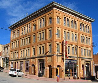
Cripple Creek is a statutory city that is the county seat of Teller County, Colorado, United States. The city population was 1,155 at the 2020 United States Census. Cripple Creek is a former gold mining camp located 20 miles (32 km) southwest of Colorado Springs near the base of Pikes Peak. The Cripple Creek Historic District, which received National Historic Landmark status in 1961, includes part or all of the city and the surrounding area. The city is now a part of the Colorado Springs, CO Metropolitan Statistical Area and the Front Range Urban Corridor.

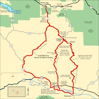
The Gold Belt Tour Scenic and Historic Byway is a National Scenic Byway, a Back Country Byway, and a Colorado Scenic and Historic Byway located in Fremont and Teller counties, Colorado, USA. The byway is named for the Gold Belt mining region. The Cripple Creek Historic District is a National Historic Landmark. The byway forms a three-legged loop with the Phantom Canyon Road, the Shelf Road, and the High Park Road (paved).

<span class="mw-page-title-main">Colorado Springs and Cripple Creek District Railway</span> United States historic place

The Colorado Springs and Cripple Creek District Railway was a 4 ft 8+12 instandard gauge railroad operating in the U.S. state of Colorado around the turn of the 20th century.

<span class="mw-page-title-main">Midland Terminal Railway</span>

The Midland Terminal Railway was a short line terminal railroad running from the Colorado Midland Railway near Divide to Cripple Creek, Colorado. The railroad made its last run in February 1949.

<span class="mw-page-title-main">Old Colorado City</span> Place in Colorado, United States

Old Colorado City, formerly Colorado City, was once a town, but it is now a neighborhood within the city of Colorado Springs, Colorado. Its commercial district was listed on the National Register of Historic Places in 1982. It was founded during the Pikes Peak Gold Rush of 1859 and was involved in the mining industry, both as a supply hub and as a gold ore processing center beginning in the 1890s. Residents of Colorado City worked at some of the 50 coal mines of the Colorado Springs area. It was briefly the capital of the Colorado Territory. For many years, Colorado Springs prohibited the use of alcohol within its border due to the lifestyle of Colorado City's opium dens, bordellos, and saloons. It is now a tourist area, with boutiques, art galleries, and restaurants.

<span class="mw-page-title-main">History of Colorado Springs, Colorado</span> Place in Colorado, United States

Before it was founded, the site of modern-day Colorado Springs, Colorado, was part of the American frontier. Old Colorado City, built in 1859 during the Pike's Peak Gold Rush was the Colorado Territory capital. The town of Colorado Springs was founded by General William Jackson Palmer as a resort town. Old Colorado City was annexed into Colorado Springs. Railroads brought tourists and visitors to the area from other parts of the United States and abroad. The city was noted for junctions for seven railways: Denver and Rio Grande (1870), Denver and New Orleans Manitou Branch (1882), Colorado Midland (1886-1918), Colorado Springs and Interurban, Atchison, Topeka, and Santa Fe (1889), Rock Island (1889), and Colorado Springs and Cripple Creek Railways. It was also known for mining exchanges and brokers for the Cripple Creek Gold Rush.

Gold mining in Colorado, a state of the United States, has been an industry since 1858. It also played a key role in the establishment of the state of Colorado.

Austin Bluffs is a summit in the Pikeview area of Colorado Springs in El Paso County, Colorado, at 6,673 feet (2,034 m) in elevation. It is also a residential area, that was once a settlement and the site of a tuberculosis sanatorium. The University of Colorado Colorado Springs campus was moved there in 1965. The summit also lends its name to a principal arterial road of the Colorado Springs area which traverses the southern and central sections of the corridor. It divides the Austin Bluffs open space from Palmer Park, and the Templeton Gap is located here as well.

<span class="mw-page-title-main">Mollie Kathleen Gold Mine</span>

The Mollie Kathleen Gold Mine is a historic vertical shaft mine near Cripple Creek, Colorado. The mine shaft descends 1,000 feet (300 m) into the mountain, a depth roughly equal to the height of the Empire State Building in New York City. The mine currently gives tours, and is visited by around 40,000 people annually. The addition of the mines and subsequent tours of this mine and others in the area had considerable effect on the economies of both Victor, Colorado and Cripple Creek.

<span class="mw-page-title-main">Cripple Creek & Victor Gold Mine</span>

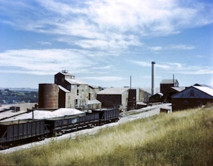
The Cripple Creek & Victor Gold Mine, formerly and historically the Cresson Mine, is an active gold mine located near the town of Victor, in the Cripple Creek mining district in the US state of Colorado. The richest gold mine in Colorado history, it is the only remaining significant producer of gold in the state, and produced 322,000 troy ounces of gold in 2019, and reported 3.45 million troy ounces of Proven and Probable Reserves as at December 31, 2019. It was owned and operated by AngloGold Ashanti through its subsidiary, the Cripple Creek & Victor Gold Mining Company (CC&V), until 2015, when it sold the mine to Newmont Mining Corporation.

<span class="mw-page-title-main">Palmer Park (Colorado Springs)</span>

Palmer Park is a regional park in Colorado Springs, Colorado. Located at 3650 Maizeland Road, the park is several miles northeast of the downtown area. Elevation Outdoors Magazine named it Best Urban Park in its Best of Rockies 2017 list. One of Best of the Springs Expert Picks - Sports & Recreation by The Gazette, Seth Boster states that it may have the city's best views of Pikes Peak and a place "where an escape into deep nature is easy. It is strange and marvelous to look out at urban sprawl while perched on some high rock ledge, surrounded by rugged wilderness."

Papeton, was a coal mining town, now in the area of Venetian Village, a neighborhood in Colorado Springs, Colorado, that is 1.4 miles (2.3 km) west southwest of Palmer Park. It is located at 6,184 feet (1,885 m) in elevation.

<span class="mw-page-title-main">Parks in Colorado Springs, Colorado</span>

There are a wide range of recreational areas and facilities in Colorado Springs, Colorado.

<span class="mw-page-title-main">Pikeview, Colorado</span>

Pikeview is a neighborhood of Colorado Springs, annexed to the city as the "Pike View Addition" on August 1, 1962. In 1896 there was a Denver and Rio Grande Western Railroad station in Pikeview, and miners had begun digging a shaft for the Pikeview Coal Mine. Pikeview also had a quarry beginning 1905 for the mining of limestone for concrete. Coal mining ended in 1957, but the Pikeview Quarry continues to operate. Quarry operations, though, have created a gash or scar in the landscape and efforts have been made since the late 1980s to reclaim the hillside landscape. The Greg Francis Bighorn Sheep Habitat in what had been Queens Canyon Quarry was founded in 2003 in recognition of the individuals and organizations that have worked to create a nature hillside habitat.

<span class="mw-page-title-main">Timeline of mining in Colorado</span>

Colorado mining history is a chronology of precious metal mining, fuel extraction, building material quarrying, and rare earth mining.

The Cripple Creek Gold Rush was a period of gold production in the Cripple Creek area from the late 1800s until the early 1900s. Mining exchanges were in Cripple Creek, Colorado Springs, Pueblo and Victor. Smelting was in Gillett, Florence, and (Old) Colorado City. Mining communities sprang up quickly, but most lasted only as long as gold continued to be produced. Settlements included:

St. Peter's Dome is a granite-topped peak on Pikes Peak massif in the Pike National Forest. The peak, at 9,528 feet (2,904 m) in elevation, is located in El Paso County, Colorado, above Colorado Springs. It is located about 8 miles (13 km) from Colorado Springs along Old Stage and Gold Camp Roads. Old Stage Road is picked up behind The Broadmoor and Gold Camp Road winds through Cheyenne Canyon.

<span class="mw-page-title-main">Golden Cycle Mining and Reduction Company</span>

Golden Cycle Mining and Reduction Company was a mining company in Colorado City in El Paso County, Colorado. The company was incorporated in West Virginia and was listed on the Colorado Springs Exchange. Albert E. Carlton was part owner of the Golden Cycle. Directors included Carlton, Spencer Penrose, Richard Roelofs, H. McGarry, L.G. Carlton, Bulkeley Wells.

<span class="mw-page-title-main">Cheyenne Mountain</span> Mountain in El Paso County, Colorado, US

Cheyenne Mountain is a triple-peaked mountain in El Paso County, Colorado, southwest of downtown Colorado Springs. The mountain serves as a host for military, communications, recreational, and residential functions. The underground operations center for the North American Aerospace Defense Command (NORAD) was built during the Cold War to monitor North American airspace for missile launches and Soviet military aircraft. Built deep within granite, it was designed to withstand the impact and fallout from a nuclear bomb. Its function broadened with the end of the Cold War, and then many of its functions were transferred to Peterson Air Force Base in 2006.

<span class="mw-page-title-main">Cragmor, Colorado</span> Area in Colorado, United States

Cragmor, first known as Cragmoor, is an area in northeastern Colorado Springs, Colorado, between Templeton Gap and Austin Bluffs. A coal mining site during the 19th century, the area became known as the Cragmor around the turn of the century because the Cragmor Sanitorium was located there. By the 1950s, the mines were abandoned and the land was developed for housing. Cragmor was annexed to the City of Colorado Springs in the early 1960s. The Cragmor Sanatorium became the main hall for the University of Colorado Colorado Springs campus.

References

  1. Sandra Dallas (January 1, 1988). Colorado Ghost Towns and Mining Camps. University of Oklahoma Press. p. 60. ISBN   978-0-8061-2084-3.
  2. Linda Duval; Marty Banks (August 2, 2011). Insiders' Guide® to Colorado Springs. Insider's Guide. p. 29. ISBN   978-0-7627-6936-0.
  3. Linda Duval; Marty Banks (August 2, 2011). Insiders' Guide® to Colorado Springs. Insider's Guide. p. 8. ISBN   978-0-7627-6936-0.
  4. Jerome C. Smiley, Semi-Centennial History of Colorado, (Chicago: Lewis, 1913) 267-268.
  5. 1 2 Linda Duval; Marty Banks (August 2, 2011). Insiders' Guide® to Colorado Springs. Insider's Guide. p. 10. ISBN   978-0-7627-6936-0.
  6. 1 2 "Cripple Creek and Colorado Springs". The Economist: A Weekly Financial, Commercial, and Real-estate Newspaper. Economist Publishing Company. August 18, 1900. p. 193.
  7. Linda Duval; Marty Banks (August 2, 2011). Insiders' Guide® to Colorado Springs. Insider's Guide. p. 25. ISBN   978-0-7627-6936-0.
  8. 1 2 Davant, Jeanne (July 24, 2001). "Rail developments kept area's progress on track". The Gazette. Colorado Springs, CO. Archived from the original on March 29, 2015. Retrieved February 18, 2015.
  9. 1 2 3 David Martinek, MDAD working committee (March 24, 2009). "A Short History of the Colorado Midland and Midland Terminal railroads" (PDF). Teller County, Colorado: Teller Historic and Environmental Coalition. Archived from the original (PDF) on February 18, 2015. Retrieved February 18, 2015.
  10. Tingvik, Linda Irene (December 30, 2006). "Rail dates". Cripple Creek Railroads. Archived from the original on February 11, 2012. Retrieved March 4, 2007.
  11. US-24 Bypass Upgrading Or Rerouting, Colorado Springs: Environmental Impact Statement. 1981. p. 13.
  12. Pike National Forest, Gold Camp Road Plan: Environmental Impact Statement. National Forest Service, US Department of Agriculture. 2005. pp. 3–36, 3–38.
  13. "A Look Back: Images from Colorado Springs' past". Colorado Springs Gazette. Retrieved May 8, 2017.
  14. Horace Jared Stevens; Walter Harvey Weed; Walter Garfield Neale; Lenox Hawes Rand; Edward Barney Sturgis; Joseph Zimmerman (1918). "Colorado: El Paso County". Mines Register: Successor to the Mines Handbook and the Copper Handbook. Mines Publications, Incorporated. p.  671.
  15. The Mines Handbook: An Enlargement of the Copper Hand Book; a Manual of the Mining Industry of North America. Stevens Copper Handbook Company. 1920. p. 603.
  16. Linda Duval; Marty Banks (August 2, 2011). Insiders' Guide® to Colorado Springs. Insider's Guide. p. 31. ISBN   978-0-7627-6936-0.
  17. Linda Duval; Marty Banks (August 2, 2011). Insiders' Guide® to Colorado Springs. Insider's Guide. pp. 32, 106. ISBN   978-0-7627-6936-0.
  18. Samuel Franklin Emmons (1927). Geology and Ore Deposits of the Leadville Mining District, Colorado. U.S. Government Printing Office. p. 117.
  19. 1 2 3 Stephen B. Roberts (2007). "Coal in the Front Range Urban Corridor—An Overview" (PDF). U.S. Geological Survey. p. 11. Retrieved May 7, 2017.PD-icon.svg This article incorporates text from this source, which is in the public domain .
  20. M.I. Goldman, M.I. (1910), The Colorado Springs coal field, Colorado: U.S. Geological Survey Bulletin 381, pp. 317–340
  21. Annual Report of the State Inspector of Coal Mines. Coal Mine Inspection Department of Colorado. 1922.
  22. 1 2 Johnson & Higgins; Schnabel Engineering Associates (March 21, 1988). "Cragmor Area Map, Colorado Springs Coal Field" (PDF). Mined Land Reclamation Division, State of Colorado. Retrieved May 5, 2017.
  23. 1 2 3 4 5 6 7 8 "Geologic Hazards (Colorado Springs)" (PDF). CIDBIMENA - Biblioteca Médica Nacional - UNAH. c. 1986. pp. 23–26. Retrieved May 5, 2017.
  24. "Rockrimmon / Pikeview mines (map)" (PDF). Colorado Geological Survey. May 8, 2017.
  25. 1 2 3 4 Jim Bates (March 29, 1979). "Cave-in Forces Evacuation" (PDF). Colorado Springs Sun. Retrieved May 5, 2017 via Pikes Peak Library District.
  26. "Colorado Springs Central (map)" (PDF). Colorado Geological Survey. May 8, 2017.
  27. Stephen B. Roberts (2007). "Coal in the Front Range Urban Corridor—An Overview" (PDF). U.S. Geological Survey. p. 40. Retrieved May 7, 2017.PD-icon.svg This article incorporates text from this source, which is in the public domain .
  28. "Geologic Hazards (Colorado Springs)" (PDF). CIDBIMENA - Biblioteca Médica Nacional - UNAH. c. 1986. p. 27. Retrieved May 5, 2017.
  29. R. Scott Rappold (April 3, 2008). "Geophone Will Be Called Upon To Find Old Mining Tunnels" (PDF). The Gazette. Retrieved May 9, 2017.
  30. "Geologic Hazards (Colorado Springs)" (PDF). CIDBIMENA - Biblioteca Médica Nacional - UNAH. c. 1986. p. 25. Retrieved May 5, 2017.
  31. "Geologic Hazards (Colorado Springs)" (PDF). CIDBIMENA - Biblioteca Médica Nacional - UNAH. c. 1986. pp. 27–28. Retrieved May 5, 2017.
  32. Bill Vogrin (September 27, 2012). "SIDE STREETS: Cragmor residents say UCCS students flunking civics lessons". The Gazette. Colorado Springs, Colorado. Retrieved May 5, 2017.
  33. Vogrin, Bill (September 27, 2012). "WHAT LIES BENEATH: Springs' coal-mining history leaves a maze of tunnels - and potential problems". The Gazette. Colorado Springs, Colorado.
  34. 1 2 Bill McKeown (August 2, 2003). "Scar start to heal: Damaged mountainside is well on its way to recovery thanks to hard work of dedicated leader, volunteers". The Gazette. Colorado Springs, Colorado. Archived from the original on March 25, 2016. Retrieved January 25, 2015.
  35. Charles William Henderson (1926). Mining in Colorado: a history of discovery, development and production. Washington, D.C.: Government Printing Office. p. 63.
  36. Dave Philipps (August 17, 2003). "Something in the water: Cheyenne Mountain colony united by common needs". The Gazette. Colorado Springs. Archived from the original on March 9, 2016. Retrieved January 31, 2015.
  37. "Cheyenne Mountain" (PDF). The Gazette. Colorado Springs. August 11, 1883. pp. 5:4, 8:1. Archived from the original (PDF) on February 2, 2015. Retrieved January 31, 2015.
  38. "Boom on Cheyenne Mountain" (PDF). The Gazette. Colorado Springs. November 17, 1883. pp. 2:6. Archived from the original (PDF) on February 2, 2015. Retrieved January 31, 2015.
  39. Pike National Forest, Gold Camp Road Plan: Environmental Impact Statement. National Forest Service, US Department of Agriculture. 2005. pp. 3–3, 3–30.
  40. Pike National Forest, Gold Camp Road Plan: Environmental Impact Statement. National Forest Service, US Department of Agriculture. 2005. pp. 3–30.
  41. "About". Western Museum of Mining & Industry.
  42. Zuckerman, Diane. "Mining museum reverberates with realistic settings". Denver Post.
  43. Don Laine; Barbara Laine; Eric Peterson (January 17, 2003). Frommer's Denver, Boulder and Colorado Springs. Wiley. p. 203. ISBN   978-0-7645-6732-2.

Further reading