Ivywild, Colorado

Last updated
Ivywild
Neighborhood
USA Colorado location map.svg
Red pog.svg
Ivywild
Ivywild on a map of Colorado
Coordinates: 38°48′38″N104°50′07″W / 38.81056°N 104.83528°W / 38.81056; -104.83528
CountryUnited States
StateColorado
MunicipalityColorado Springs
Founded byWilliam B. Jenkins
Time zone UTC−7 (MST)
  Summer (DST) UTC−6 (MDT)
Zip code
80905 [1]
Area code 719

Ivywild, Colorado, is a subdivision of Colorado Springs south of the downtown, west of Cascade Avenue and along Cheyenne Creek. [2] As of 2015, the United States Geological Survey defines Ivywild as a Populated Place. [3] It is one of the city's oldest working-class neighborhoods. [4]

Contents

Early history

Before Europeans settled in the area, Cheyenne set up tepees at the confluence of the Fountain and Cheyenne Creeks when they traveled through the area. About 1859, Irving Howbert and his family settled near the creeks. [5] The following year, John Wolfe settled along Cheyenne Creek. [6] The area was called Ivywild by 1879. [7]

William B. Jenkins.jpg Anne Maria Iles Jenkins.jpg
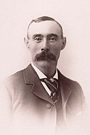
William B. Jenkins
(1848-1917)
Anne Maria Iles Jenkins
(1861-1940)

Ivywild was established in 1888 and platted by William B. Jenkins, a rancher and miner, who created 43 lots when he subdivided his ranch. His wife Annie named the town. [5] [8] She was a large stockholder of Ramona Mining Company. Her father, William Iles, was the Manager of Manitou Springs' first hotel, La Font. [9] Ivywild had a post office by January 1892. [10]

The Ivywild Improvement Society held annual meetings by 1898, when they discussed the high water rates and taxes. [11] [lower-alpha 1] The organization filed suits in 1917 regarding public utility service to the community. [14] Dorchester Park was named for Joseph Dorr, a water rights attorney, who established water rights for Cheyenne Canon and Ivywild. The Iowa native operated a hay farm after having settled in the area in 1874. The park is located across the creek from the site of Dorr's farm. [5]

John H. Bacon, a mayor of Colorado Springs in 1880, lived in Ivywild by 1900. [15] [16] [lower-alpha 2]

Early 20th century

The Ivywild Elementary School was founded in 1901 with two bungalow buildings until 1916 when a brick building was constructed. The two bungalows were moved, one became the Edelweiss Restaurant and the other the Ivywild Presbyterian Church. [18]

In 1902, Winfield Scott Stratton (1848-1902) and Thomas F. Burns purchased 10 acres along Cheyenne Boulevard from William B. Jenkins for $16,000 (equivalent to $541,169in 2022). The equal partners purchased the land for the construction of baseball park called Boulevard Park, [19] just west of Jenkins Pond (now Tejon Street and Cheyenne Boulevard). [20] The base ball park was built by Statton, [21] but not completed until after his death. [22] The Burns brothers (James and Thomas Burns) bought The Millionaires baseball club, and Thomas F. Burns was president of the club. [23] The Colorado Springs Millionaires baseball team played at the park, often known as Base Ball Park, that sat 3,500 people. [20] Boulevard Park, on the Colorado Springs and Interurban Railway's electric trolley route, [22] was about a 5-minute trolley ride from the center of town. [20]

Residents of Ivywild met at Jenkins' house on South Nevada Avenue to discuss the creation of a local government in 1902, when the community was governed by El Paso County, Colorado. It was reported that the time was right because "the growth of the pretty suburb has been steady." [24] Plans were made later that year to begin to incorporate the town. [25]

John Coughlin, a ward boss from Chicago, bought property in 1903 to invest in Ivywild development. [26] He donated a carriage with fire equipment to the town in 1904. [27] Coughlin built an amusement park, Cheyenne Springs Park and Zoo, at Alsace Way and 8th Street in 1906 at the cost of $75,000 (equivalent to $2,442,778in 2022). [5] [28] A play entitled, Ivywild: The True Story of John "Bathhouse" Coughlin has been written about the man. [5]

Charles Maddocks, who built houses in Ivywild from wood salvaged from Nikola Tesla's laboratory, bought Boulevard Park in 1904 when the Millionaires dissolved. He built bungalows, including Sears and other mail order homes. [5] The Ivywild Pharmacy and Ivywild Grocery and Market were both doing business by 1916. [29]

Annexation and current status

In 1960, Ivywild had 10,608 residents and was part of the 17,713 population of Cheyenne Mountain Division, was a census county division in El Paso County, Colorado. [30] In 1977, residents voted not to create a village called Cheyenne Mountain by consolidating the towns of Broadmoor, Skyway, Cheyenne Canon, and Ivywild. [31]

A General Assembly bill in 1978 proposed consolidation of the suburbs into Colorado Springs. [32] Ivywild was one of five Colorado Springs suburbs annexed into Colorado Springs in 1980. The others were Broadmoor, Skyway, Cheyenne Canon, and Stratton Meadows. The annexation added 6.5 square miles (17 km2) and 20,000 people to the city's total area and population. The Colorado Supreme Court upheld the annexation in 1982. [33]

Ivywild School mixed-use center

The Ivywild Elementary School and Ivywild Community Church closed in 2009. [2] The former elementary school was made into a multi-use commercial and community center called Ivywild School in 2013. The remodeled 20,000 square feet (1,900 m2) building has a delicatessen, brewery, pub, bakery, coffee shop, gift shop, and architectural office. The project was partially funded by the city under an urban renewal project. [18]

Park

Ivywild Park, located at Navajo and Dorchester, was dedicated in 2005. The funding for the only neighborhood park in Ivywild was provided by a federal grant. [34] [4]

Notable people

Notes

  1. In 1914, The Gazette reported that an improvement society was to be created for Ivywild to be properly prepared to manage a fire. [12] The Gazette reported in 2007 that the Ivywild Improvement Society was founded in 1915. [13]
  2. Bacon committed suicide at his Ivywild house in January 1904 at 70 years of age. He had been suffering from poor physical and mental health. [17]

Related Research Articles

<span class="mw-page-title-main">Colorado Springs, Colorado</span> City in Colorado, United States

Colorado Springs is a home rule municipality in and the county seat of El Paso County, Colorado, United States. It is the largest city in El Paso County, with a population of 478,961 at the 2020 United States Census, a 15.02% increase since 2010. Colorado Springs is the second-most populous city and the most extensive city in the state of Colorado, and the 40th-most populous city in the United States. It is the principal city of the Colorado Springs metropolitan area and the second-most prominent city of the Front Range Urban Corridor. It is located in east-central Colorado, on Fountain Creek, 70 miles (113 km) south of Denver.

<span class="mw-page-title-main">El Paso County, Colorado</span> County in Colorado, United States

El Paso County is the most populous county located in the U.S. state of Colorado. The 2020 Census recorded its population as 730,395, surpassing the City and County of Denver. The county seat is Colorado Springs, the second most populous city in Colorado. El Paso County is included in the Colorado Springs, Colorado, Metropolitan Statistical Area and is located in Colorado's 5th congressional district, except for the far eastern extremities, which are located in the 4th.

<span class="mw-page-title-main">Manitou Springs, Colorado</span> City in Colorado, United States

Manitou Springs is a home rule municipality located at the foot of Pikes Peak in western El Paso County, Colorado, United States. The town was founded for its natural mineral springs. The downtown area continues to be of interest to travelers, particularly in the summer, with many shops and restaurants, as well as a creekside city park. The main road through the center of town was one of the direct paths to the base of Pikes Peak. Barr Trail, which winds its way up Pikes Peak, is accessible from town. The subdivision Crystal Hills was added to the municipality in the 1960s.

<span class="mw-page-title-main">Cascade, Colorado</span> Unincorporated community in State of Colorado, United States

Cascade is an unincorporated community and U.S. Post Office in El Paso County, Colorado, United States. The ZIP Code of the Cascade Post Office is 80809.

<span class="mw-page-title-main">History of Colorado Springs, Colorado</span> Place in Colorado, United States

Before it was founded, the site of modern-day Colorado Springs, Colorado, was part of the American frontier. Old Colorado City, built in 1859 during the Pike's Peak Gold Rush was the Colorado Territory capital. The town of Colorado Springs was founded by General William Jackson Palmer as a resort town. Old Colorado City was annexed into Colorado Springs. Railroads brought tourists and visitors to the area from other parts of the United States and abroad. The city was noted for junctions for seven railways: Denver and Rio Grande (1870), Denver and New Orleans Manitou Branch (1882), Colorado Midland (1886-1918), Colorado Springs and Interurban, Atchison, Topeka, and Santa Fe (1889), Rock Island (1889), and Colorado Springs and Cripple Creek Railways. It was also known for mining exchanges and brokers for the Cripple Creek Gold Rush.

<span class="mw-page-title-main">Palmer Park (Colorado Springs)</span>

Palmer Park is a regional park in Colorado Springs, Colorado. Located at 3650 Maizeland Road, the park is several miles northeast of the downtown area. Elevation Outdoors Magazine named it Best Urban Park in its Best of Rockies 2017 list. One of Best of the Springs Expert Picks - Sports & Recreation by The Gazette, Seth Boster states that it may have the city's best views of Pikes Peak and a place "where an escape into deep nature is easy. It is strange and marvelous to look out at urban sprawl while perched on some high rock ledge, surrounded by rugged wilderness."

Papeton, was a coal mining town, now in the area of Venetian Village, a neighborhood in Colorado Springs, Colorado, that is 1.4 miles (2.3 km) west southwest of Palmer Park. It is located at 6,184 feet (1,885 m) in elevation.

<span class="mw-page-title-main">Cheyenne Mountain Highway</span> Road in Colorado Springs, Colorado

The Cheyenne Mountain Highway, also called Cheyenne Mountain Zoo Road, is a road in Colorado Springs, Colorado that begins at the intersection of Penrose Boulevard, Old Stage Road, and West Cheyenne Mountain Boulevard. It is a paved road to the Cheyenne Mountain Zoo and the Will Rogers Shrine of the Sun. Thereafter, it is an unpaved private road to one of the peaks of the mountain, known as The Horns.

<span class="mw-page-title-main">Parks in Colorado Springs, Colorado</span>

There are a wide range of recreational areas and facilities in Colorado Springs, Colorado.

<span class="mw-page-title-main">Colorado Springs Pioneers Museum</span> United States historic place

The Colorado Springs Pioneers Museum is located at 215 S. Tejon Street in Colorado Springs, Colorado. The granite building with a domed clock tower was the El Paso County Courthouse building from 1903 to 1973. The museum, which moved to this location in 1979, has fine arts, artifacts and archival collections that document the Pikes Peak region. The building is on the National Register of Historic Places, and was the 2nd property to be listed in El Paso County, after Pikes Peak.

<span class="mw-page-title-main">Broadmoor, Colorado</span> Neighborhood of Colorado Springs, Colorado

Broadmoor is a neighborhood in Colorado Springs, Colorado.

<span class="mw-page-title-main">Colorado Springs and Interurban Railway</span>

The Colorado Springs and Interurban Railway was an electric trolley system in the Colorado Springs, Colorado that operated from 1902 to 1932. The company was formed when Winfield Scott Stratton purchased Colorado Springs Rapid Transit Railway in 1901 and consolidated it in 1902 with the Colorado Springs & Suburban Railway Company. It operated in Colorado Springs, its suburbs, and Manitou Springs. One of the street cars from Stratton's first order is listed on the Colorado State Register of Historic Properties.

<span class="mw-page-title-main">South Cheyenne Cañon</span> Canyon in Colorado Springs, Colorado

South Cheyenne Cañon, or South Cheyenne Canyon, is a canyon in Colorado Springs, El Paso County, Colorado. The South Cheyenne Cañon road to Seven Falls is called "The Grandest Mile of Scenery" in Colorado. Seven Falls has been a tourist attraction since it was opened in the early 1880s. Trails from the top of the falls lead to Midnight Falls, near the headwaters of South Cheyenne Creek, and Inspiration Point. The area has been a center for parks, such as the Stratton Park and Colorado College Park. Now, part of South Cheyenne Cañon, including the Starsmore Discovery Center, is in the North Cheyenne Cañon Park. The area sustained a significant flood in September 2013, which closed Seven Falls until Spring 2015. Presently the falls are open again.

The following is a timeline of the history of the city of Colorado Springs, Colorado, USA.

<span class="mw-page-title-main">Seven Lakes, Colorado</span>

Seven Lakes is an abandoned, historically populated place in Teller County, Colorado, on the Pikes Peak mountain. It was once the site of the Seven Lakes Hotel along a carriage road to the summit of Pikes Peak. Its waters flow from Beaver Creek to the Lake Moraine reservoir, a supplier of water to Colorado Springs.

<span class="mw-page-title-main">Cheyenne Creek</span>

Cheyenne Creek is a stream in Colorado Springs, El Paso County, Colorado at 5,920 feet (1,800 m) in elevation. The stream is fed by the North Cheyenne Creek and South Cheyenne Creek and flows into Fountain Creek near Nevada Avenue, between Interstate 25 and the Pikes Peak Greenway trail. North Cheyenne Creek and South Cheyenne Creek flow through Teller and El Paso Counties. The source of South Cheyenne Creek is Mount Big Chief, near St. Peter's Dome, and it flows to Seven Falls.

<span class="mw-page-title-main">Cheyenne Mountain</span> Mountain in El Paso County, Colorado, US

Cheyenne Mountain is a triple-peaked mountain in El Paso County, Colorado, southwest of downtown Colorado Springs. The mountain serves as a host for military, communications, recreational, and residential functions. The underground operations center for the North American Aerospace Defense Command (NORAD) was built during the Cold War to monitor North American airspace for missile launches and Soviet military aircraft. Built deep within granite, it was designed to withstand the impact and fallout from a nuclear bomb. Its function broadened with the end of the Cold War, and then many of its functions were transferred to Peterson Air Force Base in 2006.

<span class="mw-page-title-main">Cragmor, Colorado</span> Area in Colorado, United States

Cragmor, first known as Cragmoor, is an area in northeastern Colorado Springs, Colorado, between Templeton Gap and Austin Bluffs. A coal mining site during the 19th century, the area became known as the Cragmor around the turn of the century because the Cragmor Sanitorium was located there. By the 1950s, the mines were abandoned and the land was developed for housing. Cragmor was annexed to the City of Colorado Springs in the early 1960s. The Cragmor Sanatorium became the main hall for the University of Colorado Colorado Springs campus.

In the mid-19th century, Colorado Springs was a center of mining industry activity. Coal was mined in 50 mines in the area and towns, now annexed to Colorado Springs, were established to support residents of the coal mining industry.

<span class="mw-page-title-main">Edgerton, Colorado</span>

Edgerton is an extinct town at the confluence of Monument Creek and West Monument Creek eight miles north of present-day Colorado Springs in El Paso County, Colorado, United States. and. It was across from Black Forest. The Edgerton post office operated from June 16, 1870, until August 28, 1902.

References

  1. "Colorado Springs Zip Code Map". zipmap.net. Retrieved May 7, 2017.
  2. 1 2 Bill Vogrin (September 28, 2009). "Resident recalls a gentler Ivywild". The Gazette. Colorado Springs, Colorado. Archived from the original on March 8, 2016. Retrieved January 25, 2015.
  3. "GNIS Detail - Ivywild". geonames.usgs.gov. Retrieved May 19, 2020.
  4. 1 2 "Briefly Metro". The Gazette. Colorado Springs, Colorado. October 14, 2005. Archived from the original on November 17, 2018. Retrieved January 25, 2015.
  5. 1 2 3 4 5 6 Bill Vogrin (January 11, 2015). "Ivywild comes alive thanks to two women" (PDF). The Gazette. p. 23. Archived from the original (PDF) on March 5, 2016. Retrieved January 25, 2015 via Pikes Peak Library District.
  6. "John Wolfe, Early Settler, Is Dead" (PDF). The Gazette. August 10, 1909. p. 5:5. Archived from the original (PDF) on March 5, 2016. Retrieved January 25, 2015 via Pikes Peak Library District.
  7. "Wildcat killed in Ivywild". The Gazette. Colorado Springs, Colorado. November 15, 1879.
  8. William Bright (2004). Colorado Place Names. Big Earth Publishing. p. 93. ISBN   978-1-55566-333-9.
  9. "Mrs. Annie H. Jenkins, Widow of Founder of Ivywild, Dies in Westcliffe; Funeral Here" (PDF). The Gazette. Colorado Springs. July 24, 1940. p. 1:6. Retrieved January 25, 2015 via Pikes Peak Library District.
  10. United States Official Postal Guide. U.S. Government Printing Office. January 1892. p. 509.
  11. "Ivywild Improvement" (PDF). The Weekly Gazette. March 15, 1898. p. 3-2. Retrieved January 25, 2015 via Pikes Peak Library District.
  12. "Ivywild Citizens Seek Projection Against Fire" (PDF). The Weekly Gazette. March 1, 1914. p. 5-2. Retrieved January 25, 2015 via Pikes Peak Library District.
  13. Bill Vogrin (January 4, 2007). "Archivist hopes to document modern Springs for the future". The Gazette. Colorado Springs, Colorado. Archived from the original on March 29, 2015. Retrieved January 25, 2015.
  14. Colorado Public Utilities Commission (1917). Annual Report. pp. 33, 49.
  15. "Col. Bacon's residence, Cheyenne Canon, Colorado Springs". Denver Public Library. Retrieved January 25, 2015.
  16. Colorado Springs City Council; John R. Robinson (1902). Town incorporation, city organization and reorganization, also classification as city of the first class. City Council. p. 185.
  17. "John H. Bacon A Suicide: Wealthy Resident of Colorado Springs Takes His Own Life" (PDF). The New York Herald. January 18, 1904. p. 7. Retrieved January 25, 2015.
  18. 1 2 Rich Laden (August 16, 2013). "Colorado Springs' Ivywild School Celebrates New Life as a Mixed-Use Commercial Center". The Gazette. Colorado Springs, Colorado.[ dead link ]
  19. "Stratton and Burns - Buy Boulevard Park". The Weekly Gazette. Colorado Springs. March 13, 1902. p. 11. Retrieved January 25, 2015.
  20. 1 2 3 Dennis Pajot (29 August 2011). Baseball's Heartland War, 1902-1903: The Western League and American Association Vie for Turf, Players and Profits. McFarland. pp. 63–64. ISBN   978-0-7864-8904-6.
  21. Hadix, Roger P. (2013). Baseball in Colorado Springs. Arcadia Publishing. p. 29. ISBN   978-0-7385-9954-0.
  22. 1 2 Allan C. Lewis (2006). Railroads of the Pike's Peak Region, 1900-1930. Arcadia Publishing. p. 95. ISBN   978-0-7385-3125-0.
  23. Hadix, Roger P. (2013). Baseball in Colorado Springs. Arcadia Publishing. pp. 29, 38. ISBN   978-0-7385-9954-0.
  24. "A Town Government is Proposed for Ivywild". The Weekly Gazette. Colorado Springs. March 20, 1902. p. 11. Retrieved January 25, 2015.
  25. "Will Incorporate Town of Ivywild" (PDF). The Weekly Gazette. Colorado Springs. November 20, 1902. p. 5:1. Retrieved January 25, 2015.
  26. "Johnson Tract in Ivywild Will Become New Chicago" (PDF). The Gazette. January 4, 1903. pp. 1–5. Retrieved January 25, 2015 via Pikes Peak Library District.
  27. "Ivywild Gets Fire Apparatus" (PDF). The Gazette. July 24, 1904. p. 5-2. Retrieved January 25, 2015 via Pikes Peak Library District.
  28. "Coney Island Resort in Ivywild to Cost $75,000" (PDF). The Gazette. January 5, 1906. p. 1-1. Retrieved January 25, 2015 via Pikes Peak Library District.
  29. Colorado. Bureau of Labor Statistics (1916). "El Paso County - Mercantile Lists". Biennial Report. The Bureau. p. 112.
  30. "Number of Inhabitants - Colorado" (PDF). Table 7. Population of Counties, By Census County Divisions: 1960. US Census Bureau, US Government Printing Office. p. 7-1, 7-16 (map). Retrieved January 25, 2015.
  31. "Consolidation of four suburbs". Western History. Denver Public Library. November 16, 1977. Retrieved January 25, 2015.
  32. "Consolidation of four suburbs: Analysis of General Assembly Bill". Western History. Denver Public Library. January 22, 1978. Retrieved January 25, 2015.
  33. Bill Vogrin (May 20, 2007). "Annexation -- an issue that doesn't go away". The Gazette. Colorado Springs, Colorado. Archived from the original on September 24, 2015. Retrieved January 25, 2015.
  34. Ed Sealover (December 26, 2004). "After struggle, Ivywild gets place to play Community park is ready to build after 11 years". The Gazette. Colorado Springs, Colorado. Archived from the original on April 9, 2016. Retrieved January 25, 2015.
  35. David Roberts (31 December 2003). Jean Stafford. St. Martin's Press. p. 23. ISBN   978-0-312-30217-7.

Further reading

External images
Searchtool.svg Images of Colonel John H. Bacon's Ivywild property (1890-1900), Denver Public Library
Searchtool.svg Colorado Midland Railway engine and cars through Ivywild, Pikes Peak Library District
Searchtool.svg Ivywild after the May 1935 flood, Pikes Peak Library District
Searchtool.svg South entrance to Colorado Springs, Ivywild sign in lower left (1965), Pikes Peak Library District

U.S. Geological Survey Geographic Names Information System: Ivywild, Colorado