Miramar, New Zealand

Last updated

Miramar
Roxy, Miramar, Wellington (8489576892).jpg
Roxy Cinema in Miramar
Miramar, New Zealand
Wellington, New Zealand map.svg
Disc Plain red.svg
Miramar
Coordinates: 41°19′S174°49′E / 41.317°S 174.817°E / -41.317; 174.817
CountryNew Zealand
City Wellington City
Local authority Wellington City Council
Electoral ward
  • Motukairangi/Eastern Ward
  • Te Whanganui-a-Tara Māori Ward
Established1904
Area
[1]
  Land287 ha (709 acres)
Population
 (June 2023) [2]
  Total10,030
Maupuia Karaka Bays
Kilbirnie
Pfeil oben.svg
Pfeil links.svgMiramarPfeil rechts.svg
Pfeil unten.svg
Worser Bay
Rongotai Strathmore Park Seatoun

Miramar is a suburb of Wellington, New Zealand, south-east of the city centre. It is on the Miramar Peninsula, directly east of the isthmus of Rongotai, the site of Wellington International Airport.

Contents

History

See Miramar Peninsula for an extended history of the whole island/peninsula.

The original Māori name for the area when it was still an island was Te Motu Kairangi (meaning "esteemed" or "precious" island). [3] The island is now a peninsula, but was separated from the main island by a sea channel called Te Awa-a-Taia [4] (the channel of Taia); this was where Kilbirnie is now.

The island of Te Motu Kairangi was first settled as long ago as 950 when Kupe the explorer arrived. The area was home in turn to Ngai Tara, Rangitane, Ngati Kahungungu, Ngai Tahu, Mua Upoko, Ngati Ira, and Te Ati Awa. [5] [ page needed ] Kupe first landed near Seatoun, and a large rock near the shore still bears the name Te Ure-o-Kupe (Kupe’s penis) or Te Aroaro-o-Kupe (Kupe’s presence) [6]

Ngai Tara were the first to settle here, [7] [8] and built the first pa, named "Whetu Kairangi" on the hill overlooking Worser bay. [5] [ page needed ] The name of Wellington harbour "Whanganui-a-Tara" (harbour of Tara) was also named for Tara. [7]

'Miramar' means "sea view" in Spanish. The name was chosen by the first European to settle in the area, Scotsman Coutts Crawford (1817–1889). Crawford was a former Royal Navy officer turned businessman and colonist, who arrived in Wellington in 1840. Crawford established a farm on the peninsula, which at the time was known as Watt's Peninsula, and drained a large lagoon known as Burnham Water. This lagoon covered much of the low-lying land on the peninsula; now this area is occupied by suburban houses, streets, parks and shops.

On 18 November 1904 Miramar Borough was formed. [9] In April 1921, Miramar was incorporated into the City of Wellington. [10] The records of the Miramar Borough Council were transferred to the City of Wellington at the time of amalgamation and can still be accessed today through Wellington City Council. [11]

Demographics

Miramar, comprising the statistical areas of Miramar North, Miramar Central, Miramar East and Miramar South, covers 2.87 km2 (1.11 sq mi). [1] It had an estimated population of 10,030 as of June 2023, with a population density of 3,495 people per km2.

Historical population
YearPop.±% p.a.
20069,210    
20139,486+0.42%
20189,831+0.72%
Source: [12]

Before the 2023 census, Miramar had a slightly different boundary, covering 2.87 km2 (1.11 sq mi). [1] Using that boundary, Miramar had a population of 9,831 at the 2018 New Zealand census, an increase of 345 people (3.6%) since the 2013 census, and an increase of 621 people (6.7%) since the 2006 census. There were 3,585 households, comprising 4,851 males and 4,989 females, giving a sex ratio of 0.97 males per female, with 1,881 people (19.1%) aged under 15 years, 1,770 (18.0%) aged 15 to 29, 4,794 (48.8%) aged 30 to 64, and 1,389 (14.1%) aged 65 or older.

Ethnicities were 66.6% European/Pākehā, 8.6% Māori, 9.3% Pasifika, 20.7% Asian, and 6.3% other ethnicities. People may identify with more than one ethnicity.

The percentage of people born overseas was 32.9, compared with 27.1% nationally.

Although some people chose not to answer the census's question about religious affiliation, 44.6% had no religion, 37.4% were Christian, 0.4% had Māori religious beliefs, 5.7% were Hindu, 1.4% were Muslim, 2.8% were Buddhist and 1.8% had other religions.

Of those at least 15 years old, 2,475 (31.1%) people had a bachelor's or higher degree, and 1,206 (15.2%) people had no formal qualifications. 1,938 people (24.4%) earned over $70,000 compared to 17.2% nationally. The employment status of those at least 15 was that 4,302 (54.1%) people were employed full-time, 1,071 (13.5%) were part-time, and 282 (3.5%) were unemployed. [12]

Individual statistical areas in 2018
NameArea
(km2)
PopulationDensity
(per km2)
HouseholdsMedian ageMedian
income
Miramar North0.511,3472,64146536.8 years$34,000 [13]
Miramar Central0.531,9713,71978339.8 years$32,300 [14]
Miramar East0.853,0033,5331,08038.9 years$47,300 [15]
Miramar South0.983,5103,5821,25738.1 years$36,600 [16]
New Zealand37.4 years$31,800

Film

Prior to World War II in 1936 the then government purchased an independent film company called Filmcraft in Darlington Rd, Miramar and set up a full body, government film production operation, to cover New Zealand's contribution in the war (and the 1940 Centennial celebrations). It was called the National Film Unit. [17] In 1979 the NFU moved to Avalon, Lower Hutt, next to the national television entity Avalon Studios . In the late nineties, film director Sir Peter Jackson purchased the Film Unit, as it was then known, to produce his films. He used the NFU's facilities while making Braindead . Since then, Jackson has brought the Film Unit back to Miramar, which would now be seen as a sunset arm of his empire.[ citation needed ]

Jackson and his colleagues Sir Richard Taylor (VFX) and Jamie Selkirk (Editor) have built a series of multi million-dollar studios, sound stages, and pre- and post-production facilities in Miramar that include Stone Street Studios, Park Road Post, Weta Digital, and Weta Workshop. Jackson filmed the studio scenes of The Lord of the Rings trilogy and King Kong in Miramar. Miramar has been hailed by Mexican film director Guillermo del Toro as "Hollywood the way God intended it". [18]

Roxy Cinema

The Roxy Cinema building at the Miramar shopping centre in Park Road was built by local businessman Sidney Morrison, and opened as Capitol Theatre in January 1929. [19] The Capitol closed in 1964 and the building then became the Capitol Court shopping plaza. After lying abandoned for many years, the building was bought by Camperdown Studios Group in 2003. [20] [21] The façade was retained but the rest of the building was demolished and rebuilt as a two-screen movie theatre, opening in 2011. [22] [23] As of 2022 the Roxy was owned by Jamie Selkirk and his wife Ann, Weta Workshop founder Tania Rodger, local foodie Valentina Dias, Daminda Dias, and renowned bartender and cocktail master Ray Letoa. [22] The interior of the building is designed in a lush 1930s style. The upstairs lobby features a large ceiling mural by Greg Broadmore of Weta Workshop, which was inspired by the film Metropolis. [24] An Oscar won by Jamie Selkirk was on display in the theatre, [24] and a statue of Gandalf stands in front of the building.

Education

State primary schools

Miramar Central School is a co-educational state primary school for Year 1 to 6 students, [25] with a roll of 165 as of February 2024. [26]

Miramar North School is also a co-educational state primary school for Year 1 to 6 students, [27] [28] with a roll of 248. [29]

Christian primary schools

Holy Cross School is a co-educational state-integrated Catholic primary school for Year 1 to 8 students, [30] with a roll of 155. [31]

Miramar Christian School is a co-educational state primary school for Year 1 to 8 students, [32] [33] with a roll of 38. [34]

Early Childhood Education

There are a number of early childhood educational facilities in Miramar, including Miramar North Kindergarten, Miramar Central Kindergarten, Tuatara Kids, Kidz Corner, and Montessori Children's House.

Related Research Articles

<span class="mw-page-title-main">Matamata</span> Town in Waikato, New Zealand

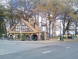
Matamata is a town in Waikato, New Zealand. It is located near the base of the Kaimai Ranges, and is a thriving farming area known for Thoroughbred horse breeding and training pursuits. It is part of the Matamata-Piako District, which takes in the surrounding rural areas, as well as Morrinsville and Te Aroha. State Highway 27 and the Kinleith Branch railway run through the town. The town has a population of 9,130 as of June 2023.

<span class="mw-page-title-main">Trentham, New Zealand</span> Suburb of Upper Hutt City, New Zealand

Trentham is the most populous suburb of Upper Hutt, a city in the Wellington region of New Zealand. The suburb is located in a widening of the Hutt Valley, five kilometres to the southwest of the Upper Hutt city centre.

<span class="mw-page-title-main">Wellington Harbour</span> Harbour in New Zealand

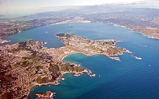
Wellington Harbour, officially called Wellington Harbour / Port Nicholson, is a large natural harbour on the southern tip of New Zealand's North Island. The harbour entrance is from Cook Strait. Central Wellington is located on parts of the western and southern sides of the harbour, and the suburban area of Lower Hutt is to the north and east.

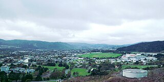
Tokoroa is the fifth-largest town in the Waikato region of the North Island of New Zealand and largest settlement in the South Waikato District. Located 30 km southwest of Rotorua and 20 km south of Putāruru, close to the foot of the Mamaku Ranges, it is midway between Taupō and Hamilton on State Highway 1.

<span class="mw-page-title-main">Mount Victoria (Wellington suburb)</span> Suburb of Wellington City, New Zealand

Mount Victoria is a suburb of central Wellington, New Zealand, named after the 196 metres (643 ft) hill Mount Victoria to the east. Mount Victoria's residential area is on its north-western slopes.

<span class="mw-page-title-main">Miramar Peninsula</span> Land in Wellington city, New Zealand

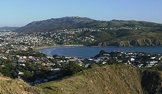
Te Motu Kairangi / Miramar Peninsula is a large peninsula on the southeastern side of the city of Wellington, New Zealand. It is located at the entrance to Wellington Harbour, in Wellington's eastern suburbs. According to Māori legend, it was formed when the taniwha Whaitaitai beached as he tried to escape the confines of the harbour. It contains the suburbs of Miramar, Seatoun, Strathmore Park, and Karaka Bays.

<span class="mw-page-title-main">Ruatāhuna</span> Place in Bay of Plenty, New Zealand

Ruatāhuna is a small town in the remote country of Te Urewera, in the northeast of New Zealand's North Island. It is 90 kilometres directly west of Gisborne, and 18 kilometres northwest of Lake Waikaremoana. By road, it is 50 kilometres south-east of Murupara, and 110 kilometres north-west of Wairoa. It is on the upper reaches of the Whakatāne River, and surrounded on three sides by the Te Urewera protected area, formerly the Te Urewera National Park. The road that runs from Murupara through Ruatahuna to Āniwaniwa on Lake Waikaremoana, a large part of which is unsealed, used to be designated as part of State Highway 38. It is a subdivision of the Galatea-Murupara ward of the Whakatāne District.

<span class="mw-page-title-main">Papamoa</span> Suburb of Tauranga, New Zealand

Papamoa or Papamoa Beach is a suburb of Tauranga, located about 11 kilometres from the city centre. It is the largest residential suburb in Tauranga. It is bordered to the west by Arataki and Mount Maunganui, the east by the Kaituna River and to the south by State Highway 2.

<span class="mw-page-title-main">Ōtaki, New Zealand</span> Settlement in Wellington Region, New Zealand

Ōtaki is a town in the Kāpiti Coast District of the North Island of New Zealand, situated half way between the capital city Wellington, 70 km (43 mi) to the southwest, and Palmerston North, 70 km (43 mi) to the northeast.

<span class="mw-page-title-main">Island Bay</span> Suburb of Wellington City, New Zealand

Island Bay is a coastal suburb of Wellington, the capital of New Zealand, situated 5 km (3.1 mi) south of the city centre.

<span class="mw-page-title-main">Hataitai</span> Suburb of Wellington City, New Zealand

Hataitai is an inner-city suburb of Wellington, the capital of New Zealand, 3.5 kilometres southeast of the city centre. The suburb extends over the southeastern flank of Mount Victoria and down a valley between the Town Belt and a ridge along the shoreline of Evans Bay. Hataitai is bounded by Hepara Street, Grafton Road and the suburb of Roseneath in the north, Wellington Harbour in the east, Cobham Drive, Wellington Road and Crawford Road in the south, and Alexandra Road in the west.

<span class="mw-page-title-main">Seatoun</span> Suburb of Wellington City, New Zealand

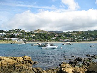
Seatoun, an eastern suburb of Wellington, the capital city of New Zealand, lies on the east coast of the Miramar Peninsula, close to the entrance to Wellington Harbour, some seven kilometres southeast of the CBD. The suburb sits on an exposed promontory close to Barrett Reef, a dangerous area of rocky shallows upon which many ships have foundered, most notably the inter-island ferry TEV Wahine in 1968.

<span class="mw-page-title-main">Tītahi Bay</span> Suburb of Porirua

Tītahi Bay is a suburb of Porirua in metropolitan Wellington, in the lower North Island of New Zealand. It lies at the foot of a short peninsula on the west coast of the Porirua Harbour, to the north of Porirua city centre.

Heretaunga is a suburb of the city of Upper Hutt, located in the lower (southern) North Island of New Zealand. The settlement, one of the older suburbs in the Hutt Valley, dates from the 1840s when European settlers sought country sections. A prime example of a "leafy" suburb, Heretaunga includes quiet tree-lined streets. It is characterised by large houses, often Edwardian or from the mid-20th century.

<span class="mw-page-title-main">Rongotai</span> Suburb of Wellington City, New Zealand

Rongotai is a suburb of Wellington, New Zealand, located southeast of the city centre. It is on the Rongotai isthmus, between the Miramar Peninsula and the suburbs of Kilbirnie and Lyall Bay. It is known mostly for being the location of the Wellington International Airport. It is roughly in the centre of the Rongotai electorate, which is much bigger than the suburb.

Waitangirua is a suburb of Porirua City approximately 22km north of Wellington in New Zealand.

Te Hapara is a suburb of the New Zealand city of Gisborne. It is located in the northwest of the city. It contains one primary school, Te Hapara School, which is located in Mill Road.

Pyes Pa is a suburb of Tauranga, New Zealand.

<span class="mw-page-title-main">Strathmore Park</span> Suburb of Wellington City, New Zealand

Strathmore Park is a suburb of Wellington City, New Zealand. It is located at the southern end of the Miramar Peninsula to the south of the suburb of Miramar, and due east of the airport. A hill suburb, it overlooks Lyall Bay, Evans Bay and several bays along the Seatoun coast close to the mouth of Wellington Harbour, which lies to the east.

<span class="mw-page-title-main">Maungatapu, Tauranga</span> Suburb of Tauranga, New Zealand

Maungatapu is a suburb and peninsula of Tauranga in the Bay of Plenty region of New Zealand's North Island. It is north-east of Hairini and south-east of Matapihi.

References

  1. 1 2 3 "ArcGIS Web Application". statsnz.maps.arcgis.com. Retrieved 15 March 2024.
  2. "Population estimate tables - NZ.Stat". Statistics New Zealand . Retrieved 25 October 2023.
  3. "Te Motu Kairangi / Miramar Peninsula Place Name Proposal Report". Land Information New Zealand (LINZ) – Toitū te whenua. 3 August 2010. Archived from the original on 6 February 2012. Retrieved 26 February 2012.
  4. "Best, Elsdon, (1856–9 Sept. 1931), FNZ Inst; Ethnographer Dominion Museum, Wellington, New Zealand", Who Was Who, Oxford University Press, 1 December 2007, retrieved 25 June 2022
  5. 1 2 Struthers 1975.
  6. Taonga, New Zealand Ministry for Culture and Heritage Te Manatu. "Eastern suburbs". teara.govt.nz. Retrieved 25 June 2022.
  7. 1 2 Leslie, John K.; Timmins, Charles A. (January 1992). "Distribution and Abundance of Larval Fish in Hamilton Harbour, a Severely Degraded Embayment of Lake Ontario". Journal of Great Lakes Research. 18 (4): 700–708. doi:10.1016/s0380-1330(92)71330-6. ISSN   0380-1330.
  8. McLean, Sylvie. Stream or Discharge: Using the Hydrosocial Cycle to Explore the Meanings of the Waimapihi Stream in Te Whanganui-a-Tara-Wellington, Aotearoa-New Zealand (Thesis). Victoria University of Wellington Library.
  9. http://www.wcl.govt.nz/wellington/miramarseatoun.html Wellington City Library
  10. Struthers 1975, pp. 60, 61.
  11. "Archives – Overview – Wellington – New Zealand". Wellington City Council. Retrieved 11 April 2012.
  12. 1 2 "Statistical area 1 dataset for 2018 Census". Statistics New Zealand. March 2020. Miramar North (254100), Miramar Central (254400), Miramar East (254800) and Miramar South (254900).
  13. 2018 Census place summary: Miramar North
  14. 2018 Census place summary: Miramar Central
  15. 2018 Census place summary: Miramar East
  16. 2018 Census place summary: Miramar South
  17. Struthers 1975, pp. 85, 86.
  18. Guillermo del Toro Chats with TORN About ‘The Hobbit’ Films! | Hobbit Movie News and Rumors | TheOneRing.net | The Hobbit and Lord of the Rings Movie News and Rumors
  19. "Miramar "Capitol" New Suburban Theatre". Evening Post. Vol. CVII, no. 19. 24 January 1929. p. 5. Retrieved 26 April 2023 via Papers Past.
  20. "Going, going, gone in Miramar". 24 April 2010. Retrieved 25 June 2022.
  21. "Capitol eyesore to get makeover". Stuff. 31 January 2009. Retrieved 25 June 2022.
  22. 1 2 "Our Story, Roxy Cinema". roxycinema.co.nz. Retrieved 25 June 2022.
  23. Wood, Stacey (28 September 2010). "Glimpse behind the scenes at Miramar movie palace". Stuff. Retrieved 25 June 2022.
  24. 1 2 Swinnen, Lucy (14 May 2017). "CuriousCity: Behind the curtain at a modern movie theatre". Stuff. Retrieved 25 June 2022.
  25. "Miramar Central School Education Review Office Report". ero.govt.nz. Education Review Office.
  26. "Miramar Central School Ministry of Education School Profile". educationcounts.govt.nz. Ministry of Education.
  27. "Miramar North School Official School Website". mns.school.nz.
  28. "Miramar North School Education Review Office Report". ero.govt.nz. Education Review Office.
  29. "Miramar North School Ministry of Education School Profile". educationcounts.govt.nz. Ministry of Education.
  30. "Holy Cross School Education Review Office Report". ero.govt.nz. Education Review Office.
  31. "Holy Cross School Ministry of Education School Profile". educationcounts.govt.nz. Ministry of Education.
  32. "Miramar Christian School Official School Website". christian.school.nz.
  33. "Miramar Christian School Education Review Office Report". ero.govt.nz. Education Review Office.
  34. "Miramar Christian School Ministry of Education School Profile". educationcounts.govt.nz. Ministry of Education.

Bibliography