Wellington is the capital city of New Zealand. It is located at the south-western tip of the North Island, between Cook Strait and the Remutaka Range. Wellington is the major population centre of the southern North Island, and is the administrative centre of the Wellington Region, which also includes the Kapiti Coast and the Wairarapa. It is the world's southernmost capital of a sovereign state. Wellington features a temperate maritime climate, and is the world's windiest city by average wind speed.
The Hutt Valley campaign is an armed conflict in the lower North Island of New Zealand between indigenous Māori and British settlers and military forces in 1846. The campaign was among the earliest of the 19th century New Zealand Wars that were fought over issues of land and sovereignty. It was preceded by the Wairau affray and followed by the Wanganui campaign and was triggered by much the same pressures—the careless land purchasing practices of the New Zealand Company, armed government support for settler land claims, and complex intertribal tensions between local Māori. The three conflicts also shared many of the same combatants.

Whanganui, also spelled Wanganui, is a city in the Manawatū-Whanganui region of New Zealand. The city is located on the west coast of the North Island at the mouth of the Whanganui River, New Zealand's longest navigable waterway. Whanganui is the 19th most-populous urban area in New Zealand and the second-most-populous in Manawatū-Whanganui, with a population of 42,200 as of June 2020.

Wellington City Council is a territorial authority in New Zealand, governing the country's capital city, and de facto second-largest city. It consists of the central historic town and certain additional areas within the Wellington metropolitan area, extending as far north as Linden and covering rural areas such as Mākara and Ohariu. The city adjoins Porirua in the north and Hutt City in the north-east. It is one of nine territorial authorities in the Wellington Region.

Berhampore is a suburb of Wellington, New Zealand. It lies towards the south of the city, four kilometres from the city centre, and two kilometres from the coast of Cook Strait. It is surrounded by the suburbs of Vogeltown, Newtown, Melrose, Island Bay, Kingston, and Mornington. The suburb was named after Berhampore in Bengal, one of the battlefields at the start of the Battle of Plassey of 1757. Also surrounding Berhampore is the Berhampore Golf Course as well as a very extensive green belt with many walkways and tracks connecting outlying areas. The suburb also boasts some of Wellington's best all weather sports fields, on Adelaide Road and the national hockey stadium. Alongside the golf course there is a skateboard/bmx park, right by a kids mountain bike track. Berhampore School opened in 1915.

Mount Victoria is a prominent hill 196 metres (643 ft) high immediately to the east of central Wellington, New Zealand. About 4 kilometres due south is a spur named Mount Albert and the two are linked by a ridge. Mount Victoria's residential area is on its north-western slopes.

Ngāti Kahungunu is a Māori iwi (tribe) located along the eastern coast of the North Island of New Zealand. The iwi is traditionally centred in the Hawke's Bay and Wairārapa regions.

Kelburn is a central suburb of Wellington, the capital city of New Zealand, situated within 1 kilometre (0.62 mi) of the central business district.
Te Whanganui-a-Tara is the Māori name for Wellington Harbour. The term is also used to refer to the city of Wellington, the capital city of New Zealand, which lies on the shores of the harbour. Te Whanganui-a-Tara translates as "the great harbour of Tara", named for Tara, a son of Polynesian explorer Whatonga, whose descendants lived in the area.
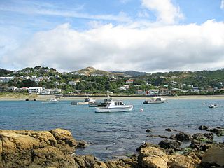
Island Bay is a coastal suburb of Wellington, the capital of New Zealand, situated 5 km south of the city centre.
Hataitai is an inner-city suburb of Wellington, the capital of New Zealand, 3.5 kilometres southeast of the city centre. The suburb extends over the southeastern flank of Mount Victoria and down a valley between the Town Belt and a ridge along the shoreline of Evans Bay. Hataitai is bounded by Hepara Street, Grafton Road and the suburb of Roseneath in the north, Wellington Harbour in the east, Cobham Drive, Wellington Road and Crawford Road in the south, and Alexandra Road in the west.

Brooklyn is a suburb of Wellington, the capital city of New Zealand.

The Aro Valley forms a small inner-city suburb of Wellington in New Zealand. It takes its name from the stream which originally flowed where modern Epuni Street is. The stream's Māori name was originally Wai-Mapihi, but it was commonly called Te Aro Stream due to it running through the Te Aro flat.
Mount Cook is an inner suburb of the metropolitan area of Wellington, The North Island, New Zealand, 1.74 km dead south of Wellington's Central Business District. Its local constituency area is the Wellington Central, and is part of the City of Wellington local government area. At the 2013 Census, Mount Cook had a population of 5, 112.

Te Āti Awa is a Māori iwi with traditional bases in the Taranaki and Wellington regions of New Zealand. Approximately 17,000 people registered their affiliation to Te Āti Awa in 2001, with around 10,000 in Taranaki, 2,000 in Wellington and around 5,000 of unspecified regional location.
Vogeltown is a suburb of New Plymouth, in the western North Island of New Zealand. It is located to the southeast of the city centre and east of Frankleigh Park. The suburb was named after Sir Julius Vogel, Prime Minister of New Zealand in the 1870s.

Muaūpoko is a Māori iwi on the Kapiti Coast of New Zealand.

Ngāti Tama is a historic Māori iwi of present-day New Zealand which whakapapas back to Tama Ariki, the chief navigator on the Tokomaru waka. The Iwi of Ngati Tama is located in north Taranaki around Poutama. On its northern boundary are the Tainui and Waikato/Maniapoto tribes, and on the southern boundary is Ngati Mutunga. The close geographical proximity of Tainui's Ngati Toa and Ngati Mutunga explains the long, continuous, and close relationship among the three Iwi.

Ōtara is a suburb of South Auckland, New Zealand, situated 18 kilometres to the southeast of the Auckland CBD. Ōtara lies near the head of the Tamaki River, which extends south towards the Manukau Harbour. Contemporary Ōtara is surrounded by the suburbs of Papatoetoe, East Tāmaki, Clover Park and Flat Bush. The suburb is noted for its proportion of Pacific Islander residents, who make up 78% of the Ōtara population, and its unusually low number of European New Zealanders (Pākehā) residents (10%).
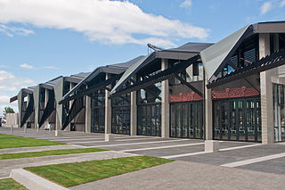
Te Raukura, otherwise known as Te Wharewaka o Poneke is a building located on Taranaki Street Wharf, Wellington waterfront, New Zealand. It houses a conference venue, Karaka Cafe, and waka house.