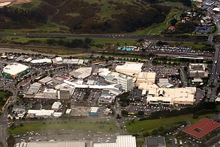
Porirua, a city in the Wellington Region of the North Island of New Zealand, is one of the four cities that constitute the Wellington metropolitan area. The name 'Porirua' is a corruption of 'Pari-rua', meaning "the tide sweeping up both reaches". It almost completely surrounds Porirua Harbour at the southern end of the Kapiti Coast. As of June 2021 Porirua had a population of 60,500.

Te Awa Kairangi / Hutt River flows through the southern North Island of New Zealand. It flows south-west from the southern Tararua Range for 56 kilometres (35 mi), forming a number of fertile floodplains, including Kaitoke, central Upper Hutt and Lower Hutt.

Wellington City Council is a territorial authority in New Zealand, governing the country's capital city Wellington, and de facto second-largest city. It consists of the central historic town and certain additional areas within the Wellington metropolitan area, extending as far north as Linden and covering rural areas such as Mākara and Ohariu. The city adjoins Porirua in the north and Hutt City in the north-east. It is one of nine territorial authorities in the Wellington Region.

Tawa is the northernmost suburb within the Wellington city boundary, located roughly 15 km north of Wellington's CBD between Churton Park and Porirua in the North Island of New Zealand. It takes its name from the broadleaf tree, which was once prolific throughout the area, although its most famous tree is the Bucket Tree, a large macrocarpa with the topiary of an upside-down bucket. Tawa is also known for its large number of churches, representing a wide range of Christian denominations.

Johnsonville is a large suburb in northern Wellington, New Zealand. It is seven kilometres north of the city centre, at the top of the Ngauranga Gorge, on the main route to Porirua. It is commonly known by locals as "J'ville".

Khandallah is a suburb of Wellington, the capital city of New Zealand. It is located 4 kilometres (2.5 mi) northeast of the city centre, on hills overlooking Wellington Harbour.

Ngaio is an inner suburb of Wellington, the capital city of New Zealand. It is situated on the slopes of Mount Kaukau, 3500 metres north of the city's CBD. It was settled in the 1840s and many of its streets are named after early settler families. Ngaio was originally a logging community known first as Upper Kaiwarra, then as Crofton until 1908. The area was administratively part of a separate local authority called the Onslow Borough Council which amalgamated with Wellington City in 1919.

Newlands is one of the northern suburbs of Wellington, New Zealand. It lies approximately 8.1 km north of the city centre and to the east of its nearest neighbour Johnsonville. It has a long history of early settlement and originally was farmed including being the early source of Wellington's milk. Newlands is located in a valley and covers two ridgelines, the side of one of which overlooks Wellington Harbour and up to the Hutt Valley.

The 8.38 miles (13.49 km) Tawa Flat deviation is a double-track section of the Kapiti Line just north of Wellington, New Zealand with two tunnels; the southernmost section of the North Island Main Trunk railway (NIMT) between Wellington and Auckland. It was built to bypass a limited capacity single track section of the original Wellington and Manawatu Railway (WMR) line which ascended from Wellington to Johnsonville and then descended to Tawa Flat. The original name of Tawa Flat was changed to Tawa in 1959.
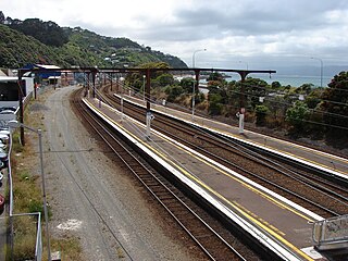
Kaiwharawhara railway station, a former railway station on the North Island Main Trunk and the Wairarapa Line in Wellington in New Zealand, closed in 2013. It was the first station north of Wellington, serving the early suburb of Kaiwharawhara. Prior to its closure it was served by trains operated by Tranz Metro as part of the Metlink network on the Melling Line, the Hutt Valley Line and the Kapiti Line.

Northland is an affluent suburb in west-central Wellington, New Zealand. Not far from Victoria University it also includes low-priced accommodation popular with young students. It borders the suburbs of Highbury, Kelburn, Thorndon, Wilton, Wadestown and Karori. Northland is populated by a mix of university students, young professionals and families. Part of the area was known as Creswick until the late 19th century when new roads and building sites were developed by the landowner, C J Pharazyn, who marketed the whole area as Northland. At that time it was described in the now defunct Evening Post as "Wellington's best suburb".

Wilton is a small suburb in Wellington. It is best known for Otari-Wilton's Bush, a large reserve that is situated in the suburb. Otari-Wilton's bush is the only public botanic garden in New Zealand dedicated solely to native plants. It features 14 km of walking tracks and a 'canopy walkway'. The canopy walkway is a raised walkway that provides a unique chance to view life in, and from, the top level of trees such as mature tawa, rewarewa and hinau.

Karehana Bay is a bay and nearby residential area at the western end of Plimmerton, a northern coastal locality of Porirua. It is located near the entrance to the Porirua Harbour, to the south-east of Hongoeka. It is about 5 minutes drive to Karehana Bay from the State Highway 59 turnoff to Plimmerton. The area looks out towards Mana Island and across Cook Strait to the South Island.

Wadestown is a northern suburb of Wellington, located about 2–3 km by road from the Wellington central business district and the New Zealand Parliament Buildings.

Crofton Downs is an inner suburb of Wellington, the capital city of New Zealand. It is situated between Ngaio to the northeast Wilton to the south-west and Wadestown to the south. Its border runs on the Korimako Stream that flows south into the Kaiwharawhara Stream and then flows down the Ngaio Gorge into Wellington Harbour.

Ohariu is a suburb of Wellington, New Zealand. It is a rural area, located 5 kilometres (3.1 mi) from Khandallah.
Paparangi, one of the northern suburbs of Wellington in New Zealand, lies approximately 10 km north of the city centre, north-east of Johnsonville, north-west of Newlands and south of Grenada and Woodridge. The population was 2,841 at the time of the 2013 census, an increase of 96 from the 2006 census population.
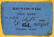
The Borough of Onslow was a local government district immediately to the north of Wellington, New Zealand. Incorporated on 13 March 1890 it included the districts of: Wadestown, Crofton, Khandallah and Kaiwarra but not Johnsonville. It replaced the Kaiwarra Town Board, the Wellington District Roads Board and a small part of the very wide jurisdiction of the Hutt County Council. Johnsonville Town Board remained independent.
The Old Porirua Road in the 19th century was the main road north up the west coast from Wellington to Porirua in New Zealand. It ran from Kaiwarra up the Ngaio Gorge to Ngaio, Khandallah, Johnsonville and Tawa to the Porirua Harbour. Most of the road still exists, although many sections are now local roads only, having been superseded as through roads.
Whitmore Street is at the boundary of the central business district and the government buildings area of Wellington, New Zealand's capital. The street runs almost north-south and is one of those linking Lambton Quay, Wellington's main shopping street, with Stout Street, Featherston Street and the harbourside at Customhouse/ Waterloo Quay. It is in the suburb of Pipitea.