Reclamation of Wellington Harbour

Last updated

An animation showing the phases of reclamation by year in Wellington Harbour. Wellington reclamation animation.gif
An animation showing the phases of reclamation by year in Wellington Harbour.

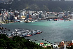
The reclamation of Wellington Harbour started in the 1850s, in order to increase the amount of usable land for the then new City of Wellington. Land plots in the early city were scarce, with little room for public buildings and parks, as well as inadequate dockside areas for shipping. Reclamation progressively advanced into the harbour throughout the 19th and 20th centuries, providing room for public, commercial and industrial areas for the city. Large reclamations were made in the 1960s and '70s to meet the demands of container shipping and new cargo handling methods.[ citation needed ] [1]

Contents

For over 100 years, development was largely overseen by the Wellington Harbour Board, formed in 1880. As one of the outcomes of the 1989 local government reforms, an operating company Port of Wellington (now CentrePort Wellington) was formed. At the time it commenced operation in 1989, it owned approximately 72 ha (180 acres) of Wellington waterfront property including wharves. The remainder of the Wellington waterfront area from Shed 21 to Clyde Quay Wharf, including all the buildings, was transferred to Wellington City Council. Since then, the formerly industrial waterfront has been converted into office space and public areas. [ citation needed ] Reclamation has added more than 155 hectares to Wellington. [2]

Establishment of Wellington

The Cuba anchored in Wellington Harbour by Charles Heaphy. Cuba in Wellington Harbour.jpg
The Cuba anchored in Wellington Harbour by Charles Heaphy.

A plan for the New Zealand Company's new settlement of Britannia at Pito-one (Petone) had been prepared in England by Samuel Cobham. [3] The key elements of his city were a large amount of flat land on the shores of a harbour, traversable by a navigable river. When surveyors arrived in 1840 on the Cuba led by Captain William Mein Smith, it was determined that the Hutt River was not navigable and, due to its tendency to flood, was not appropriate to support a major city. [4] For these reasons the new settlement was relocated to the southern shores of Port Nicholson and renamed Wellington. [5]

Edward Gibbon Wakefield of the New Zealand Company had devised a system of "packages" of land for colonists of one town acre each. Cobham's Brittania consisted of 1100 1-acre (4,000 m2) town sections, which William Mein Smith struggled to fit into the new location. These sections were squeezed into the available space by sacrificing many of the planned amenities such as parks, reserves, ports, libraries and many other public areas identified in the original plan. [6] For this reason, from Wellington's outset, there was a need for extra land.

19th century reclamations

Map of proposed reclamation of the area on the harbour side of Lambton Quay from 1851. Harbour improvements Wellington.JPG
Map of proposed reclamation of the area on the harbour side of Lambton Quay from 1851.
Two men fishing off the reclamations at Te Aro, in the vicinity of Cable Street, Wellington. Photograph taken circa. 1910. Men fishing off reclamation Wellington Harbour.JPG
Two men fishing off the reclamations at Te Aro, in the vicinity of Cable Street, Wellington. Photograph taken circa. 1910.

Early reclamations

While large scale reclamation began in the 1850s, the earliest reclamations in Wellington were conducted by private citizens. A popular story of the first reclamation conducted in Wellington was that done by George Bennet. [7] Bennet had arrived in 1848 on the Berenicia and purchased a hilly section at Windy, or Clay Point (what is now the corner of Lambton Quay and Willis Street). At that time, Windy Point was a precipice with a narrow and often impassible path connecting Willis Street to Beach Road (now Lambton Quay). Bennet commenced, to the amusement of neighbours, with pick-axe, shovel and barrow to move earth from the Point, tossing the spoil onto the path and into the harbour, thus widening the track and performing Wellington's first reclamation. [8]

A programme of systematic reclamation began in 1852, overseen by the provincial government. Charles Carter completed a 360' x 100' extension below Willis Street at a cost of £1,036. [9]

In 1855, the magnitude 8.2 Wairarapa earthquake uplifted the northwestern side of Wellington bay (in some places up to 1.5 metres [10] ). This created a tidal swamp, and rendered many of the existing jetties in the harbour unusable. Most of this land was subsequently reclaimed, providing an excellent new rail and road route to the north. Another result of the newly raised land in Wellington was that the shipping basin planned for the city was abandoned and the land then used for a cricket ground, the Basin Reserve. [11]

Establishment of the Wellington Harbour Board

The Wellington City Council was inaugurated in 1870, and by the end of the 1870s some 70 acres (280,000 m2) of land had been reclaimed using spoil from the hills behind Lambton Quay and from Wadestown Hill. [12]

In 1880, the Wellington Harbour Board was established to manage and develop the harbour and its facilities. [13] From then on reclamation work was divided between the Harbour Board, the Government and the City Council. Among major developments from 1880 to the turn of the century was reclamation north of Pipitea Point for railways land and south of Queens Wharf to Te Aro by the City Council. This removed the last vestiges of private ownership of the foreshore, putting the waterfront under the control of the Harbour Board.

By the end of the 19th century, the original 1840 shoreline was unrecognisable.

20th century reclamations

Reclamation in Thorndon circa. 1925. Land reclamation Thorndon.JPG
Reclamation in Thorndon circa. 1925.

From 1900 to 1930 further reclamations were made for railways and Harbour Board purposes. Additional wharves and the seawall at Oriental Bay were built, and the boat harbour at Clyde Quay was constructed.

1960s and container shipping

The harbour as it looks today from Mount Victoria. Lambton Harbour, Wellington.jpg
The harbour as it looks today from Mount Victoria.

The final phase of reclamation took place in the 1960s and 1970s. A government report in 1967 recommended the adoption of containerisation and that Wellington should be one of the two New Zealand container ports. [14] With containerisation came new roll-on/roll-off cargo handling methods that require more land adjacent to ships' berths. This resulted in the start of an extension to the Aotea Quay reclamation. Reclamation was carried out on both sides of Queens Wharf and the Wellington Harbour Board Container Terminal was created by a large reclamation at Thorndon.

The first container ship berthed on 19 June 1971. [14] The container terminal has 24.3 hectares of back-up space capable of holding 6,284 containers. [15]

Port reforms

A plaque laid by the Historic Places Trust to mark Wellington's original shoreline. Shoreline plaque Wellington.jpg
A plaque laid by the Historic Places Trust to mark Wellington's original shoreline.

The Wellington Harbour Board was disestablished after the passing of the Port Companies Act 1988 and the Local Government Act 1989, as part of the 1989 local government reforms. Operational port assets were transferred to a new company called Port of Wellington. [16] [17] Ownership of the Port of Wellington company was vested in Greater Wellington Regional Council, and Horizons Regional Council. When the port company was formed, it owned approximately 72 ha (180 acres) of Wellington waterfront property including wharves. The remainder of the Wellington waterfront area, from Shed 21 to Clyde Quay Wharf, including all the buildings, was transferred to Wellington City Council. [18] :13

Port of Wellington changed its name to Port Wellington in 1997 and then to CentrePort Wellington in May 1999, to emphasise that fact that the port is in the centre of New Zealand and able to serve a large geographical area. [19]

Marking the original shoreline

In 1976, the Historic Places Trust placed 14 plaques along the original shoreline. [20] These plaques run from Pipitea Point, along Lambton Quay, through Mercer Street, lower Cuba Street, Wakefield Street to Oriental Parade at the northern corner of Herd Street.

Timeline of reclamations

From the New Zealand Electronic Text Centre: [21]

Year/sLocationArea
1852Willis Street, Mercer Street, Chew's Lane, Bonds
1857-63Bank of N.Z., corner Willis Street and Lambton Quay (Noah's Ark site), Harris Street to Grey Street7 acres (28,000 m2)
1859Oddfellows' Hall site
1864Foresters' Lodge site
1865Messrs. Jacob Joseph, between Waring Taylor and Stout Streets and Lambton Quaytotal of last three, 2 rods
1866–67Panama, Brandon, Johnston and Waring Taylor Streets, pts. Featherston Street and Customhouse Quay12 acres (49,000 m2)
1875Government Building site2 acres (8,100 m2)
1876Government (Lambton) railway station and lines, Featherston Street extension, Ballance, Stout, Bunny and Whitmore Streets, Govt. Printing Office and “Shacks” (this was extended to Pipitea Point)46 acres (190,000 m2)
1882Manawatu (Thorndon) railway station and lines29 acres (120,000 m2)
1882Railway Wharf1 rod
1884Davis Street Extension
1886Hunter Street endowment, Customhouse Quay and Hunter Street3 rods
1886Victoria and Wakefield Streets22 acres (89,000 m2)
1889Jervois Quay17 acres (69,000 m2)
1893Harbour Board store, and track for Te Aro railway, Customhouse Quay and Jervois Quay1-acre (4,000 m2)
1893–1901Waterloo Quay and Glasgow wharves3 acres (12,000 m2)
1895Council's yards, near Oriental Parade1-acre (4,000 m2)
1901–03From near Queen's Wharf to the Lyttelton Ferry Wharf, and site of Customhouse2.5 acres (10,000 m2)
1901–1914Barnet, Cable and Chaffers Street18 acres (73,000 m2)
1902–1925Clyde Quay widening4 acres (16,000 m2)
1904Hutt Road locality
1904–1916Waterloo and near Fryatt Quays, Hinemoa and Cornwall Streets34 acres (140,000 m2)
1906Waterloo Quay completion34.5 acres (140,000 m2)
1906Oriental Parade and boat shed sites1-acre (4,000 m2)
1910–1913Davis Street extension, near Cornwall Street4 acres (16,000 m2)
1924–1927Thorndon Esplanade and Hutt railway lines areas, vested in the Harbour Board and Railway Department

See also

Related Research Articles

<span class="mw-page-title-main">Wellington Harbour</span> Harbour in New Zealand

Wellington Harbour is a large natural harbour on the southern tip of New Zealand's North Island. Central Wellington is located on parts of its western and southern sides, and the suburban area of Lower Hutt is located on parts of its northern and eastern sides.

<span class="mw-page-title-main">Thorndon, New Zealand</span> Suburb of Wellington City, New Zealand

Thorndon is a historic inner suburb of Wellington, the capital city of New Zealand. Because the suburb is relatively level compared to the hilly terrain elsewhere in Wellington it contained Wellington's elite residential area until its best was destroyed in the 1960s by a new motorway and the erection of tall office buildings on the sites of its Molesworth Street retail and service businesses.

<span class="mw-page-title-main">Toronto Harbour</span> Bay on the north shore of Lake Ontario, in Toronto, Ontario, Canada

Toronto Harbour or Toronto Bay is a bay on the north shore of Lake Ontario, in Toronto, Ontario, Canada. It is a natural harbour, protected from Lake Ontario waves by the Toronto Islands. Today, the harbour is used primarily for recreational boating, including personal vessels and pleasure boats providing scenic or party cruises. Ferries travel from docks on the mainland to the Islands, and cargo ships deliver aggregates and raw sugar to industries located in the harbour. Historically, the harbour has been used for military vessels, passenger traffic and cargo traffic. Waterfront uses include residential, recreational, cultural, commercial and industrial sites.

<span class="mw-page-title-main">Lambton Quay</span> Street in Wellington, New Zealand

Lambton Quay is the heart of the central business district of Wellington, the capital city of New Zealand.

<span class="mw-page-title-main">Te Aro</span> Suburb of Wellington City, New Zealand

Te Aro is an inner-city suburb of Wellington, New Zealand. It comprises the southern part of the central business district including the majority of the city's entertainment district and covers the mostly flat area of city between The Terrace and Cambridge Terrace at the base of Mount Victoria.

<span class="mw-page-title-main">Port of San Francisco</span> Organization that oversees port facilities in San Francisco, California, United States

The Port of San Francisco is a semi-independent organization that oversees the port facilities at San Francisco, California, United States. It is run by a five-member commission, appointed by the Mayor and approved by the Board of Supervisors. The Port is responsible for managing the larger waterfront area that extends from the anchorage of the Golden Gate Bridge, along the Marina district, all the way around the north and east shores of the city of San Francisco including Fisherman's Wharf and the Embarcadero, and southward to the city line just beyond Candlestick Point. In 1968 the State of California, via the California State Lands Commission for the State-operated San Francisco Port Authority, transferred its responsibilities for the Harbor of San Francisco waterfront to the City and County of San Francisco / San Francisco Harbor Commission through the Burton Act AB2649. All eligible State port authority employees had the option to become employees of the City and County of San Francisco to maintain consistent operation of the Port of San Francisco.

<span class="mw-page-title-main">Wellington railway station</span> Railway station in New Zealand

Wellington railway station, or Wellington Central station, is the main railway station serving Wellington, New Zealand, and is the southern terminus of the North Island Main Trunk, Wairarapa Line and Johnsonville Line.

<span class="mw-page-title-main">Ports of Auckland</span> Company administering Aucklands harbour facilities

Ports of Auckland Limited (POAL), the successor to the Auckland Harbour Board, is the Auckland Council-owned company administering Auckland's commercial freight and cruise ship harbour facilities. As the company operates all of the associated facilities in the Greater Auckland area, this article is about both the current company and the ports of Auckland themselves.

<span class="mw-page-title-main">Kaiwharawhara</span> Suburb in Wellington, New Zealand

Kaiwharawhara is an urban seaside suburb of Wellington in New Zealand's North Island. It is located north of the centre of the city on the western shore of Wellington Harbour, where the Kaiwharawhara Stream reaches the sea from its headwaters in Karori. It is a largely commercial and industrial area and thus has little residential population. A recent housing development up the hillside towards Te Kainga has increased the resident population.

<span class="mw-page-title-main">Auckland waterfront</span>

The Auckland waterfront is a city-side stretch of the southern Waitematā Harbour coastline in Auckland, New Zealand. Previously mostly dominated by Ports of Auckland uses, from the 2000s on it is becoming increasingly open to recreational public use, with a number of former wharves being converted to office, entertainment, and later also some residential uses.

<span class="mw-page-title-main">Frank Kitts Park</span>

Frank Kitts Park is a public park situated between Jervois Quay and the Lambton Harbour waterfront in Wellington, New Zealand. It is named after Sir Frank Kitts, New Zealand politician and mayor of Wellington.

<span class="mw-page-title-main">Lyttelton railway station</span> Railway station in New Zealand

Lyttelton railway station is the northern terminus of the Main South Line, a main trunk railway line from Lyttelton to Invercargill in the South Island of New Zealand. There have been three stations built at Lyttelton, with the most recent of these still being used for railway purposes.

<span class="mw-page-title-main">Toronto Harbour Commission</span>

The Toronto Harbour Commission (THC) was a joint federal-municipal government agency based in Toronto, Ontario, Canada. The agency managed Toronto Harbour as well as being responsible for major works along the Toronto waterfront. It built both Malton Airport and the Toronto Island Airport in 1939. The agency was founded in 1911 and operated until 1999 when the port operations were transferred to the new Toronto Port Authority (TPA), now PortsToronto.

Pipitea Point railway station, a temporary building for the Hutt and Masterton railway, was Wellington's first railway station opened on 14 April 1874 with the Hutt Valley Line. The railway line from Wellington to Lower Hutt was started in 1872 and opened in 1874.

<span class="mw-page-title-main">Wellington Harbour Board</span> Board elected to levy dues on goods passing through Wellington Harbour

The Wellington Harbour Board was constituted by act of parliament which took effect on 1 January 1880. Shipowners, those paying harbour dues, Wellington City, Hutt County, Wairarapa County, and Wellington's Chamber of Commerce all elected representatives to the board. The Mayor of Wellington was a member as was one further direct government appointment.

<span class="mw-page-title-main">Lambton railway station</span> Defunct railway station in Wellington, New Zealand

Lambton originally Wellington railway station in Featherston Street, Wellington, New Zealand was the southern passenger terminus for the Hutt Line and the Wairarapa Line from 1885 to 1936 and for lines further north until December 1908. Wellington's third railway station it had been preceded by station buildings temporarily at Pipitea Point and a site further south on Featherston Street beside Wellington's rail freight depot and its Railway Wharf.

Quay Street is the northernmost street in the Auckland CBD, New Zealand. The Auckland Ferry Terminal, which has ferries running to Devonport, Waiheke Island, and other places in Waitematā Harbour; the Hilton Auckland hotel; and Ports of Auckland are on the north side of the street. The Britomart Transport Centre, Queen Elizabeth Square and Grand Mercure Auckland hotel are on the south side.

<span class="mw-page-title-main">Whitmore Street</span>

Whitmore Street is at the boundary of the central business district and the government buildings area of Wellington, New Zealand's capital. The street runs almost north-south and is one of those linking Lambton Quay, Wellington's main shopping street, with Stout Street, Featherston Street and the harbourside at Customhouse/ Waterloo Quay. It is in the suburb of Pipitea.

<span class="mw-page-title-main">CentrePort Wellington</span> Port operating company in Wellington

CentrePort Wellington (CentrePort) provides land and sea infrastructure and manages port facilities in Wellington Harbour in New Zealand. The company is the successor to the Wellington Harbour Board, and was formed as one of the outcomes of the 1989 local government reforms. This article is about both the company and the port.

<span class="mw-page-title-main">Wharves in Wellington Harbour</span> Wharves in Wellington

Wharves in Wellington Harbour have been essential to the operation of the Port of Wellington, and to the development of the city and the lower half of the North Island of New Zealand.

References

  1. Waterfront Reclamation, Wellington City Council Dead link.
  2. Wellington City Council's Old Shoreline Trail Archived 2011-10-11 at the Wayback Machine
  3. New Zealand History Online
  4. An Encyclopedia of New Zealand 1966
  5. New Zealand history online
  6. Wellington Waterfront Limited
  7. Louis E. Ward (1928). "Early Wellington". Whitcombe and Tombs Limited, republished by NZETC.
  8. Louis E. Ward (1928). "Early Wellington". Whitcombe and Tombs Limited, republished by NZETC.
  9. Wellington Waterfront Limited
  10. Christchurch City Libraries
  11. Te Ara: Encyclopedia of New Zealand, The 1855 Wairarapa earthquake
  12. Wellington Waterfront Limited
  13. Wellington Waterfront Limited
  14. 1 2 "Wellington Harbour Board - History & Photos". New Zealand Ship and Marine Society. Archived from the original on 14 October 2008.
  15. Waterfront Reclamation, Wellington City Council
  16. McLean, Gavin (2001). Captain's log: New Zealand's maritime history. Auckland, New Zealand: Hodder Moa Beckett. p. 189. ISBN   1-86958-881-9.
  17. Yska, Redmer (2006). Wellington: biography of a city. Wellington, New Zealand: Reed. p. 234. ISBN   978-0-7900-1107-3.
  18. Fill, Barbara; Astwood, Karen (2012). "Registration Report for a Historic Area: Wellington Harbour Board Historic Area (Volume I)" (PDF). New Zealand Historic Places Trust. Archived (PDF) from the original on 9 February 2021. Retrieved 31 May 2023.
  19. Love, Phil (27 May 1999). "Port Wellington unveils new image". Evening Post. ProQuest   314657231.
  20. Waterfront Reclamation, Wellington City Council
  21. Louis E. Ward (1928). "Early Wediclington". Whitcombe and Tombs Limited, republished by NZETC.