Mitchell Recreation Area

Last updated
Mitchell Recreation Area
Mitchell Monument; August 12, 2013.jpg
Mitchell Monument
Location Fremont-Winema National Forests
Nearest city Bly, Oregon, USA
Coordinates 42°25′54″N120°51′39″W / 42.4316°N 120.8607°W / 42.4316; -120.8607
Built1950
NRHP reference No. 03000050
Added to NRHP2003

Mitchell Recreation Area is a small picnic area located in the Fremont-Winema National Forests, Lake County, Oregon, near the unincorporated community of Bly. In it stands the Mitchell Monument, erected in 1950, which marks the only location in the United States where Americans were killed during World War II as a direct result of a Japanese balloon bomb. The site is maintained by the United States Forest Service and was listed on the National Register of Historic Places in 2001.

Contents

History

The Christian and Missionary Alliance church in Bly, Oregon Bly CMA Church.jpg
The Christian and Missionary Alliance church in Bly, Oregon

On May 5, 1945, Reverend Archie Mitchell took his pregnant wife and five Sunday school children, from the Christian and Missionary Alliance church where he was minister, [1] on a picnic and fishing trip. The group found the logging road they followed blocked, so they stopped next to Leonard Creek, eight miles (13 km) east of Bly near Gearhart Mountain. While Mitchell was unloading the food, he heard one of the children say, "Look what I found!" His wife and the children ran to see what had been found. Moments later, there was an explosion. Mrs. Mitchell and the boys were killed instantly; one of the children, Joan, survived the initial blast but died minutes later. Rev. Mitchell’s hands were burned from trying to put out Mrs. Mitchell’s dress which had caught fire. [2] [3] [4] [5]

The children had found the remains of a Japanese balloon bomb, one of approximately 9,000 balloon bombs launched from Honshū, Japan between November 1944 and April 1945. The balloons drifted across the Pacific Ocean to North America via the jet stream in about three days. The hydrogen-filled balloons were 33 feet (10 m) in diameter and carried five bombs, four incendiaries and one anti-personnel high explosive. It is believed that as many as 1,000 balloons may have reached the United States and Canada. However, there were only 285 confirmed sightings on the west coast, and two balloons were later found in Michigan. Except for Elsye (aka Elsie) Mitchell and the five children killed near Bly, the bombs caused no injuries. These six individuals were the only Americans killed in the United States during World War II as a direct result of an Axis balloon bomb detonation. [2] [3] [4] [6] [7] In 1976, Sakyo Adachi, a Japanese scientist who helped plan the balloon offense, visited the site and laid a wreath at the monument. He later sent a letter of apologies to the Patzke family for the loss of their two children. [4]

In 1995, Japanese students sent 1,000 paper cranes, a Japanese symbol of peace and healing, to the families of the victims. Six cherry trees were also delivered to Bly to be planted at the site. One of the cherry trees was planted just north of the fenced monument site. The remaining trees were planted inside the fenced area. Later that year, over 500 people attended the 50th anniversary re-dedication ceremony at the Mitchell Monument site. [3] [4]

The Mitchell Monument site was originally owned by Weyerhaeuser Corporation. In 1996, Weyerhaeuser donated land around the monument to the Fremont National Forest (now the Fremont-Winema National Forests). Additional property was added to the site in 1997. A small picnic area was developed around the monument. [3] [4]

During the summer of 2021, the Bootleg Fire burned over the area surrounding Mitchell Monument. However, fire crews were able to save the historic site from the flames. As the fire approached, fire crews trimmed low hanging tree branches and built a fire line around the monument site. They also wrapped the shrapnel tree and the stone monument in a fire-resistant material similar to the material used for the firefighter’s emergency shelters. As a result, when the fire passed through the adjacent forest, the monument was undamaged. [8] [9]

Monument

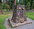
The Mitchell Monument was erected by Weyerhaeuser in 1950. It was designed by Tom Orr, a Weyerhaeuser forester. The stone structure was built by Robert H. Anderson, a local monument builder and stonemason. It is constructed of native stone and displays a bronze plaque with the names and ages of the victims of the balloon bomb explosion. It commemorates the "only place on the American continent where death resulted from enemy action during World War II". [2] [3] [4] [10] Approximately 500 people attended the monument's dedication on August 20, 1950. Oregon Governor Douglas McKay spoke at the ceremony. [11] [12]

Here are the words from the monument plaque:

WEYERHAUSER COMPANY

EASTERN OREGON REGION

IN MEMORY OF
ELSIE MITCHELL AGE 26
DICK PATZKE AGE 14
JAY GIFFORD AGE 13
EDWARD ENGEN AGE 13
JOAN PATZKE AGE 13
SHERMAN SHOEMAKER AGE 11

WHO DIED HERE
MAY 5, 1945

BY
JAPANESE BOMB EXPLOSION

ONLY PLACE ON THE
AMERICAN CONTINENT
WHERE DEATH RESULTED
FROM ENEMY ACTION

DURING WORLD WAR II

Mitchell Monument plaque

Because it commemorates an important wartime event that occurred at the site, the monument is of significant historical value. Therefore, the Mitchell Monument site was listed on the National Register of Historic Places on February 20, 2003. [3] [4]

Recreation area

Today, the Bly Ranger District maintains Mitchell Recreation Area as a day-use picnic area. The site covers 22.7 acres (9.2 ha). It is adjacent to Leonard Creek and is sheltered by large ponderosa pines. In addition to the monument, the site offers fishing, hiking, and wildlife viewing opportunities. The site is normally open from mid-May until the end of October. [2] Adjacent to the monument is the "shrapnel tree", a ponderosa pine still bearing scars from the explosion. In 2005, the State of Oregon designated the shrapnel tree at the Mitchell Monument site as an Oregon Heritage Tree . [3]

See also

Related Research Articles

<span class="mw-page-title-main">Fu-Go balloon bomb</span> WWII Japanese incendiary weapon

Fu-Go was an incendiary balloon weapon deployed by Japan against the United States during World War II. It consisted of a hydrogen-filled paper balloon 33 feet (10 m) in diameter, with a payload of four 11-pound (5.0 kg) incendiary devices and one 33-pound (15 kg) high-explosive anti-personnel bomb. The uncontrolled balloons were carried over the Pacific Ocean from Japan to North America by fast, high-altitude air currents, today known as the jet stream, and used a sophisticated sandbag ballast system to maintain their altitude. The bombs were intended to ignite large-scale forest fires and spread panic.

<span class="mw-page-title-main">Lakeview, Oregon</span> Town in Oregon, United States

Lakeview is a town in Lake County, Oregon, United States. The population was 2,418 at the 2020 census. It is the county seat of Lake County. The city bills itself as the "Tallest Town in Oregon" because of its elevation, 4,757 feet (1,450 m) above sea level. Lakeview is situated in the Goose Lake Valley at the foot of the Warner Mountains and at the edge of Oregon's high desert country. Its economy is based on agriculture, lumber production, and government activities. In addition, tourism is an increasingly important part of the city's economy. Oregon's Outback Scenic Byway passes through Lakeview.

<span class="mw-page-title-main">Smokey Bear</span> U.S. Forest Service mascot used to raise awareness about wildfires

Smokey Bear is an American campaign and advertising icon of the U.S. Forest Service in the Wildfire Prevention Campaign, which is the longest-running public service announcement campaign in United States history. The Ad Council, the United States Forest Service (USFS), and the National Association of State Foresters (NASF), in partnership with creative agency FCB, employ Smokey Bear to educate the public about the dangers of unplanned human-caused wildfires.

<span class="mw-page-title-main">Bly, Oregon</span> Unincorporated community in the state of Oregon, United States

Bly is an unincorporated community in Klamath County, Oregon, United States. By highway, it is about 50 miles (80 km) east of Klamath Falls. As of 2020, the population was 207.

<span class="mw-page-title-main">OC&E Woods Line State Trail</span>

The OC&E Woods Line State Trail is a rail trail in Klamath and Lake counties in the U.S. state of Oregon. It is Oregon's longest state park. The trail follows the old OC&E and Weyerhaeuser railroads from Klamath Falls to Thompson Reservoir. Along its 105-mile (169 km) length it passes through the communities of Olene, Sprague River, Dairy, Beatty, and Bly.

The Fremont-Winema National Forest of south central Oregon is a mountainous region with a rich geological, ecological, archaeological, and historical history. Founded in 1908, the Fremont National Forest was originally protected as the Goose Lake Forest Reserve in 1906. The name was soon changed to Fremont National Forest, named after John C. Frémont, who explored the area for the United States Army Corps of Engineers in 1843. It absorbed part of Paulina National Forest on July 19, 1915. In 2002, it was administratively combined with the Winema National Forest as the Fremont–Winema National Forests.

<span class="mw-page-title-main">Fremont–Winema National Forest</span> Protected area in the U.S. state of Oregon

The Fremont–Winema National Forest is a United States National Forest formed from the 2002 merger of the Fremont and Winema National Forests. They cover territory in southern Oregon from the crest of the Cascade Range on the west past the city of Lakeview to the east. The northern end of the forests is bounded by U.S. Route 97 on the west and Oregon Route 31 on the east. To the south, the state border with California forms the boundary of the forests. Klamath Falls is the only city of significant size in the vicinity. The forests are managed by the United States Forest Service, and the national forest headquarters are located in Lakeview.

<span class="mw-page-title-main">Lookout Air Raids</span> Japanese air raids on Oregon during WWII

The Lookout Air Raids were minor but historic Japanese air raids that occurred in the mountains of Oregon, several miles outside Brookings during World War II.

The Reverend Archie Emerson Mitchell was a minister with the Christian and Missionary Alliance (C&MA). He was born in Franklin, Nebraska. He attended Simpson Bible College and Nyack Missionary College. Mitchell served as a missionary to South Vietnam working on the staff of the Ban Me Thuot Leprosarium when he was taken captive by the Vietcong on May 30, 1962, along with Daniel Amstutz Gerber and Dr. Eleanor Ardel Vietti. None of the three have been seen since.

<span class="mw-page-title-main">Bly Ranger Station</span> United States historic place

The Bly Ranger Station is a United States Forest Service compound that serves as the headquarters for the Bly Ranger District which is an administrative subdivision of the Fremont National Forest. It is located in the small unincorporated community of Bly in southcentral Oregon. The ranger station was constructed by the Civilian Conservation Corps between 1936 and 1942. Today, the seven original buildings are still used by the Bly Ranger District. The compound was listed on the National Register of Historic Places as a historic district in 1981.

<span class="mw-page-title-main">Lake of the Woods (Oregon)</span> Lake in Oregon, United States

Lake of the Woods is a natural lake near the crest of the Cascade Range in the Fremont–Winema National Forest in southern Oregon in the United States. The lake covers 1,146 acres (4.64 km2). It was named by Oliver C. Applegate in 1870. Today, the Oregon Department of Fish and Wildlife manages the lake's fishery. The small unincorporated community of Lake of the Woods is located on the east shore of the lake. Lake of the Woods is one of southern Oregon's most popular outdoor recreation sites.

<span class="mw-page-title-main">Lake of the Woods Ranger Station</span> United States historic place

The Lake of the Woods Ranger Station is a United States Forest Service compound consisting of eight buildings overlooking Lake of the Woods in the Fremont-Winema National Forests of southern Oregon. All of the ranger station structures were built by the Civilian Conservation Corps between 1937 and 1939. Today, the compound serves as a Forest Service work center, and the old ranger station office is a visitor center. The ranger station is listed on the National Register of Historic Places.

<span class="mw-page-title-main">Hager Mountain</span> Volcanic peak in Oregon

Hager Mountain is a volcanic peak in Oregon in the northwest corner of the Basin and Range Province in the United States. The mountain is located south of the small unincorporated community of Silver Lake in south-central Oregon, and it is in the Fremont–Winema National Forest. On the summit, there is a fire lookout operated during the summer and fall by the United States Forest Service. There are several hiking trails that lead to the lookout station.

<span class="mw-page-title-main">Barry Point Fire</span> 2012 wildfire in Oregon and California

The Barry Point Fire was a wildfire that burned over 92,977 acres (376.26 km2) of Oregon and California forest land during the summer of 2012. The fire began on 5 August 2012, the result of a lightning strike. The fire consumed public forest and rangeland as well as private forest and grazing land located in Lake County, Oregon and Modoc County, California. The public lands affected by the fire are administered by the United States Forest Service and the Oregon Department of Forestry. The largest part of the private land was owned by the Collins Timber Company. At the peak of the firefighting effort, there were 1,423 personnel working on the fire. It took 22 days to fully contain the fire and then an additional three weeks to mop it up.

<span class="mw-page-title-main">Crane Mountain</span> Mountain in Oregon

Crane Mountain is in the Warner Mountain range and is the tallest peak in Lake County, Oregon, U.S. It is located southeast of Lakeview in south-central Oregon, near the northwest corner of the Basin and Range Province of the western United States. The mountain is in the Fremont section of the Fremont–Winema National Forest. There was a United States Forest Service fire lookout located near the summit which was removed in 1972. The Crane Mountain National Recreation Trail runs north and south along the crest of the mountain.

<i>Winema</i> (sternwheeler)

Winema was the largest steamboat ever to operate on Upper Klamath Lake in the U.S. state of Oregon. The steamer ran from 1905 to 1919, when it was hauled out of the water permanently. Winema was sunk by a sudden squall in August 1907. The vessel was raised, rebuilt and returned to service. The steamer remained out of the water for a number of years in the 1920, until it caught fire in 1925 or 1927 and was destroyed.

<span class="mw-page-title-main">2017 Oregon wildfires</span>

The 2017 Oregon wildfires were a series of wildfires that burned over the course of 2017.

<span class="mw-page-title-main">High Cascades Complex fires</span> Series of forest fires in Oregon

The High Cascades Complex was a group of 20 fires burning in four protected areas in Oregon, in the United States, specifically: Crater Lake National Park, Rogue River – Siskiyou National Forest, Umpqua National Forest, and Fremont–Winema National Forest. The first fire in the complex, the Blanket Creek Fire, was started by a lightning strike on July 29, 2017. In total, the fires have burned 72,309 acres (293 km2) and are 28% contained. The fires are directly impacting the communities of Prospect, Union Creek and Diamond Lake, park headquarters, old growth forests that house endangered species like the spotted owl and volcanic features.

<span class="mw-page-title-main">Bootleg Fire</span> 2021 wildfire in the U.S. state of Oregon

The Bootleg Fire, named after the nearby Bootleg Spring, was a large wildfire that started near Beatty, Oregon, on July 6, 2021. Before being fully contained on August 15, 2021, it had burned 413,765 acres. It is the third-largest fire in the history of Oregon since 1900. At the fire's fastest growth in mid July, it grew at about 1,000 acres (400 ha) per hour, and it became the second largest wildfire in the United States of the 2021 wildfire season.

The following is a timeline of the history of Oregon in the United States of America.

References

  1. UP (June 1, 1945). "Saw Wife and 5 Children Killed by Jap Balloon Bomb". The Seattle Times . stelzriede.com. Retrieved 2008-04-03.
  2. 1 2 3 4 "Mitchell Monument Historic Site". Fremont-Winema National Forests. 6 April 2014. Retrieved 2014-04-06.
  3. 1 2 3 4 5 6 7 "Mitchell Monument", Pacific Northwest Region, United States Forest Service, United States Department of Agriculture, Portland, Oregon, January 2012.
  4. 1 2 3 4 5 6 7 "Mitchell Recreation Area", National Register of Historic Places Registration Form, National Park Service, United States Department of Interior, Eugene, Oregon, 31 December 2002.
  5. "Balloon Bombs". The Oregon Encyclopedia. Retrieved December 26, 2013.
  6. Robert Donnelly (2002). "War Memorial, Lake County". Oregon History Project. Oregon Historical Society . Retrieved 2008-03-10.
  7. Francine Uenuma (2019-05-03). "In 1945, a Japanese Balloon Bomb Killed Six Americans, Five of Them Children, in Oregon". Smithsonian.com. Smithsonian Institution. Retrieved 2019-05-27.
  8. Perry, Douglas, "Bootleg Fire Crews Save Monument to WWII Tragedy", Oregonian/OregonLive, Portland, Oregon, 20 July 2021.
  9. Perry, Douglas, "Crews Saved a World War II Memorial from the Bootleg Fire", New York Times, New York, New York, 21 July 2021.
  10. Richard, Terry, "Oregon connection to World War II", The Oregonian , Portland, Oregon, 5 April 2007.
  11. "Sunday rites to Commemorate Spot Where Enemy Bomb Killed Six Civilians", The Oregonian, Portland, Oregon, 18 August 1950.
  12. "Germ-Filled Bomb Borne by Balloon, War Possibility", The Oregonian, Portland, Oregon, 21 August 1950.