
Havelock is a small town in the Marlborough Region of New Zealand, at the head of Pelorus Sound / Te Hoiere, one of the Marlborough Sounds, and at the mouth of the Pelorus and Kaituna Rivers
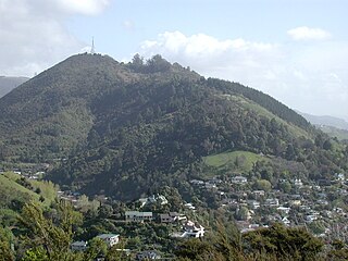
The Grampians are a set of prominent hills forming the southeast backdrop of Nelson, New Zealand, reaching 390 metres (1,280 ft) high.
Tamarau is a suburb of the New Zealand city of Gisborne. It is located to the southeast of the city centre.
Wai o Taiki Bay is a suburb in Auckland, New Zealand. It is under the local governance of Auckland Council.

Culverden is a small town in the northern Canterbury region of New Zealand's South Island. Culverden has traditionally been surrounded by sheep farms. Dairy farms have now become more common as a result of irrigation schemes in the area. The Waiau Plains Irrigation Scheme was completed in 1980. It provides irrigation to 17,000 hectares of farmland and the Balmoral Scheme provides irrigation to a further 5500 hectares. The Rutherford Reserve and the Culverden Recreation Reserve are on the southern side of Culverden and the Culverden Golf Course in on the northern entrance to Culverden. There is a memorial in the Rutherford Reserve to Dr Charles Little who died in November 1918 from the Spanish Flu. He was the county doctor providing medical services from Waikari to Waiau.
Cloverlea is a suburb of Palmerston North, New Zealand. The suburb is located north east of Highbury, north west of Palmerston North Hospital Area and north of Takaro.

Moana is a small town in the West Coast Region of the South Island of New Zealand. It is situated on the northern shore of Lake Brunner, and is beside the outflow of the lake into the Arnold River. There is a pedestrian suspension bridge crossing the Arnold from the town to access the lake shore across the river, with some short easy bush walks on each side. The town's main tourist attractions are the panoramic views and water sport opportunities arising from its position on the shores of Lake Brunner. The Midland Line railway passes through Moana; the TranzAlpine tourist passenger train passes through once in each direction daily, and freight trains of coal operate more frequently.
Awapuni is a suburb of the New Zealand city of Gisborne, located in the southwest of the city. It is named after the Awapuni lagoon, where the Waipaoa River runs into the ocean. The New Zealand Ministry for Culture and Heritage gives a translation of "blocked-up river" for Awapuni.
The Wood is a suburb of the South Island, New Zealand city of Nelson. It lies just to the north-east of the city centre and adjoins it.
Tahuna is a small rural settlement located 18 km north of Morrinsville. In the Māori language Tahuna means sandbank, likely to refer to the sandbanks along the nearby Piako River, where a Māori settlement started. Tahuna is seen as the upper limit for navigatable travel on the Piako River. The settlement has a rugby club, a lawn bowls club, a golf course and various shops.
Tāhunanui is one of the suburbs of Nelson, New Zealand. It lies between Port Nelson and Nelson Airport and is the site of the main beach for Nelson with a shoreline on the Tasman Bay / Te Tai-o-Aorere.
Atawhai is one of the suburbs of Nelson, New Zealand. It lies north of Nelson and is the location of Wakapuaka Cemetery, a burial place since 1861. It also has a coastline on Nelson Haven and access to Boulder Bank from State Highway 6.
The Brook is one of the suburbs of Nelson, New Zealand. It lies to the south of Nelson and is the location of the Brook Waimarama Sanctuary, a conservation project at the head of the Brook Valley.

Marybank is a suburb of Nelson, New Zealand. It lies on State Highway 6 close to the northern end of Nelson Haven, between Atawhai and Wakapuaka.
Washington Valley is a major inner suburb of Nelson, New Zealand. It lies to the west of Nelson city centre and south of Stepneyville and Beachville.

Port Nelson, as its name suggests, is the main port area of Nelson, New Zealand.

Stepneyville is a suburb of Nelson, New Zealand.

Maitai is an inner suburb of Nelson, New Zealand. It lies at the western edge of Nelson city centre, immediately to the south of The Wood, on the northern bank of the Maitai River. A monument representing the location of the geographic centre of New Zealand is located in Maitai.
Nelson South is an inner suburb of Nelson, New Zealand. It lies to the southwest of Nelson city centre, between it and Bishopdale, close to the foot of The Grampians. The main inland route to Stoke, New Zealand, Waimea Road, is Nelson South's main road.

Nelson Central is the central suburb and central business district of Nelson, New Zealand.
