
The Innu / Ilnu or Innut / Innuat / Ilnuatsh ("people"), formerly called Montagnais from the French colonial period, are the Indigenous Canadians who inhabit the territory in the northeastern portion of the present-day province of Labrador and some portions of Quebec. They refer to their traditional homeland as Nitassinan or Innu-assi.
The Montagnais, or Innu, are a First Nation in Canada.

Elbow is a meteorite crater just north of the village of Riverhurst in Saskatchewan, Canada.

Puchezh-Katunki is a meteor crater located in the Nizhny Novgorod Oblast of the Volga Federal District, Russia. It is 80 km (50 mi) in diameter. Argon–argon dating has constrained the age of formation to be 195.9 ± 1.0 million years old, placing it within the Sinemurian stage of the Early Jurassic. The crater is not exposed to the surface, but appears as variation in the vegetation. The Earth Impact Database lists a rim-to-rim diameter of 40 kilometres (25 mi).

The Manicouagan or Manicuagan River, often clipped to Manic, is a river in Côte-Nord region of Quebec, Canada. The river originates in the Manicouagan Reservoir and flows approximately 200 kilometres (120 mi) south, emptying into the Saint Lawrence River near Baie-Comeau. The reservoir, also known as Lake Manicouagan, lies within the remnant of an ancient eroded impact crater (astrobleme). It was formed following the impact of a 5 kilometres (3.1 mi) diameter asteroid which excavated a crater originally about 100 km (62 mi) wide, although erosion and deposition of sediments have since reduced the visible diameter to about 72 km (45 mi). The Manicouagan impact structure is the sixth-largest confirmed impact crater known on earth.
Innu-aimun or Montagnais is an Algonquian language spoken by over 10,000 Innu in Labrador and Quebec in Eastern Canada. It is a member of the Cree–Montagnais–Naskapi dialect continuum and is spoken in various dialects depending on the community.
Poste Montagnais Airport, also known as Poste Montagnais Airport, is located at Poste Montagnais, Quebec, Canada. The airport serves Hydro-Québec's Montagnais electrical substation in the Côte-Nord region near the Labrador border, along a series of 735kV transmission lines connecting to the Churchill Falls hydroelectric project.

Vishniac is the larger crater of the Martian surface feature called the Giant's Footprint. It was named after Wolf V. Vishniac, a microbiologist who died on an expedition to Antarctica. Professor Carl Sagan felt very bad for the scientist, and so found an unnamed crater at the exact longitute and latitude that he died on Mars and named it after him. The feature was originally observed by Mariner 7 in 1969. In 1999, the Mars Global Surveyor's Mars Orbiter Camera was able to provide more detailed pictures. The crater measures approximately 80.47 kilometres (50 mi) in diameter. Its name was approved by the International Astronomical Union in 1976.
Lake Plétipi is an irregularly shaped lake in central Quebec, Canada. It is fed by and drains into the Rivière aux Outardes. The lake is approximately 60 km WNW of the huge impact crater known as Lake Manicouagan and 80 km from the nearest road. It, nearby Lakes Matonipi and Matonipis, and their surrounding region have been proposed as a biodiversity reserve under the Natural Heritage Conservation Act of Canada. At one time, the Betsiamites, a subset of the Naskapi peoples, used to hunt in the area.
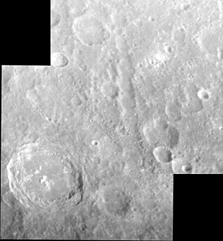
Haystack Catena is a catena on Mercury. It superficially resembles a graben but is a chain of overlapping secondary craters. It is named after Haystack Observatory, and was originally named Haystack Vallis when it was imaged by Mariner 10 in 1974, but the name was changed in 2013 to better reflect its origin. It is approximately 274 km long. It is located near the center of the Kuiper quadrangle, and it is radial to a large, unnamed crater that is Tolstojan in age.
Naskapi is an Algonquian language spoken by the Naskapi in Quebec and Labrador, Canada. It is written in Eastern Cree syllabics.

Korolev is an ice-filled impact crater in the Mare Boreum quadrangle of Mars, located at 73° north latitude and 165° east longitude. It is 81.4 kilometres (50.6 mi) in diameter and contains about 2,200 cubic kilometres (530 cu mi) of water ice, comparable in volume to Great Bear Lake in northern Canada. The crater was named after Sergei Korolev (1907–1966), the head Soviet rocket engineer and designer during the Space Race in the 1950s and 1960s.

Pangboche is a young impact crater on Mars, in the Tharsis quadrangle near the summit of Olympus Mons. It was named after a village in Nepal. It measures 10 kilometer in diameter, and is at 17.47° N and 133.4° W.
Poste Montagnais or Poste des Montagnais is the site of Hydro-Québec's electrical substation Poste Montagnais in the Côte-Nord region, approximately 12 km (7.5 mi) south of the border of Labrador. According to the Canadian Geographical Names Database, part of Natural Resources Canada, it is located in Lac-Jérôme, in the extreme western part of the Minganie Regional County Municipality but is in the Sept-Rivières Regional County Municipality.

McLaughlin Crater is an old crater in the Oxia Palus quadrangle of Mars, located at 21.9°N 337.63°E. It is 90.92 km (56.50 mi) in diameter and 2.2 km (1.4 mi) deep. The crater was named after Dean B. McLaughlin, an American astronomer (1901-1965). The Mars Reconnaissance Orbiter has found evidence that the water came from beneath the surface between 3.7 billion and 4 billion years ago and remained long enough to make carbonate-related clay minerals found in layers. McLaughlin Crater, one of the deepest craters on Mars, contains Mg-Fe clays and carbonates that probably formed in a groundwater-fed alkaline lake. This type of lake could have had a massive biosphere of microscopic organisms.
Old Montagnais is the period in the history of the Innu-aimun language preceding its current form.
Première Nation des Innus de Nutashkuan is an Innu First Nations band government in Quebec, Canada. The band lives on Nutashkuan, an Indian reserve in the Côte-Nord region. As of 2021, they have a registered population of 1,217 members. They are part of the Regroupement Mamit Innuat tribal council.
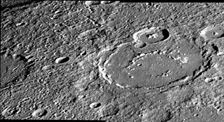
Larrocha is an impact crater on Mercury. It has a diameter of 196 km (122 mi), and it is one of 110 peak ring basins on Mercury. It is located in the Victoria quadrangle at 43.29°N 69.83°W.


