The Chicxulub crater is an impact crater buried underneath the Yucatán Peninsula in Mexico. Its center is offshore, but the crater is named after the onshore community of Chicxulub Pueblo. It was formed slightly over 66 million years ago when a large meteorite, about ten kilometers in diameter, struck Earth. The crater is estimated to be 200 kilometers in diameter and 20 kilometers in depth. It is the second largest confirmed impact structure on Earth, and the only one whose peak ring is intact and directly accessible for scientific research.
Bedout, or more specifically the Bedout High, is a geological and geophysical feature centered about 250 km off the northwestern coast of Australia in the Canning and overlying Roebuck basins. Although not obvious from sea floor topography, it is a roughly circular area about 30 km in diameter where older rocks have been uplifted as much as 4 km towards the surface and may mark the centre of a very large buried impact crater up to 250 km in diameter. The Bedout High was penetrated by two petroleum exploration wells in the 1970s and 1980s. It is named after nearby Bedout Island.

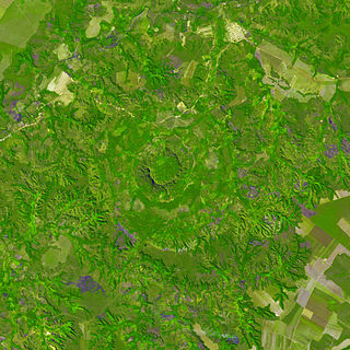
Acraman impact structure is a deeply eroded impact crater in the Gawler Ranges of South Australia. Its location is marked by Lake Acraman, a circular ephemeral playa lake about 20 kilometres (12 mi) in diameter. The discovery of the impact structure and independent discovery of its ejecta were first reported in the journal Science in 1986. The evidence for impact includes the presence of shatter cones and shocked quartz in shattered bedrock on islands within Lake Acraman.
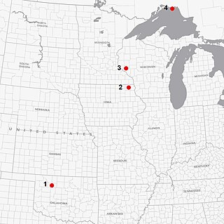
Ames crater is a meteorite crater (astrobleme) in Major County, Oklahoma, United States. Ames, Oklahoma is near the center of the structure, which is 30 miles (48 km) southwest of Enid, Oklahoma. Buried under a thick layer of sediment, it was not discovered until 1991. Subsequent drilling within the crater found a large amount of oil and gas. It is one of the largest of six meteor craters associated with oil-producing formations in the United States.
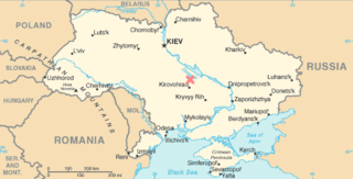
The Boltysh crater or Bovtyshka crater is a buried impact crater in the Kirovohrad Oblast of Ukraine, near the village of Bovtyshka. The crater is 24 kilometres (15 mi) in diameter and its age of 65.39 ± 0.14/0.16 million years, based on argon-argon dating techniques, less than 1 million years younger than Chicxulub crater in Mexico and the Cretaceous–Paleogene boundary. The Chicxulub impact is believed to have caused the mass extinction at the end of the Cretaceous period, which included the extinction of the non-avian dinosaurs. The Boltysh crater is currently thought to be unrelated to the Chicxulub impact, and to have not generated major global environmental effects.

Gosses Bluff is thought to be the eroded remnant of an impact crater. Known as Tnorala to the Western Arrernte people of the surrounding region, it is located in the southern Northern Territory, near the centre of Australia, about 175 km (109 mi) west of Alice Springs and about 212 km (132 mi) to the northeast of Uluru. It was named by Ernest Giles in 1872 after Australian explorer William Gosse's brother Henry, who was a member of William's expedition.
Kgagodi is an exposed meteorite crater in Botswana, roughly 7 kilometres south of the village of Kgagodi, where it got its name.

Mount Toondina crater is an impact structure, the eroded remnant of a former impact crater, located in northern South Australia in the locality of Allandale Station about 24 km (15 mi) south of the town of Oodnadatta. Mount Toondina is the high point of a circular topographic feature rising out of an otherwise relatively flat desert area of the Eromanga Basin. An impact origin was first suggested in 1976, challenging the earlier diapir hypothesis, and strongly supported by subsequent studies. A geophysical survey using gravity methods indicates an internal structure typical of complex impact craters, including an uplifted centre, and suggests that the original crater was about 3–4 km in diameter. The crater must be younger than the Early Cretaceous age of the rocks in which it is situated, but otherwise is not well dated. It has clearly undergone significant erosion since the impact event.
Obolon' crater is a 20 km (12 mi) diameter buried meteorite impact crater situated about 200 km (120 mi) southeast of Kyiv in Ukraine . The site has been drilled, which revealed the presence of shocked minerals and impact melt rock; the high chlorine content of the latter suggesting that the area was covered by shallow sea at the time of impact. One estimate puts the age at 169 ± 7 million years.
Red Wing or Red Wing Creek structure is a meteor crater located in McKenzie County, North Dakota, about 24 km (15 mi) southwest of Watford City, North Dakota, United States.
Viewfield is an impact crater in Saskatchewan, Canada. It is 2.5 kilometres (1.6 mi) in diameter and the age is estimated to be 190 ± 20 million years. The crater is not exposed at the surface.

Woodleigh is a large meteorite impact structure (astrobleme) in Western Australia, centred on Woodleigh Station east of Shark Bay, Gascoyne region. A team of four scientists at the Geological Survey of Western Australia and the Australian National University, led by Arthur J. Mory, announced the discovery in the 15 April 2000 issue of Earth and Planetary Science Letters.

Silverpit crater is a buried sub-sea structure under the North Sea off the coast of the island of Great Britain. The 20 km (12 mi) crater-like form, named after the Silver Pit—a nearby sea-floor valley recognized by generations of fishermen—was discovered during the routine analysis of seismic data collected during exploration for gas in the Southern North Sea Sedimentary Basin.
Serra da Cangalha is an impact crater in the State of Tocantins, near the border of Maranhão State, in north/northeastern Brazil. The crater is between 12 and 13 kilometres in diameter, making it the second-largest known crater in Brazil. Its age is estimated to be about 220 million years. The name means Pack-Saddle Mountains in Portuguese.
The Cooper Basin is a Permian-Triassic sedimentary geological basin in Australia. The intracratonic rift basin is located mainly in the southwestern part of Queensland and extends into northeastern South Australia. It is named after the Cooper Creek which is an ephemeral river that runs into Lake Eyre. For most of its extent, it is overlain by the Eromanga Basin. It covers 130,000 km2.
The Eromanga Basin is a large Mesozoic sedimentary basin in central and northern Australia. It covers parts of Queensland, the Northern Territory, South Australia, and New South Wales, and is a major component of the Great Artesian Basin. The Eromanga Basin covers 1,000,000 km2 and overlaps part of the Cooper Basin.
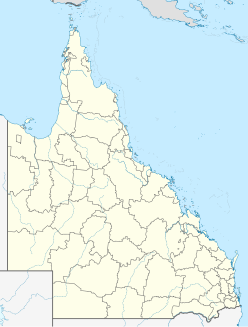
The Diamantina River ring feature is a geomorphic feature that consists of a conspicuous near-360° circular drainage pattern that forms the headwaters of the Diamantina River. It is centred near the Woodstock Station west of Winton, Channel Country, Central West Queensland. This geomorphic feature coincides with a potassium–thorium–uranium radiometric signature that is associated with exposed clay-rich sedimentary rocks of the Cretaceous Winton Formation, high-uranium elevated Cenozoic duricrust surfaces, and high-thorium elevated sediment eroded from the Cenozoic weathering profile. The Diamantina River ring feature is one of several circular crustal structures of diverse origin that have been mapped within Australia. These circular crustal structures include geologic structures such as tectonic domes, circular granite intrusions, volcanic calderas and ring structures, salt domes, impact structures and morphological drainage rings of unknown origin.
Praia Grande crater is a 20 kilometres (12 mi) diameter circular feature in the Santos Basin offshore Brazil. It is a possible impact crater that has been identified on 3D seismic by Petrobras in 2004. Further investigation is needed to obtain more information on the structure. The Russian Academy of Sciences lists the structure as a probable impact crater.