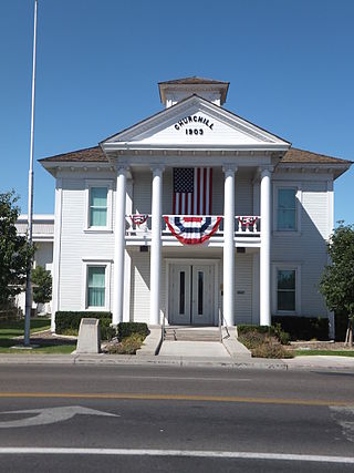
Churchill County is a county in the western U.S. state of Nevada. As of the 2020 census, the population was 25,516. Its county seat is Fallon. Named for Mexican–American War hero brevet Brigadier General Sylvester Churchill, the county was formed in 1861. Churchill County comprises the Fallon, NV Micropolitan Statistical Area. It is in northwestern Nevada. Churchill County is noteworthy in that it owns and operates the local telephone carrier, Churchill County Communications.

Stateline is a census-designated place (CDP) on the southeastern shore of Lake Tahoe in Douglas County, Nevada, United States. It lies next to the border with California and is conurbated with South Lake Tahoe. The population was 595 at the 2020 census. The population swells considerably during the busy winter and summer seasons, due to the high number of hotel rooms and rental accommodations available.
The Carson Range is a spur of the Sierra Nevada in eastern California and western Nevada that starts at Carson Pass and stretches north to the Truckee River near Verdi, Nevada.

The Carson River is a northwestern Nevada river that empties into the Carson Sink, an endorheic basin. The main stem of the river is 131 miles (211 km) long although the addition of the East Fork makes the total length 205 miles (330 km), traversing five counties: Alpine County in California and Douglas, Storey, Lyon, and Churchill Counties in Nevada, as well as the Consolidated Municipality of Carson City, Nevada. The river is named for Kit Carson, who guided John C. Frémont's expedition westward up the Carson Valley and across Carson Pass in winter, 1844. The river made the National Priorities List (NPL) on October 30, 1990 as the Carson River Mercury Superfund site (CRMS) due to investigations that showed trace amounts of mercury in the wildlife and watershed sediments.

Amargosa Valley is an unincorporated town located on U.S. Route 95 in Nye County, in the U.S. state of Nevada.
Woodfords is an unincorporated community in Alpine County, California, near Markleeville. For census purposes, it is included in Alpine Village. It is located 6 miles (9.7 km) north-northwest of Markleeville, at 38°46′40″N119°49′19″W.

State Route 88 (SR 88), also known as the Carson Pass Highway, is a state highway in the U.S. state of California. It travels in an east–west direction from Stockton, in the San Joaquin Valley, to the Nevada state line, where it becomes Nevada State Route 88, eventually terminating at U.S. Route 395 (US 395). The highway is so named as it crests the Sierra Nevada at Carson Pass. The highway corridor predates the era of the automobile; the path over Carson pass was previously used for the California Trail and the Mormon Emigrant Trail. The mountainous portion of the route is included in the State Scenic Highway System.

Mount Spokane State Park is a public recreation area in the northwest United States, located in the Selkirk Mountains, 23 miles (37 km) northeast of the city of Spokane, Washington. The state park surrounds 5,883-foot (1,793 m) Mount Spokane and other peaks including Mount Kit Carson, Beauty Mountain, and Quartz Mountain.

Benton is a census-designated place (CDP) in Mono County, California, United States. It includes the unincorporated communities of Benton and Benton Hot Springs and is 32 miles (51 km) north of the community of Bishop, at an elevation of 5,387 feet (1,642 m). The population of the CDP was 279 at the 2020 census.
Mount Baldy or Mount Baldy Village, formerly Camp Baynham and Camp Baldy, is an unincorporated community in the San Gabriel Mountains located in San Bernardino County and Los Angeles County in Southern California, with the county line running through the community. It is located below Mount San Antonio, commonly known as "Mount Baldy", hence its name.

Mount Mills is a Thirteener and California 4000 meter peak, on the Sierra Crest, north of Mount Abbot and south of Mono Pass in the Sierra Nevada.
The West Fork Carson River is a major tributary of the Carson River, about 35 miles (56 km) long, in Alpine County, California, and Douglas County, Nevada, in the United States.

The East Fork Carson River is the largest tributary of the Carson River, flowing through California and Nevada in the western United States. The north-flowing river is 61 miles (98 km) long and drains a mostly rural, mountainous watershed of 392 square miles (1,020 km2).
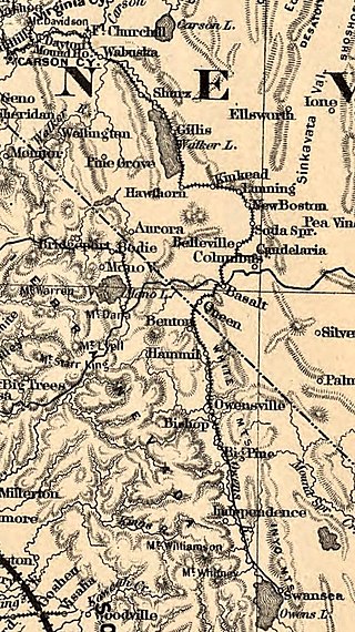
Basalt is a formerly populated place located in Mineral County, Nevada.
Jacobsville is a ghost town located in Lander County, Nevada, six miles west of Austin, on the east bank of Reese River, 0.7 mi N of US 50. Jacobsville was also known as Jacobs Spring, Jacobsville Station, Reese River and Reese River Station.

Mount Wood is a 12,657-foot-elevation (3,858 meter) mountain summit located just east of the crest of the Sierra Nevada mountain range, in Mono County of northern California, United States. It is situated in the Ansel Adams Wilderness, on land managed by Inyo National Forest. It is approximately 6.0 miles (9.7 km) northwest of the community of June Lake, two miles outside of Yosemite National Park's eastern boundary, and one mile east-southeast of line parent Parker Peak. Topographic relief is significant as the summit rises over 5,500 feet above Grant Lake in three miles. The mountain is visible from the June Lake Loop.

Mount Judah is an 8,243-foot-elevation (2,512 meter) mountain summit in Placer County, California, United States.
Mount Houghton is a 10,490-foot-elevation mountain summit located in Washoe County, Nevada, United States.


