Moody, Alabama

Last updated

Moody, Alabama
Moody City Hall - 2020.jpg
Moody Civic Center
Flag of Moody, Alabama.png
Moody Seal.png
Motto: 
Pursuing the Future Today
St. Clair County Alabama Incorporated and Unincorporated areas Moody Highlighted 0151096.svg
Location of Moody in St. Clair County
Coordinates: 33°35′33″N86°29′47″W / 33.59250°N 86.49639°W / 33.59250; -86.49639
Country United States
State Alabama
County St. Clair
Incorporated1962 [1]
Founded byConnor York
Government
  TypeMayor
  MayorJoe Lee (R)
Area
[2]
  Total24.84 sq mi (64.35 km2)
  Land24.53 sq mi (63.54 km2)
  Water0.31 sq mi (0.81 km2)
Elevation
692 ft (211 m)
Population
 (2020)
  Total13,170
  Density536.87/sq mi (207.28/km2)
Time zone UTC-6 (Central (CST))
  Summer (DST) UTC-5 (CDT)
ZIP code
35004
Area code(s) 205, 659
FIPS code 01-51096
GNIS feature ID0164758
Website www.moodyalabama.gov OOjs UI icon edit-ltr-progressive.svg

Moody is a city located in St. Clair County, Alabama. The city was founded in 1907, and it was named after a local businessman named Epps Moody. It is located about 22 miles (35 km) east of Birmingham and has a population of approximately 12,000 people. The city covers an area of 24.5 square miles, with a land area of 24.3 square miles and a water area of 0.2 square miles.

Contents

In the early days, the city was primarily an agricultural community, with cotton and timber being the main crops. However, with the arrival of the railroad in the early 20th century, Moody began to grow and develop into a more industrialized city. Today, the city is home to a number of industries, including manufacturing, healthcare, and retail.

The city hosts several events throughout the year, including the Moody Bluegrass Festival, which features live bluegrass music, arts and crafts, and food vendors. Other events include the Moody Miracle League Baseball Tournament, which raises money for the Miracle League of St. Clair County, and the Annual Christmas Parade.

Moody has a number of public and private schools. The Moody City School District operates two elementary schools, one middle school, and one high school. Additionally, there are several private schools in the area, including the Gathering Place Christian Academy [3] and Heritage Independent School. For higher education, the city is located near several colleges and universities, including the University of Alabama at Birmingham and Samford University. [4]

Geography

Moody is located at 33°35′33″N86°29′47″W / 33.59250°N 86.49639°W / 33.59250; -86.49639 (33.592469, -86.496369). [5]

According to the United States Census Bureau, the town has a total area of 24.0 square miles (62 km2), of which 23.9 square miles (62 km2) is land and 0.1 square miles (0.26 km2) (0.58%) is water.

The city is located east of Birmingham along Interstate 20, which runs through the southern part of the city. Access can be found from exits 144 and 147. Via I-20, downtown Birmingham is 22 mi (35 km) west, and Atlanta is 127 mi (204 km) east. U.S. Route 411 also passes through the city, leading northeast 23 mi (37 km) to Ashville and southwest 5 mi (8 km) to Leeds.

Demographics

Historical population
CensusPop.Note
1970 504
1980 1,840265.1%
1990 4,921167.4%
2000 8,05363.6%
2010 11,72645.6%
2020 13,17012.3%
U.S. Decennial Census [6]

2010 census

As of the 2010 census, there were 20,017 people, 5,816 households, and 344 families residing in the city. The population density was 834.04 inhabitants per square mile (322.02/km2). There were 3,317 housing units at an average density of 138.8 per square mile (53.6/km2). The racial makeup of the town was 94.09% White, 3.81% African American, 0.42% Native American, 0.22% Asian, 0.37% from other races, and 1.08% from two or more races. 1.09% of the population were Hispanic or Latino of any race.

There were 3,126 households, out of which 34.6% had children under the age of 18 living with them, 60.8% were married couples living together, 10.6% had a female householder with no husband present, and 25.1% were non-families. 22.2% of all households were made up of individuals, and 8.1% had someone living alone who was 65 years of age or older. The average household size was 2.58 and the average family size was 3.02.

In the town, the population was spread out, with 26.2% under the age of 18, 7.8% from 18 to 24, 31.6% from 25 to 44, 23.6% from 45 to 64, and 10.7% who were 65 years of age or older. The median age was 36 years. For every 100 females, there were 95.6 males. For every 100 females age 18 and over, there were 90.8 males.

The median income for a household in the town was $39,500, and the median income for a family was $43,767. Males had a median income of $38,150 versus $26,089 for females. The per capita income for the town was $18,208. About 12.0% of families and 12.6% of the population were below the poverty line, including 13.9% of those under age 18 and 12.2% of those age 65 or over.

2020 census

Moody racial composition [7]
RaceNum.Perc.
White (non-Hispanic)10,49879.71%
Black or African American (non-Hispanic)1,34210.19%
Native American 330.25%
Asian 2281.73%
Pacific Islander 30.02%
Other/Mixed 6254.75%
Hispanic or Latino 4413.35%

As of the 2020 United States census, there were 13,170 people, 4,930 households, and 3,516 families residing in the city.

Education

Public schools

Administered by the St. Clair County Board of Education: [4]

Private schools

Notable people

Related Research Articles

<span class="mw-page-title-main">Shelby County, Alabama</span> County in Alabama, United States

Shelby County is located in the central portion of the U.S. state of Alabama. As of the 2020 census the population was 223,024, making it the sixth-most populous county in Alabama. The county seat is Columbiana. Its largest city is Alabaster. The county is named in honor of Isaac Shelby, Governor of Kentucky from 1792 to 1796 and again from 1812 to 1816. Shelby County is included in the Birmingham–Hoover, AL Metropolitan Statistical Area.

<span class="mw-page-title-main">Talladega County, Alabama</span> County in Alabama, United States

Talladega County is one of the sixty-seven counties located in the east central portion of the U.S. state of Alabama. As of the 2020 census, the population was 82,149. Its county seat is Talladega.

<span class="mw-page-title-main">Oxford, Alabama</span> City in Alabama, United States

Oxford is a city in Calhoun, Talladega, and Cleburne counties in the State of Alabama, United States. The population was 22,069 at the 2020 census,. Oxford is one of two principal cities of and included in the Anniston-Oxford Metropolitan Statistical Area, and it is the largest city in Calhoun County by population.

<span class="mw-page-title-main">Heflin, Alabama</span> City in Alabama, United States

Heflin is a city and the county seat of Cleburne County, Alabama, United States. At the 2020 census, the population was 3,431. It is located approximately halfway between Birmingham and Atlanta along Interstate 20.

<span class="mw-page-title-main">Good Hope, Alabama</span> City in Alabama, United States

Good Hope is a city in Cullman County, Alabama, United States. As of the 2010 census, the population of the city was 2,264. It incorporated in April 1962.

<span class="mw-page-title-main">Eclectic, Alabama</span> Village in Alabama, United States

Eclectic is a town in Elmore County, Alabama, United States. It incorporated in 1907. At the 2020 census, the population was 1,193. It is part of the Montgomery Metropolitan Statistical Area.

<span class="mw-page-title-main">Attalla, Alabama</span> City in Alabama, United States

Attalla is a city in Etowah County, Alabama, United States. As of the 2010 census, the population was 6,048.

<span class="mw-page-title-main">Rainbow City, Alabama</span> City in Alabama, United States

Rainbow City is a city in Etowah County, Alabama, United States. It incorporated in 1950. The population was 9,602 at the 2010 census. It is part of the Gadsden Metropolitan Statistical Area.

<span class="mw-page-title-main">Center Point, Alabama</span> City in Alabama, United States

Center Point is a city and a former census-designated place (CDP) in northeastern Jefferson County, Alabama, United States. It is part of the Birmingham metropolitan area. At the 2020 census, the population was 16,406. However, after its incorporation in 2002, the city's boundaries are much smaller than those of the CDP. As of the 2010 census, the population of the incorporated city was 16,921. The public high school for Center Point is Center Point High School grades 9th-12th. The public middle school for Center Point is Erwin Middle School grades 6th-8th. Center Point has 2 public elementary schools, Erwin Intermediate School grades 3rd-5th and Center Point Elementary School grades K-2nd.

<span class="mw-page-title-main">Hartselle, Alabama</span> City in Alabama, United States

Hartselle is the second largest city in Morgan County, Alabama, United States, 13 miles (21 km) south of Decatur. It is part of the Decatur Metropolitan Area and the Huntsville-Decatur Combined Statistical Area.

<span class="mw-page-title-main">Roanoke, Alabama</span> City in Alabama, United States

Roanoke is a city in Randolph County, which is in the Piedmont region of eastern Alabama, United States. As of the 2020 census, the population of the city was 5,311, down from 6,074 in 2010 and 6,563 in 2000.

<span class="mw-page-title-main">Pelham, Alabama</span> City in Alabama, United States

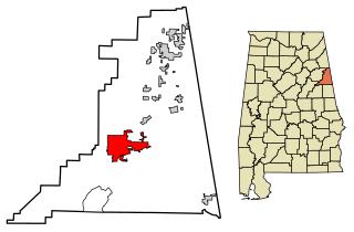
Pelham is a city in Shelby County, Alabama, United States. The population was 24,318 at the 2020 census, It incorporated on July 10, 1964 and is a suburb located in the Birmingham metropolitan area, Alabama which was home to nearly 1.2 million residents as of the 2020 census. It was named for Confederate Civil War officer John Pelham.

<span class="mw-page-title-main">Vincent, Alabama</span> City in Alabama, United States

Vincent, originally known as Propel, is a city in Shelby, St. Clair, and Talladega counties in the U.S. state of Alabama. At the 2020 census, the population was 1,982. The community was first known as Propel, but later named Vincent in honor of the Vincent family, who were early settlers of the area. It was incorporated in 1897.

<span class="mw-page-title-main">Ashville, Alabama</span> City in and county seat of St. Clair County, Alabama

Ashville is a city in and one of the county seats of St. Clair County, Alabama, United States, other seat being Pell City. Its population was 2,212 at the 2010 census, down from 2,260, at which time it was a town. It incorporated in 1822.

<span class="mw-page-title-main">Odenville, Alabama</span> Town in Alabama, United States

Odenville is a city in St. Clair County, Alabama, United States. It incorporated in 1914. At the 2010 census the population was 3,585, up from 1,131 in 2000. It annexed the former town of Branchville in 2007. Odenville annexed a portion of Springville in 2015 due to Springville not running water to some of its residences.

<span class="mw-page-title-main">Ragland, Alabama</span> Town in Alabama, United States

Ragland is a town in St. Clair County, Alabama, United States southeast of Ashville. It incorporated in 1899. At the 2020 census, the population was 1,693, up slightly from 1,639 in 2010. It is part of the Birmingham-Hoover-Cullman Combined Statistical Area.

<span class="mw-page-title-main">Riverside, Alabama</span> City in Alabama, United States

Riverside is a city in St. Clair County, Alabama, United States. It incorporated in 1886. At the 2010 census the population was 2,208, up from 1,564 in 2000.

<span class="mw-page-title-main">Lincoln, Alabama</span> City in Alabama, United States

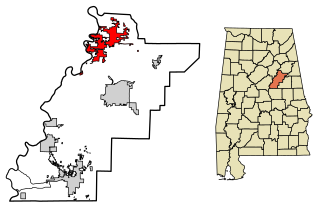
Lincoln is a city in Talladega County, Alabama, United States. It was incorporated in 1911. At the 2020 census, the population was 6,845. It was named for Major General Benjamin Lincoln, who served in the American army during the Revolutionary War.

<span class="mw-page-title-main">Talladega, Alabama</span> City in Alabama, United States

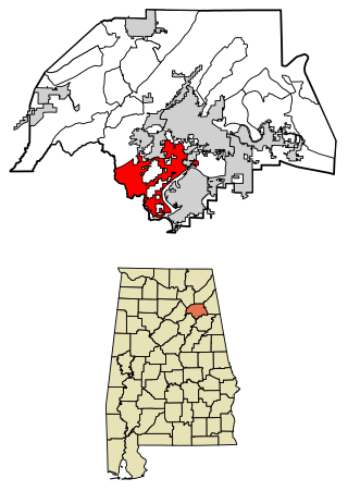
Talladega is the county seat of Talladega County, Alabama, United States. It was incorporated in 1835. At the 2020 census, the population was 15,861. Talladega is approximately 50 miles (80 km) east of one of the state’s largest cities, Birmingham.

<span class="mw-page-title-main">St. Clair County, Alabama</span> County in Alabama, United States

St. Clair County is a county located in the central portion of the U.S. state of Alabama. As of the 2020 census, the population was 91,103. It has two county seats: Ashville and Pell City. It is one of two counties in Alabama, and one of 33 in the United States, with more than one county seat. Its name is in honor of General Arthur St. Clair, an officer in the French and Indian War. St. Clair County is included in the Birmingham, Alabama Metropolitan Statistical Area.

References

  1. Kaetz, James P. (September 24, 2012). "Moody". Encyclopedia of Alabama . Retrieved May 12, 2022.
  2. "2020 U.S. Gazetteer Files". United States Census Bureau. Retrieved October 29, 2021.
  3. 1 2 "ABOUT". gpca.tv. Retrieved May 19, 2016.
  4. 1 2 "St. Clair County School District". www.sccboe.org. Retrieved May 19, 2016.
  5. "US Gazetteer files: 2010, 2000, and 1990". United States Census Bureau. February 12, 2011. Retrieved April 23, 2011.
  6. "U.S. Decennial Census". Census.gov. Retrieved June 6, 2013.
  7. "Explore Census Data". data.census.gov. Retrieved December 11, 2021.
  8. "FAQ". Crossroads Christian School. Retrieved May 19, 2016.
  9. Slade, Chad. "Chad Slade Bio - AuburnTigers.com - Official Athletics Site of the Auburn Tigers". auburntigers.com. Auburn Tigers . Retrieved June 12, 2015.