Odenville, Alabama

Last updated

Odenville, Alabama
St. Clair County Alabama Incorporated and Unincorporated areas Odenville Highlighted 0156400.svg
Location of Odenville in St. Clair County, Alabama.
Coordinates: 33°40′54″N86°23′57″W / 33.68167°N 86.39917°W / 33.68167; -86.39917
Country United States
State Alabama
County St. Clair
Area
[1]
  Total14.06 sq mi (36.42 km2)
  Land13.96 sq mi (36.17 km2)
  Water0.10 sq mi (0.25 km2)
Elevation
748 ft (228 m)
Population
 (2020)
  Total4,969
  Density355.82/sq mi (137.38/km2)
Time zone UTC-6 (Central (CST))
  Summer (DST) UTC-5 (CDT)
ZIP code
35120
Area code(s) 205, 659
FIPS code 01-56400
GNIS feature ID0164791
Website www.cityofodenville.net

Odenville is a city in St. Clair County, Alabama, United States. It incorporated in 1914. [2] At the 2010 census the population was 3,585, up from 1,131 in 2000. It annexed the former town of Branchville in 2007. Odenville annexed a portion of Springville in 2015 due to Springville not running water to some of its residences.

Contents

Geography

Odenville is located at 33°40′54″N86°23′57″W / 33.68167°N 86.39917°W / 33.68167; -86.39917 (33.681762, -86.399295). [3]

According to the U.S. Census Bureau, the town has a total area of 14.06 square miles (36.4 km2), all land.

Odenville is located in St. Clair County and is minutes away from the cities of Birmingham and Trussville. Highway 411 transverses the town.

Demographics

Historical population
CensusPop.Note
1920 375
1930 318−15.2%
1940 3479.1%
1950 302−13.0%
1960 300−0.7%
1970 53377.7%
1980 72435.8%
1990 7969.9%
2000 1,13142.1%
2010 3,585217.0%
2020 4,96938.6%
U.S. Decennial Census [4]
2013 Estimate [5]

2000 census

At the 2000 census there were 1,131 people, 421 households, and 333 families in the town. The population density was 348.3 inhabitants per square mile (134.5/km2). There were 459 housing units at an average density of 141.3 per square mile (54.6/km2). This figure is now much higher, but not yet recorded, due to a continued influx of population due to desirable location, affordable real-estate and good schools. The racial makeup of the town was 95.93% White, 1.95% Black or African American, 0.35% Native American, 0.35% from other races, and 1.41% from two or more races. 1.33% of the population were Hispanic or Latino of any race. [6] Of the 421 households 39.4% had children under the age of 18 living with them, 61.5% were married couples living together, 12.1% had a female householder with no husband present, and 20.9% were non-families. 19.5% of households were one person and 9.5% were one person aged 65 or older. The average household size was 2.69 and the average family size was 3.07.

The age distribution was 26.5% under the age of 18, 9.2% from 18 to 24, 30.7% from 25 to 44, 21.9% from 45 to 64, and 11.7% 65 or older. The median age was 35 years. For every 100 females, there were 92.5 males. For every 100 females age 18 and over, there were 92.8 males.

The median household income was $36,473 and the median family income was $40,694. Males had a median income of $31,429 versus $21,736 for females. The per capita income for the town was $17,330. About 5.0% of families and 5.9% of the population were below the poverty line, including 7.0% of those under age 18 and 10.5% of those age 65 or over.

70% were high school graduates or higher, and 7.2% had a bachelor's degree or higher.

2010 census

At the 2010 census there were 3,585 people, 1,341 households, and 1,033 families in the town. The population density was 1,120.3 inhabitants per square mile (432.6/km2). There were 1,476 housing units at an average density of 461.3 per square mile (178.1/km2). The racial makeup of the town was 94.2% White, 2.3% Black or African American, 0.3% Native American, 1.1% from other races, and 1.5% from two or more races. 2.1% of the population were Hispanic or Latino of any race. [7] Of the 1,341 households 31.6% had children under the age of 18 living with them, 61.1% were married couples living together, 10.6% had a female householder with no husband present, and 23.0% were non-families. 20.2% of households were one person and 7.2% were one person aged 65 or older. The average household size was 2.67 and the average family size was 3.06.

The age distribution was 24.7% under the age of 18, 8.8% from 18 to 24, 28.0% from 25 to 44, 26.3% from 45 to 64, and 12.1% 65 or older. The median age was 37.2 years. For every 100 females, there were 95.5 males. For every 100 females age 18 and over, there were 94.2 males.

The median household income was $53,936 and the median family income was $61,646. Males had a median income of $45,652 versus $31,875 for females. The per capita income for the town was $22,464. About 5.5% of families and 7.6% of the population were below the poverty line, including 5.4% of those under age 18 and 3.3% of those age 65 or over.

2020 census

Odenville racial composition [8]
RaceNum.Perc.
White (non-Hispanic)4,02581.0%
Black or African American (non-Hispanic)4569.18%
Native American 150.3%
Asian 210.42%
Other/Mixed 3056.14%
Hispanic or Latino 1472.96%

As of the 2020 United States census, there were 4,969 people, 1,381 households, and 1,124 families residing in the city.

Education


Odenville's school was called Walnut Grove after the name of the town. It was organized shortly after the Hardin and Vandergrift families settled in the area in 1821. The school was built around 1864 and was a log, one-room school building built in 1864. It was heated by a fireplace and was constructed near today's Pennington Garage. [9] Odenville has had other community schools in the area since the middle of the 19th century, including the Friendship School, Low Gap School and Branchville School. The first public Odenville School, a wooden structure established by Mr. Jim Hardin and Thay Bayer, burned in 1907. Jim Hardin's school bell is in the Fortson Museum, which is located next door to the Odenville Public Library today. Students had to meet in churches during construction of a new school. [10] [11] On July 18, 1908, the original St. Clair County High School building was constructed. A historic monument engraved with the names of the original county leaders responsible for the construction of this first high school stands in front of what is now Odenville Middle School.

Today Odenville Schools are a part of St. Clair County School District which include Odenville Elementary School, Odenville Intermediate School, Odenville Middle School, and St. Clair County High School. Margaret Elementary, located in the neighboring city of Margaret, AL feeds into St. Clair County Schools. Students may either attend Odenville Middle School and St. Clair County High School or Springville Middle School and Springville High School. [12]

Notable people

Related Research Articles

<span class="mw-page-title-main">Talladega County, Alabama</span> County in Alabama, United States

Talladega County is one of the sixty-seven counties located in the east central portion of the U.S. state of Alabama. As of the 2020 census, the population was 82,149. Its county seat is Talladega.

<span class="mw-page-title-main">Argo, Alabama</span> Town in Alabama, United States

Argo is a town in Jefferson and St. Clair counties, Alabama, United States. It incorporated in 1987. At the 2020 census, the population was 4,368.

<span class="mw-page-title-main">Center Point, Alabama</span> City in Alabama, United States

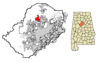
Center Point is a city and a former census-designated place (CDP) in northeastern Jefferson County, Alabama, United States. It is part of the Birmingham metropolitan area. At the 2020 census, the population was 16,406. However, after its incorporation in 2002, the city's boundaries are much smaller than those of the CDP. As of the 2010 census, the population of the incorporated city was 16,921. The public high school for Center Point is Center Point High School grades 9th-12th. The public middle school for Center Point is Erwin Middle School grades 6th-8th. Center Point has 2 public elementary schools, Erwin Intermediate School grades 3rd-5th and Center Point Elementary School grades K-2nd.

<span class="mw-page-title-main">Morris, Alabama</span> Town in Alabama, United States

Morris is a town in Jefferson County, Alabama, United States. It is north of the Birmingham suburb of Gardendale. It initially incorporated on September 19, 1885. At some point after 1910, its incorporation lapsed and it failed to appear on the census rolls beginning in 1920 through to 1950. It reincorporated on July 11, 1950. The population as of the 2020 U.S. Census was 2,259, up from 1,859 in 2010.

<span class="mw-page-title-main">Mount Olive, Jefferson County, Alabama</span> Unincorporated community in Alabama, United States

Mount Olive, also spelled Mt. Olive is an unincorporated community and a census-designated place (CDP) in Jefferson County, Alabama. Its location is in the suburbs of Birmingham. As of the 2010 census, the population of the community is 4,079. Mount Olive is bordered on the south and the east by the town of Gardendale, and in fact, some areas that had previously been in Mount Olive have been annexed into Gardendale over the years. Running along part of the border between Mt. Olive and Gardendale is the major expressway, Interstate 65. Eventually, part of Birmingham's Northern Beltline will cut through northwestern sections of Mt. Olive. Mt. Olive has its own elementary school, and was formerly the home of a junior high school.

<span class="mw-page-title-main">Vincent, Alabama</span> City in Alabama, United States

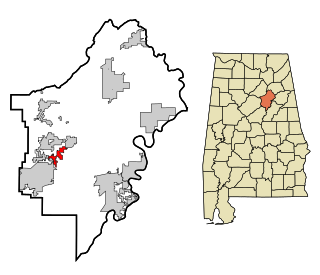
Vincent, originally known as Propel, is a city in Shelby, St. Clair, and Talladega counties in the U.S. state of Alabama. At the 2020 census, the population was 1,982. The community was first known as Propel, but later named Vincent in honor of the Vincent family, who were early settlers of the area. It was incorporated in 1897.

<span class="mw-page-title-main">Ashville, Alabama</span> City in and county seat of St. Clair County, Alabama

Ashville is a city in and one of the county seats of St. Clair County, Alabama, United States, other seat being Pell City. Its population was 2,212 at the 2010 census, down from 2,260, at which time it was a town. It incorporated in 1822.

<span class="mw-page-title-main">Branchville, Alabama</span> Town in Alabama, United States

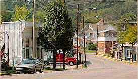
Branchville is a former town in St. Clair County, Alabama in the United States. As of the 2000 census, the population of the town was 825.

<span class="mw-page-title-main">Margaret, Alabama</span> City in Alabama, United States

Margaret is a city in St. Clair County, Alabama, United States. At the 2020 census, the population was 5,106. As of the 2010 census, the population is 4,428, an increase of 278.8%. Margaret incorporated in 1960 and became a city in October 2011.

<span class="mw-page-title-main">Moody, Alabama</span> City in Alabama

Moody is a city located in St. Clair County, Alabama. The city was founded in 1907, and it was named after a local businessman named Epps Moody. It is located about 22 miles east of Birmingham and has a population of approximately 12,000 people. The city covers an area of 24.5 square miles, with a land area of 24.3 square miles and a water area of 0.2 square miles.

<span class="mw-page-title-main">Ragland, Alabama</span> Town in Alabama, United States

Ragland is a town in St. Clair County, Alabama, United States southeast of Ashville. It incorporated in 1899. At the 2020 census, the population was 1,693, up slightly from 1,639 in 2010. It is part of the Birmingham-Hoover-Cullman Combined Statistical Area.

<span class="mw-page-title-main">Riverside, Alabama</span> City in Alabama, United States

Riverside is a city in St. Clair County, Alabama, United States. It incorporated in 1886. At the 2010 census the population was 2,208, up from 1,564 in 2000.

<span class="mw-page-title-main">Springville, Alabama</span> City in Alabama, United States

Springville is a city in St. Clair County, Alabama, United States. It incorporated in December 1880. At the 2020 census the population was 4,786, up from 4,080 in 2010.

<span class="mw-page-title-main">Fairview Heights, Illinois</span> City in Illinois, United States

Fairview Heights is a city in St. Clair County, Illinois, United States within Greater St. Louis. It is an eastern suburb of St. Louis. The population was 17,078 at the 2010 census. Fairview Heights is a dominant shopping center for Greater St. Louis and Southern Illinois and includes numerous shopping plazas and St. Clair Square mall.

<span class="mw-page-title-main">China Township, Michigan</span> Charter township in Michigan, United States

China Township is a charter township of St. Clair County in the U.S. state of Michigan. The population was 3,551 at the 2010 Census. It is named after China, Maine.

<span class="mw-page-title-main">St. Clair, Minnesota</span> City in Minnesota, United States

St. Clair or Saint Clair is a city in Blue Earth County, Minnesota, United States, located along the Le Sueur River. The population was 750 at the 2020 census. It is part of the Mankato-North Mankato Metropolitan Statistical Area.

<span class="mw-page-title-main">Saint Clair, Missouri</span> City in Missouri, United States

Saint Clair is a city in Franklin County, Missouri, United States. The population was 4,791 at the 2020 census.

<span class="mw-page-title-main">Bolivar, Missouri</span> City in Missouri, United States

Bolivar is a city and county seat of Polk County, Missouri, United States.

<span class="mw-page-title-main">Town and Country, Missouri</span> City in Missouri, United States

Town and Country is a city in west St. Louis County, Missouri, United States with a population of 11,640 as of the 2020 census. It is home to Missouri Baptist Medical Center,.

<span class="mw-page-title-main">St. Clair County, Alabama</span> County in Alabama, United States

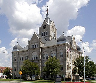
St. Clair County is a county located in the central portion of the U.S. state of Alabama. As of the 2020 census, the population was 91,103. It has two county seats: Ashville and Pell City. It is one of two counties in Alabama, and one of 33 in the United States, with more than one county seat. Its name is in honor of General Arthur St. Clair, an officer in the French and Indian War. St. Clair County is included in the Birmingham, Alabama Metropolitan Statistical Area.

References

  1. "2020 U.S. Gazetteer Files". United States Census Bureau. Retrieved October 29, 2021.
  2. "Odenville".
  3. "US Gazetteer files: 2010, 2000, and 1990". United States Census Bureau. February 12, 2011. Retrieved April 23, 2011.
  4. "U.S. Decennial Census". Census.gov. Retrieved June 6, 2013.
  5. "Annual Estimates of the Resident Population: April 1, 2010 to July 1, 2013" . Retrieved June 3, 2014.
  6. "U.S. Census website". United States Census Bureau . Retrieved January 31, 2008.
  7. "U.S. Census website". United States Census Bureau . Retrieved August 9, 2015.
  8. "Explore Census Data". data.census.gov. Retrieved December 11, 2021.
  9. https://discoverstclair.com/traveling-the-backroads/lost-schools-st-clair/
  10. https://discoverstclair.com/traveling-the-backroads/lost-schools-st-clair/
  11. https://cityofodenville.net/history
  12. https://www.sccboe.org

Heritage of St. Clair County, Page 38, Heritage Publishing Consultants Inc., P.O. Box 67, Clanton, Alabama, 35046.

33°40′54″N86°23′57″W / 33.681762°N 86.399295°W / 33.681762; -86.399295

[1]

[2]

[3]

  1. Joe Whitten (February 7, 2018). "Lost Schools of St. Clair". Discovery St. Clair. Discover, The Essence of St. Clair County, is a product of Partners by Design multimedia marketing. Retrieved April 24, 2023.
  2. unknown. "City of Odenville- History". City of Odenville. City of Odenville. Retrieved April 24, 2023.
  3. St. Clair County Schools. "St. Clair County Schools". St. Clair County Schools. Blackboard, Inc. Retrieved April 24, 2023.