
Sublette County is a county in the U.S. state of Wyoming. As of the 2010 United States Census, the population was 10,247. The county seat is Pinedale. It is a sparsely populated rural county in western Wyoming, along the Green River.

Bondurant is a census-designated place (CDP) in Sublette County, Wyoming, United States. The population was 93 at the 2010 census. The town was named after B. F. Bondurant.
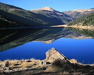
Pinedale is a town in and the county seat of Sublette County, Wyoming, United States. The population was 2,030 at the 2010 census. Pinedale is an important hunting outfitting town and a gateway to the Wind River Mountains. It is also a major gateway to the Jackson Hole area in Wyoming. Additionally, Pinedale is near several large natural gas fields, including the Pinedale Anticline and Jonah Field. Attractions include the Museum of the Mountain Man, Green River Rendezvous Days, White Pine Ski Area, and the Town Park System along the Pine Creek Corridor in the middle of town. The mayor is Matt Murdock, who was elected in 2018.
Jonah Field is a large natural gas field in the Green River Basin in Sublette County, Wyoming, in the United States. The field is approximately 32 miles (51 km) south of Pinedale and 65 miles (105 km) north of Rock Springs in southwestern Wyoming, and is estimated to contain 10.5 trillion cubic feet (300 km3) of natural gas. Managed by the Bureau of Land Management, the field has a productive area of 21,000 acres (8,500 ha).

Kern River Pipeline is a 1,679-mile (2,702 km) long natural gas pipeline line extending from southwestern Wyoming to its terminus near Bakersfield, California. The pipeline supplies local gas distribution companies, power plants, and heavy industry in Utah, Nevada, and California. It is owned and operated by the Kern River Gas Transmission Company, a subsidiary of Berkshire Hathaway Energy. Its FERC code is 99.

Pinedale is a previously unincorporated community in Fresno County, California. It lies at an elevation of 348 feet. It was once a rural community located on the Southern Pacific Railroad 3.5 miles (5.6 km) north-northwest of Clovis but has since become surrounded and annexed by the city of Fresno. Millerton Lake State Recreational Area is to its NE. The ZIP Code is 93650, and the community is inside area code 559.

Pinedale is an unincorporated community in Navajo County, Arizona, United States. The population was 487 at the 2010 census. The elevation is approximately 6,500 ft (2,000 m) and it is part of the Mogollon Rim mountain range.
Pinedale is an unincorporated community in McKinley County, New Mexico, United States.
There are two populated places in Alabama named Pinedale Shores:

Pinedale Shores, Alabama is a populated place in Marshall County. It is situated at 620 feet above mean sea level.
Wyoming Peak is the tallest mountain in the Wyoming Range in the U.S. state of Wyoming. Situated in Bridger-Teton National Forest, a now collapsed fire lookout is located on the summit. Wyoming Peak is .75 miles (1.21 km) south-southeast of Coffin Peak, the second highest peak in the Wyoming Range.
KPIN is a radio station broadcasting a country music format. Licensed to Pinedale, Wyoming, United States, the station serves the Pinedale area. As of 2013 the station is owned by Robert R. Rule.

The Minarets and Western Railway was a Class II common carrier that operated in Fresno County, California, from 1921 - 1933. The railway was owned by the Sugar Pine Lumber Company and was built the same year the lumber company was incorporated so that it could haul timber from the forest near Minarets to its sawmill at Pinedale. The southern portion of the line was operated with joint trackage rights with Southern Pacific.
The Bridger National Forest was first established by the U.S. Forest Service on July 1, 1911 in Wyoming with 577,580 acres (2,337.4 km2) from part of Bonneville National Forest. On May 14, 1923 Bridger was transferred Wyoming National Forest, and the name was discontinued. On March 10, 1943 Wyoming was renamed Bridger. In 1973 Bridger National Forest was administratively combined with Teton National Forest, creating Bridger-Teton National Forest. In descending order of land area, Bridger National Forest lands are located in Sublette, Lincoln, Fremont, and Teton counties. There are local ranger district offices in Afton, Big Piney, Kemmerer, and Pinedale. Its administrative headquarters reside in Jackson, Wyoming as part of the combined Bridger-Teton National Forest. Its current area of 1,736,075 acres represents 51.02% of the combined Bridger-Teton's area of 3,402,644 acres. The forest includes all of the National Wilderness Preservation System's officially designated Bridger Wilderness.

The Log Cabin Motel, also known as Camp O' The Pines in Pinedale, Wyoming, United States, was built in 1929 as a cabin camp to serve growing numbers of automobile-borne tourists bound for Yellowstone National Park. The camp was owned by Walter Scott, who operated the Pinedale Cash Store. Contrary to the name, Scott allowed customers to buy on credit, and some worked off their credit by building cabins at Camp O' The Pines. Unlike many auto camps, the camp was open year-round, with cabins often rented by the month by local people.
Sublette County School District #1 is a public school district based in Pinedale, Wyoming, United States.
The New Fork River is the uppermost major tributary of the Green River in Wyoming, flowing about 70 miles (110 km) entirely within Sublette County. It drains an arid farming region of southwestern Wyoming south of the Wind River Range.

News Media Corporation (NMC) is a newspaper corporation that was founded in 1975 by John C. Tompkins. It publishes 65 different newspaper titles in eight states across the United States. Currently, it operates in smaller cities and towns with populations between 5,000 and 50,000. In 2012, NMC created a new strategic business unit called News Media Digital, which is responsible for the organization's digital marketing and advertising ventures.

The Trappers Point Site is an archaeological site located near Pinedale, Wyoming. The site, which dates to the Early Archaic period, is the oldest known location used for the mass killing of pronghorn antelope. In addition, a large number of projectile points have been found at the site; the variety of projectile point designs at the site have helped establish how these tools developed, and the presence of points from many parts of the Green River valley have aided in determining prehistoric migration patterns. The site has been called "a major discovery in Wyoming archaeology" and "one of the key sites in Wyoming".


