Morrison, Colorado

Last updated

Morrison, Colorado
Overlooking Morrison.JPG
Town of Morrison with Red Rocks Amphitheatre in background
Motto: 
The Nearest Faraway Place
Jefferson County Colorado Incorporated and Unincorporated areas Morrison Highlighted 0852075.svg
Location of Morrison in Jefferson County, Colorado
Coordinates: 39°39′6″N105°11′25″W / 39.65167°N 105.19028°W / 39.65167; -105.19028
Country Flag of the United States (23px).png  United States
State Flag of Colorado.svg  Colorado
County Jefferson County [1]
Incorporated January 29, 1906 [2]
Government
  Type Home rule municipality [1]
   Mayor Chris Wolfe
Area
[3]
  Total2.2 sq mi (4.24 km2)
  Land2.2 sq mi (4.23 km2)
  Water0.00 sq mi (0.01 km2)
Elevation
[4]
5,764 ft (1,757 m)
Population
 (2020) [5]
  Total396
  Density180/sq mi (93/km2)
Time zone UTC-7 (MST)
  Summer (DST) UTC-6 (MDT)
ZIP code [6]
80465
Area code(s) Both 303 and 720
FIPS code 08-52075
GNIS feature ID 0182140
Website www.morrisonco.us

Morrison is a home rule municipality in Jefferson County, Colorado, United States. The population was 396 at the 2020 census. [5]

Contents

History

This small foothills settlement is named after George Morrison (April 16, 1822 – June 11, 1895), a builder and businessman who left a mark not only on the town that now bears his name, but on the history of the area. A stonemason who immigrated from Canada to the Mt. Vernon area in 1859, he helped found the town of Mt. Vernon and built the Mt. Vernon House, seat of the territorial government under Robert Steele, and an important stop for travelers on the Mt. Vernon Toll Road from Denver to the goldfields of the Rocky Mountains. He became a U.S. citizen on May 22, 1862. [7] George Morrison later moved south to Bear Creek, where he founded the Morrison Stone, Lime, and Town Co., and in 1874 platted the town that became known as Morrison, or briefly as Mt. Morrison. With Gov. John Evans, he was instrumental in bringing the Denver, South Park and Pacific Railroad to Morrison in 1874.

As a quarryman, Morrison developed the building stone and other industrial stone (lime, gypsum) of the Morrison/Mt. Vernon area, bringing fame to the region for its high-quality dimension stone. Two of the three stone buildings he built in Morrison, as well as the Mt. Vernon House further north, are still standing; all three surviving buildings are recognized historic sites (National Register of Historic Places, 1976). Before its demolition in 1982, the original Evergreen Hotel, built by George Morrison in 1874, served as the first home of Sacred Heart College (now Regis University), and later as the Mt. Morrison Casino, where John Brisben Walker entertained many of the dignitaries he brought to the foothills as part of his promotional enterprises. The Morrison Schoolhouse he built served the town's educational needs from its construction in 1875 until 1955, and stands today as a private residence. The Cliff House, built as the Morrison family home in 1873, now provides guest lodging.

These landmarks represent a distinctive style of construction and are enduring monuments to George Morrison's contributions to Jefferson County's history. Stone for these structures was quarried in his "red sandstone quarry" at the end of the Dakota Hogback near Morrison. Building stone was also shipped to Denver, where it now comprises parts of the Brown Palace Hotel, Union Station, and "many of Denver's early day mansions". [7]

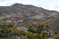
Mount Morrison behind Red Rocks Park is also named after George Morrison. In the late 1800s, an important regional geologic layer of Late Jurassic age, the Morrison Formation, was named after the town of Morrison, and is today famous as the first discovery site of three 150-million-year-old dinosaurs, Apatosaurus , Diplodocus , and the Colorado state fossil, Stegosaurus . The Morrison Formation covers parts of thirteen western states and has yielded much of our understanding of the extinct animals that lived in the West so long ago.

Dinosaur discoveries

In 1877, the holotypic remains of the dinosaurs Stegosaurus armatus and Apatosaurus ajax were discovered near Morrison by Arthur Lakes. The majority of these fossils were shipped to Othniel Charles Marsh at Yale's Peabody Museum of Natural History in New Haven, Connecticut. These finds from the Morrison area figured in the 19th century "Bone Wars" between rival paleontologists Marsh and Edward Drinker Cope.

In 1896, the Late Jurassic section of sedimentary rock excavated by Lakes was formally named the Morrison Formation for the town near the prominent outcrops where it was described (Eldridge, 1896). In 1944, a type locality was designated at the roadcut along the north side of W. Alameda Parkway, 2 miles (3 km) north of Morrison, in SE/4 sec. 23, T. 4 S., R. 70 W. (Waldschmidt and LeRoy, 1944). [8]

The Morrison Natural History Museum houses and displays some fossils found by Lakes, and museum staff have begun reworking Lakes' original digs at Quarry 10. In 2006, the MNHM reported rare adult Stegosaurus tracks from the Morrison area. A year later the first hatchling Stegosaurus tracks were reported. These fossils are on display at the museum. [9]

Cretaceous-age dinosaur tracks and one of Lakes' historic dig sites can still be viewed on what is now known as Dinosaur Ridge east of Morrison.

Also located near Morrison is a significant archaeological site; known as the LoDaisKa site, it was inhabited for approximately 7,500 years. [10]

20th century

The Town of Morrison was officially incorporated following a unanimous election on January 9, 1906. Sixty-nine votes were cast. On February 13, 1906, a second election gave the newly created town a board of trustees. The first mayor was Thomas Cowan Morrison, son of the town's founder. The original trustees were Dr. Frank L. Luce, Charles Pike, Jacob Schneider, J.W. McLean, Peter O. Nelson, and Lawrence E. "Lee" LaGrow. Most of those names are well recognized as pioneers in Morrison's history. The new board held its first meeting on February 14, 1906. [11]

Morrison's first ordinances were passed in February and March 1906, as the original board began the process of managing the town's affairs. The first set a fiscal year beginning March 1, directed the clerk to certify valuation and the board to levy taxes based thereon, and directed the town treasurer to collect funds from the county treasurer. [11]

Pete Morrison, grandson of the town's founder and son of the first mayor, achieved fame during the early 1900s as a cowboy star in silent film, and ultimately had his own studio, Lariat Productions, in Hollywood. [12]

In 1976, the Morrison Historic District was listed on the National Register of Historic Places.

Geography

Morrison is located at 39°39′6″N105°11′25″W / 39.65167°N 105.19028°W / 39.65167; -105.19028 (39.651764, -105.190344). [13] According to the United States Census Bureau, the town has a total area of 2.2 square miles (5.7 km2), all of it land. Morrison is southwest of Denver and is located on State Highway 470 and Morrison Road.

The Morrison postal ZIP code (80465) extends west up Turkey Creek Canyon and south of the town. [14] It thus applies to an area covering approximately 5,000 addresses. Because the Morrison Post Office serves this large area beyond the town boundaries proper, many events and people connected with "Morrison" are actually in unincorporated portions of Jefferson County.

Demographics

Historical population
CensusPop.Note
1880 186
1890 25436.6%
1910 251
1920 195−22.3%
1930 177−9.2%
1940 21622.0%
1950 30641.7%
1960 42639.2%
1970 4393.1%
1980 4788.9%
1990 465−2.7%
2000 430−7.5%
2010 428−0.5%
2020 396−7.5%
U.S. Decennial Census

Government

The local government features a mayor, town manager and a board of trustees.

The town is infamous as a speed trap. Press reports indicate that about half the town's $2.6 million budget comes from traffic fines. More than 90% of police activity is issuing speeding tickets. [15]

Notable people

See also

Related Research Articles

<i>Apatosaurus</i> Sauropod dinosaur genus from Late Jurassic period

Apatosaurus is a genus of herbivorous sauropod dinosaur that lived in North America during the Late Jurassic period. Othniel Charles Marsh described and named the first-known species, A. ajax, in 1877, and a second species, A. louisae, was discovered and named by William H. Holland in 1916. Apatosaurus lived about 152 to 151 million years ago (mya), during the late Kimmeridgian to early Tithonian age, and are now known from fossils in the Morrison Formation of modern-day Colorado, Oklahoma, New Mexico, Wyoming, and Utah in the United States. Apatosaurus had an average length of 21–23 m (69–75 ft), and an average mass of 16.4–22.4 t. A few specimens indicate a maximum length of 11–30% greater than average and a mass of approximately 33 t.

<span class="mw-page-title-main">West Pleasant View, Colorado</span> Census Designated Place in Colorado, United States

West Pleasant View is an unincorporated community and a census-designated place (CDP) located in and governed by Jefferson County, Colorado, United States. The CDP is a part of the Denver–Aurora–Lakewood, CO Metropolitan Statistical Area. The population of the West Pleasant View CDP was 4,327 at the United States Census 2020. The Pleasant View Metropolitan District provides services. The Golden post office serves the area.

<i>Stegosaurus</i> Thyreophoran stegosaurid dinosaur genus from Late Jurassic period

Stegosaurus is a genus of herbivorous, four-legged, armored dinosaur from the Late Jurassic, characterized by the distinctive kite-shaped upright plates along their backs and spikes on their tails. Fossils of the genus have been found in the western United States and in Portugal, where they are found in Kimmeridgian- to Tithonian-aged strata, dating to between 155 and 145 million years ago. Of the species that have been classified in the upper Morrison Formation of the western US, only three are universally recognized: S. stenops, S. ungulatus and S. sulcatus. The remains of over 80 individual animals of this genus have been found. Stegosaurus would have lived alongside dinosaurs such as Apatosaurus, Diplodocus, Camarasaurus and Allosaurus, the latter of which may have preyed on it.

<span class="mw-page-title-main">Dinosaur National Monument</span> National monument in Colorado and Utah, United States

Dinosaur National Monument is an American national monument located on the southeast flank of the Uinta Mountains on the border between Colorado and Utah at the confluence of the Green and Yampa rivers. Although most of the monument area is in Moffat County, Colorado, the Dinosaur Quarry is located in Utah, north of the town of Jensen, Utah. The nearest Colorado town is Dinosaur while the nearest city is Vernal, Utah.

<span class="mw-page-title-main">Morrison Formation</span> Rock formation in the western United States

The Morrison Formation is a distinctive sequence of Upper Jurassic sedimentary rock found in the western United States which has been the most fertile source of dinosaur fossils in North America. It is composed of mudstone, sandstone, siltstone, and limestone and is light gray, greenish gray, or red. Most of the fossils occur in the green siltstone beds and lower sandstones, relics of the rivers and floodplains of the Jurassic period.

<span class="mw-page-title-main">Como Bluff</span> United States historic place

Como Bluff is a long ridge extending east–west, located between the towns of Rock River and Medicine Bow, Wyoming. The ridge is an anticline, formed as a result of compressional geological folding. Three geological formations, the Sundance, the Morrison, and the Cloverly Formations, containing fossil remains from the Late Jurassic of the Mesozoic Era are exposed.

<i>Marshosaurus</i> Extinct genus of dinosaurs

Marshosaurus is a genus of medium-sized carnivorous theropod dinosaur, belonging to the family Piatnitzkysauridae, from the Late Jurassic Morrison Formation of Utah and possibly Colorado.

Arthur Lakes was an American geologist, artist, writer, teacher and Episcopalian minister. He captured much of his geological and palaeontological field work in sketches and watercolours. Lakes is credited with successfully deciphering much of the geology of Colorado and, as an economic geologist, guiding mineral exploration which was so important to the State.

<span class="mw-page-title-main">Dry Mesa Quarry</span>

The Dry Mesa Dinosaur Quarry is situated in southwestern Colorado, United States, near the town of Delta. Its geology forms a part of the Morrison Formation and has famously yielded a great diversity of animal remains from the Jurassic Period, among them Ceratosaurus, Supersaurus, and Torvosaurus. The quarry is found within the Uncompahgre National Forest.

<span class="mw-page-title-main">Garden Park, Colorado</span> Paleontological site

Garden Park is a paleontological site in Fremont County, Colorado, known for its Jurassic dinosaurs and the role the specimens played in the infamous Bone Wars of the late 19th century. Located 10 km (6.2 mi) north of Cañon City, the name originates from the area providing vegetables to the miners at nearby Cripple Creek in the 19th century. Garden Park proper is a triangular valley surrounded by cliffs on the southeast and southwest and by mountains to the north; however, the name is also refers to the dinosaur sites on top and along the cliffs. The dinosaur sites now form the Garden Park Paleontological Resource Area, which is overseen by the Bureau of Land Management.

<span class="mw-page-title-main">Lariat Loop Scenic and Historic Byway</span> Colorado Scenic and Historic Byway

The Lariat Loop National Scenic and Historic Byway is a National Scenic Byway and a Colorado Scenic and Historic Byway located in Jefferson County, Colorado, USA. The byway is a 40-mile (64 km) loop in the Front Range foothills west of Denver through Golden, Lookout Mountain Park, Genesee Park, Evergreen, Morrison, Red Rocks Park, and Dinosaur Ridge. The Lariat Loop connects to the Mount Evans Scenic Byway at Bergen Park.

<span class="mw-page-title-main">Index of Colorado-related articles</span>

This is an alphabetical list of articles related to the U.S. State of Colorado.

<span class="mw-page-title-main">Dinosaur Ridge</span> Natural heritage site in Colorado, United States

Dinosaur Ridge is a segment of the Dakota Hogback in the Morrison Fossil Area National Natural Landmark located in Jefferson County, Colorado, near the town of Morrison and just west of Denver.

<span class="mw-page-title-main">LoDaisKa site</span> Archaeological site in Colorado, United States

The LoDaisKa site is a prominent archaeological site in the U.S. state of Colorado, located within a rockshelter near Morrison. The rockshelter was first inhabited by people of the Archaic through the Middle Ceramic period, generally spanning 3000 BC to 1000 AD.

<span class="mw-page-title-main">Paleontology in Colorado</span> Paleontological research in the U.S. state of Colorado

Paleontology in Colorado refers to paleontological research occurring within or conducted by people from the U.S. state of Colorado. The geologic column of Colorado spans about one third of Earth's history. Fossils can be found almost everywhere in the state but are not evenly distributed among all the ages of the state's rocks. During the early Paleozoic, Colorado was covered by a warm shallow sea that would come to be home to creatures like brachiopods, conodonts, ostracoderms, sharks and trilobites. This sea withdrew from the state between the Silurian and early Devonian leaving a gap in the local rock record. It returned during the Carboniferous. Areas of the state not submerged were richly vegetated and inhabited by amphibians that left behind footprints that would later fossilize. During the Permian, the sea withdrew and alluvial fans and sand dunes spread across the state. Many trace fossils are known from these deposits.

<span class="mw-page-title-main">Paleontology in Utah</span> Paleontological research in Utah

Paleontology in Utah refers to paleontological research occurring within or conducted by people from the U.S. state of Utah. Utah has a rich fossil record spanning almost all of the geologic column. During the Precambrian, the area of northeastern Utah now occupied by the Uinta Mountains was a shallow sea which was home to simple microorganisms. During the early Paleozoic Utah was still largely covered in seawater. The state's Paleozoic seas would come to be home to creatures like brachiopods, fishes, and trilobites. During the Permian the state came to resemble the Sahara desert and was home to amphibians, early relatives of mammals, and reptiles. During the Triassic about half of the state was covered by a sea home to creatures like the cephalopod Meekoceras, while dinosaurs whose footprints would later fossilize roamed the forests on land. Sand dunes returned during the Early Jurassic. During the Cretaceous the state was covered by the sea for the last time. The sea gave way to a complex of lakes during the Cenozoic era. Later, these lakes dissipated and the state was home to short-faced bears, bison, musk oxen, saber teeth, and giant ground sloths. Local Native Americans devised myths to explain fossils. Formally trained scientists have been aware of local fossils since at least the late 19th century. Major local finds include the bonebeds of Dinosaur National Monument. The Jurassic dinosaur Allosaurus fragilis is the Utah state fossil.

<span class="mw-page-title-main">Paleontology in the United States</span>

Paleontology in the United States refers to paleontological research occurring within or conducted by people from the United States. Paleontologists have found that at the start of the Paleozoic era, what is now "North" America was actually in the southern hemisphere. Marine life flourished in the country's many seas. Later the seas were largely replaced by swamps, home to amphibians and early reptiles. When the continents had assembled into Pangaea drier conditions prevailed. The evolutionary precursors to mammals dominated the country until a mass extinction event ended their reign.

<span class="mw-page-title-main">History of paleontology in the United States</span>

The history of paleontology in the United States refers to the developments and discoveries regarding fossils found within or by people from the United States of America. Local paleontology began informally with Native Americans, who have been familiar with fossils for thousands of years. They both told myths about them and applied them to practical purposes. African slaves also contributed their knowledge; the first reasonably accurate recorded identification of vertebrate fossils in the new world was made by slaves on a South Carolina plantation who recognized the elephant affinities of mammoth molars uncovered there in 1725. The first major fossil discovery to attract the attention of formally trained scientists were the Ice Age fossils of Kentucky's Big Bone Lick. These fossils were studied by eminent intellectuals like France's George Cuvier and local statesmen and frontiersman like Daniel Boone, Benjamin Franklin, William Henry Harrison, Thomas Jefferson, and George Washington. By the end of the 18th century possible dinosaur fossils had already been found.

<span class="mw-page-title-main">Bear Creek (Colorado)</span> River

Bear Creek is a tributary of the South Platte River in central Colorado in the United States. It begins as a small creek up in the Mount Blue Sky Wilderness in Summit Lake and makes its way through Evergreen, CO, Kittredge, CO, Idledale, CO and Morrison, CO before entering Bear Creek Lake Park, managed by the City of Lakewood, Colorado.

References

  1. 1 2 "Active Colorado Municipalities". State of Colorado, Department of Local Affairs. Archived from the original on December 12, 2009. Retrieved September 1, 2007.
  2. "Colorado Municipal Incorporations". State of Colorado, Department of Personnel & Administration, Colorado State Archives. December 1, 2004. Retrieved September 2, 2007.
  3. "2019 U.S. Gazetteer Files". United States Census Bureau. Retrieved July 1, 2020.
  4. "US Board on Geographic Names". United States Geological Survey. October 25, 2007. Retrieved January 31, 2008.
  5. 1 2 United States Census Bureau. "Morrison town; Colorado" . Retrieved April 23, 2023.
  6. "ZIP Code Lookup". United States Postal Service. Archived from the original (JavaScript/HTML) on November 4, 2010. Retrieved November 25, 2007.
  7. 1 2 Brown, Georgina. 1976. Shining Mountains. Library of Congress catalog # 75-41547, 248 p. (Index compiled by Ginna C. Snyder, Foothills Genealogical Society of Colorado, Inc., 1985.)
  8. USGS GEOLEX Name Summary. Accessed October 13, 2011.
  9. Morrison Natural History Museum website Archived December 28, 2011, at the Wayback Machine , accessed 2011.12.28.
  10. Jefferson County Archived November 21, 2010, at the Wayback Machine , Colorado Historical Society Office of Archaeology & Historic Preservation, n.d. Accessed February 15, 2011.
  11. 1 2 White, S.L. 2005. Morrison's Second Centennial. Pages 9-13, in Historically Jeffco magazine. Jefferson Co. Historical Commission.
  12. Cowboy Pete: Film Pioneer, by Edna Fiore Accessed October 13, 2011.
  13. "US Gazetteer files: 2010, 2000, and 1990". United States Census Bureau. February 12, 2011. Retrieved April 23, 2011.
  14. Zip code map of Jefferson County at City & Mountain Views magazine, retrieved December 28, 2011.
  15. Sallinger, Marc (October 20, 2021). "Morrison PD chief resigns days after conceding ticket revenue would fall $800K short of expectations". KUSA.