Denver is the central city of a conurbation region in the U.S. state of Colorado. The conurbation includes one continuous region consisting of the six central counties of Adams, Arapahoe, Broomfield, Denver, Douglas, and Jefferson. The Denver region is part of the Front Range Urban Corridor and its metropolitan planning organization is the Denver Regional Council of Governments.

Jefferson County is a county located in the U.S. state of Colorado. As of the 2020 census, the population was 582,910, making it the fourth-most populous county in Colorado. The county seat is Golden, and the most populous city's Lakewood.

Arapahoe County is a county located in the U.S. state of Colorado. As of the 2020 census, its population was 655,070, making it the third-most populous county in Colorado. The county seat is Littleton, and the most populous city is Aurora. The county was named for the Arapaho Native American tribe, who once lived in the region.
Applewood is an unincorporated community and a census-designated place (CDP) located in and governed by Jefferson County, Colorado, United States. The CDP is a part of the Denver–Aurora–Lakewood, CO Metropolitan Statistical Area. The population of the Applewood CDP was 7,833 at the 2020 United States Census. The Golden post office serves the area.

Aspen Park is an unincorporated community and a census-designated place (CDP) located in Jefferson County, Colorado, United States. The CDP is a part of the Denver–Aurora–Lakewood, CO Metropolitan Statistical Area. The population of the Aspen Park CDP was 810 at the United States Census 2020. The Aspen Park Metropolitan District provides services. The Conifer post office serves the area.

Evergreen is an unincorporated town, a post office, and a census-designated place (CDP) located in and governed by Jefferson County, Colorado, U.S. The CDP is a part of the Denver–Aurora–Lakewood, CO Metropolitan Statistical Area. The Evergreen post office has the ZIP Codes 80439 and 80437. At the 2020 census, the population of the Evergreen CDP was 9,307. The Evergreen Metropolitan District provides services.

Indian Hills is an unincorporated town, a post office, and a census-designated place (CDP) located in and governed by Jefferson County, Colorado, United States. The CDP is a part of the Denver–Aurora–Lakewood, CO Metropolitan Statistical Area. The Indian Hills post office has the ZIP code 80454. At the United States Census 2020, the population of the Indian Hills CDP was 1,474.

Ken Caryl, commonly known as Ken Caryl Ranch, is an unincorporated community and a census-designated place (CDP) located in and governed by Jefferson County, Colorado, United States. The CDP is a part of the Denver–Aurora–Lakewood, CO Metropolitan Statistical Area. The population of the Ken Caryl CDP was 33,811 at the 2020 census. The Ken Caryl Ranch Metropolitan District and the Ken Caryl Ranch Water District provide services. The Littleton post office serves the area.

Kittredge is an unincorporated town, a post office, and a census-designated place (CDP) located in and governed by Jefferson County, Colorado, United States. The CDP is a part of the Denver–Aurora–Lakewood, CO Metropolitan Statistical Area. The Kittredge post office has the ZIP code 80457. At the United States Census 2020, the population of the Kittredge CDP was 1,308.
East Pleasant View is an unincorporated community and a census-designated place (CDP) located in and governed by Jefferson County, Colorado, United States. The CDP is a part of the Denver–Aurora–Lakewood, CO Metropolitan Statistical Area. The population of the East Pleasant View CDP was 333 at the United States Census 2020. The Pleasant View Metropolitan District provides services. The Golden Post Office serves the area.

West Pleasant View is an unincorporated community and a census-designated place (CDP) located in and governed by Jefferson County, Colorado, United States. The CDP is a part of the Denver–Aurora–Lakewood, CO Metropolitan Statistical Area. The population of the West Pleasant View CDP was 4,327 at the United States Census 2020. The Pleasant View Metropolitan District provides services. The Golden post office serves the area.

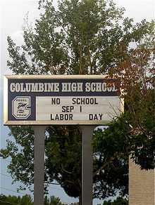
Columbine High School (CHS) is a public high school in Columbine, Colorado, United States, in the Denver metropolitan area. It is part of the Jefferson County Public Schools district.

Centennial is a home rule municipality located in Arapahoe County, Colorado, United States. The city population was 108,418 at the 2020 United States Census, making Centennial the 11th most populous municipality in Colorado. Centennial is a part of the Denver–Aurora–Lakewood, CO Metropolitan Statistical Area and the Front Range Urban Corridor.
Chatfield High School is a high school located in Ken Caryl, an unincorporated area of Jefferson County near Littleton, Colorado, United States. It is part of the Jefferson County Public Schools system.

Colorado's 6th congressional district is a congressional district in the U.S. state of Colorado. Located in central Colorado, the district encompasses much of the eastern part of the Denver metropolitan area, including all of Aurora, as well as portions of the southern and northern metro area.

Littleton is a home rule municipality city located in Arapahoe, Douglas, and Jefferson counties, Colorado, United States. Littleton is the county seat of Arapahoe County and is a part of the Denver–Aurora–Lakewood, CO Metropolitan Statistical Area. The city population was 45,652 at the 2020 United States Census, ranking as the 20th most populous municipality in the State of Colorado.

Idledale is an unincorporated town, a post office, and a census-designated place (CDP) located in and governed by Jefferson County, Colorado, United States. The CDP is a part of the Denver–Aurora–Lakewood, CO Metropolitan Statistical Area. The Idledale post office has the ZIP code 80453. At the United States Census 2020, the population of the Idledale CDP was 244.
Dakota Ridge Senior High School is a public school located in Littleton, Colorado, United States. It is part of the Jefferson County Public Schools system.

Dakota Ridge is an unincorporated community and a census-designated place (CDP) located in and governed by Jefferson County, Colorado, United States. The CDP is a part of the Denver–Aurora–Lakewood, CO Metropolitan Statistical Area. The population of the Dakota Ridge CDP was 33,892 at the United States Census 2020. In 1988, voters turned down a proposal to incorporate Dakota Ridge. The community lies in ZIP codes 80127 and 80465.

Fairmount is an unincorporated community and a census-designated place (CDP) in Jefferson County, Colorado, United States. The CDP is a part of the Denver–Aurora–Lakewood, CO Metropolitan Statistical Area. The population of the Fairmount CDP was 9,324 at the United States Census 2010. ZIP code 80403 applies to addresses in Fairmount.