Colbert County is a county located in the northwestern part of the U.S. state of Alabama. As of the 2020 census the county's population was 57,227. The county seat is Tuscumbia. The largest city is Muscle Shoals.

Lauderdale County is a county located in the northwestern corner of the U.S. state of Alabama. At the 2020 census the population was 93,564. Its county seat is Florence. Its name is in honor of Colonel James Lauderdale, of Tennessee. Lauderdale is part of the Florence-Muscle Shoals, AL Metropolitan Statistical Area, also known as "The Shoals".

Madison County is located in the north central portion of the U.S. state of Alabama. As of the 2020 Census, the population was 388,153, making it the second-most populous county in Alabama. Its county seat is Huntsville. Since the mid-20th century it has become an area of defense and space research and industry.

Muscle Shoals is the largest city in Colbert County, Alabama, United States. It is located on the left bank of the Tennessee River in the northern part of the state and, as of the 2010 census, its population was 13,146. The estimated population in 2019 was 14,575.

Florence is a city in, and the county seat of, Lauderdale County, Alabama, United States, in the state's northwestern corner. It is situated along the Tennessee River and is home to the University of North Alabama.
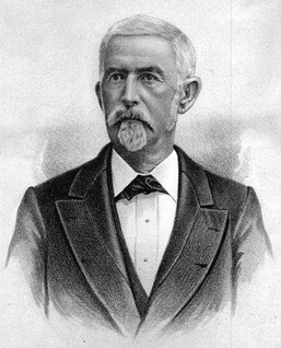
Edward Asbury O'Neal was a Confederate officer during the American Civil War and the 26th Governor of Alabama.

Hugh McVay was the ninth governor of the U.S. state of Alabama from July 17 to November 30, 1837. He was born in South Carolina.
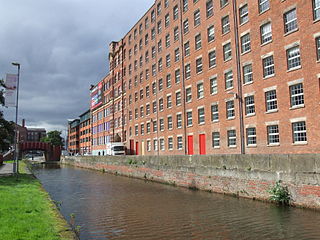
A cotton mill is a building that houses spinning or weaving machinery for the production of yarn or cloth from cotton, an important product during the Industrial Revolution in the development of the factory system.

Little Dixie is a historic 13- to 17-county region along the Missouri River in central Missouri, United States. Its early Anglo-American settlers were largely migrants from the hemp and tobacco districts of Virginia, Kentucky, and Tennessee. They brought enslaved African Americans with them or purchased them as workers in the region. Because Southerners settled there first, the pre-Civil War culture of the region was similar to that of the Upper South. The area was also known as Boonslick country.

Cotton-spinning machinery is machines which process prepared cotton roving into workable yarn or thread. Such machinery can be dated back centuries. During the 18th and 19th centuries, as part of the Industrial Revolution cotton-spinning machinery was developed to bring mass production to the cotton industry. Cotton spinning machinery was installed in large factories, commonly known as cotton mills.

Mississippi Mills was a cotton and wool textile manufacturing complex that operated in Wesson, Mississippi, during the latter half of the 19th century. By 1892, Mississippi Mills was described as the largest industry of its kind in the South.

The Fall River Manufactory was the first cotton mill to be constructed across the Quequechan River in Fall River, Massachusetts, United States. It was also the first successful textile mill in the area.

A doffer is someone who removes "doffs" holding spun fiber such as cotton or wool from a spinning frame and replaces them with empty ones. Historically, spinners, doffers, and sweepers each had separate tasks that were required in the manufacture of spun textiles. From the early days of the industrial revolution, this work, which requires speed and dexterity rather than strength, was often done by children. After World War I, the practice of employing children declined, ending in the United States in 1933. In modern textile mills, doffing machines have now replaced humans.
Village Number 1, also known as The Village and Nitrate Plant Number 1 Reservation Subdivision, is an unincorporated community in Colbert County, Alabama, in the United States.
Center Star, also known as Centre Star, or Centre, is an unincorporated community in Lauderdale County, in the U.S. state of Alabama.
Rhodesville, also known as Rhodes Mill, is an unincorporated community in Lauderdale County, in the U.S. state of Alabama.
Smithsonia, also known as Cave Springs, is an unincorporated community in Lauderdale County, in the U.S. state of Alabama.
Wright, also known as Wrights Cross Roads, is an unincorporated community in Lauderdale County, in the U.S. state of Alabama.
Mars Hill is a former unincorporated community that is now a neighborhood of the city of Florence in Lauderdale County, Alabama, United States.

The Daniel Pratt Cotton Gin Manufactory was a cotton gin factory created by Daniel Pratt in 1854, in what is now Prattville, Alabama, a town named for him. The factory became the largest cotton gin machinery factory in the world and supplied cotton gins to all cotton producing countries.


