Moygownagh

Last updated

Moygownagh
Maigh Ghamhnach
Civil parish
Moygownagh Village Sign.jpg
Sign in Moygownagh
Ireland adm location map.svg
Red pog.svg
Moygownagh
Location in Ireland
Coordinates: 54°09′40″N9°20′45″W / 54.16111°N 9.34583°W / 54.16111; -9.34583
Country Ireland
Province Connacht
County County Mayo
Irish Grid Reference G121244

Moygownagh or Moygawnagh (Irish : Maigh Ghamhnach, meaning 'plain of the cows or calves') is a civil parish and village in the historical barony of Tyrawley, County Mayo, Ireland. [1] Moygownagh borders the parishes of Kilfian, and Crossmolina.

Contents

The parish is on the R315 Crossmolina to Ballycastle road. The local community centre acts as a meeting place and sporting venue in the area.

History

The story of how the parish got its name is told in the 7th century Life of St. Cormac, taken from McFirbis. It relates how St. Cormac while on a journey, came to the place called Moygownagh, where he met St. Daria who was abbess of a nunnery there. She received him so hospitably that on his departure he blessed her and her place of habitation, and prayed that Moygownagh would abound in cows and herds. His prayers were answered, and from then on the place was known as Mag Gamhnach, which means 'plain of the cows with calves'.[ citation needed ]

Although there is no monument in the parish erected in to St. Daria, St. Cormac gives his name to the church. It is thought that St. Daire's convent was situated where the old cemetery now stands.[ citation needed ]

In ancient times, Moygownagh, most of Kilfian and a small part of Crossmolina formed the territory known as Bredach.[ citation needed ]

There was a Protestant church near Garranard Post Office which itself was the parson's residence. The stones remaining in the old Protestant church were used in the foundation of the present parochial house.[ citation needed ] The present church was built in 1846 by Father James McNamera. It is situated in Ardvarney townland, once owned by a landlord called Stackpole.[ citation needed ]

In Samuel Lewis's Topographical Dictionary of Ireland, published in 1837, the area is described as:

MAGANAUGH, or MOYGOWNAGH, a parish, in the barony of Tyrawley, county of Mayo, and province of Connaught, 7 miles (S.W.) from Killala, on the road from Crossmolina to Ballycastle; containing 1,981 inhabitants. This parish is situated on the river Awenmore, and comprises 4100 statute acres; the land is light, chiefly under tillage, with some pasture, and great quantities of bog and mountain; limestone abounds.

The principal seats are Belleville, the residence of Capt. W. Orme; Glenmore, of W. Orme, Esq.; and Stonehall, of T. Knox, Esq. It is a vicarage, in the diocese of Killala, forming part of the union of Crossmolina; the rectory is partly appropriate to the precentorship of Killala, and partly to the vicars choral of Christchurch, Dublin. The tithes amount to £110, of which £35.10 is payable to the vicars choral, £19.10 to the precentor, and £55 to the vicar. The R.C. parish is co-extensive with that of the Established Church; the chapel is small and in bad repair. About 70 children are educated in a public and about 10 in a private school.

Church

Samuel Lewis, writing in the 1830s, spoke of the "R.C. Chapel in Magaunagh" as being "small and in bad repair". This church stood on the road-side about halfway between the present church gate and Mitchells shop. A holy water stoup belonging to this church was preserved beside it for many years.

The present church was built in 1846 and it is situated in Ardvarney townland. The Griffith Valuation (1856) records that the "R.C. chapel and yard" were leased from Andrew Brown, being 5 roods in area and having a valuation of £15-15-0, but exempt from taxes or rates.

Carn National School Pic of Carn N.S. Moygownagh.jpg
Carn National School

There was a stone placed over the entrance of the church which bore the following inscription: "This is the house of God and Gate of Heaven. Erected to the greater glory of God, A.D. 1846". After a porch was erected about 1937, this stone became hidden from view. It was removed in 1973 and inserted in the wall near the priest's graves. Extensive reconstruction and alteration works were carried out at this time also by Fr. Michael Gilroy. The reason for the porch being erected in 1937 was that the door faced the prevailing wind and around that time a severe storm blew in the door and damaged the roof.

There is a relatively new graveyard behind Moygownagh church. [2] The old Moygownagh cemetery is about half a mile south-west of Moygownagh town. The short driveway to the cemetery is on the west side of the Crossmolina road behind iron gates.[ citation needed ]

Glenmore House

Glenmore House in the parish of Moygownagh was known locally as the 'Big House' or the Landlords house. It was built in 1790 with the stones quarried from the nearby wood,. It was owned at the time by William Knox Orme. In 1853, the house and lands were purchased by Fetherstonehaugh. He remained as Landlord until 1930.

During this time, the Land Commission allotted most of the lands to the tenants. Major Aldridge bought the house and remaining lands in 1930. In 1931, the land in Attyshane was divided among the local people but there was still about 215 acres (0.87 km2), including woodlands in the estate.

When Major Aldridge sold the estate, he moved to Mount Falcon, near Ballina. He had a great interest in local history and he collected information and stories for the Folklore Commission.

After Major Aldridge came Mr. Brennan, Mr Hegarty, Captain Hunt, Mr. Latta, Sir John Riss and Mr Somers. Mr Somers sold the estate to Dr. Loftus in 1978. He owned it during his term as President of the G.A.A. Dr. Loftus sold the house and lands to a Mr. Begot in 1989.[ citation needed ]

There was a holy well situated in the vicinity of the Big House. Many people came to pray at the well. Folklore has it that the landlord was displeased with the practice and the steward ordered the workers to fill the well with clay. They refused to obey his order so he took the spade himself and threw in a spadeful of soil. The men then completed the job. The steward became insane shortly afterward.[ citation needed ]

Related Research Articles

<span class="mw-page-title-main">County Mayo</span> County in Ireland

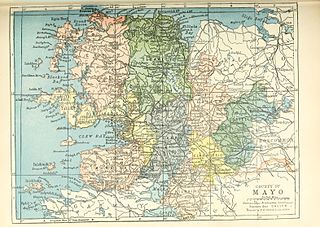
County Mayo is a county in Ireland. In the West of Ireland, in the province of Connacht, it is named after the village of Mayo, now generally known as Mayo Abbey. Mayo County Council is the local authority. The population was 137,231 at the 2022 census. The boundaries of the county, which was formed in 1585, reflect the Mac William Íochtar lordship at that time.

<span class="mw-page-title-main">Killala</span> Village in County Mayo, Ireland

Killala is a village in County Mayo in Ireland, north of Ballina. The railway line from Dublin to Ballina once extended to Killala. To the west of Killala is the townland of Townsplots West, which contains a number of ancient forts. Historically associated with Saint Patrick, and the seat of an episcopal see for several centuries, evidence of Killala's ecclesiastical past include a 12th-century round tower and the 17th century Cathedral Church of St Patrick. As of the 2016 census of Ireland, the village had a population of 562.

<span class="mw-page-title-main">Abbeyfeale</span> Town in County Limerick, Ireland

Abbeyfeale is a historic market town in County Limerick, Ireland, near the border with County Kerry. The town is on the N21 road from Limerick to Tralee, some 21 kilometres south-west of Newcastle West and 16 kilometres south-east of Listowel and 38 kilometres north-east of Tralee. The town is in a civil parish of the same name.

<span class="mw-page-title-main">Headcorn</span> Human settlement in England

Headcorn is a village and civil parish in the borough of Maidstone in Kent, England. The parish is on the floodplain of the River Beult south east of Maidstone.

<span class="mw-page-title-main">Crossmolina</span> Town in County Mayo, Ireland

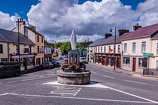
Crossmolina is a town in the historical barony of Tyrawley in County Mayo, Ireland, as well as the name of the parish in which Crossmolina is situated. The town sits on the River Deel near the northern shore of Lough Conn. Crossmolina is about 9 km (5.6 mi) west of Ballina on the N59 road. Surrounding the town, there are a number of agriculturally important townlands, including Enaghbeg, Rathmore, and Tooreen.

Moyvane, also sometimes known as Newtownsandes, is a small village in County Kerry in the south west of Ireland. It is situated off the N69 road between Listowel to the southwest and Tarbert to the north. The village of Knockanure lies to the immediate south. The parish in which the village is located is now also known as the "Parish of Moyvane". It was originally called the parish of Murhur, which was part of the historic barony of Iraghticonnor.

<span class="mw-page-title-main">Murroe</span> Village in County Limerick, Ireland

Murroe, officially spelled Moroe, is a village in County Limerick, Ireland.

<span class="mw-page-title-main">Borrisoleigh</span> Small town in County Tipperary, Ireland

Borrisoleigh is a small town in County Tipperary, Ireland. At the 2016 census, it had a population of 679. It is in the ecclesiastical parish of Borrisoleigh and Ileigh in the Roman Catholic Archdiocese of Cashel and Emly.

<span class="mw-page-title-main">Upton Bishop</span> Human settlement in England

Upton Bishop is a small village in Herefordshire, England. The population of the village at the 2011 census was 602.

<span class="mw-page-title-main">Moydow</span> Village near Longford town, Ireland

Moydow is a village on the outskirts of Longford town in County Longford, Ireland.

<span class="mw-page-title-main">Roman Catholic Diocese of Killala</span> Catholic diocese in Ireland

The Diocese of Killala is a Latin Church diocese of the Catholic Church in Connacht; the western province of Ireland. It is in the Metropolitan Province of Tuam and is subject to the Metropolitan Archdiocese of Tuam. As of 2023, the bishop is John Fleming, who was appointed on 7 April 2002.

<span class="mw-page-title-main">Kilmovee</span> Village in Connacht, Ireland

Kilmovee is a village and civil parish in County Mayo, Ireland. It is a mainly rural parish on the R325 road, midway between Kilkelly and Ballaghaderreen.

<span class="mw-page-title-main">Adamstown, County Wexford</span> Village in County Wexford, Ireland

Adamstown is a village in County Wexford, Ireland. It is about 24 km (15 mi) north-west of Wexford, 20 km (12 mi) east of New Ross, and 20 km (12 mi) south-west of Enniscorthy.

<span class="mw-page-title-main">Mahoonagh</span> Village in County Limerick, Ireland

Mahoonagh or Castlemahon is a village and civil parish in County Limerick, Ireland. The village lies four kilometres south east of the town of Newcastle West.

The Conmhaícne Mheáin Maigh or Conmaicne Mhein or Conmaicne Máenmaige or Conmaicne Críche Meic Erca were an early people of Ireland, their tuath comprising the barony of Loughrea, in County Galway.

<span class="mw-page-title-main">Tirawley</span> Barony of County Mayo

Tirawley, archaically known as Tyrawley, is a barony extending southward from the north coast of County Mayo, Ireland. It was created during the shiring of County Mayo out of the Gaelic túath or territory of Tír Amhlaidh, from which it takes its name.

Fr. Brendan Hoban is an Irish Catholic priest in the Killala Diocese, columnist and author of a number of books. Fr. Hoban was born in Ballycastle, Co. Mayo in 1948. Educated in Ballycastle Boys National School, St Muredach¹s College, Ballina and entered St Patrick's College, Maynooth in 1966 and was ordained for the diocese of Killala in 1973. He writes a weekly column in the Western People.

<span class="mw-page-title-main">Ballina, County Mayo</span> Town in County Mayo, Ireland

Ballina is a town in north County Mayo, Ireland. It lies at the mouth of the River Moy near Killala Bay, in the Moy valley and Parish of Kilmoremoy, with the Ox Mountains to the east and the Nephin Beg mountains to the west. The town occupies two baronies; Tirawley on the west bank of the Moy River, and Tireragh, a barony within County Sligo, on its east banks. At the 2022 census, the population of Ballina was 10,556.

<span class="mw-page-title-main">Gub (Glangevlin)</span> Townland in County Cavan, Ireland

Gub, an Anglicisation of the Gaelic, 'Gob', meaning The Headland, is a townland in the civil parish of Templeport, County Cavan, Ireland. It lies in the Roman Catholic parish of Glangevlin and barony of Tullyhaw. It is also known as Garvalt Upper. It contains part of the village of Glangevlin.

Enaghbeg is a townland located in the Barony of Tirawley, in the County of Mayo. It is in the Electoral Division of Deel, in a civil parish of Crossmolina. Agriculture is the primary economic activity.

References

  1. "Maigh Ghamhnach / Moygawnagh". logainm.ie. Placenames Database of Ireland. Retrieved 3 March 2023.
  2. "Moygawnagh New Graveyard Headstones". goldenlangan.com. Retrieved 3 March 2023.