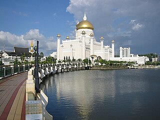
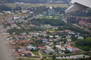
Brunei-Muara District or simply Brunei-Muara is one of the four districts of Brunei. It has the smallest area among the four districts, with 571 square kilometres (220 sq mi), yet is the most populous, with 289,630 people as of 2016. Bandar Seri Begawan, the country's capital, is located in this district, which is also de facto the district's capital. It is also home to Brunei International Airport, the country's only international airport, as well as Muara Port, the main and only deep-water port in the country. The Brunei River flows within this district and is home to Kampong Ayer, the traditional historic settlement on stilts above the river.

Kampung Ayer is a prominent traditional settlement in Bandar Seri Begawan, the capital of Brunei. It comprises neighbourhoods of traditional houses, schools and mosques built on stilts above the Brunei River near the capital's city centre. It has an area of about 10 square kilometres (3.9 sq mi); the total population was 10,250 in 2016. It has been historically nicknamed 'Venice of the East'. Kampung Ayer has been historically the principal settlement of Brunei; it was the de facto capital, in particular social and economic centre, of the Bruneian Empire for a few centuries, but also extending into the early period during British imperialism in Brunei.

Mukim Kuala Belait is a mukim in Belait District, Brunei. The population was 31,308 in 2016. The mukim encompasses Kuala Belait, the administrative town of the district.
Mukim Bukit Sawat is a mukim in Belait District, Brunei. It had a population of 794 in 2016.

Mukim Berakas 'A' is a mukim in Brunei-Muara District, Brunei. The population was 27,223 in 2016.

Mukim Berakas 'B' is a mukim in Brunei-Muara District, Brunei. The population was 40,710 in 2016.

Mukim Peramu is a mukim in Brunei-Muara District, Brunei. It is located within Kampong Ayer, the historical stilt settlements on the Brunei River in the capital Bandar Seri Begawan. The population was 1,111 in 2016.

Mukim Saba is a mukim in Brunei-Muara District, Brunei. It is part of Kampong Ayer, the traditional stilted settlements on the Brunei River in the capital Bandar Seri Begawan. The population was 1,000 in 2016. It encompasses the village of Kampong Saba.

Mukim Sungai Kebun is a mukim in Brunei-Muara District, Brunei. It is part of Kampong Ayer, the traditional stilt settlements on the Brunei River in the capital Bandar Seri Begawan. The population was 4,750 in 2016.

Mukim Sungai Kedayan was a mukim in Brunei-Muara District, Brunei. It was located within Kampong Ayer, the historical stilt settlements on the Brunei River in the capital Bandar Seri Begawan. The population was 230 in 2016.

Mukim Amo is a mukim in Temburong District, Brunei. It has an area of 542 square kilometres (209 sq mi); the population was 2,144 in 2016.

Kampong Keriam is a village in Tutong District, Brunei, about 6 kilometres (3.7 mi) from the district town Pekan Tutong. The population was 2,195 in 2016. It is one of the villages within Mukim Keriam, a mukim in the district.

Kampong Burong Pingai Ayer is a village in Brunei-Muara District, Brunei, within Mukim Burong Pingai Ayer. It is located within Kampong Ayer, the traditional stilted settlements on the Brunei River in the country's capital Bandar Seri Begawan. The population was 514 in 2016.

Kampong Sengkarai is a village in Tutong District, Brunei, on the outskirts of the district town Pekan Tutong. The population was 1,989 in 2016. It is one of the villages within Mukim Pekan Tutong.

Kampong Jaya Setia is a village in Brunei-Muara District, Brunei, and a neighbourhood in the capital Bandar Seri Begawan. The population was 855 in 2016. It is one of the villages within Mukim Berakas 'A'. The postcode is BB2713.
Kampong Burong Pingai Berakas is a village in Brunei-Muara District, Brunei, and a neighbourhood in the capital Bandar Seri Begawan. The population was 564 in 2016. It is one of the villages within Mukim Berakas 'A'. The postcode is BB3313.

Kampong Pengiran Siraja Muda Delima Satu is a village in Brunei-Muara District, Brunei, and a neighbourhood in the capital Bandar Seri Begawan. The population was 2,354 in 2016. It is one of the villages within Mukim Berakas 'A'. The postcode is BB5113.
Kampong Long Mayan, sometimes written as Kampong Long Mayan, is a village in the interior of Tutong District, Brunei, about 40 kilometres (25 mi) from the district town Pekan Tutong. The population was 265 in 2016. It is one of the villages within Mukim Ukong, a mukim subdivision in the district.

Kampong Penabai is a coastal village in Tutong District, Brunei, about 4–5 kilometres (2.5–3.1 mi) from the district town Pekan Tutong. The population was 888 in 2016. It is one of the villages within Mukim Pekan Tutong, a mukim in the district.

