
Tutong District or simply Tutong is one of the four districts of Brunei. It has an area of 1,166 square kilometres (450 sq mi); the population was 48,313 in 2016. The administrative town is Pekan Tutong. It is home to Tasek Merimbun, the country's largest natural lake.

Mukim Labi is a mukim in the interior of Belait District, Brunei. It has an area of 361.8 square kilometres (139.7 sq mi); the population was 1,216 in 2016.

Mukim Bukit Sawat is a mukim in Belait District, Brunei. It had a population of 794 in 2016.

Mukim Lamunin is a mukim in Tutong District, Brunei. The population was 4,298 in 2016.

Mukim Sukang is a mukim in Belait District, Brunei. The population was 169 in 2016.

Mukim Amo is a mukim in Temburong District, Brunei. It has an area of 542 square kilometres (209 sq mi); the population was 1,657 in 2021.

Kampong Penanjong is a village in Tutong District, Brunei, on the outskirts of the district town Pekan Tutong. The population was 1,856 in 2021. It is one of the villages within Mukim Pekan Tutong, a mukim in the district.

Kampong Keriam is a village in Tutong District, Brunei, about 6 kilometres (3.7 mi) from the district town Pekan Tutong. The population was 2,195 in 2016. It is one of the villages within Mukim Keriam, a mukim in the district.

Kampong Serasa is a village in Brunei-Muara District, Brunei, near the port town Muara. The population was 3,200 in 2016. It is home to Serasa Ferry Terminal, the country's primary international ferry terminal.
Kampong Sinaut is a village in Tutong District, Brunei, about 12 kilometres (7.5 mi) from the district town Pekan Tutong. The population was 932 in 2016. It is one of the villages within Mukim Keriam.

Kampong Bukit Beruang, also simply known as Bukit Beruang, is a village in Tutong District, Brunei, about 13 kilometres (8.1 mi) from the district town Pekan Tutong. The population was 6,157 in 2016. It is one of the villages within Mukim Telisai, a mukim subdivision in the district. It comprises the original village settlement as well as the public housing estate Bukit Beruang National Housing Scheme.

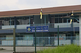
Kampong Telisai, also simply known as Telisai, is a coastal village in Tutong District, Brunei, about 17 kilometres (11 mi) from the district town Pekan Tutong. The village also encompasses the public housing area STKRJ Kampong Telisai. The population was 2,293 in 2016. It is one of the villages within Mukim Telisai. The postcode is TC1145.

Kampong Sengkarai is a village in Tutong District, Brunei, on the outskirts of the district town Pekan Tutong. The population was 1,694 in 2021. It is one of the villages within Mukim Pekan Tutong.

Kampong Bukit Udal or simply known as Bukit Udal, is a village in Tutong District, Brunei, about 11 kilometres (6.8 mi) from the district town Pekan Tutong. It has an area of 13 square kilometres ; the population was 1,306 in 2016. It is one of the villages within Mukim Tanjong Maya, a mukim in the district.

Kampong Lubok Pulau is a village in Tutong District, Brunei, about 7 kilometres (4.3 mi) from the district town Pekan Tutong. The population was 496 in 2016. It is one of the villages within Mukim Tanjong Maya, a mukim in the district.
Kampong Penapar is a village in Tutong District, Brunei, about 11–12 kilometres (6.8–7.5 mi) from the district town Pekan Tutong. The population was 443 in 2016. It is one of the villages within Mukim Tanjong Maya, a mukim in the district.
Kampong Tanjong Maya is a village in Tutong District, Brunei, about 8 kilometres (5.0 mi) from the district town Pekan Tutong. The population was 488 in 2016. It is one of the villages within Mukim Tanjong Maya, a mukim in the district.
Kampong Birau is a village in the north-east of Tutong District, Brunei, about 19 kilometres (12 mi) from the district town Pekan Tutong. It has an area of 13.5 square miles (35 km2); the population was 989 in 2016. It is one of the villages within Mukim Kiudang, a mukim in the district.

Kampong Penabai is a coastal village in Tutong District, Brunei, about 4–5 kilometres (2.5–3.1 mi) from the district town Pekan Tutong. The population was 749 in 2021. It is one of the villages within Mukim Pekan Tutong, a mukim in the district.

