Mullins, South Carolina

Last updated

Mullins, South Carolina
MullinsSC.jpg
Downtown Mullins
Mullins, SC City seal.jpg
Nickname: 
"The City of Opportunity"
USA South Carolina location map.svg
Red pog.svg
Mullins, South Carolina
Location of Mullins in South Carolina
Coordinates: 34°12′19″N79°15′29″W / 34.20528°N 79.25806°W / 34.20528; -79.25806
Country United States
State South Carolina
County Marion
Government
   Mayor Robert Woodbury
Area
[1]
  Total3.02 sq mi (7.82 km2)
  Land3.02 sq mi (7.82 km2)
  Water0.00 sq mi (0.00 km2)
Elevation
98 ft (30 m)
Population
 (2020) [2]
  Total4,026
  Density1,332.67/sq mi (514.52/km2)
Time zone UTC-5 (EST)
  Summer (DST) UTC-4 (EDT)
ZIP code
29574
Area code(s) 843, 854
FIPS code 45-48805 [3]
GNIS feature ID1224890 [4]
Website www.mullinssc.us

Mullins is a city in Marion County, South Carolina, United States. As of the 2010 census, the city population was 4,663.

Contents

Incorporated on March 4, 1872, Mullins was named after Col. William S. Mullins, who served as a representative for Marion County in the South Carolina State Legislature from 1852 to 1866.

History

On March 4, 1872, the charter was approved for the town of Mullins. The same year the Macedonia Methodist church was established, the first church within city limits. By 1878, the city of Mullins had a population of 75 people, a total of 12 families. There were only three stores and four unpaved streets: Railroad, Main, Smith, and Gapway Streets. Gapway Road was designed from 76 Hwy in 1933.

In 1894, the growth and sale of tobacco sparked the further development of the city of Mullins. At one time, the town was the largest tobacco producing/marketing industry in the United States. Mullins became the largest distributor of tobacco in the country, known as "South Carolina's Largest, The world's best tobacco market." In the late 1920s the tobacco festival was started and is still celebrated today. The tobacco festival is known as the 'Golden Leaf Festival."

Mullins' first school was established in 1872, which was attended by boys and girls from the town, nearby rural areas, and neighboring counties. The first schoolhouse was built in 1904; a brick, two-story building on Academy Street. A second schoolhouse was built in 1913, on the corner of Main and Academy streets. Mullins High School was built in 1923 on North Park Street where it stood until burning in 1976. It was rebuilt close to the old Marion highway, outside of the city limits. McCormick Elementary School was built on Sandy Bluff Road in 1956. The original Palmetto School for Negroes (High and Elementary) was built on Cypress Street in 1919 and around 1956 was split up. The Palmetto Elementary School was built on Broad Street. The Palmetto High School was built on O'Neal Street with 1970 being the last graduating class. It became Palmetto Middle School as it remains today. In 1970 all schools were combined into a fully integrated school system.

In 1910, the public library was established. The current library, located at the corner of N. Main and Wine Streets, was built in 1940.

The A.H. Buchan Company Building, Dillard Barn, Imperial Tobacco Company Building, Liberty Warehouse, Mt. Olive Baptist Church, Mullins Commercial Historic District, Neal and Dixon's Warehouse, Old Brick Warehouse, Rasor and Clardy Company Building, and J.C. Teasley House are listed on the National Register of Historic Places. [5]

Geography

Mullins is located at 34°12′19″N79°15′19″W / 34.20528°N 79.25528°W / 34.20528; -79.25528 (34.205239, -79.255309). [6]

According to the United States Census Bureau, the city has a total area of 3.0 square miles (7.8 km2), all land.

Demographics

Historical population
CensusPop.Note
1890 242
1900 828242.1%
1910 1,832121.3%
1920 2,37929.9%
1930 3,15832.7%
1940 4,39239.1%
1950 4,91611.9%
1960 6,22926.7%
1970 6,006−3.6%
1980 6,0681.0%
1990 5,910−2.6%
2000 5,029−14.9%
2010 4,663−7.3%
2020 4,026−13.7%
U.S. Decennial Census [7] [2]

2020 Census

Mullins racial composition [8]
RaceNum.Perc.
White (non-Hispanic)1,07226.63%
Black or African American (non-Hispanic)2,73868.01%
Native American 180.45%
Asian 250.62%
Other/Mixed 1072.66%
Hispanic or Latino 661.64%

As of the 2020 United States census, there were 4,026 people, 1,535 households, and 930 families residing in the city.

2000 Census

As of the census [3] of 2000, there were 5,029 people, 2,001 households, and 1,324 families residing in the city. The population density was 1,647.8 inhabitants per square mile (636.2/km2). There were 2,312 housing units at an average density of 757.6 per square mile (292.5/km2). The racial makeup of the city was 61.58% African American, 36.59% White, 0.28% Native American, 0.68% Asian, 0.12% from other races, and 0.76% from two or more races. Hispanic or Latino of any race were 0.93% of the population.

There were 2,001 households, out of which 29.3% had children under the age of 18 living with them, 33.1% were married living together, 29.1% had a female householder with no husband present, and 33.8% were non-families. 31.1% of all households were made up of individuals, and 14.5% had someone living alone who was 65 years of age or older. The average household size was 2.46 and the average family size was 3.08.

In the city, the population was spread out, with 27.6% under the age of 18, 8.8% from 18 to 24, 23.5% from 25 to 44, 23.2% from 45 to 64, and 16.9% who were 65 years of age or older. The median age was 38 years. For every 100 females, there were 73.2 males. For every 100 females age 18 and over, there were 65.5 males.

The median income for a household in the city was $20,154, and the median income for a family was $25,218. Males had a median income of $26,233 versus $16,572 for females. The per capita income for the city was $12,183. About 25.3% of families and 28.7% of the population were below the poverty line, including 44.2% of those under age 18 and 20.0% of those age 65 or over.

Government

The city is run by an elected council-mayor government system.

The first Mullins Fire Department was established in the early 1920s. The first fire wagon was a regular farm wagon with a ladder and 20 to 30 buckets hanging from the sides. The wagon was pulled by manpower and the equipment was operated by the first men who arrived to help.

Education

Mullins has a public library, a branch of the Marion County Library System. [9]

Notable people

Related Research Articles

<span class="mw-page-title-main">Marion County, South Carolina</span> County in South Carolina, United States

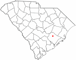
Marion County is a county located in the coastal plain of the U.S. state of South Carolina. As of the 2020 census, its population was 29,183. Its county seat is Marion. It is a majority-minority county.

<span class="mw-page-title-main">Calhoun County, South Carolina</span> County in South Carolina, United States

Calhoun County is a county in the U.S. state of South Carolina. As of the 2020 census, its population was 14,119, making it the third-least populous county in the state. Its county seat is St. Matthews. In terms of land area, it is also the smallest county in the state.

<span class="mw-page-title-main">Berkeley County, South Carolina</span> County in South Carolina, United States

Berkeley County is a county in the U.S. state of South Carolina. As of the 2020 census, its population was 229,861. Its county seat is Moncks Corner, and the largest community is Goose Creek. After two previous incarnations of Berkeley County, the current county was created in 1882. Berkeley County is included in the Charleston-North Charleston, SC Metropolitan Statistical Area.

<span class="mw-page-title-main">Allendale County, South Carolina</span> County in South Carolina, United States

Allendale County is a county located in the U.S. state of South Carolina. As of the 2020 census, the population was 8,039, making it the least populous county in South Carolina. Its county seat is Allendale.

<span class="mw-page-title-main">Union City, Georgia</span> City in Georgia, United States

Union City is a city in Fulton County, Georgia, United States. The population was 26,830 at the 2020 census.

<span class="mw-page-title-main">Mayodan, North Carolina</span> Town in North Carolina, United States

Mayodan is a town in Rockingham County, North Carolina, in the United States. It is a manufacturing site for Sturm, Ruger & Co., Bridgestone Aircraft Tire, and formerly General Tobacco. Washington Mills Company, later Tultex, operated a textile mill in Mayodan until 1999.

<span class="mw-page-title-main">Stoneville, North Carolina</span> Town in North Carolina, United States

Stoneville is a town in Rockingham County, North Carolina, United States. Stoneville is part of the Greensboro–High Point metropolitan area of the Piedmont Triad. On March 20, 1998, an F-3 tornado touched down in neighboring Madison and Mayodan after the system had crossed into Rockingham County from Stokes County. Then, it strengthened into an F-3 as it crossed Route 220 as it followed the train tracks to downtown Stoneville.

<span class="mw-page-title-main">Belton, South Carolina</span> City in South Carolina, United States

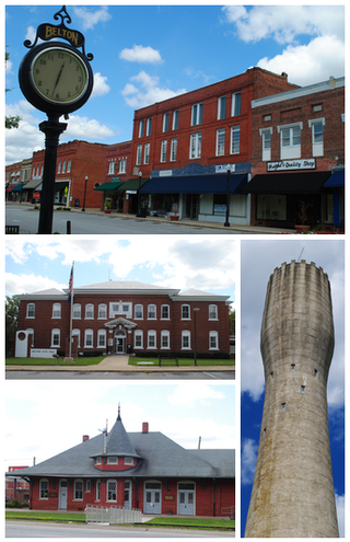
Belton is a city in eastern Anderson County, South Carolina. The population was 4,134 at the 2010 census.

<span class="mw-page-title-main">Williamston, South Carolina</span> Town in South Carolina, United States

Williamston is a town in Anderson County, South Carolina. The population was 4,043 at the 2020 census.

<span class="mw-page-title-main">Bonneau, South Carolina</span> Town in South Carolina, United States

Bonneau is a town in Berkeley County, South Carolina, United States. The population was 487 at the 2010 census. It is part of the Charleston–North Charleston–Summerville Metropolitan Statistical Area.

<span class="mw-page-title-main">Dillon, South Carolina</span> City in South Carolina, United States

Dillon is a city in Dillon County in eastern South Carolina, United States. It is the county seat and largest city of Dillon County. It was established on December 22, 1888. Both the name of the city and county comes from James W. Dillon, an early settler and key figure in bringing a railroad through the area. The population was 6,788 in the 2010 U.S. census.

<span class="mw-page-title-main">Latta, South Carolina</span> Town in South Carolina, United States

Latta is a town in Dillon County, South Carolina, United States. Latta is the second most populous town in Dillon County. As of the 2010 census, it had a population of 1,379.

<span class="mw-page-title-main">Florence, South Carolina</span> City in South Carolina, United States

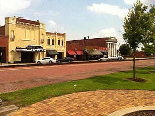
Florence is a city in and the county seat of Florence County, South Carolina, United States. It lies at the intersection of Interstates 20 and 95 and is the eastern terminus of the former. It is the primary city within the Florence metropolitan area. The area forms the core of the historical Pee Dee region of South Carolina, which includes the eight counties of northeastern South Carolina, along with sections of southeastern North Carolina. As of the 2020 census, the population of the city was 39,899, making it the 10th-most populous city in the state.

<span class="mw-page-title-main">Travelers Rest, South Carolina</span> City in South Carolina, United States

Travelers Rest is a city in Greenville County, South Carolina. The population was 7,788 at the 2020 census. It is part of the Greenville-Mauldin-Easley Metropolitan Statistical Area. Travelers Rest, the northernmost city in Greenville County, is located 10 miles north of Greenville and around 20 miles south of the North Carolina border. Furman University, a private liberal-arts university, was annexed into the city limits of Travelers Rest in April 2018 and North Greenville University, a private Christian institution, is located in nearby Tigerville.

<span class="mw-page-title-main">Lancaster, South Carolina</span> City in South Carolina, United States

The city of Lancaster is the county seat of Lancaster County, South Carolina, United States, located in the Charlotte Metropolitan Area. As of the United States Census of 2010, the city population was 8,526. The city was named after the famous House of Lancaster.

<span class="mw-page-title-main">Marion, South Carolina</span> City in South Carolina, United States

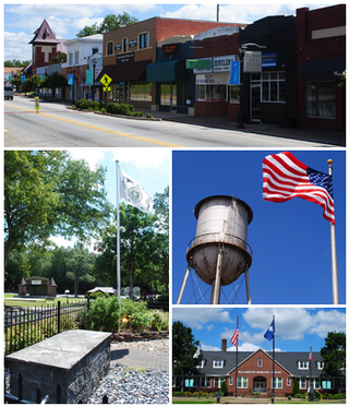
Marion is a city in and the county seat of Marion County, South Carolina, United States. It is named for Francis Marion, a brigadier general from South Carolina in the American Revolutionary War. The population was 6,939 at the 2010 census.

<span class="mw-page-title-main">Nichols, South Carolina</span> Town in South Carolina, United States

Nichols is a town in Marion County, South Carolina, United States. The population was 368 at the 2010 census.

<span class="mw-page-title-main">Seneca, South Carolina</span> City in South Carolina, United States

Seneca is a city in Oconee County, South Carolina, United States. The population was 8,102 at the 2010 census. It is the principal city of the Seneca Micropolitan Statistical Area, an (MSA) that includes all of Oconee County, and that is included within the greater Greenville-Spartanburg-Anderson, South Carolina Combined Statistical Area. Seneca was named for the nearby Cherokee town of Isunigu, which English colonists knew as "Seneca Town".

<span class="mw-page-title-main">Union, South Carolina</span> City in South Carolina, United States

The city of Union is the county seat of Union County, South Carolina, United States. The population was 8,393 at the 2010 census. It is the principal city of the Union Micropolitan Statistical Area, which includes all of Union County and which is further included in the greater Greenville-Spartanburg-Anderson, South Carolina Combined Statistical Area.

<span class="mw-page-title-main">Hemingway, South Carolina</span> Town in South Carolina, United States

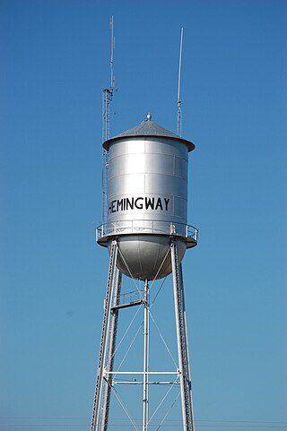
Hemingway is a town in Williamsburg County, South Carolina, United States. The population was 459 at the 2010 census.

References

  1. "ArcGIS REST Services Directory". United States Census Bureau. Retrieved October 15, 2022.
  2. 1 2 "Census Population API". United States Census Bureau. Retrieved October 15, 2022.
  3. 1 2 "U.S. Census website". United States Census Bureau . Retrieved January 31, 2008.
  4. "US Board on Geographic Names". United States Geological Survey. October 25, 2007. Retrieved January 31, 2008.
  5. "National Register Information System". National Register of Historic Places . National Park Service. July 9, 2010.
  6. "US Gazetteer files: 2010, 2000, and 1990". United States Census Bureau. February 12, 2011. Retrieved April 23, 2011.
  7. "Census of Population and Housing". Census.gov. Retrieved June 4, 2015.
  8. "Explore Census Data". data.census.gov. Retrieved December 15, 2021.
  9. "Locations & Hours". Greenville County Library System. Retrieved June 13, 2019.
  10. "Edgar McGowan, former state Labor Department director, dies". Associated Press. February 23, 2004. Retrieved January 25, 2020 via AccessWDUN.
  11. "Joseph O. Rogers, Jr., Papers" (PDF). library.sc.edu. Retrieved May 3, 2014.
  12. Ngangura, Tarisai. "Up and Coming". Vanity Fair. Vanity Fair. Retrieved June 10, 2021.
  13. https://www.charlotteobserver.com/sports/nfl/carolina-panthers/article287590365.html