Nichols, South Carolina

Last updated

Nichols, South Carolina
R.J. Corman Railroad train passing through Nichols.jpg
Train passing through Nichols, 2019
SCMap-doton-Nichols.PNG
Location of Nichols in South Carolina
Coordinates: 34°13′58″N79°8′55″W / 34.23278°N 79.14861°W / 34.23278; -79.14861
Country United States
State South Carolina
County Marion
Area
[1]
  Total1.34 sq mi (3.46 km2)
  Land1.34 sq mi (3.46 km2)
  Water0.00 sq mi (0.00 km2)
Elevation
56 ft (17 m)
Population
 (2020) [2]
  Total234
  Density175.15/sq mi (67.60/km2)
Time zone UTC-5 (EST)
  Summer (DST) UTC-4 (EDT)
ZIP code
29581 [3]
Area code(s) 843 and 854
FIPS code 45-50110 [4]
GNIS feature ID1225046 [5]

Nichols is a town in Marion County, South Carolina, United States. The population was 368 at the 2010 census.

Contents

Geography

Nichols is located at 34°13′58″N79°8′55″W / 34.23278°N 79.14861°W / 34.23278; -79.14861 (34.232779, -79.148513). [6]

According to the United States Census Bureau, the town has a total area of 1.4 square miles (3.6 km2), all land.

History

The town was founded around the same time as Marion and Mullins, which was sometime after 1854 and was initially known as Floydsville. This was due to the land being on Harman Floyd's land that was sold off as town lots after his passing. These lots were surrounding depots for the Wilmington and Manchester Railroad. The town experienced a minor boom due to the turpentine industry, which shortly died out and was replaced by the tobacco industry. Later on, the town was renamed to its current title of Nichols, this time to honor Averett B. Nichols, who was a businessman that built a warehouse and store to take advantage of the tobacco boom and owned other stores in the town beside those of John H. Stroud and C. R. Ford. Following World War II, a popular employer was a local store focusing in furniture that went by the name Pilliod of Carolina. [7] [8]

The town suffered severe flooding from Hurricane Matthew from the nearby Lumber River in 2016. Five months after the hurricane, 216 of the town's 261 homes remained vacant. Two of six churches remained closed, as were 15 of 22 businesses, the library, and most of the fire and police department resources. Mayor Lawson Battle suggested that the State House request that the Senate requisition $700,000 to help repair nearly 400 water-damaged buildings, replace vehicles, and reopen government offices. State Senator Kent Williams proposed this money be taken from the $4.5 million left over from a 2015 farmer aid package for storm damage. [9]

Demographics

Historical population
CensusPop.Note
1880 122
1890 57−53.3%
1900 8243.9%
1910 11843.9%
1920 19161.9%
1930 23925.1%
1940 29222.2%
1950 38030.1%
1960 61762.4%
1970 549−11.0%
1980 60610.4%
1990 528−12.9%
2000 408−22.7%
2010 368−9.8%
2020 234−36.4%
U.S. Decennial Census [10] [2]

As of the census [4] of 2000, there were 408 people, 176 households, and 120 families residing in the town. The population density was 293.8 inhabitants per square mile (113.4/km2). There were 199 housing units at an average density of 143.3 per square mile (55.3/km2). The racial makeup of the town was 51.96% White, 47.06% African American, 0.25% Native American, and 0.74% from two or more races.

There were 176 households, out of which 17.6% had children under the age of 18 living with them, 44.3% were married couples living together, 19.3% had a female householder with no husband present, and 31.8% were non-families. 29.5% of all households were made up of individuals, and 13.6% had someone living alone who was 65 years of age or older. The average household size was 2.32 and the average family size was 2.85.

In the town, the population was spread out, with 18.6% under the age of 18, 12.5% from 18 to 24, 22.3% from 25 to 44, 27.5% from 45 to 64, and 19.1% who were 65 years of age or older. The median age was 43 years. For every 100 females, there were 83.0 males. For every 100 females age 18 and over, there were 76.6 males.

The median income for a household in the town was $41,597, and the median income for a family was $43,393. Males had a median income of $30,000 versus $19,306 for females. The per capita income for the town was $18,092. About 6.6% of families and 11.4% of the population were below the poverty line, including 8.9% of those under age 18 and 4.1% of those age 65 or over.

Education

Nichols has a public library, which is a branch of the Marion County Library System. [11]

Related Research Articles

<span class="mw-page-title-main">Marion County, South Carolina</span> County in South Carolina, United States

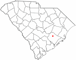
Marion County is a county located in the coastal plain of the U.S. state of South Carolina. As of the 2020 census, its population was 29,183. Its county seat is Marion. It is a majority-minority county.

<span class="mw-page-title-main">Rogersville, Alabama</span> Town in Alabama, United States

Rogersville is a town in Lauderdale County, Alabama, United States. As of the 2018 census, the population of the town is 1,231, up from 1,199 in 2000.

<span class="mw-page-title-main">Menifee, Arkansas</span> Town in Arkansas, United States

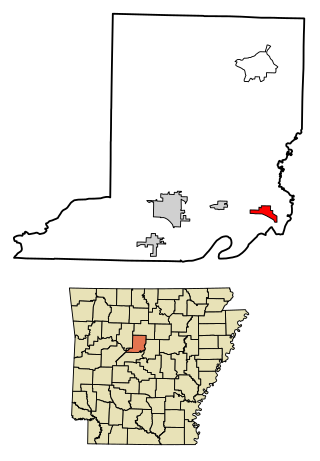
Menifee is a town in Conway County, Arkansas, United States. The population was 302 at the 2010 census.

<span class="mw-page-title-main">Brooksville, Mississippi</span> Town in Mississippi, United States

Brooksville is a town in Noxubee County, Mississippi, United States. The population was 1,223 at the 2010 census.

<span class="mw-page-title-main">Sheep Springs, New Mexico</span> CDP in New Mexico, United States

Sheep Springs is a census-designated place (CDP) in San Juan County, New Mexico, United States. The population was 237 at the 2000 census. It is part of the Farmington Metropolitan Statistical Area.

<span class="mw-page-title-main">Bayboro, North Carolina</span> Town in North Carolina, United States

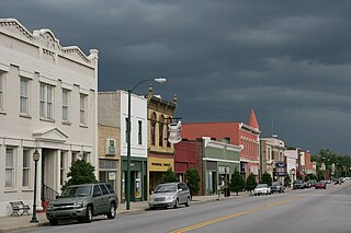
Bayboro is a town in Pamlico County, North Carolina, United States. The population was 1,161 at the 2020 U.S. census. It is the county seat of Pamlico County.

<span class="mw-page-title-main">Seven Springs, North Carolina</span> Town in North Carolina, United States

Seven Springs is a town in Wayne County, North Carolina, United States. It lies next to the Neuse River. The 2012 population was estimated at 111. It is included in the Goldsboro, North Carolina Metropolitan Statistical Area.

<span class="mw-page-title-main">Point Marion, Pennsylvania</span> Borough in Pennsylvania, United States

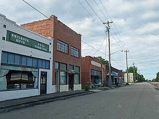
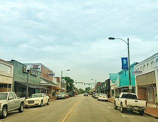
Point Marion is a borough in Fayette County, Pennsylvania, United States. The population was 1,152 at the 2020 census, a decline from the figure of 1,159 tabulated in 2010. It is served by the Albert Gallatin Area School District.

<span class="mw-page-title-main">Perry, South Carolina</span> Town in South Carolina, United States of America

Perry is a town in Aiken County, South Carolina, United States. The population was 233 at the 2010 census. It is part of the Augusta, Georgia metropolitan area.

<span class="mw-page-title-main">Bonneau, South Carolina</span> Town in South Carolina, United States

Bonneau is a town in Berkeley County, South Carolina, United States. The population was 487 at the 2010 census. It is part of the Charleston–North Charleston–Summerville Metropolitan Statistical Area.

<span class="mw-page-title-main">St. Stephen, South Carolina</span> Town in South Carolina, United States

St. Stephen is a town in Berkeley County, South Carolina, United States. The population was 1,697 at the 2010 census.

<span class="mw-page-title-main">McClellanville, South Carolina</span> Town in South Carolina, United States

McClellanville is a small fishing town in rural Charleston County, South Carolina, United States. The population was 605 at the 2020 census. It is situated on the Atlantic coast, on land surrounded by Francis Marion National Forest, and has traditionally derived its livelihood from the Atlantic Ocean and coastal marshes by fishing, shrimping and oystering. McClellanville is part of the Charleston-North Charleston-Summerville metropolitan area and the Charleston-North Charleston Urbanized Area.

<span class="mw-page-title-main">Lake View, South Carolina</span> Town in South Carolina, United States

Lake View is a town in Dillon County, South Carolina, United States. The population was 807 at the 2010 census.

<span class="mw-page-title-main">Garden City, South Carolina</span> CDP in South Carolina, United States

Garden City, sometimes known as Garden City Beach, is a census-designated place (CDP) in Horry County, South Carolina, United States. The population was 9,209 at the 2010 census. Garden City Beach is located directly south of Surfside Beach. The developed part of the beach extends south beyond the limits of the Garden City CDP, into Georgetown County, and ends on a peninsula at the mouth of Murrells Inlet.

<span class="mw-page-title-main">Marion, South Carolina</span> City in South Carolina, United States

Marion is a city in and the county seat of Marion County, South Carolina, United States. It is named for Francis Marion, a brigadier general from South Carolina in the American Revolutionary War. The population was 6,939 at the 2010 census.

<span class="mw-page-title-main">Mullins, South Carolina</span> City in South Carolina, United States

Mullins is a city in Marion County, South Carolina, United States. As of the 2010 census, the city population was 4,663.

<span class="mw-page-title-main">Sellers, South Carolina</span> Town in South Carolina, United States

Sellers is a small town in Marion County, South Carolina, United States. The population was 219 at the 2000 census.

<span class="mw-page-title-main">Blenheim, South Carolina</span> Town in South Carolina, United States

Blenheim is a town in Marlboro County, South Carolina, United States. The population was 154 at the 2010 census. It is named for Blenheim Palace in Oxfordshire, England. Blenheim Palace was the residence of the Duke of Marlborough, after whom Marlboro County is named.

<span class="mw-page-title-main">Arcadia Lakes, South Carolina</span> Town in South Carolina, United States

Arcadia Lakes is a town in Richland County, South Carolina, United States. The population was 861 at the 2010 census. It is part of the Columbia, South Carolina, Metropolitan Statistical Area.

<span class="mw-page-title-main">Scandinavia, Wisconsin</span> Village in Wisconsin, United States

Scandinavia is a village in the Town of Scandinavia in Waupaca County, Wisconsin, United States. The population was 328 at the 2010 census.

References

  1. "ArcGIS REST Services Directory". United States Census Bureau. Retrieved October 15, 2022.
  2. 1 2 "Census Population API". United States Census Bureau. Retrieved October 15, 2022.
  3. "Nichols SC ZIP Code". zipdatamaps.com. 2023. Retrieved February 17, 2023.
  4. 1 2 "U.S. Census website". United States Census Bureau . Retrieved January 31, 2008.
  5. "US Board on Geographic Names". United States Geological Survey. October 25, 2007. Retrieved January 31, 2008.
  6. "US Gazetteer files: 2010, 2000, and 1990". United States Census Bureau. February 12, 2011. Retrieved April 23, 2011.
  7. Clark, Thelma. "Marion County". South Carolina Encyclopedia. Retrieved July 21, 2020.
  8. "Marion County, South Carolina, History". genealogytrails.com. Retrieved July 22, 2020.
  9. Wilks, Avery (March 9, 2017). "Hurricane-ravaged Nichols pleads for state aid". The State. Retrieved February 4, 2020.
  10. "Census of Population and Housing". Census.gov. Retrieved June 4, 2015.
  11. "Locations & Hours". Greenville County Library System. Retrieved June 13, 2019.